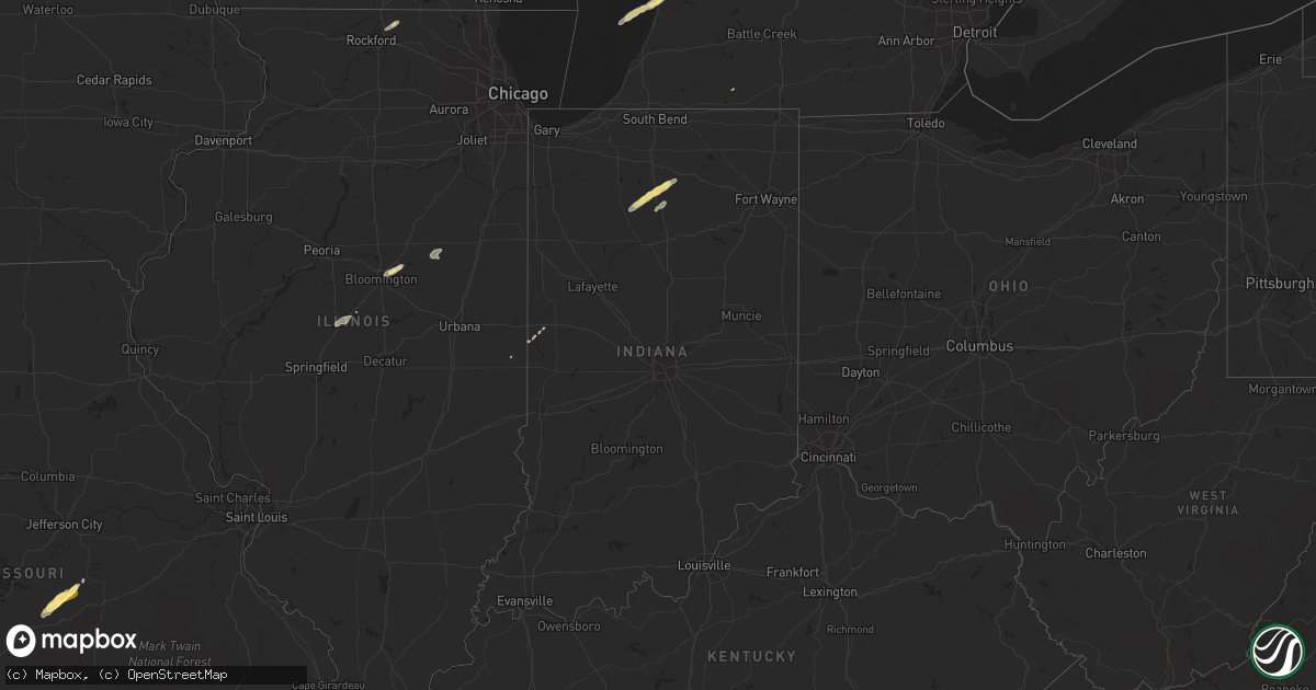
Hail Map in Indiana on January 29, 2013
Get this storm
January 29 map
$229
one time, instant access
Download today. No call, no setup
Keep the $229
Bought the map and want the full workflow? Apply the entire $229 to a subscription within 7 days. None of it is wasted.
Every map, not just this one
This buys you this map. Subscription and you get every map we run, in the markets you choose from a few cities to whole states to nationwide. Plus real-time alerts the moment a storm fires.
Contact data
Name, contact info, occupancy, even credit band for addresses in the footprint. You go from where it hit to who to call.
Become the source they trust
Unlimited branding weather history reports on demand. You already have the documented answer ready for the property owner, and you are the one who showed up with it.
Property data and RoofTrace estimates
Pull up any address you have got, its value and the exact code rules for that jurisdiction, straight from One Click Code. Then RoofTrace estimates the squares, pitch, and roof value, priced the way you price.
Storm reports in Indiana
Indiana
| Date | Description |
|---|---|
| 01/29/20134:25 AM CST | Tree down |
| 01/29/20133:39 AM CST | Barn shifted off of foundation...portions of sheds blown several hundred feet...numerous trees down |
| 01/29/20133:17 AM CST | Four homes and two barns were damaged along hwy 111...the porch of one home was lifted and thrown 30 feet...the walls of one of the barns collapsed in multiple directio |
| 01/29/20133:17 AM CST | Spotter estimated 50-60 mph winds. Time estimated based on radar data. |
| 01/29/20133:15 AM CST | Buildings damaged |
| 01/29/20133:03 AM CST | Power outage reported extending south from state route 58 between walesboro and ogilville |
| 01/29/20133:00 AM CST | Power outage reported extending south from state route 58 between walesboro and ogilville |
| 01/29/20132:28 AM CST | Roof blown off of a residence near state road 160 also 2 barns damaged and power lines down. |
| 01/29/20132:23 AM CST | One tree down |
| 01/29/20132:15 AM CST | Roof blown off of a residence near state road 160 also 2 barns damaged and power lines down. |
| 01/29/20131:48 AM CST | Porch and part of a roof blown off of a house and also trees and power lines down near upper sand hill road. |
| 01/29/20131:45 AM CST | Barn destroyed. |
| 01/29/20131:20 AM CST | Event time is estimated based on radar...damage to a barn and a porch of residence...tree into power lines...wooden lawn furniture blown into roadway |
| 01/29/20131:15 AM CST | Trees downed and minor building damage. |
| 01/29/20131:13 AM CST | State route 43 closed due to power lines across it. Barn destroyed. Time approx. Based on radar. |
| 01/29/20131:04 AM CST | Concrete garage destroyed. |
| 01/29/20131:02 AM CST | Structural damage on a house...including walls down on a garage. Field tanks were also overturned and several trees were downed. Time estimated from radar |
| 01/29/201312:47 AM CST | A home had severe roof damage and its porch was thrown several yards...small twigs driven through the siding of the home...several trees were toppled...ef0 |
| 01/29/201312:45 AM CST | Damage to power lines on east 86th street |
| 01/29/201312:40 AM CST | Barn destroyed...roof landed on pickup truck. |
| 01/29/201312:33 AM CST | A local report indicates 63 MPH wind near TIPTON |
| 01/29/201312:30 AM CST | Roof on concrete garage destroyed. |
| 01/29/201312:30 AM CST | A local report indicates 65 MPH wind near 5 SW BLOOMINGTON |
| 01/29/201312:23 AM CST | A local report indicates 64 MPH wind near BLOOMINGTON |
| 01/29/201312:22 AM CST | A local report indicates 65 MPH wind near 3 S PARAGON |
| 01/29/201312:20 AM CST | Event time approx. Located at twin lakes high school. Report relayed by broadcast media. |
| 01/29/201312:17 AM CST | Several homes damaged and without power between solsbury and hendricksville. Possible tornado. Report received on web eoc. |
| 01/29/201312:13 AM CST | State route 43 closed due to power lines across it. Barn destroyed. Time approx. Based on radar. |
| 01/29/201312:12 AM CST | 2 chopper wagons rolled over and destroyed. Corn crib blown down. Barn door destroyed. Wood from the wagons was blown approx 200 yards se of the wagons. Antenna blown d |
| 01/29/201312:10 AM CST | A local report indicates 70 MPH wind near 2 SE BROWNSBURG |
| 01/29/201312:00 AM CST | Event time estimated from radar imagery |
| 01/28/201311:58 PM CST | Power lines down at oak hill and eastview |
| 01/28/201311:52 PM CST | Cornelius farms lost a machine shed containing combines... Planter... Bean drill and other farm equipment. Debris was strewn out into field east of the farm. Event time |
| 01/28/201311:45 PM CST | A local report indicates 59 MPH wind near GREENCASTLE |
| 01/28/201311:41 PM CST | Tree fell on carpot and power lines down on south gibson road |
| 01/28/201311:35 PM CST | Pieces of aluminum shed blown off into field. Trampoline blown considerable distance into field. Tree limbs blown down and one large chunk of tree blown out at same loc |
| 01/28/201311:31 PM CST | Tree down on 136 east of crawsfordsville...time estimated via radar imagery |
| 01/28/201311:30 PM CST | Window busted out on downtown main st in bicknell at the intersection of 2nd and main street. |
| 01/28/201311:15 PM CST | Tree went through a house. Time estimated from radar and report received on web eoc. |
| 01/28/201311:00 PM CST | A local report indicates 60 MPH wind near TERRE HAUTE |
All States Impacted by Hail Map on January 29, 2013
Cities Impacted by Hail Map on January 29, 2013
- Decatur, TX
- Comanche, TX
- Neodesha, KS
- Hickory Valley, TN
- Memphis, TN
- Southaven, MS
- Lavinia, TN
- Irving, TX
- Thayer, KS
- Jacksboro, TX
- Poolville, TX
- Weatherford, TX
- Cedar Vale, KS
- Shidler, OK
- Robinsonville, MS
- Osceola, MO
- Dixon, MO
- Vienna, MO
- Scotland, AR
- Rich Hill, MO
- Butler, MO
- Hume, MO
- Desdemona, TX
- Mingus, TX
- Stephenville, TX
- Dublin, TX
- Drumright, OK
- Santo, TX
- Huntsville, TX
- Cleveland, AR
- Bolingbrook, IL
- Romeoville, IL
- Hennessey, OK
- Mineral Wells, TX
- Springtown, TX
- Green Ridge, MO
- Fairbury, IL
- Strawn, IL
- Forrest, IL
- Hico, TX
- Oswego, IL
- Bowie, TX
- Bryson, TX
- Jermyn, TX
- Henrietta, TX
- Bellevue, TX
- Blanket, TX
- May, TX
- Sidney, TX
- De Leon, TX
- Alamo, TN
- Marshall, OK
- Red Rock, OK
- Dover, OK
- Lucien, OK
- Garber, OK
- Perry, OK
- Orlando, OK
- Fairmont, OK
- Covington, OK
- Billings, OK
- Morrison, OK
- Douglas, OK
- Bison, OK
- Crocker, MO
- Peggs, OK
- Graham, TX
- Centertown, MO
- Jefferson City, MO
- Hartsburg, MO
- Sardis, MS
- Rising Star, TX
- Gorman, TX
- Shaw, MS
- Doddsville, MS
- Ruleville, MS
- Indianola, MS
- Perrysville, IN
- Cayuga, IN
- Berryville, AR
- Cameron, TX
- West Memphis, AR
- Paradise, TX
- Bridgeport, TX
- Chico, TX
- Baird, TX
- Cross Plains, TX
- Arcadia, KS
- Mulberry, KS
- Lowry City, MO
- Millington, TN
- Arlington, TN
- Lufkin, TX
- Richland, MO
- Giddings, TX
- Lincoln, TX
- Batesville, MS
- Lexington, TX
- Thrall, TX
- Thorndale, TX
- Rockdale, TX
- Ponca City, OK
- Cleveland, MS
- Boyle, MS
- Electra, TX
- Rattan, OK
- Early, TX
- Brownwood, TX
- Saulsbury, TN
- Grand Junction, TN
- Richards, TX
- Millsap, TX
- Tippecanoe, IN
- Kewanna, IN
- Rochester, IN
- Argos, IN
- Star City, IN
- Mentone, IN
- Bourbon, IN
- Winamac, IN
- Etna Green, IN
- Caledonia, IL
- Poplar Grove, IL
- Lockwood, MO
- Arcola, MO
- Greenfield, MO
- Humboldt, KS
- Savonburg, KS
- Chrisman, IL
- Tunica, MS
- Clyde, TX
- Mount Hope, AL
- Moulton, AL
- Carlton, TX
- Kaw City, OK
- Henderson, TN
- Toone, TN
- Medon, TN
- Dardanelle, AR
- Atkins, AR
- Hattieville, AR
- Sedan, KS
- Peru, KS
- Muskogee, OK
- Apple Springs, TX
- Lampe, MO
- Finger, TN
- Covington, TN
- Mason, TN
- Phil Campbell, AL
- Russellville, AL
- Zephyr, TX
- Somerville, TN
- Tolar, TX
- Perkins, OK
- Altoona, KS
- Hickory Hills, IL
- Joliet, IL
- Town Creek, AL
- Palos Park, IL
- Lemont, IL
- Bloomington, IL
- Towanda, IL
- Normal, IL
- Cooksville, IL
- Hamilton, AL
- Waynesville, MO
- Ryan, OK
- Merigold, MS
- Drew, MS
- Tutwiler, MS
- Parchman, MS
- Courtland, MS
- Lambert, MS
- Holly Springs, MS
- Como, MS
- Crenshaw, MS
- Vance, MS
- Marks, MS
- Benoit, MS
- Senatobia, MS
- Crescent, OK
- Kingfisher, OK
- Tonkawa, OK
- Loyal, OK
- Lamar, MS
- Breckenridge, TX
- Burbank, OK
- Fort Scott, KS
- Redfield, KS
- Uniontown, KS
- Daisy, OK
- Middleton, TN
- Marlin, TX
- Fennville, MI
- Henryetta, OK
- Okmulgee, OK
- Liberty, KS
- Edna, KS
- Coffeyville, KS
- Marland, OK
- Pawnee, OK
- Pawhuska, OK
- Shelbyville, TN
- Wann, OK
- Erie, KS
- Galesburg, KS
- Round Top, TX
- Burton, TX
- Wichita Falls, TX
- Oklahoma City, OK
- Arlington, TX
- Hamilton, TX
- Smithville, TX
- Nauvoo, AL
- Lynn, AL
- Sedalia, MO
- La Monte, MO
- Bastrop, TX
- Palo Pinto, TX
- Gordon, TX
- Lipan, TX
- Hornsby, TN
- Bolivar, TN
- Eufaula, OK
- Shawnee, OK
- Mansfield, TX
- Burleson, TX
- Fort Worth, TX
- Byhalia, MS
- Red Banks, MS
- Rayville, LA
- Boyd, TX
- Fletcher, OK
- Cement, OK
- Coldwater, MS
- Aurora, IL
- Grand Prairie, TX
- Horn Lake, MS
- Nesbit, MS
- Wister, OK
- Amory, MS
- Detroit, AL
- Sulligent, AL
- Greenwood Springs, MS
- Lenapah, OK
- Milano, TX
- Golden City, MO
- Sturgis, MI
- Waurika, OK
- Ringling, OK
- Glencoe, OK
- S Coffeyville, OK
- Altamont, KS
- Moline, KS
- Grenola, KS
- Cordova, TN
- Bixby, OK
- Haskell, OK
- El Dorado Springs, MO
- Collins, MO
- Antlers, OK
- Covington, IN
- Mustang, OK
- Lyon, MS
- Coahoma, MS
- Bethel Springs, TN
- Winfield, AL
- Eldridge, AL
- Elk City, KS
- Oswego, KS
- Parsons, KS
- McCune, KS
- Stark, KS
- Brownsville, TN
- Hackleburg, AL
- Graford, TX
- Lexington, IL
- Duncan, OK
- Boley, OK
- California, MO
- Booneville, AR
- Cropsey, IL
- Atlanta, IL
- Durant, MS
- Groveton, TX
- Lockport, IL
- Homer Glen, IL
- Bear Creek, AL
- Haleyville, AL
- Double Springs, AL
- Tuttle, OK
- Perrin, TX
- Newkirk, OK
- Russellville, MO
- Liberal, MO
- Paige, TX
- Seminole, OK
- Windthorst, TX
- Loving, TX
- Lake Cormorant, MS
- Warsaw, IN
- Morris, IL
- Seneca, IL
- Marseilles, IL
- Dewey, OK
- Spavinaw, OK
- Lincoln, IL
- Chanute, KS
- Talihina, OK
- Geary, OK
- Watonga, OK
- Calumet, OK
- Okarche, OK
- Bethany, OK
- Sentinel, OK
- Canute, OK
- Dill City, OK
- Carter, OK
- Foss, OK


