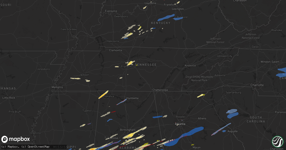
Hail Map in Tennessee on January 12, 2023
Get this storm
January 12 map
$229
one time, instant access
Download today. No call, no setup
Keep the $229
Bought the map and want the full workflow? Apply the entire $229 to a subscription within 7 days. None of it is wasted.
Every map, not just this one
This buys you this map. Subscription and you get every map we run, in the markets you choose from a few cities to whole states to nationwide. Plus real-time alerts the moment a storm fires.
Contact data
Name, contact info, occupancy, even credit band for addresses in the footprint. You go from where it hit to who to call.
Become the source they trust
Unlimited branding weather history reports on demand. You already have the documented answer ready for the property owner, and you are the one who showed up with it.
Property data and RoofTrace estimates
Pull up any address you have got, its value and the exact code rules for that jurisdiction, straight from One Click Code. Then RoofTrace estimates the squares, pitch, and roof value, priced the way you price.
Storm reports in Tennessee
Tennessee
| Date | Description |
|---|---|
| 01/12/20233:45 PM CST | Corrects previous non-tstm wnd dmg report from 5 n iron city. Tree down blocking road at 3320 wayland springs rd. |
| 01/12/20231:53 PM CST | Quarter-sized hail reported north of walterhill. Time estimated via radar. |
| 01/12/20231:40 PM CST | Corrects previous non-tstm wnd dmg report from 5 s smyrna. Tspotter report and photo showed a large tree limb fell and crushed a shed on blackman rd. |
| 01/12/20231:22 PM CST | Quarter size hail falling at the corner of harding pike and i-24. Time estimated by radar. |
| 01/12/20231:21 PM CST | Hail slightly larger than a quarter reported in the area of sweetwater drive and little stone drive in brentwood. |
| 01/12/20231:19 PM CST | Twitter photo showing up to ping pong ball sized hail in nippers corner. Time estimated via radar. |
| 01/12/20231:19 PM CST | Corrects previous non-tstm wnd gst report from tri-city airport. Asos station ktri tri-cities airport. |
| 01/12/20231:19 PM CST | Quarter size hail in nippers corner. Time estimated by radar. |
| 01/12/20231:19 PM CST | Twitter photo of half-dollar size hail at nippers corner. |
| 01/12/202312:54 PM CST | Shingles were blown off houses and trees knocked down in the tusculum area. |
| 01/12/202312:33 PM CST | Several reports of trees down county wide. |
| 01/12/202312:26 PM CST | Preliminary storm survey finds a path of ef-0 damage with max winds of 80 mph. Path length of 1 mile and width of 100 yards. |
| 01/12/202312:20 PM CST | Near highway 92. |
| 01/12/202312:20 PM CST | Multiple trees down along mobile road. |
| 01/12/202312:17 PM CST | Shingles missing from roof and one large tree blown down. |
| 01/12/202312:14 PM CST | The tornado developed west of dandridge and crossed deep springs road. It dissipated on the east side of deep springs road near ranch road. |
| 01/12/202312:10 PM CST | Tree down blocking roberts road at sunrise blvd. |
| 01/12/202312:03 PM CST | Report of trees down across blount county. |
| 01/12/202311:55 AM CST | Widespread trees down across the county. |
| 01/12/202311:54 AM CST | Tree was blown down onto power lines and is blocking the road. |
| 01/12/202311:45 AM CST | Corrects previous non-tstm wnd gst report from 2 n alcoa. Asos station ktys knoxville mcghee tyson. |
| 01/12/202311:09 AM CST | Trees down. |
| 01/12/202310:50 AM CST | *** 1 inj *** straight line winds were observed to have caused several downed trees and minor outbuilding damage near decatur creek and goodfield road. A tornado develo |
| 01/12/202310:01 AM CST | Corrects previous tstm wnd dmg report from 5 ne griffith creek. Several reports of trees down county wide. |
All States Impacted by Hail Map on January 12, 2023
Cities Impacted by Hail Map on January 12, 2023
- Oak Vale, MS
- Monticello, MS
- Prentiss, MS
- Bassfield, MS
- Carson, MS
- Silver Creek, MS
- Jayess, MS
- Carthage, MS
- Aberdeen, MS
- Latham, OH
- Peebles, OH
- Bainbridge, OH
- Waverly, OH
- Hillsboro, OH
- Lewisburg, KY
- Bowling Green, KY
- Morgantown, KY
- Bee Spring, KY
- Leitchfield, KY
- Clarkson, KY
- Meridian, MS
- Collinsville, MS
- Marion, MS
- Emelle, AL
- Scooba, MS
- Springfield, KY
- Harrodsburg, KY
- Wilmore, KY
- Mackville, KY
- Lancaster, KY
- Nicholasville, KY
- Saint Francis, KY
- Perryville, KY
- Lebanon, KY
- Loretto, KY
- Richmond, KY
- Paint Lick, KY
- Danville, KY
- Falmouth, KY
- Dry Ridge, KY
- Williamstown, KY
- Russellville, KY
- Greensburg, KY
- Summersville, KY
- Siler City, NC
- Randleman, NC
- Pittsboro, NC
- Liberty, NC
- Asheboro, NC
- Snow Camp, NC
- Sophia, NC
- Staley, NC
- Franklinville, NC
- Climax, NC
- Ramseur, NC
- Bear Creek, NC
- Bennett, NC
- Goldston, NC
- Seagrove, NC
- Sanford, NC
- Moncure, NC
- Ninety Six, SC
- Chappells, SC
- Mountville, SC
- Kinards, SC
- Greenwood, SC
- Newberry, SC
- Waterloo, SC
- Abbeville, SC
- Silverstreet, SC
- Cross Hill, SC
- Saluda, SC
- Troy, SC
- Bradley, SC
- Decatur, AL
- Moulton, AL
- Trinity, AL
- Tanner, AL
- Madison, AL
- Fayette, AL
- Carbon Hill, AL
- Eldridge, AL
- Boligee, AL
- Akron, AL
- Eutaw, AL
- Knoxville, AL
- Centreville, AL
- Duncanville, AL
- West Blocton, AL
- Gainesville, AL
- Epes, AL
- Moundville, AL
- Waverly, AL
- Auburn University, AL
- Notasulga, AL
- Opelika, AL
- Auburn, AL
- Cusseta, AL
- Salem, AL
- Valley, AL
- Montgomery, AL
- Shorter, AL
- Lowndesboro, AL
- Hope Hull, AL
- Tyler, AL
- Tuskegee, AL
- Hayneville, AL
- Selma, AL
- Cecil, AL
- Pike Road, AL
- Wetumpka, AL
- Tallassee, AL
- Range, AL
- Dozier, AL
- Elba, AL
- Ariton, AL
- Castleberry, AL
- Brantley, AL
- Evergreen, AL
- Atmore, AL
- McKenzie, AL
- Abbeville, AL
- Red Level, AL
- Clio, AL
- Opp, AL
- Repton, AL
- Georgetown, GA
- Morris, GA
- Lenox, AL
- Cuthbert, GA
- Dawson, GA
- Brundidge, AL
- Skipperville, AL
- Coleman, GA
- Louisville, AL
- Clayton, AL
- Eufaula, AL
- Clopton, AL
- Jack, AL
- Andalusia, AL
- Troy, AL
- Fort Gaines, GA
- Brewton, AL
- Shellman, GA
- Glenwood, AL
- Piedmont, AL
- Cedartown, GA
- Morgan, GA
- Headland, AL
- Arlington, GA
- Blakely, GA
- Leary, GA
- Columbia, AL
- Damascus, GA
- Edison, GA
- Bluffton, GA
- Albany, GA
- Belleville, WV
- Mineral Wells, WV
- Washington, WV
- Parkersburg, WV
- Davisville, WV
- Elizabeth, IN
- Laconia, IN
- Antioch, TN
- Nolensville, TN
- La Vergne, TN
- Georgetown, KY
- Columbia, TN
- Culleoka, TN
- Mount Pleasant, TN
- Mammoth Cave, KY
- Cave City, KY
- Phil Campbell, AL
- Nashville, TN
- Brentwood, TN
- Hardyville, KY
- Canmer, KY
- Goodwater, AL
- Sylacauga, AL
- Weogufka, AL
- Cub Run, KY
- Silas, AL
- Caneyville, KY
- Horse Branch, KY
- Cromwell, KY
- Horse Cave, KY
- Munfordville, KY
- Lewisburg, TN
- Elk Horn, KY
- Dunmor, KY
- Jeffersonville, IN
- Franklin, TN
- Hermitage, TN
- Mount Juliet, TN
- Pine Hill, AL
- Sawyerville, AL
- Greensboro, AL
- Anniston, AL
- Lincoln, AL
- Eastaboga, AL
- Thomasville, AL
- Beaverton, AL
- Hamilton, AL
- Haleyville, AL
- Guin, AL
- Bear Creek, AL
- Brilliant, AL
- Cynthiana, KY
- Sadieville, KY
- Magnolia, KY
- Deatsville, AL
- Equality, AL
- Marbury, AL
- Titus, AL
- Rockford, AL
- Five Points, AL
- Lafayette, AL
- Roanoke, AL
- Wadley, AL
- Daviston, AL
- Camp Hill, AL
- Columbiana, AL
- Birmingham, AL
- Pelham, AL
- Chelsea, AL
- Coxs Mills, WV
- Smithville, WV
- Auburn, WV
- Bon Aqua, TN
- Lyles, TN
- Nunnelly, TN
- Brownsville, KY
- Porterville, MS
- De Kalb, MS
- Union, MS
- Taylorsville, MS
- Taylorsville, GA
- Rockmart, GA
- Aragon, GA
- Butler, AL
- Rhine, GA
- Milan, GA
- Eastman, GA
- Chauncey, GA
- Dothan, AL
- Vincent, AL
- Leakesville, MS
- Stanton, TN
- Alpine, AL
- Talladega, AL
- Henderson, TN
- Finger, TN
- Sumner, GA
- Ty Ty, GA
- Doerun, GA
- Sylvester, GA
- Poulan, GA
- Cedarbluff, MS
- West Point, MS
- Jones, AL
- Canton, MS
- Tuscaloosa, AL
- Brookwood, AL
- Vinegar Bend, AL
- Deer Park, AL
- Citronelle, AL
- Clayton, GA
- Tiger, GA
- Jacksons Gap, AL
- Poplarville, MS
- Lebanon, TN
- Lauderdale, MS
- Cuba, AL
- Mercer, TN
- Brownsville, TN
- Medon, TN
- Whiteville, TN
- Childersburg, AL
- Greenville, GA
- Hogansville, GA
- West Point, GA
- Mantee, MS
- Pheba, MS
- York, AL
- Livingston, AL
- Toomsuba, MS
- Cherokee, AL
- Florence, AL
- Waterloo, AL
- Toxey, AL
- Safford, AL
- Linden, AL
- Thomaston, AL
- Catherine, AL
- Magnolia, AL
- Sweet Water, AL
- Dixons Mills, AL
- Jackson, OH
- Beaver, OH
- Hartford, AL
- Slocomb, AL
- Saint Marys, WV
- Waverly, WV
- Mount Vernon, AL
- Lucedale, MS
- Chunchula, AL
- Clarkesville, GA
- Lakemont, GA
- Alabaster, AL
- Prattville, AL
- Pachuta, MS
- Quitman, MS
- Cropwell, AL
- Tifton, GA
- Sterrett, AL
- Folsom, LA
- Ocilla, GA
- Lagrange, GA
- Chattahoochee, FL
- Calera, AL
- Sardinia, OH
- Georgetown, OH
- Millry, AL
- Frankville, AL
- Jackson, AL
- Waynesboro, MS
- Coffeeville, AL
- Buckatunna, MS
- Shubuta, MS
- Smiths Grove, KY
- Sardis, AL
- Orrville, AL
- Minter, AL
- Rochelle, GA
- Pitts, GA
- Vienna, GA
- Chula, GA
- Laurel, MS
- Stringer, MS
- Heidelberg, MS
- Vossburg, MS
- Shuqualak, MS
- Hickory, MS
- Chunky, MS
- Decatur, MS
- Arabi, GA
- Cordele, GA
- Kellyton, AL
- Alexander City, AL
- Lena, MS
- Shelby, AL
- Pineview, GA
- Cobb, GA
- De Soto, GA
- Abbeville, GA
- Billingsley, AL
- Autaugaville, AL
- Marion Junction, AL
- Melvin, AL
- Needham, AL
- Gilbertown, AL
- Sneads, FL
- Lower Peach Tree, AL
- Dickinson, AL
- Grove Hill, AL
- Montevallo, AL
- Helena, AL
- Brierfield, AL
- Randolph, AL
- Wilsonville, AL
- McRae Helena, GA
- Verbena, AL
- Luthersville, GA
- Coy, AL
- Vredenburgh, AL
- Marianna, FL
- Altha, FL
- Quincy, FL
- Grand Ridge, FL
- Harpersville, AL
- Pell City, AL
- Munford, AL
- Oxford, AL
- Fitzgerald, GA
- Camden, AL
- Philadelphia, MS
- Pine Apple, AL
- Franklin, GA
- Cadwell, GA
- Warwick, GA
- Jetson, KY
- Roundhill, KY
- Atlanta, GA
- Brandon, MS
- Walnut Grove, MS
- Samson, AL
- Sharon Grove, KY
- Iron City, TN
- Iuka, MS
- Lanett, AL
- Macon, MS
- Dadeville, AL
- Uniontown, AL
- Bay Springs, MS
- Newton, MS
- Brent, AL
- Marion, AL
- Forkland, AL
- Ovett, MS
- Gordon, AL
- Jakin, GA
- Buhl, AL
- Ralph, AL
- Northport, AL
- Jemison, AL
- Clanton, AL
- Geneva, AL
- Defuniak Springs, FL
- Arlington, AL
- Franklinton, LA
- Loranger, LA
- Sycamore, GA
- Baconton, GA
- Newton, GA
- Ashburn, GA
- Ellisville, MS
- Gay, GA
- Molena, GA
- Monticello, GA
- Mcdonough, GA
- Williamson, GA
- Buckhead, GA
- Jenkinsburg, GA
- Concord, GA
- Rutledge, GA
- Shady Dale, GA
- Mansfield, GA
- Greensboro, GA
- Newborn, GA
- Pine Mountain, GA
- Brooks, GA
- Woodbury, GA
- Warm Springs, GA
- Griffin, GA
- Madison, GA
- Jackson, GA
- Covington, GA
- Hampton, GA
- Locust Grove, GA
- Thomson, GA
- Norwood, GA
- Clarks Hill, SC
- Sparta, GA
- Appling, GA
- Edgefield, SC
- Camak, GA
- Modoc, SC
- Warrenton, GA
- Harlem, GA
- Dearing, GA
- Smithville, GA
- Americus, GA
- Leesburg, GA
- Bronwood, GA
- Leslie, GA
- Centerville, GA
- Macon, GA
- Warner Robins, GA
- Colquitt, GA
- Camilla, GA
- Double Springs, AL
- Pleasureville, KY
- Lithia Springs, GA
- Austell, GA
- Juliette, GA
- Alamo, GA
- Murfreesboro, TN
- Lascassas, TN


