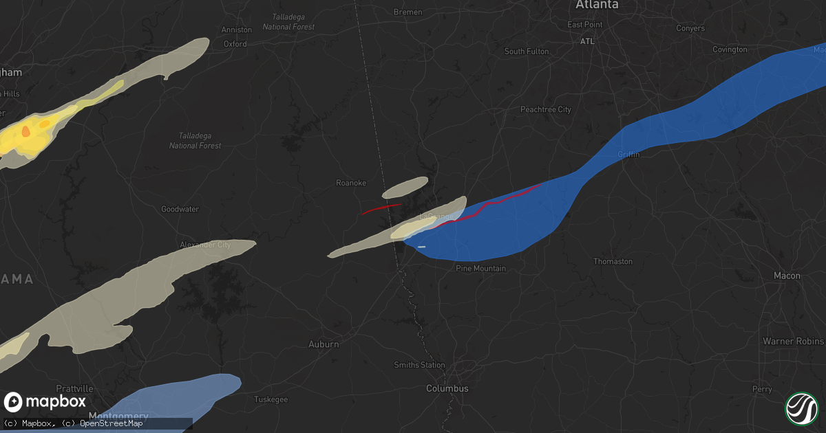
Hail Map in Lagrange, GA on January 12, 2023
Get this storm
January 12 map
$229
one time, instant access
Download today. No call, no setup
Keep the $229
Bought the map and want the full workflow? Apply the entire $229 to a subscription within 7 days. None of it is wasted.
Every map, not just this one
This buys you this map. Subscription and you get every map we run, in the markets you choose from a few cities to whole states to nationwide. Plus real-time alerts the moment a storm fires.
Contact data
Name, contact info, occupancy, even credit band for addresses in the footprint. You go from where it hit to who to call.
Become the source they trust
Unlimited branding weather history reports on demand. You already have the documented answer ready for the property owner, and you are the one who showed up with it.
Property data and RoofTrace estimates
Pull up any address you have got, its value and the exact code rules for that jurisdiction, straight from One Click Code. Then RoofTrace estimates the squares, pitch, and roof value, priced the way you price.
Storm reports in Lagrange, GA
Lagrange, GA
| Date | Description |
|---|---|
| 01/12/20233:16 PM CST | Multiple trees down on exit 46... Big springs rd... On i-185. Road completely blocked. |
| 01/12/20232:37 PM CST | Tornado confirmed by radar and damage reports southeast side of lagrange. Major structural damage and numerous trees downed blocking i85. |
| 01/12/20232:37 PM CST | Tornado reported in area of upper big springs and davis road. |
| 01/12/20232:29 PM CST | More than 3 trees down in the area of upper big springs rd and hwy185. |
All States Impacted by Hail Map on January 12, 2023
All Cities Impacted by Hail Map on January 12, 2023
- Oak Vale, MS
- Monticello, MS
- Prentiss, MS
- Bassfield, MS
- Carson, MS
- Silver Creek, MS
- Jayess, MS
- Carthage, MS
- Aberdeen, MS
- Latham, OH
- Peebles, OH
- Bainbridge, OH
- Waverly, OH
- Hillsboro, OH
- Lewisburg, KY
- Bowling Green, KY
- Morgantown, KY
- Bee Spring, KY
- Leitchfield, KY
- Clarkson, KY
- Meridian, MS
- Collinsville, MS
- Marion, MS
- Emelle, AL
- Scooba, MS
- Springfield, KY
- Harrodsburg, KY
- Wilmore, KY
- Mackville, KY
- Lancaster, KY
- Nicholasville, KY
- Saint Francis, KY
- Perryville, KY
- Lebanon, KY
- Loretto, KY
- Richmond, KY
- Paint Lick, KY
- Danville, KY
- Falmouth, KY
- Dry Ridge, KY
- Williamstown, KY
- Russellville, KY
- Greensburg, KY
- Summersville, KY
- Siler City, NC
- Randleman, NC
- Pittsboro, NC
- Liberty, NC
- Asheboro, NC
- Snow Camp, NC
- Sophia, NC
- Staley, NC
- Franklinville, NC
- Climax, NC
- Ramseur, NC
- Bear Creek, NC
- Bennett, NC
- Goldston, NC
- Seagrove, NC
- Sanford, NC
- Moncure, NC
- Ninety Six, SC
- Chappells, SC
- Mountville, SC
- Kinards, SC
- Greenwood, SC
- Newberry, SC
- Waterloo, SC
- Abbeville, SC
- Silverstreet, SC
- Cross Hill, SC
- Saluda, SC
- Troy, SC
- Bradley, SC
- Decatur, AL
- Moulton, AL
- Trinity, AL
- Tanner, AL
- Madison, AL
- Fayette, AL
- Carbon Hill, AL
- Eldridge, AL
- Boligee, AL
- Akron, AL
- Eutaw, AL
- Knoxville, AL
- Centreville, AL
- Duncanville, AL
- West Blocton, AL
- Gainesville, AL
- Epes, AL
- Moundville, AL
- Waverly, AL
- Auburn University, AL
- Notasulga, AL
- Opelika, AL
- Auburn, AL
- Cusseta, AL
- Salem, AL
- Valley, AL
- Montgomery, AL
- Shorter, AL
- Lowndesboro, AL
- Hope Hull, AL
- Tyler, AL
- Tuskegee, AL
- Hayneville, AL
- Selma, AL
- Cecil, AL
- Pike Road, AL
- Wetumpka, AL
- Tallassee, AL
- Range, AL
- Dozier, AL
- Elba, AL
- Ariton, AL
- Castleberry, AL
- Brantley, AL
- Evergreen, AL
- Atmore, AL
- McKenzie, AL
- Abbeville, AL
- Red Level, AL
- Clio, AL
- Opp, AL
- Repton, AL
- Georgetown, GA
- Morris, GA
- Lenox, AL
- Cuthbert, GA
- Dawson, GA
- Brundidge, AL
- Skipperville, AL
- Coleman, GA
- Louisville, AL
- Clayton, AL
- Eufaula, AL
- Clopton, AL
- Jack, AL
- Andalusia, AL
- Troy, AL
- Fort Gaines, GA
- Brewton, AL
- Shellman, GA
- Glenwood, AL
- Piedmont, AL
- Cedartown, GA
- Morgan, GA
- Headland, AL
- Arlington, GA
- Blakely, GA
- Leary, GA
- Columbia, AL
- Damascus, GA
- Edison, GA
- Bluffton, GA
- Albany, GA
- Belleville, WV
- Mineral Wells, WV
- Washington, WV
- Parkersburg, WV
- Davisville, WV
- Elizabeth, IN
- Laconia, IN
- Antioch, TN
- Nolensville, TN
- La Vergne, TN
- Georgetown, KY
- Columbia, TN
- Culleoka, TN
- Mount Pleasant, TN
- Mammoth Cave, KY
- Cave City, KY
- Phil Campbell, AL
- Nashville, TN
- Brentwood, TN
- Hardyville, KY
- Canmer, KY
- Goodwater, AL
- Sylacauga, AL
- Weogufka, AL
- Cub Run, KY
- Silas, AL
- Caneyville, KY
- Horse Branch, KY
- Cromwell, KY
- Horse Cave, KY
- Munfordville, KY
- Lewisburg, TN
- Elk Horn, KY
- Dunmor, KY
- Jeffersonville, IN
- Franklin, TN
- Hermitage, TN
- Mount Juliet, TN
- Pine Hill, AL
- Sawyerville, AL
- Greensboro, AL
- Anniston, AL
- Lincoln, AL
- Eastaboga, AL
- Thomasville, AL
- Beaverton, AL
- Hamilton, AL
- Haleyville, AL
- Guin, AL
- Bear Creek, AL
- Brilliant, AL
- Cynthiana, KY
- Sadieville, KY
- Magnolia, KY
- Deatsville, AL
- Equality, AL
- Marbury, AL
- Titus, AL
- Rockford, AL
- Five Points, AL
- Lafayette, AL
- Roanoke, AL
- Wadley, AL
- Daviston, AL
- Camp Hill, AL
- Columbiana, AL
- Birmingham, AL
- Pelham, AL
- Chelsea, AL
- Coxs Mills, WV
- Smithville, WV
- Auburn, WV
- Bon Aqua, TN
- Lyles, TN
- Nunnelly, TN
- Brownsville, KY
- Porterville, MS
- De Kalb, MS
- Union, MS
- Taylorsville, MS
- Taylorsville, GA
- Rockmart, GA
- Aragon, GA
- Butler, AL
- Rhine, GA
- Milan, GA
- Eastman, GA
- Chauncey, GA
- Dothan, AL
- Vincent, AL
- Leakesville, MS
- Stanton, TN
- Alpine, AL
- Talladega, AL
- Henderson, TN
- Finger, TN
- Sumner, GA
- Ty Ty, GA
- Doerun, GA
- Sylvester, GA
- Poulan, GA
- Cedarbluff, MS
- West Point, MS
- Jones, AL
- Canton, MS
- Tuscaloosa, AL
- Brookwood, AL
- Vinegar Bend, AL
- Deer Park, AL
- Citronelle, AL
- Clayton, GA
- Tiger, GA
- Jacksons Gap, AL
- Poplarville, MS
- Lebanon, TN
- Lauderdale, MS
- Cuba, AL
- Mercer, TN
- Brownsville, TN
- Medon, TN
- Whiteville, TN
- Childersburg, AL
- Greenville, GA
- Hogansville, GA
- West Point, GA
- Mantee, MS
- Pheba, MS
- York, AL
- Livingston, AL
- Toomsuba, MS
- Cherokee, AL
- Florence, AL
- Waterloo, AL
- Toxey, AL
- Safford, AL
- Linden, AL
- Thomaston, AL
- Catherine, AL
- Magnolia, AL
- Sweet Water, AL
- Dixons Mills, AL
- Jackson, OH
- Beaver, OH
- Hartford, AL
- Slocomb, AL
- Saint Marys, WV
- Waverly, WV
- Mount Vernon, AL
- Lucedale, MS
- Chunchula, AL
- Clarkesville, GA
- Lakemont, GA
- Alabaster, AL
- Prattville, AL
- Pachuta, MS
- Quitman, MS
- Cropwell, AL
- Tifton, GA
- Sterrett, AL
- Folsom, LA
- Ocilla, GA
- Lagrange, GA
- Chattahoochee, FL
- Calera, AL
- Sardinia, OH
- Georgetown, OH
- Millry, AL
- Frankville, AL
- Jackson, AL
- Waynesboro, MS
- Coffeeville, AL
- Buckatunna, MS
- Shubuta, MS
- Smiths Grove, KY
- Sardis, AL
- Orrville, AL
- Minter, AL
- Rochelle, GA
- Pitts, GA
- Vienna, GA
- Chula, GA
- Laurel, MS
- Stringer, MS
- Heidelberg, MS
- Vossburg, MS
- Shuqualak, MS
- Hickory, MS
- Chunky, MS
- Decatur, MS
- Arabi, GA
- Cordele, GA
- Kellyton, AL
- Alexander City, AL
- Lena, MS
- Shelby, AL
- Pineview, GA
- Cobb, GA
- De Soto, GA
- Abbeville, GA
- Billingsley, AL
- Autaugaville, AL
- Marion Junction, AL
- Melvin, AL
- Needham, AL
- Gilbertown, AL
- Sneads, FL
- Lower Peach Tree, AL
- Dickinson, AL
- Grove Hill, AL
- Montevallo, AL
- Helena, AL
- Brierfield, AL
- Randolph, AL
- Wilsonville, AL
- McRae Helena, GA
- Verbena, AL
- Luthersville, GA
- Coy, AL
- Vredenburgh, AL
- Marianna, FL
- Altha, FL
- Quincy, FL
- Grand Ridge, FL
- Harpersville, AL
- Pell City, AL
- Munford, AL
- Oxford, AL
- Fitzgerald, GA
- Camden, AL
- Philadelphia, MS
- Pine Apple, AL
- Franklin, GA
- Cadwell, GA
- Warwick, GA
- Jetson, KY
- Roundhill, KY
- Atlanta, GA
- Brandon, MS
- Walnut Grove, MS
- Samson, AL
- Sharon Grove, KY
- Iron City, TN
- Iuka, MS
- Lanett, AL
- Macon, MS
- Dadeville, AL
- Uniontown, AL
- Bay Springs, MS
- Newton, MS
- Brent, AL
- Marion, AL
- Forkland, AL
- Ovett, MS
- Gordon, AL
- Jakin, GA
- Buhl, AL
- Ralph, AL
- Northport, AL
- Jemison, AL
- Clanton, AL
- Geneva, AL
- Defuniak Springs, FL
- Arlington, AL
- Franklinton, LA
- Loranger, LA
- Sycamore, GA
- Baconton, GA
- Newton, GA
- Ashburn, GA
- Ellisville, MS
- Gay, GA
- Molena, GA
- Monticello, GA
- Mcdonough, GA
- Williamson, GA
- Buckhead, GA
- Jenkinsburg, GA
- Concord, GA
- Rutledge, GA
- Shady Dale, GA
- Mansfield, GA
- Greensboro, GA
- Newborn, GA
- Pine Mountain, GA
- Brooks, GA
- Woodbury, GA
- Warm Springs, GA
- Griffin, GA
- Madison, GA
- Jackson, GA
- Covington, GA
- Hampton, GA
- Locust Grove, GA
- Thomson, GA
- Norwood, GA
- Clarks Hill, SC
- Sparta, GA
- Appling, GA
- Edgefield, SC
- Camak, GA
- Modoc, SC
- Warrenton, GA
- Harlem, GA
- Dearing, GA
- Smithville, GA
- Americus, GA
- Leesburg, GA
- Bronwood, GA
- Leslie, GA
- Centerville, GA
- Macon, GA
- Warner Robins, GA
- Colquitt, GA
- Camilla, GA
- Double Springs, AL
- Pleasureville, KY
- Lithia Springs, GA
- Austell, GA
- Juliette, GA
- Alamo, GA
- Murfreesboro, TN
- Lascassas, TN


