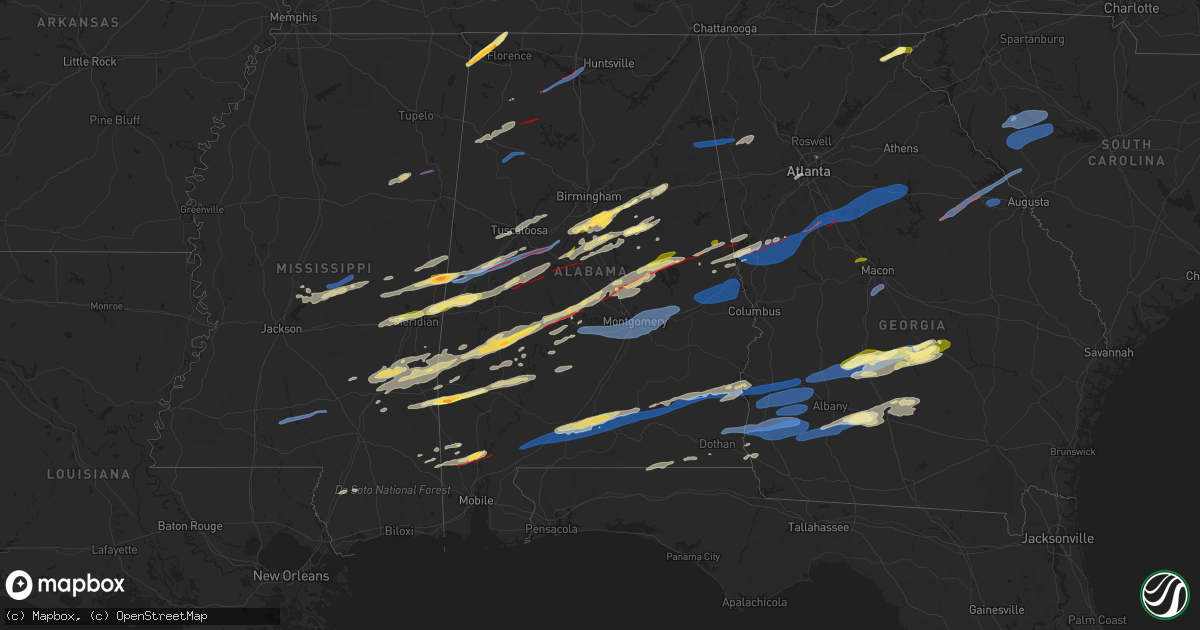
Hail Map in Alabama on January 12, 2023
Get this storm
January 12 map
$229
one time, instant access
Download today. No call, no setup
Keep the $229
Bought the map and want the full workflow? Apply the entire $229 to a subscription within 7 days. None of it is wasted.
Every map, not just this one
This buys you this map. Subscription and you get every map we run, in the markets you choose from a few cities to whole states to nationwide. Plus real-time alerts the moment a storm fires.
Contact data
Name, contact info, occupancy, even credit band for addresses in the footprint. You go from where it hit to who to call.
Become the source they trust
Unlimited branding weather history reports on demand. You already have the documented answer ready for the property owner, and you are the one who showed up with it.
Property data and RoofTrace estimates
Pull up any address you have got, its value and the exact code rules for that jurisdiction, straight from One Click Code. Then RoofTrace estimates the squares, pitch, and roof value, priced the way you price.
Storm reports in Alabama
Alabama
| Date | Description |
|---|---|
| 01/12/20235:57 PM CST | A tree was blown down onto county road 49. |
| 01/12/20235:57 PM CST | A tree was blown down onto county road 30. |
| 01/12/20235:50 PM CST | Three trees were blown down in the hartford area. |
| 01/12/20235:27 PM CST | Tree down in coffee springs. |
| 01/12/20235:03 PM CST | Measured wind gust of 63 mph. |
| 01/12/20233:50 PM CST | Numerous trees and powerlines down across the northern portion of henry county... North of abbeville. 1 home with structural damage. |
| 01/12/20233:45 PM CST | Report of damage at bakerhill school road and cr 79. |
| 01/12/20233:45 PM CST | Four to six trees down in different directions across cr 126. |
| 01/12/20233:41 PM CST | Damage reported along mavis carroll road. |
| 01/12/20233:40 PM CST | Roof or structural damage was reported at this location. |
| 01/12/20233:40 PM CST | Corrects previous tstm wnd dmg report from 3 ne pisgah. Corrects previous tstm wnd dmg report from 3 ne pisgah. Roof or structural damage was reported at this location. |
| 01/12/20233:37 PM CST | Corrects previous tstm wnd dmg report from 3 ne pisgah. Roof or structural damage was reported at this location. |
| 01/12/20233:33 PM CST | Trees down on cr 68 and cr 33. |
| 01/12/20233:33 PM CST | Multiple trees down and structural damage at blue springs state park. Tds observed via radar. |
| 01/12/20233:32 PM CST | Damage along cr 23 near new hope church. Tds observed. |
| 01/12/20233:21 PM CST | Trees down at sr-123 and county road 120... Blocking both lanes. |
| 01/12/20233:21 PM CST | River road at barbour county line is closed due to numerous trees and powerlines down. |
| 01/12/20233:18 PM CST | Trees down across highway 51 and county road 52 near ariton. |
| 01/12/20233:15 PM CST | Numerous large trees down along us 231 and neighboring roads near the pike/coffee county line. Possible tornado. |
| 01/12/20233:01 PM CST | Numerous trees and powerlines down along sr-87 between jack post office and zion chapel school with road blocked. |
| 01/12/20232:41 PM CST | Em report of downed trees and power lines resulting in numerous power outages in opelika. |
| 01/12/20232:41 PM CST | Weather station at auburn university recorded gust of 67 mph. |
| 01/12/20232:40 PM CST | Em reports minor damage to an abandon trailer in the rose hill area on county road 13 with trees also down in the area. |
| 01/12/20232:38 PM CST | Em reports trees down along straughn school rd in rose hill area. Time estimated based on radar. |
| 01/12/20232:35 PM CST | Em reports multiple locations in extreme south crenshaw county with fallen trees and downed power lines. One broken power pole... One location with chicken house damage |
| 01/12/20232:30 PM CST | Reports of trees down near and around gantt lake. Extent of damage unknown at this time. |
| 01/12/20232:24 PM CST | Home destroyed on cr 284 in northeast chambers county. Tds visible via radar. |
| 01/12/20232:19 PM CST | Photo on social media of damage on crystal springs rd in red level... Al next to football stadium. Time estimated based on radar. |
| 01/12/20232:18 PM CST | Em reports damage to a structure on cr 107 and on smiley street in red level area. Time estimated based on radar. |
| 01/12/20232:17 PM CST | Many large pine trees and hardwood trees down across cr 267. Trees on power lines. Tds observed. |
| 01/12/20232:14 PM CST | Quarter-sized hail reported in the clackville community. |
| 01/12/20232:13 PM CST | Trees and lines down in and around tallassee. |
| 01/12/20232:06 PM CST | Asos report of 62 mph gust at dannelly field. |
| 01/12/20232:03 PM CST | Damage reported along hunter lane and camellia drive. |
| 01/12/20232:01 PM CST | Minor tree damage reported. |
| 01/12/20231:56 PM CST | Em reports of trees and power lines down in between castleberry and nymph. |
| 01/12/20231:55 PM CST | Media report of minor structural damage to a plantation home on jay villa rd a near intersection of rowe rd and monroe dr. |
| 01/12/20231:55 PM CST | Media report of minor structural damage to a plantation home on jay villa rd along with trees down on the property. Time estimated based on radar - possible tor. |
| 01/12/20231:54 PM CST | Em reports widespread tree damage due to a possible tor around intersections of cr 85... Cr 87... And cr 29. Numerous large trees uprooted & snapped |
| 01/12/20231:51 PM CST | Social media report of trees and power lines down on horseshoe bend road northeast of jacksons gap. Possible tornado. |
| 01/12/20231:48 PM CST | Trees and lines down in and around dadeville. |
| 01/12/20231:45 PM CST | Reports of roof damage on sandcut rd. Extent of damage unknown at this time. |
| 01/12/20231:42 PM CST | Multiple structures damaged along us 280 near the lake martin bridge. Tds observed. |
| 01/12/20231:42 PM CST | Em reports 4 residential homes and 1 church having structural damage... And 1 large barn was destroyed on appleton rd |
| 01/12/20231:36 PM CST | Quarter-sized hail reported in alexander city. |
| 01/12/20231:32 PM CST | Em reported multiple instances of trees down throughout the county with some on roadways. |
| 01/12/20231:29 PM CST | Trees and lines down. |
| 01/12/20231:22 PM CST | Structural damage reported along cr 14 near equality. |
| 01/12/20231:15 PM CST | Public reports of trees and power lines down in huxford... Al |
| 01/12/20231:09 PM CST | Heavy damage reported along kelly road in the titus community. |
| 01/12/20231:08 PM CST | Wind damage consisting of tree down and or power lines down in at least five communities across the county. |
| 01/12/20231:06 PM CST | Tornado observed crossing lightwood road. Tds observed. Heavy damage at coosa river road. |
| 01/12/20231:06 PM CST | Tornado observed crossing lightwood road. Tds observed. |
| 01/12/20231:02 PM CST | Damage to a church and marbury vfd building. Trees in roadway at highway 143 and cr 68. |
| 01/12/202312:58 PM CST | Severe damage reported along cr 68 in the area of us 31. |
| 01/12/202312:50 PM CST | Heavy damage along numerous roadways in the joffre and old kingston communities. Corrects source of report. |
| 01/12/202312:48 PM CST | Major structural damage reported along us 82. |
| 01/12/202312:42 PM CST | Trees down. Likely due to forward flank downdraft of tornadic supercell. |
| 01/12/202312:41 PM CST | Em shared photos of large hail measuring up to 1.5 inches. |
| 01/12/202312:41 PM CST | Quarter to half dollar size hail reported on the north side of sylacauga. |
| 01/12/202312:40 PM CST | Sporadic areas of single tree down events in the southern part of the county. |
| 01/12/202312:37 PM CST | Structural damage to a residence reported by spring garden fd. |
| 01/12/202312:30 PM CST | Power lines down |
| 01/12/202312:23 PM CST | Tree in roadway along roy webb road. |
| 01/12/202312:22 PM CST | Corrects previous tstm wnd dmg report from 1 e anniston. Tree down near structure along isabell avenue. |
| 01/12/202312:22 PM CST | Tree on structure along isabell avenue. |
| 01/12/202312:22 PM CST | Tree in roadway at intersection of anniston beach road and mcclellan blvd. |
| 01/12/202312:19 PM CST | Heavy damage reported at the selma country club. |
| 01/12/202312:19 PM CST | Tree down along cr 77 near kingdom crossroads. |
| 01/12/202312:18 PM CST | Numerous reports of tornado in selma with tree and structural damage. |
| 01/12/202312:17 PM CST | Tree down on egg and butter road. |
| 01/12/202312:16 PM CST | Tree in road at intersection of state farm road and mahlep lane. |
| 01/12/202312:16 PM CST | Tree in roadway along bynum leatherwood road at gate 8 road. |
| 01/12/202312:14 PM CST | Power lines down along bynum blvd. |
| 01/12/202312:05 PM CST | Calera pd reported quarter-sized hail at the shelby/chilton county line. |
| 01/12/202312:04 PM CST | Trees down along highway 61. |
| 01/12/202312:03 PM CST | Sporadic areas of single tree down events in the northern part of the county. |
| 01/12/202312:01 PM CST | Trees down along howell cove road at glade road and along stemley bridge road. Oke ln and black kettle rd. |
| 01/12/202312:01 PM CST | Trees down along howell cove road at glade road and along stemley bridge road. |
| 01/12/202311:59 AM CST | Em report of tornado along highway 22 west of oroville. |
| 01/12/202311:47 AM CST | Report via media of tornado crossing us 82 southeast of centreville. Tds observed. |
| 01/12/202311:42 AM CST | Tree down across greensport road. |
| 01/12/202311:39 AM CST | Trees down along highway 219 in southern bibb county. Tds observed via radar. |
| 01/12/202311:39 AM CST | Tree down on power lines on hazelwood drive. |
| 01/12/202311:29 AM CST | Tds observed via nws radar tracking into bibb county. |
| 01/12/202311:27 AM CST | Public report of quarter-sized hail. |
| 01/12/202311:25 AM CST | Multiple reports of golf ball-sized hail in the chelsea area. |
| 01/12/202311:21 AM CST | Multiple reports of quarter-size hail in alabaster. |
| 01/12/202311:20 AM CST | Tree down across cr 336 southwest of chelsea. Time estimated. |
| 01/12/202311:20 AM CST | Power lines down at 12000 block of highway 273. |
| 01/12/202311:20 AM CST | Tree down into power lines on valley street. Radar estimated winds of 40 mph. |
| 01/12/202311:16 AM CST | Report of damage along marlowe lane and highway 28 near linden. |
| 01/12/202311:15 AM CST | Quarter-size hail reported at fox valley. |
| 01/12/202311:12 AM CST | Power lines down on home along cr 105 at dekalb county line... Resulting in fire. |
| 01/12/202311:10 AM CST | Tree down at highway 11 and keener gap road. |
| 01/12/202311:02 AM CST | Em report of tornado observed in greensboro. Tree down on home along pear road. |
| 01/12/202311:01 AM CST | Tree down near noccalula road at tuchahoe heights. |
| 01/12/202310:57 AM CST | Significant structural damage south of greensboro. |
| 01/12/202310:55 AM CST | Trees snapped along truman aldrich parkway south of west blocton high school. |
| 01/12/202310:40 AM CST | Social media report of debris on us 82 near hagler. Tds observed. |
| 01/12/202310:24 AM CST | Social media reports of damage to trees and structures south of moundville. Tds observed via radar. |
| 01/12/202310:14 AM CST | Public report of quarter-sized hail just east of livingston. |
| 01/12/202310:10 AM CST | Trees were reported snapped or uprooted at intersection of cr 216 and cr 497. |
| 01/12/202310:07 AM CST | Major structural damage in the oak village area. Trees down along cr 42 north of akron. Tds observed. |
| 01/12/202310:02 AM CST | Trees were snapped or uprooted at this location. |
| 01/12/20239:56 AM CST | Trees were reported uprooted or snapped at this location. |
| 01/12/20239:54 AM CST | Trees and power lines down along mesopotamia street near robert brown middle school. Possible tornado. |
| 01/12/20239:50 AM CST | Tree down along seven bark road. Time estimated via radar. |
| 01/12/20239:41 AM CST | Trees were reported down on power lines. |
| 01/12/20239:37 AM CST | Debris in the road at intersection of highway 39 and cr 24. Tds observed via radar. |
| 01/12/20239:28 AM CST | Tree on house along hammer sumterville road. Tds observed via radar. |
| 01/12/20239:24 AM CST | Damage reported in the area of highway 17. Reports of a mobile home destroyed in emelle. Tds observed via radar. |
| 01/12/20239:16 AM CST | Trees were snapped or uprooted on the 10...000 block of cr 8. |
| 01/12/20239:09 AM CST | Corrects previous report from 1 sw lupton. Trees down along the 1000 block of prospect road. One tree fell on a home. |
| 01/12/20239:05 AM CST | Trees down along the 1000 block of prospect road. |
| 01/12/20238:46 AM CST | Trees and debris in road near fennel ln/fennel rd. |
| 01/12/20238:44 AM CST | Trees down at calhoun community college. |
| 01/12/20238:44 AM CST | Trees snapped near prior field in tanner. |
| 01/12/20238:44 AM CST | Kdcu reports a wind gust to 54 kt. |
| 01/12/20238:40 AM CST | Damage reported at decatur marina. |
| 01/12/20238:36 AM CST | Numerous trees down near gordon terry rd/beltline rd. |
| 01/12/20238:35 AM CST | Multiple reports of damage near linde rd. And al-20. |
| 01/12/20238:16 AM CST | Trees down at highway 195 and cr 6 northwest of double springs. Tds observed on radar. |
| 01/12/20238:14 AM CST | Report of storm damage with people entrapped near delmar in western winston county. |
| 01/12/20238:14 AM CST | Damage reported near hwy 24 and cr 157. Possible tornado. |
| 01/12/20238:14 AM CST | Damage reported at residence along cr3187. |
| 01/12/20238:10 AM CST | Nws damage survey determines ef-1 damage from multi-county tornado. |
| 01/12/20238:10 AM CST | Structure damage southwest of moulton. Possible tornado. |
| 01/12/20238:09 AM CST | Trees and power lines down along cr28 near delmar. Tds observed on radar. |
| 01/12/20238:07 AM CST | Corrects time of previous tornado report from delmar. Report of storm damage with people entrapped near delmar in western winston county. |
| 01/12/20238:02 AM CST | Social media report of tree and structural damage to a farm along cr 19 east of haleyville. |
| 01/12/20237:37 AM CST | Quarter size hail north of florence. |
| 01/12/20237:25 AM CST | Ema reports hail in central lauderdale county near oakland and central communities. |
| 01/12/20237:25 AM CST | Ping pong size hail feel north of cherokee. Near the intersection of north pike road and riverton rose trail. |
| 01/12/20237:25 AM CST | Corrects previous hail report from 5 n cherokee. Corrects previous tstm wnd dmg report from 5 n cherokee. Ping pong size hail feel north of cherokee. Near the intersect |
| 01/11/20236:07 PM CST | A fallen tree resulted in a power outage. |
All States Impacted by Hail Map on January 12, 2023
Cities Impacted by Hail Map on January 12, 2023
- Oak Vale, MS
- Monticello, MS
- Prentiss, MS
- Bassfield, MS
- Carson, MS
- Silver Creek, MS
- Jayess, MS
- Carthage, MS
- Aberdeen, MS
- Latham, OH
- Peebles, OH
- Bainbridge, OH
- Waverly, OH
- Hillsboro, OH
- Lewisburg, KY
- Bowling Green, KY
- Morgantown, KY
- Bee Spring, KY
- Leitchfield, KY
- Clarkson, KY
- Meridian, MS
- Collinsville, MS
- Marion, MS
- Emelle, AL
- Scooba, MS
- Springfield, KY
- Harrodsburg, KY
- Wilmore, KY
- Mackville, KY
- Lancaster, KY
- Nicholasville, KY
- Saint Francis, KY
- Perryville, KY
- Lebanon, KY
- Loretto, KY
- Richmond, KY
- Paint Lick, KY
- Danville, KY
- Falmouth, KY
- Dry Ridge, KY
- Williamstown, KY
- Russellville, KY
- Greensburg, KY
- Summersville, KY
- Siler City, NC
- Randleman, NC
- Pittsboro, NC
- Liberty, NC
- Asheboro, NC
- Snow Camp, NC
- Sophia, NC
- Staley, NC
- Franklinville, NC
- Climax, NC
- Ramseur, NC
- Bear Creek, NC
- Bennett, NC
- Goldston, NC
- Seagrove, NC
- Sanford, NC
- Moncure, NC
- Ninety Six, SC
- Chappells, SC
- Mountville, SC
- Kinards, SC
- Greenwood, SC
- Newberry, SC
- Waterloo, SC
- Abbeville, SC
- Silverstreet, SC
- Cross Hill, SC
- Saluda, SC
- Troy, SC
- Bradley, SC
- Decatur, AL
- Moulton, AL
- Trinity, AL
- Tanner, AL
- Madison, AL
- Fayette, AL
- Carbon Hill, AL
- Eldridge, AL
- Boligee, AL
- Akron, AL
- Eutaw, AL
- Knoxville, AL
- Centreville, AL
- Duncanville, AL
- West Blocton, AL
- Gainesville, AL
- Epes, AL
- Moundville, AL
- Waverly, AL
- Auburn University, AL
- Notasulga, AL
- Opelika, AL
- Auburn, AL
- Cusseta, AL
- Salem, AL
- Valley, AL
- Montgomery, AL
- Shorter, AL
- Lowndesboro, AL
- Hope Hull, AL
- Tyler, AL
- Tuskegee, AL
- Hayneville, AL
- Selma, AL
- Cecil, AL
- Pike Road, AL
- Wetumpka, AL
- Tallassee, AL
- Range, AL
- Dozier, AL
- Elba, AL
- Ariton, AL
- Castleberry, AL
- Brantley, AL
- Evergreen, AL
- Atmore, AL
- McKenzie, AL
- Abbeville, AL
- Red Level, AL
- Clio, AL
- Opp, AL
- Repton, AL
- Georgetown, GA
- Morris, GA
- Lenox, AL
- Cuthbert, GA
- Dawson, GA
- Brundidge, AL
- Skipperville, AL
- Coleman, GA
- Louisville, AL
- Clayton, AL
- Eufaula, AL
- Clopton, AL
- Jack, AL
- Andalusia, AL
- Troy, AL
- Fort Gaines, GA
- Brewton, AL
- Shellman, GA
- Glenwood, AL
- Piedmont, AL
- Cedartown, GA
- Morgan, GA
- Headland, AL
- Arlington, GA
- Blakely, GA
- Leary, GA
- Columbia, AL
- Damascus, GA
- Edison, GA
- Bluffton, GA
- Albany, GA
- Belleville, WV
- Mineral Wells, WV
- Washington, WV
- Parkersburg, WV
- Davisville, WV
- Elizabeth, IN
- Laconia, IN
- Antioch, TN
- Nolensville, TN
- La Vergne, TN
- Georgetown, KY
- Columbia, TN
- Culleoka, TN
- Mount Pleasant, TN
- Mammoth Cave, KY
- Cave City, KY
- Phil Campbell, AL
- Nashville, TN
- Brentwood, TN
- Hardyville, KY
- Canmer, KY
- Goodwater, AL
- Sylacauga, AL
- Weogufka, AL
- Cub Run, KY
- Silas, AL
- Caneyville, KY
- Horse Branch, KY
- Cromwell, KY
- Horse Cave, KY
- Munfordville, KY
- Lewisburg, TN
- Elk Horn, KY
- Dunmor, KY
- Jeffersonville, IN
- Franklin, TN
- Hermitage, TN
- Mount Juliet, TN
- Pine Hill, AL
- Sawyerville, AL
- Greensboro, AL
- Anniston, AL
- Lincoln, AL
- Eastaboga, AL
- Thomasville, AL
- Beaverton, AL
- Hamilton, AL
- Haleyville, AL
- Guin, AL
- Bear Creek, AL
- Brilliant, AL
- Cynthiana, KY
- Sadieville, KY
- Magnolia, KY
- Deatsville, AL
- Equality, AL
- Marbury, AL
- Titus, AL
- Rockford, AL
- Five Points, AL
- Lafayette, AL
- Roanoke, AL
- Wadley, AL
- Daviston, AL
- Camp Hill, AL
- Columbiana, AL
- Birmingham, AL
- Pelham, AL
- Chelsea, AL
- Coxs Mills, WV
- Smithville, WV
- Auburn, WV
- Bon Aqua, TN
- Lyles, TN
- Nunnelly, TN
- Brownsville, KY
- Porterville, MS
- De Kalb, MS
- Union, MS
- Taylorsville, MS
- Taylorsville, GA
- Rockmart, GA
- Aragon, GA
- Butler, AL
- Rhine, GA
- Milan, GA
- Eastman, GA
- Chauncey, GA
- Dothan, AL
- Vincent, AL
- Leakesville, MS
- Stanton, TN
- Alpine, AL
- Talladega, AL
- Henderson, TN
- Finger, TN
- Sumner, GA
- Ty Ty, GA
- Doerun, GA
- Sylvester, GA
- Poulan, GA
- Cedarbluff, MS
- West Point, MS
- Jones, AL
- Canton, MS
- Tuscaloosa, AL
- Brookwood, AL
- Vinegar Bend, AL
- Deer Park, AL
- Citronelle, AL
- Clayton, GA
- Tiger, GA
- Jacksons Gap, AL
- Poplarville, MS
- Lebanon, TN
- Lauderdale, MS
- Cuba, AL
- Mercer, TN
- Brownsville, TN
- Medon, TN
- Whiteville, TN
- Childersburg, AL
- Greenville, GA
- Hogansville, GA
- West Point, GA
- Mantee, MS
- Pheba, MS
- York, AL
- Livingston, AL
- Toomsuba, MS
- Cherokee, AL
- Florence, AL
- Waterloo, AL
- Toxey, AL
- Safford, AL
- Linden, AL
- Thomaston, AL
- Catherine, AL
- Magnolia, AL
- Sweet Water, AL
- Dixons Mills, AL
- Jackson, OH
- Beaver, OH
- Hartford, AL
- Slocomb, AL
- Saint Marys, WV
- Waverly, WV
- Mount Vernon, AL
- Lucedale, MS
- Chunchula, AL
- Clarkesville, GA
- Lakemont, GA
- Alabaster, AL
- Prattville, AL
- Pachuta, MS
- Quitman, MS
- Cropwell, AL
- Tifton, GA
- Sterrett, AL
- Folsom, LA
- Ocilla, GA
- Lagrange, GA
- Chattahoochee, FL
- Calera, AL
- Sardinia, OH
- Georgetown, OH
- Millry, AL
- Frankville, AL
- Jackson, AL
- Waynesboro, MS
- Coffeeville, AL
- Buckatunna, MS
- Shubuta, MS
- Smiths Grove, KY
- Sardis, AL
- Orrville, AL
- Minter, AL
- Rochelle, GA
- Pitts, GA
- Vienna, GA
- Chula, GA
- Laurel, MS
- Stringer, MS
- Heidelberg, MS
- Vossburg, MS
- Shuqualak, MS
- Hickory, MS
- Chunky, MS
- Decatur, MS
- Arabi, GA
- Cordele, GA
- Kellyton, AL
- Alexander City, AL
- Lena, MS
- Shelby, AL
- Pineview, GA
- Cobb, GA
- De Soto, GA
- Abbeville, GA
- Billingsley, AL
- Autaugaville, AL
- Marion Junction, AL
- Melvin, AL
- Needham, AL
- Gilbertown, AL
- Sneads, FL
- Lower Peach Tree, AL
- Dickinson, AL
- Grove Hill, AL
- Montevallo, AL
- Helena, AL
- Brierfield, AL
- Randolph, AL
- Wilsonville, AL
- McRae Helena, GA
- Verbena, AL
- Luthersville, GA
- Coy, AL
- Vredenburgh, AL
- Marianna, FL
- Altha, FL
- Quincy, FL
- Grand Ridge, FL
- Harpersville, AL
- Pell City, AL
- Munford, AL
- Oxford, AL
- Fitzgerald, GA
- Camden, AL
- Philadelphia, MS
- Pine Apple, AL
- Franklin, GA
- Cadwell, GA
- Warwick, GA
- Jetson, KY
- Roundhill, KY
- Atlanta, GA
- Brandon, MS
- Walnut Grove, MS
- Samson, AL
- Sharon Grove, KY
- Iron City, TN
- Iuka, MS
- Lanett, AL
- Macon, MS
- Dadeville, AL
- Uniontown, AL
- Bay Springs, MS
- Newton, MS
- Brent, AL
- Marion, AL
- Forkland, AL
- Ovett, MS
- Gordon, AL
- Jakin, GA
- Buhl, AL
- Ralph, AL
- Northport, AL
- Jemison, AL
- Clanton, AL
- Geneva, AL
- Defuniak Springs, FL
- Arlington, AL
- Franklinton, LA
- Loranger, LA
- Sycamore, GA
- Baconton, GA
- Newton, GA
- Ashburn, GA
- Ellisville, MS
- Gay, GA
- Molena, GA
- Monticello, GA
- Mcdonough, GA
- Williamson, GA
- Buckhead, GA
- Jenkinsburg, GA
- Concord, GA
- Rutledge, GA
- Shady Dale, GA
- Mansfield, GA
- Greensboro, GA
- Newborn, GA
- Pine Mountain, GA
- Brooks, GA
- Woodbury, GA
- Warm Springs, GA
- Griffin, GA
- Madison, GA
- Jackson, GA
- Covington, GA
- Hampton, GA
- Locust Grove, GA
- Thomson, GA
- Norwood, GA
- Clarks Hill, SC
- Sparta, GA
- Appling, GA
- Edgefield, SC
- Camak, GA
- Modoc, SC
- Warrenton, GA
- Harlem, GA
- Dearing, GA
- Smithville, GA
- Americus, GA
- Leesburg, GA
- Bronwood, GA
- Leslie, GA
- Centerville, GA
- Macon, GA
- Warner Robins, GA
- Colquitt, GA
- Camilla, GA
- Double Springs, AL
- Pleasureville, KY
- Lithia Springs, GA
- Austell, GA
- Juliette, GA
- Alamo, GA
- Murfreesboro, TN
- Lascassas, TN


