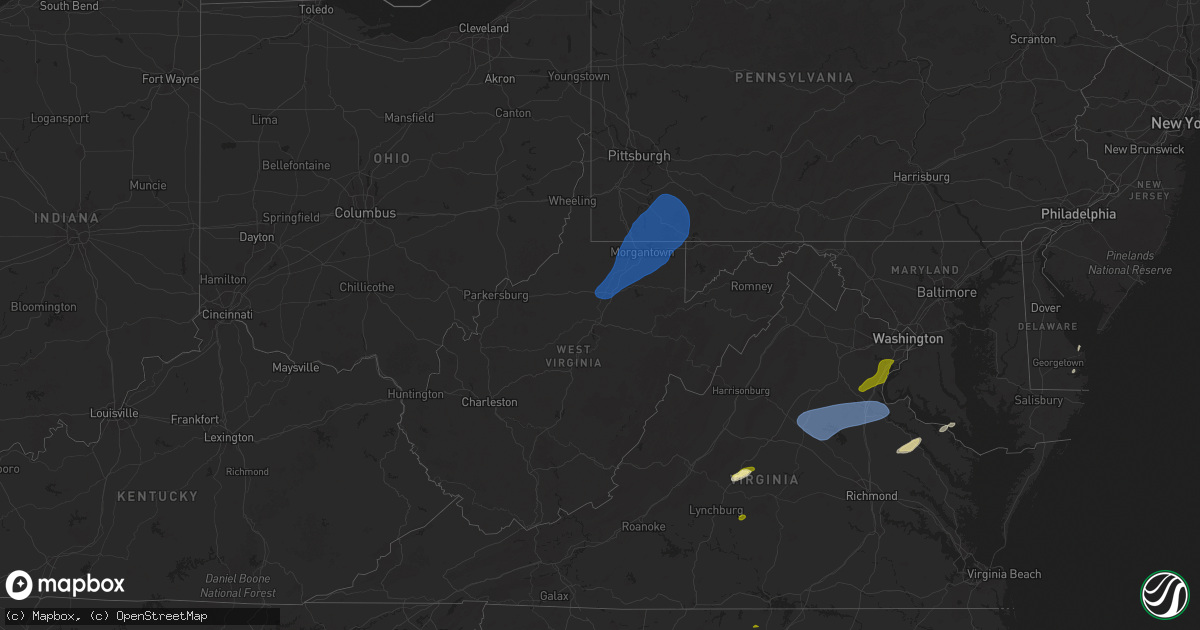
Hail Map in West Virginia on December 31, 2024
Get this storm
December 31 map
$229
one time, instant access
Download today. No call, no setup
Keep the $229
Bought the map and want the full workflow? Apply the entire $229 to a subscription within 7 days. None of it is wasted.
Every map, not just this one
This buys you this map. Subscription and you get every map we run, in the markets you choose from a few cities to whole states to nationwide. Plus real-time alerts the moment a storm fires.
Contact data
Name, contact info, occupancy, even credit band for addresses in the footprint. You go from where it hit to who to call.
Become the source they trust
Unlimited branding weather history reports on demand. You already have the documented answer ready for the property owner, and you are the one who showed up with it.
Property data and RoofTrace estimates
Pull up any address you have got, its value and the exact code rules for that jurisdiction, straight from One Click Code. Then RoofTrace estimates the squares, pitch, and roof value, priced the way you price.
Storm reports in West Virginia
West Virginia
| Date | Description |
|---|---|
| 12/31/20242:07 PM CST | Quarter size hail observed along taylor knob road in frametown. |
| 12/31/20241:20 PM CST | Tree down along old elkins road. |
| 12/31/20241:15 PM CST | A local report indicates 63 MPH wind near Morgantown Airport |
| 12/31/20241:05 PM CST | A few reports of wires down in the area of morgantown. Time estimated. |
| 12/31/20241:04 PM CST | Tree down along mountainview road. Time estimated. |
| 12/31/20241:03 PM CST | Siding damage to a home... And one tree snapped. Time estimated. |
| 12/31/20241:02 PM CST | Tree and wires down... With the tree falling into a structure. |
| 12/31/20241:02 PM CST | Tree down on meadowview lane. Time estimated. |
| 12/31/202412:51 PM CST | Three trees were blown down onto huff creek highway... Blocking the roadway. |
| 12/31/202412:46 PM CST | Small branches down. |
| 12/31/202412:38 PM CST | A small carport awning was lifted off the lot of leesons import motors... Inc along west main street/northwestern turnpike and blown into the sign for bridgeport physic |
| 12/31/202412:38 PM CST | Damage to several structures in the area of fleming avenue. One mobile home lost half of its roof... Antoher home lost a porch roof... And a small metal outbuilding was |
| 12/31/202412:36 PM CST | Tree and wires down blocking the roadway. Time estimated. |
| 12/31/202412:36 PM CST | Large tree and power lines down... Blocking traffic. Time estimated. |
| 12/31/202412:35 PM CST | Tree down with lines on sunset drive. Time estimated. |
| 12/31/202412:35 PM CST | Large tree down on beaumont drive. |
| 12/31/202412:35 PM CST | Power lines down along west main street. Time estimated from radar. |
| 12/31/202412:33 PM CST | A tree was blown down at the intersection of weberwood drive and geary road near the south charleston fire department. |
| 12/31/202412:30 PM CST | Tree down along liberty avenue and gregorys run road. Time estimated from radar. |
| 12/31/202412:25 PM CST | Roof damage to a home along down bridge road with nearby tree and power line damage as well. Measured a 56 mph wind gust at the time of damage. |
| 12/31/202412:24 PM CST | Tree down. |
| 12/31/202412:21 PM CST | Power lines down on robinson mine road and tree down on main street. Time estimated from radar. |
All States Impacted by Hail Map on December 31, 2024
Cities Impacted by Hail Map on December 31, 2024
- Arrington, VA
- Lovingston, VA
- Shipman, VA
- Salem, WV
- Clarksburg, WV
- Lumberport, WV
- Wallace, WV
- Shinnston, WV
- Hepzibah, WV
- Spelter, WV
- Bridgeport, WV
- Meadowbrook, WV
- Enterprise, WV
- Mount Clare, WV
- Anmoore, WV
- Fairmont, WV
- Grafton, WV
- Flemington, WV
- Worthington, WV
- Carolina, WV
- Barrackville, WV
- Farmington, WV
- Baxter, WV
- Rivesville, WV
- Fairview, WV
- Montana Mines, WV
- Maidsville, WV
- Morgantown, WV
- Granville, WV
- Pursglove, WV
- Osage, WV
- Masontown, WV
- Reedsville, WV
- Independence, WV
- Newburg, WV
- Kingwood, WV
- Albright, WV
- Arthurdale, WV
- Bruceton Mills, WV
- Bretz, WV
- Gibbon Glade, PA
- Dilliner, PA
- Farmington, PA
- Markleysburg, PA
- Point Marion, PA
- Lake Lynn, PA
- Garards Fort, PA
- Masontown, PA
- Carmichaels, PA
- New Geneva, PA
- Bobtown, PA
- Greensboro, PA
- Waynesburg, PA
- Mount Morris, PA
- Martin, PA
- Smithfield, PA
- Fairchance, PA
- Uniontown, PA
- Ohiopyle, PA
- Keisterville, PA
- Oliver, PA
- Lemont Furnace, PA
- Uledi, PA
- Fairbank, PA
- Chalk Hill, PA
- Ronco, PA
- Dunbar, PA
- Smock, PA
- Brownfield, PA
- New Salem, PA
- Adah, PA
- Republic, PA
- McClellandtown, PA
- Nemacolin, PA
- Hopwood, PA
- Waltersburg, PA
- Merrittstown, PA
- Allison, PA
- Brownsville, PA
- Grindstone, PA
- Rices Landing, PA
- Cardale, PA
- East Millsboro, PA
- Mount Braddock, PA
- Star Junction, PA
- Perryopolis, PA
- West Leisenring, PA
- Vanderbilt, PA
- Confluence, PA
- Dickerson Run, PA
- Connellsville, PA
- Mill Run, PA
- Normalville, PA
- Dawson, PA
- Scottdale, PA
- Smithton, PA
- White, PA
- Everson, PA
- Schuyler, VA
- Somerset, VA
- Orange, VA
- Gordonsville, VA
- Louisa, VA
- Unionville, VA
- Mineral, VA
- Bumpass, VA
- Spotsylvania, VA
- Rapidan, VA
- Locust Grove, VA
- Rhoadesville, VA
- Culpeper, VA
- Partlow, VA
- Fredericksburg, VA
- Port Royal, VA
- Woodford, VA
- King George, VA
- Stafford, VA
- Quantico, VA
- Triangle, VA
- Nanjemoy, MD
- Dumfries, VA
- Woodbridge, VA
- Lorton, VA
- Occoquan, VA
- Fort Belvoir, VA
- Fairfax Station, VA
- Rappahannock Academy, VA
- Newtown, VA
- Tappahannock, VA
- Saint Stephens Church, VA
- Champlain, VA
- Milford, VA
- Warsaw, VA
- Hague, VA
- Montross, VA
- Piney Point, MD
- Valley Lee, MD
- Tall Timbers, MD
- Lewes, DE
- Centreville, MD
- Queen Anne, MD
- Maidens, VA
- Amherst, VA
- Appomattox, VA
- Millsboro, DE
- Oxford, NC


