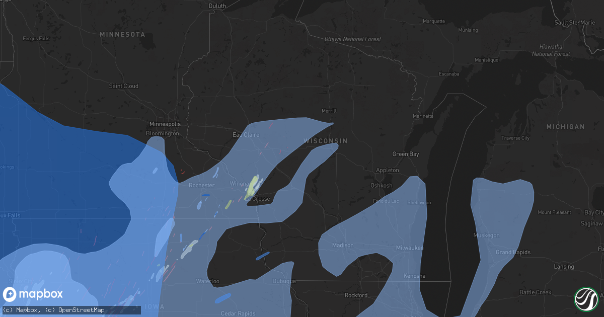
Hail Map in Wisconsin on December 15, 2021
Get this storm
December 15 map
$229
one time, instant access
Download today. No call, no setup
Keep the $229
Bought the map and want the full workflow? Apply the entire $229 to a subscription within 7 days. None of it is wasted.
Every map, not just this one
This buys you this map. Subscription and you get every map we run, in the markets you choose from a few cities to whole states to nationwide. Plus real-time alerts the moment a storm fires.
Contact data
Name, contact info, occupancy, even credit band for addresses in the footprint. You go from where it hit to who to call.
Become the source they trust
Unlimited branding weather history reports on demand. You already have the documented answer ready for the property owner, and you are the one who showed up with it.
Property data and RoofTrace estimates
Pull up any address you have got, its value and the exact code rules for that jurisdiction, straight from One Click Code. Then RoofTrace estimates the squares, pitch, and roof value, priced the way you price.
Storm reports in Wisconsin
Wisconsin
| Date | Description |
|---|---|
| 12/15/20214:45 AM CST | At 1045 PM CST, severe thunderstorms were located along a line extending from 10 miles northeast of Parrish to near Veterans Memorial County Park to 10 miles north of Wittenberg to 10 miles south of Bevent, moving northeast at 65 mph. HAZARD...70 mph wind gusts. SOURCE...Radar indicated. IMPACT...Expect considerable tree damage. Damage is likely to mobile homes, roofs, and outbuildings. Severe thunderstorms will be near... Antigo and Veterans Memorial County Park around 1050 PM CST. Ma Ka Ja Wan Scout Reservation and Pearson around 1055 PM CST. Crandon, Woodlawn and Neopit around 1100 PM CST. White Lake around 1105 PM CST.Other locations in the path of these severe thunderstorms includeGardner Dam Scout Camp, Mountain, Keshena, McCaslin Mountain NaturalArea, Big Smokey Falls, South Branch and Legend Lake. |
| 12/15/20214:17 AM CST | At 1016 PM CST, severe thunderstorms were located along a line extending from near Winslow to near Shannon, moving east at 50 mph. HAZARD...60 mph wind gusts. SOURCE...Radar indicated. IMPACT...Expect damage to roofs, siding, and trees. Severe thunderstorms will be near... Freeport around 1025 PM CST. German Valley around 1030 PM CST. Ridott around 1035 PM CST. |
| 12/15/20213:55 AM CST | At 954 PM CST, severe thunderstorms were located along a line extending from near Rib Lake to 15 miles east of Colby to near Babcock to near New Lisbon, moving northeast at 60 mph. HAZARD...70 mph wind gusts. SOURCE...Radar indicated. IMPACT...Expect considerable tree damage. Damage is likely to mobile homes, roofs, and outbuildings. Severe thunderstorms will be near... New Wood Wildlife Area around 1005 PM CST. Wausau, Wisconsin Rapids, Lake Wazeecha and Tripoli around 1010 PM CST.Other locations in the path of these severe thunderstorms include RibMountain, Tomahawk, Gilbert, Stevens Point, Whiting, Dutch Corners,Plainfield, Veterans Memorial County Park and Amherst. |
| 12/15/20213:45 AM CST | At 944 PM CST, severe thunderstorms were located along a line extending from near Benton to near Burgess, moving northeast at 55 mph. HAZARD...70 mph wind gusts. SOURCE...Radar indicated. IMPACT...Expect considerable tree damage. Damage is likely to mobile homes, roofs, and outbuildings. Severe thunderstorms will be near... Scales Mound around 950 PM CST. Apple River around 955 PM CST. Woodhull around 1000 PM CST.Other locations in the path of these severe thunderstorms includeAndover, Lynn Center, Cambridge, Kewanee, Atkinson, Annawan,Sheffield and Buda. |
| 12/15/20213:33 AM CST | At 933 PM CST, severe thunderstorms were located along a line extending from 11 miles west of Babcock to near Muscoda, moving northeast at 60 mph. HAZARD...60 mph wind gusts. SOURCE...Radar indicated. IMPACT...Expect damage to roofs, siding, and trees. These severe thunderstorms will remain over mainly rural areas of Juneau and Adams Counties, including the following locations... Johnson Hill, Big Spring and Highway 13 And County E.This includes Interstate 90/94 between mile markers 53 and 86. |
| 12/15/20213:28 AM CST | At 928 PM CST, severe thunderstorms were located along a line extending from near Thorp to near Loyal, moving northeast at 60 mph. HAZARD...60 mph wind gusts. SOURCE...Radar indicated. IMPACT...Expect damage to roofs, siding, and trees. Severe thunderstorms will be near... Colby around 935 PM CST. Abbotsford and Dorchester around 940 PM CST.Other locations impacted by these severe thunderstorms include CountyK And Capital Road, Curtiss, Sterling Avenue And Starks Road, Colby,Atwood, Withee and County O And Sterling Avenue. |
| 12/15/20213:28 AM CST | At 927 PM CST, severe thunderstorms were located along a line extending from near Tomah to 10 miles north of Boscobel to near Canton, moving northeast at 75 mph. HAZARD...60 mph wind gusts. SOURCE...Radar indicated. IMPACT...Expect damage to roofs, siding, and trees. Locations impacted include... Baraboo, Reedsburg, Dodgeville, Prairie Du Sac, Sauk City, Wisconsin Dells, Mineral Point, Darlington, Lake Delton, Spring Green, West Baraboo, Shullsburg, Belmont, Benton, Argyle, Blanchardville, Barneveld, Wiota, Highland and Arena. |
| 12/15/20213:17 AM CST | At 917 PM CST, severe thunderstorms were located along a line extending from near Cornell to 6 miles south of Loyal, moving northeast at 80 mph. HAZARD...60 mph wind gusts. SOURCE...Radar indicated. IMPACT...Expect damage to roofs, siding, and trees. Severe thunderstorms will be near... Rib Lake around 955 PM CST.Other locations impacted by these severe thunderstorms include WoodLake, Polley, The Mondeaux Flowage, Highway 13 And County Road M,Stetsonville, Perkinstown and County Roads A And E. |
| 12/15/20213:12 AM CST | At 911 PM CST, severe thunderstorms were located along a line extending from Balltown to near Fruitland, moving east at 55 mph. HAZARD...70 mph wind gusts. SOURCE...Radar indicated. IMPACT...Expect considerable tree damage. Damage is likely to mobile homes, roofs, and outbuildings. Severe thunderstorms will be near... Rickardsville, Sherrill and Balltown around 915 PM CST. Fairport and Illinois City around 930 PM CST.Other locations in the path of these severe thunderstorms includeBlue Grass, Andalusia, Taylor Ridge, Buffalo, Rock Island, Milan, OakGrove, Moline, Bettendorf, Riverdale, East Moline, Silvis, Colona,Coal Valley, Hampton, Le Claire, Port Byron, Rapids City, Clevelandand Osborn. |
| 12/15/20213:10 AM CST | At 910 PM CST, severe thunderstorms were located along a line extending from near New Auburn to 6 miles northwest of Cadott to 7 miles northeast of Fairchild, moving northeast at 70 mph. HAZARD...60 mph wind gusts. SOURCE...Radar indicated. IMPACT...Expect damage to roofs, siding, and trees. Severe thunderstorms will be near... Cornell around 920 PM CST. Weyerhaeuser around 925 PM CST. Bruce and Sheldon around 930 PM CST.Other locations in the path of these severe thunderstorms includeHawkins. |
| 12/15/20213:06 AM CST | At 905 PM CST, severe thunderstorms were located along a line extending from near Augusta to near Hatfield to Westby, moving northeast at 70 mph. HAZARD...70 mph wind gusts and quarter size hail. SOURCE...Radar indicated. IMPACT...Hail damage to vehicles is expected. Expect considerable tree damage. Wind damage is also likely to mobile homes, roofs, and outbuildings. Locations impacted include... Marshfield, Spencer, Abbotsford, Babcock and Pittsville. |
| 12/15/20213:05 AM CST | At 904 PM CST, severe thunderstorms were located along a line extending from near Bloomer to 7 miles south of Stanley to near Neillsville, moving northeast at 75 mph. HAZARD...60 mph wind gusts. SOURCE...Radar indicated. IMPACT...Expect damage to roofs, siding, and trees. Severe thunderstorms will be near... Thorp around 910 PM CST. Colby around 930 PM CST.Other locations impacted by these severe thunderstorms include CountyK And Capital Road, Mead Lake, Atwood, County O And Sterling Avenue,Eidsvold, Longwood and Curtiss. |
| 12/15/20212:31 AM CST | At 830 PM CST, severe thunderstorms were located along a line extending from near Eau Galle to 9 miles west of Independence to near Galesville, moving northeast at 65 mph. HAZARD...60 mph wind gusts. SOURCE...Radar indicated. IMPACT...Expect damage to roofs, siding, and trees. Severe thunderstorms will be near... Menomonie around 845 PM CST. Elk Mound around 850 PM CST.Other locations in the path of these severe thunderstorms includeColfax, Augusta, Fall Creek, Bloomer and Boyd. |
| 12/15/20212:24 AM CST | At 823 PM CST, severe thunderstorms were located along a line extending from 6 miles northwest of Modena to Galesville to 6 miles southwest of Stoddard, moving northeast at 75 mph. THESE ARE DESTRUCTIVE STORMS. HAZARD...80 mph wind gusts. SOURCE...Radar indicated. IMPACT...Flying debris will be dangerous to those caught without shelter. Mobile homes will be heavily damaged. Expect considerable damage to roofs, windows, and vehicles. Extensive tree damage and power outages are likely. Severe thunderstorms will be near... Coon Valley around 835 PM CST. West Salem around 840 PM CST. Bangor around 845 PM CST. Sparta around 850 PM CST. |
| 12/15/20212:09 AM CST | At 809 PM CST, severe thunderstorms were located along a line extending from near Prescott to near Bay City to near Pepin, moving northeast at 55 mph. HAZARD...60 mph wind gusts. SOURCE...Radar indicated. IMPACT...Expect damage to roofs, siding, and trees. Severe thunderstorms will be near... Pepin around 815 PM CST. Plum City around 820 PM CST. Durand and Elmwood around 825 PM CST.Other locations in the path of these severe thunderstorms includeBaldwin, Hammond, Eau Galle, Woodville, Menomonie, Glenwood City,Boyceville and Elk Mound. |
| 12/15/20211:48 AM CST | At 747 PM CST, severe thunderstorms were located along a line extending from near Webster to Kenyon to near Dodge Center, moving northeast at 50 mph. HAZARD...60 mph wind gusts. SOURCE...Radar indicated. IMPACT...Expect damage to roofs, siding, and trees. Severe thunderstorms will be near... Wanamingo around 755 PM CST. Pine Island around 805 PM CST.Other locations in the path of these severe thunderstorms includeGoodhue, Welch and Red Wing. |
| 12/14/202111:05 PM CST | Report from mping: 3-inch tree limbs broken; power poles broken. |
| 12/14/202110:50 PM CST | Report from mping. |
| 12/14/202110:50 PM CST | Power lines and trees down. Damage and power outages were reported along highway 8 from near crescent to pelican lake. |
| 12/14/202110:25 PM CST | Shingle and siding damage to home. Time estimated by radar. |
| 12/14/202110:23 PM CST | Several trees and power poles/lines down on county rd p at county rd j. Social media report from wsaw-tv. Time estimated. |
| 12/14/202110:14 PM CST | A local report indicates 69 MPH wind near WISCONSIN RAPIDS |
| 12/14/202110:10 PM CST | Several trees down in marathon city |
| 12/14/202110:10 PM CST | Tree fell through roof of house in town of stella. |
| 12/14/202110:10 PM CST | Power lines down in rewey... Dodgeville and cobb. Power out in barneveld. |
| 12/14/202110:06 PM CST | Report from mping: homes/buildings completely destroyed. |
| 12/14/202110:02 PM CST | Corrects previous tstm wnd gst report from lone rock. |
| 12/14/202110:02 PM CST | A local report indicates 76 MPH wind near LONE ROCK |
| 12/14/20219:55 PM CST | A local report indicates 68 MPH wind near PLATTEVILLE |
| 12/14/20219:55 PM CST | A local report indicates 62 MPH wind near LONE ROCK |
| 12/14/20219:55 PM CST | A local report indicates 62 MPH wind near 7 WNW SPRING GREEN |
| 12/14/20219:50 PM CST | Many trees and power lines reported down across the county... Especially the southern half. |
| 12/14/20219:44 PM CST | Several trees blown down |
| 12/14/20219:44 PM CST | Several trees blown down. |
| 12/14/20219:37 PM CST | Tree damage. Social media report from wsaw-tv |
| 12/14/20219:35 PM CST | A local report indicates 60 MPH wind near PLATTEVILLE |
| 12/14/20219:34 PM CST | A local report indicates 60 MPH wind near DICKEYVILLE |
| 12/14/20219:32 PM CST | A local report indicates 62 MPH wind near 2 N VIOLA |
| 12/14/20219:30 PM CST | Power lines blown down. |
| 12/14/20219:30 PM CST | Power lines blown down |
| 12/14/20219:28 PM CST | Multiple large trees were uprooted and fell on structures and vehicles in tomah. One caused a gas line rupture. Many other reports of trees and power lines down across |
| 12/14/20219:24 PM CST | Trees and power lines down across roads... Debris from damage roof. |
| 12/14/20219:24 PM CST | 18 inch diameter pine tree down. Time estimated from radar. |
| 12/14/20219:21 PM CST | Photos relayed by local tv meteorologist of large pine trees down from the main storm. Time estimated by radar. |
| 12/14/20219:21 PM CST | Power lines across road... Tree damage... Debris from damaged roof. |
| 12/14/20219:19 PM CST | Windows blown out... Roofs removed from sheds. |
| 12/14/20219:18 PM CST | Reports of multiple trees down and damage to structures per stanley police department facebook page. Time estimated from radar. |
| 12/14/20219:15 PM CST | A local report indicates 62 MPH wind near 5 S VIROQUA |
| 12/14/20219:15 PM CST | A local report indicates 70 MPH wind near LONGWOOD |
| 12/14/20219:15 PM CST | A local report indicates 69 MPH wind near VIROQUA |
| 12/14/20219:11 PM CST | Door overhands damaged. |
| 12/14/20219:11 PM CST | Door overhands damaged |
| 12/14/20219:03 PM CST | A local report indicates 63 MPH wind near BAGLEY |
| 12/14/20219:00 PM CST | Official wind gust observation from keau. |
| 12/14/20218:51 PM CST | House damaged |
| 12/14/20218:51 PM CST | House damaged. |
| 12/14/20218:51 PM CST | Trees down. |
| 12/14/20218:50 PM CST | Report of multiple branches down... Hard to determine size in the darkness. |
| 12/14/20218:47 PM CST | Reports of trees down within town. |
| 12/14/20218:45 PM CST | Reports of few trees down in town. |
| 12/14/20218:30 PM CST | A local report indicates 1.25 inch wind near 4 NE NEW AMSTERDAM |
| 12/14/20218:26 PM CST | Mesonet station fw3090 trempealeau. |
| 12/14/20218:20 PM CST | Considerable number of trees blown down in the trempealeau wildlife refuge. Estimates of 50 to 100 in the vicinity of the visitors center alone. |
| 12/14/20218:20 PM CST | Power lines down. |
All States Impacted by Hail Map on December 15, 2021
Cities Impacted by Hail Map on December 15, 2021
- Nowata, OK
- Delaware, OK
- Americus, KS
- Emporia, KS
- Uniontown, KS
- Redfield, KS
- Whitewater, KS
- Newton, KS
- Mapleton, KS
- Fort Scott, KS
- Moran, KS
- Fulton, KS
- Bronson, KS
- Odebolt, IA
- Holmen, WI
- Axtell, KS
- Pawnee City, NE
- Burchard, NE
- Plattsmouth, NE
- Pacific Junction, IA
- Glenwood, IA
- Murray, NE
- Savonburg, KS
- Fall River, KS
- Fredonia, KS
- Toronto, KS
- Saint Edward, NE
- Fullerton, NE
- Belgrade, NE
- Oakland, IA
- Carson, IA
- Onaga, KS
- Ayr, NE
- Hastings, NE
- Avoca, NE
- Weeping Water, NE
- Elmwood, NE
- Neodesha, KS
- Ottawa, KS
- Onalaska, WI
- Burns, KS
- Osceola, NE
- Giltner, NE
- Hordville, NE
- Marquette, NE
- Stromsburg, NE
- Phillips, NE
- Polk, NE
- Aurora, NE
- Doniphan, NE
- Silver Creek, NE
- Clarks, NE
- Ogden, IA
- Milford, NE
- Dorchester, NE
- Winfield, KS
- Stark, KS
- Prague, NE
- Bruno, NE
- Springfield, NE
- Eagle, NE
- Gretna, NE
- Papillion, NE
- Murdock, NE
- Omaha, NE
- Louisville, NE
- Alvo, NE
- Ashland, NE
- Elk City, KS
- Olpe, KS
- Strong City, KS
- Greenwood, NE
- Pleasant Dale, NE
- Lincoln, NE
- Friend, NE
- Leigh, NE
- Monroe, NE
- Duncan, NE
- Hampton, NE
- Trumbull, NE
- Clarkson, NE
- Shelby, NE
- Columbus, NE
- Arcadia, KS
- Walnut, KS
- Bronaugh, MO
- Erie, KS
- Saint Paul, KS
- Farlington, KS
- Girard, KS
- Liberal, MO
- Hepler, KS
- Morrowville, KS
- Clifton, KS
- Mound City, MO
- Skidmore, MO
- Barnard, MO
- Ravenwood, MO
- Maryville, MO
- Graham, MO
- Maitland, MO
- Clyde, MO
- Conception Junction, MO
- Pierson, IA
- Bronson, IA
- Hornick, IA
- Climbing Hill, IA
- Sloan, IA
- Correctionville, IA
- Kingsley, IA
- Moville, IA
- Anthon, IA
- Salix, IA
- Jefferson, IA
- Augusta, KS
- Bartlesville, OK
- Nehawka, NE
- Carroll, IA
- Scranton, IA
- Cambridge, KS
- Latham, KS
- Burden, KS
- Atlanta, KS
- Trempealeau, WI
- Galesville, WI
- Dakota, MN
- Roseland, NE
- Bladen, NE
- Linn, KS
- Agenda, KS
- Concordia, KS
- Washington, KS
- Clyde, KS
- Hollenberg, KS
- Haddam, KS
- Missouri Valley, IA
- Humboldt, KS
- La Harpe, KS
- Iola, KS
- Yates Center, KS
- Coon Rapids, IA
- Exira, IA
- Hamlin, IA
- Syracuse, NE
- Vassar, KS
- Neosho Rapids, KS
- Lebo, KS
- New Century, KS
- Pomona, KS
- Quenemo, KS
- Wellsville, KS
- Gardner, KS
- Eudora, KS
- Cedar Point, KS
- Lyndon, KS
- Osage City, KS
- Edgerton, KS
- Reading, KS
- Olathe, KS
- Melvern, KS
- Cottonwood Falls, KS
- Baldwin City, KS
- Bennet, NE
- Nebraska City, NE
- Macedonia, IA
- Marne, IA
- Union, NE
- Hancock, IA
- Hastings, IA
- Treynor, IA
- Brayton, IA
- Silver City, IA
- Unadilla, NE
- Council Bluffs, IA
- Mineola, IA
- Offutt Afb, NE
- Dunbar, NE
- Walnut, IA
- Elk Horn, IA
- Bellevue, NE
- Guthrie Center, IA
- Malvern, IA
- Palmyra, NE
- Otoe, NE
- Henderson, IA
- Audubon, IA
- Atlantic, IA
- Bayard, IA
- Edgar, NE
- Williams, IA
- Blairsburg, IA
- David City, NE
- Richards, MO
- Ithaca, NE
- Lincolnville, KS
- Madison, KS
- Palmer, NE
- Essex, IA
- Buffalo, KS
- Fort Calhoun, NE
- Iowa Falls, IA
- Popejoy, IA
- Dows, IA
- Alden, IA
- Hampton, IA
- Filley, NE
- Beatrice, NE
- Blue Springs, NE
- Steele City, NE
- Fairbury, NE
- Belleville, KS
- Odell, NE
- Cuba, KS
- Diller, NE
- Hanover, KS
- Wymore, NE
- Endicott, NE
- Mahaska, KS
- Hooper, NE
- Cedar Bluffs, NE
- Ames, NE
- Fremont, NE
- Onawa, IA
- Whiting, IA
- Decatur, NE
- Macy, NE
- Thayer, KS
- Arma, KS
- Galesburg, KS
- Piedmont, KS
- Severy, KS
- Washta, IA
- Quimby, IA
- Ettrick, WI
- Winona, MN
- La Crescent, MN
- Brainard, NE
- Boone, IA
- Stratford, IA
- Pilot Mound, IA
- Schuyler, NE
- Howard, KS
- Grenola, KS
- Longton, KS
- Moline, KS
- Rock, KS
- Juniata, NE
- Holton, KS
- Waverly, KS
- Dexter, KS
- Burlington, KS
- Hartford, KS
- Talmage, NE
- Powhattan, KS
- Hiawatha, KS
- Salina, KS
- Assaria, KS
- Gypsum, KS
- Solomon, KS
- Chanute, KS
- Bellwood, NE
- Rising City, NE
- Cherryvale, KS
- Dennis, KS
- Parsons, KS
- Havana, KS
- Sedan, KS
- Independence, KS
- Elk Falls, KS
- West Point, NE
- Garnett, KS
- Williamsburg, KS
- White Cloud, KS
- Craig, MO
- Dodge, NE
- Greene, IA
- Charles City, IA
- Marble Rock, IA
- Bristow, IA
- Palmer, KS
- Waverly, NE
- Ceresco, NE
- Bancroft, NE
- Parnell, MO
- Sheridan, MO
- Stanberry, MO
- Walker, MO
- Nevada, MO
- Fort Leavenworth, KS
- Gridley, KS
- Vinita, OK
- Clay Center, KS
- Morganville, KS
- Miltonvale, KS
- Wetmore, KS
- Netawaka, KS
- Grand Island, NE
- Howells, NE
- Saint Paul, NE
- Elsmore, KS
- Scribner, NE
- Havensville, KS
- Admire, KS
- Summerfield, KS
- Nemaha, NE
- Brownville, NE
- Baileyville, KS
- Humboldt, NE
- Table Rock, NE
- Auburn, NE
- Raymond, NE
- Leon, KS
- Aredale, IA
- Rose Hill, KS
- Tobias, NE
- Rogers, NE
- Burr, NE
- Douglas, NE
- Martell, NE
- Crete, NE
- Rodney, IA
- Smithland, IA
- Barnsdall, OK
- Ochelata, OK
- Chapman, NE
- Malcolm, NE
- Davey, NE
- Firth, NE
- Panama, NE
- Hickman, NE
- Adams, NE
- Pickrell, NE
- Panora, IA
- Bagley, IA
- Yale, IA
- Jamaica, IA
- Central City, NE
- Dayton, IA
- Wisner, NE
- Beemer, NE
- Sergeant Bluff, IA
- Goff, KS
- Bennington, NE
- Waterloo, NE
- Elkhorn, NE
- Benedict, NE
- Barnes, KS
- Greenleaf, KS
- Mead, NE
- Yutan, NE
- Stanhope, IA
- Boxholm, IA
- Paton, IA
- York, NE
- Hubbell, NE
- Munden, KS
- Narka, KS
- Melrose, WI
- Derby, KS
- Andover, KS
- Wichita, KS
- Virginia, NE
- Crab Orchard, NE
- Linwood, NE
- Sterling, NE
- Roca, NE
- Horton, KS
- Robinson, KS
- Bolckow, MO
- Forest City, MO
- Oregon, MO
- Grand Junction, IA
- Dana, IA
- Rippey, IA
- North Bend, NE
- Morse Bluff, NE
- Manley, NE
- Charter Oak, IA
- Grimes, IA
- Verdigre, NE
- Milton, KS
- Surprise, NE
- Bondurant, IA
- Counselor, NM
- Pemberton, MN
- Wallingford, IA
- Randall, KS
- Pritchett, CO
- Center, CO
- Vernon Center, MN
- Offerle, KS
- Oberlin, KS
- Branson, CO
- Downs, KS
- Wilsey, KS
- Maybell, CO
- Happy, TX
- Halbur, IA
- Durango, CO
- Barnum, IA
- White River, SD
- Fort Garland, CO
- Tierra Amarilla, NM
- Pierre, SD
- Fulton, SD
- San Jon, NM
- Weldon, IA
- White Owl, SD
- Thoreau, NM
- Danville, KS
- Wentworth, SD
- Bristow, NE
- Rainsville, NM
- Minneota, MN
- Amalia, NM
- Malmo, NE
- Cunningham, KS
- Soldier, IA
- Cimarron, KS
- Hillsboro, KS
- Revere, MN
- Lineville, IA
- Rosalia, KS
- Casa Blanca, NM
- Tabor, IA
- Idaho Springs, CO
- Magnet, NE
- Harveyville, KS
- Box Elder, SD
- Merna, NE
- Calumet, IA
- Presho, SD
- Scotia, NE
- Albin, WY
- Lost Springs, WY
- Meservey, IA
- Haysville, KS
- Storden, MN
- Breckenridge, MO
- Childress, TX
- Independence, MO
- Canjilon, NM
- Springlake, TX
- Swink, CO
- Drummond, OK
- Placitas, NM
- Lyman, NE
- Jamestown, KS
- Solano, NM
- Oakdale, NE
- Pisgah, IA
- Pratt, KS
- Fairview, KS
- Platte, SD
- Missouri City, MO
- Webster, MN
- Coaldale, CO
- Burlington, CO
- Rockwell, IA
- Truesdale, IA
- Leavenworth, KS
- Cherokee, IA
- Plankinton, SD
- Bryant, SD
- Naponee, NE
- Laurens, IA
- Bruce, SD
- Turon, KS
- Warner, SD
- Martensdale, IA
- Bogue, KS
- Alva, OK
- Arnolds Park, IA
- Cologne, MN
- Pukwana, SD
- Hobbs, NM
- Corning, IA
- Pueblo, CO
- Grant City, MO
- Lake View, IA
- Hardy, IA
- Morland, KS
- Dexter, IA
- Cedaredge, CO
- Oklahoma City, OK
- Glencoe, MN
- Yampa, CO
- Effingham, KS
- Dolliver, IA
- Longford, KS
- Vaughn, NM
- Logan, IA
- Vega, TX
- Wiggins, CO
- Lodgepole, SD
- Orchard, CO
- Blooming Prairie, MN
- Halstead, KS
- Northville, SD
- Chester, OK
- Olney Springs, CO
- Mapleton, IA
- McCracken, KS
- Vinson, OK
- Matador, TX
- Flagler, CO
- Allenspark, CO
- Taloga, OK
- Kenyon, MN
- Hospers, IA
- Watertown, SD
- Colton, SD
- Bloomfield, NM
- Fort Sumner, NM
- Jamestown, NM
- Clinton, MN
- Hanston, KS
- Wilmore, KS
- Okarche, OK
- Coin, IA
- Odessa, MN
- Madison, MN
- Alcester, SD
- Buena Vista, NM
- Lonsdale, MN
- Steen, MN
- Guernsey, WY
- Kensington, KS
- Bethune, CO
- Martin, SD
- Harrisburg, SD
- Allerton, IA
- Emmet, NE
- Colon, NE
- Mitchell, NE
- Dulce, NM
- Enders, NE
- Wayne, NE
- Central City, CO
- North Loup, NE
- Roxbury, KS
- Lorimor, IA
- Milbank, SD
- Blockton, IA
- Rockham, SD
- Nekoma, KS
- Weston, NE
- Lockney, TX
- Rexford, KS
- Herndon, KS
- Elysian, MN
- Kersey, CO
- Guymon, OK
- Molina, CO
- Claflin, KS
- Satanta, KS
- Gilbert, IA
- Hills, MN
- Granada, MN
- Gibbon, NE
- Lewisville, MN
- Owanka, SD
- Artesian, SD
- Beaver, OK
- Clay Center, NE
- Clearwater, KS
- Carpenter, WY
- Idledale, CO
- Goodwin, SD
- Fort Pierre, SD
- Manly, IA
- Edgerton, MO
- Dearborn, MO
- Simpson, KS
- Jewell, IA
- Dunnell, MN
- Hitchcock, SD
- Murray, IA
- Quanah, TX
- Darfur, MN
- Quitaque, TX
- Rociada, NM
- Gateway, CO
- Miller, SD
- Poncha Springs, CO
- Marion, SD
- Warsaw, MN
- Blackwell, OK
- Atlanta, NE
- Mora, NM
- Nunn, CO
- Vivian, SD
- Fairburn, SD
- Ringwood, OK
- Byers, KS
- Blencoe, IA
- Booneville, IA
- Enning, SD
- Wallace, NE
- Spencer, IA
- Hugoton, KS
- Palco, KS
- Mercer, MO
- Oneida, KS
- Omega, OK
- Superior, NE
- Waubay, SD
- Vona, CO
- Mount Hope, KS
- Newman Grove, NE
- Memphis, TX
- Dresden, KS
- Lu Verne, IA
- Mason City, NE
- Latimer, IA
- Valmora, NM
- Denison, KS
- De Witt, NE
- Ness City, KS
- Steinauer, NE
- Morgan, MN
- Silver Lake, KS
- Titonka, IA
- Wolfforth, TX
- Nicollet, MN
- Delphos, KS
- Parmelee, SD
- South Haven, KS
- Crookston, NE
- Farley, MO
- Phippsburg, CO
- Parlin, CO
- Alta, IA
- Peru, IA
- Wildorado, TX
- Hershey, NE
- Eagle Grove, IA
- Edgemont, SD
- Romeo, CO
- Boncarbo, CO
- Oldham, SD
- Chillicothe, MO
- Empire, CO
- Freeman, SD
- Scranton, KS
- Granville, IA
- Ridgway, CO
- Chester, SD
- Fonda, IA
- Vadito, NM
- Erick, OK
- Del Norte, CO
- Tatum, NM
- Saint Libory, NE
- Moorland, IA
- Golden, CO
- Rosalie, NE
- Red Feather Lakes, CO
- Winfred, SD
- Ogden, KS
- Thurston, NE
- Binger, OK
- Hinton, IA
- Fordyce, NE
- Orchard, NE
- Deerfield, KS
- Maxwell, NM
- Littleton, CO
- Datil, NM
- Scandia, KS
- Emerson, NE
- Goodland, KS
- Palisade, NE
- Cee Vee, TX
- Osmond, NE
- Wesley, IA
- Mankato, MN
- Ravenna, NE
- Garden Grove, IA
- Oskaloosa, KS
- Foss, OK
- Sheffield, IA
- Lamoni, IA
- Modale, IA
- Holland, MN
- Shubert, NE
- New Underwood, SD
- Maize, KS
- Villisca, IA
- Corydon, IA
- Highland, KS
- Stapleton, NE
- Torreon, NM
- Ellsworth, MN
- Sundown, TX
- Carlsbad, NM
- Minturn, CO
- Ohio City, CO
- Ringsted, IA
- Hardwick, MN
- Bison, OK
- Sanborn, MN
- Lenox, IA
- Parker, KS
- Lakefield, MN
- Western, NE
- Creston, IA
- Canistota, SD
- Oneill, NE
- Frankfort, KS
- Schleswig, IA
- Granite, CO
- Clarksdale, MO
- Encino, NM
- Windsor Heights, IA
- Elbert, CO
- Anton Chico, NM
- Waterbury, NE
- Shambaugh, IA
- Crescent, IA
- Kiowa, KS
- Marienthal, KS
- Westbrook, MN
- Scarville, IA
- Humphrey, NE
- Colony, OK
- Snowmass, CO
- Early, IA
- Weston, MO
- Hagerman, NM
- Canones, NM
- Center, NE
- Interior, SD
- Luther, IA
- San Ysidro, NM
- Sayre, OK
- Sentinel, OK
- Parshall, CO
- Burns, CO
- Crawford, OK
- Gilmore City, IA
- North Sioux City, SD
- Santa Fe, NM
- Canton, OK
- Wamego, KS
- Albany, MO
- Dillon, CO
- Sutherland, IA
- West Des Moines, IA
- Hamilton, KS
- Topeka, KS
- Brookville, KS
- Cedar, KS
- Welda, KS
- Willow Island, NE
- Elsie, NE
- Saint Joseph, MO
- Oelrichs, SD
- Tingley, IA
- Reva, SD
- Fairmont, NE
- Ricketts, IA
- Hartford, SD
- Cheney, KS
- Yoder, WY
- Thurman, IA
- Jackson, NE
- Laramie, WY
- Long Island, KS
- Murdock, KS
- Prairie Village, KS
- Randolph, IA
- Cordova, NM
- Lorraine, KS
- Waseca, MN
- Hollis, OK
- Brownell, KS
- Lebanon, KS
- Burr Oak, KS
- Ashland, KS
- Ireton, IA
- Rozel, KS
- Salem, NE
- Crossroads, NM
- Adrian, TX
- Ottosen, IA
- Bradley, SD
- Johnston, IA
- Imperial, NE
- Basalt, CO
- Dundas, MN
- Callaway, NE
- Ojo Caliente, NM
- Kanopolis, KS
- Oak Grove, MO
- Ellendale, MN
- Peralta, NM
- Peabody, KS
- Clayton, KS
- Beulah, CO
- Sioux Falls, SD
- Berthoud, CO
- Brady, NE
- Evans, CO
- Dow City, IA
- Clatonia, NE
- Garrett, WY
- Lester, IA
- Fairfax, MN
- Albuquerque, NM
- Drake, CO
- Newport, NE
- Pinehill, NM
- Wood Lake, NE
- Fort Morgan, CO
- Fedora, SD
- Gillett Grove, IA
- Lovington, NM
- Mclean, TX
- Duncombe, IA
- Delta, CO
- Blanchard, IA
- Jetmore, KS
- Falun, KS
- Piqua, KS
- Canute, OK
- Harrison, NE
- Lincoln, KS
- Andale, KS
- Hereford, TX
- Lucas, IA
- Clearmont, MO
- Grenville, NM
- Underwood, IA
- Hurley, SD
- Simla, CO
- Du Bois, NE
- Cochiti Pueblo, NM
- Savannah, MO
- Afton, IA
- Darlington, MO
- Portales, NM
- Braddyville, IA
- Oakwood, OK
- Medford, OK
- Bigelow, MN
- San Cristobal, NM
- Bingham Lake, MN
- Oyens, IA
- Cuervo, NM
- De Soto, IA
- La Veta, CO
- Emmons, MN
- Bard, NM
- Waco, NE
- Farragut, IA
- Winterset, IA
- Cook, NE
- Ashton, IA
- Byers, CO
- San Luis, CO
- Volin, SD
- Sheridan Lake, CO
- Deshler, NE
- Knierim, IA
- Aspinwall, IA
- Taiban, NM
- Chappell, NE
- Oxford, NE
- Fostoria, IA
- Pfeifer, KS
- Jordan, MN
- Shawnee, WY
- Bucklin, KS
- Watrous, NM
- Cody, NE
- Bradgate, IA
- Ohkay Owingeh, NM
- Midland, SD
- Kirtland, NM
- Little River, KS
- Windom, KS
- Plains, TX
- Seagraves, TX
- Ree Heights, SD
- Battle Creek, NE
- Trinchera, CO
- Las Vegas, NM
- Lubbock, TX
- Tampa, KS
- Nenzel, NE
- Neola, IA
- Nemo, SD
- Echo, MN
- Canby, MN
- Trenton, MO
- Gresham, NE
- Le Mars, IA
- Panhandle, TX
- Cresbard, SD
- Hanlontown, IA
- Lake City, CO
- Amboy, MN
- Mission, SD
- Cascade, CO
- Stuart, NE
- Harlan, IA
- Hernandez, NM
- Orrick, MO
- Fort Cobb, OK
- Liberal, KS
- Valley Falls, KS
- Logan, KS
- Reliance, SD
- Byron, NE
- Chadron, NE
- Summerfield, TX
- Bovina, TX
- Wolcott, CO
- Belle Plaine, MN
- Otho, IA
- Everly, IA
- Limon, CO
- Chandler, MN
- Seminole, TX
- Tijeras, NM
- Ensign, KS
- Gill, CO
- Torrington, WY
- Shickley, NE
- Pitkin, CO
- Lance Creek, WY
- Mooreland, OK
- Patterson, IA
- Alda, NE
- Hubbard, IA
- Sylvia, KS
- Axtell, NE
- Willow, OK
- Elk Mountain, WY
- Des Moines, IA
- Hugo, CO
- Pleasanton, NE
- Nevada, IA
- Corsica, SD
- Sawyer, KS
- Rapid City, SD
- Lancaster, KS
- Colome, SD
- Cheyenne, OK
- Rush, CO
- Grafton, IA
- Gravity, IA
- Prewitt, NM
- Summit, SD
- Larrabee, IA
- Granada, CO
- Hasty, CO
- Erwin, SD
- Shattuck, OK
- Johnstown, CO
- Cortez, CO
- Protection, KS
- Stilwell, KS
- Holdrege, NE
- Esbon, KS
- Cubero, NM
- Syracuse, KS
- Mcdonald, NM
- Henry, SD
- Shawnee, CO
- Chama, CO
- McDonald, KS
- Freedom, OK
- Rollinsville, CO
- Archer, NE
- Plattsburg, MO
- Hardy, NE
- Forgan, OK
- La Loma, NM
- Coldwater, KS
- Hardin, MO
- Monument, CO
- Hopkins, MO
- El Prado, NM
- Neligh, NE
- Potwin, KS
- Ralls, TX
- Gann Valley, SD
- Hardtner, KS
- Willard, NM
- Wounded Knee, SD
- Union City, OK
- Allen, KS
- Mcalister, NM
- Creighton, NE
- Thor, IA
- Wagner, SD
- Pilger, NE
- Monument, KS
- Lake Arthur, NM
- Colby, KS
- Durham, OK
- Corona, NM
- Benkelman, NE
- Lexington, MO
- Folsom, NM
- Wheatland, WY
- Sutherland, NE
- Rulo, NE
- Potter, NE
- Anita, IA
- Buffalo Center, IA
- Berryton, KS
- Bailey, CO
- Ludell, KS
- Brighton, CO
- Stoneham, CO
- North Newton, KS
- Norwood Young America, MN
- Plainview, TX
- Ayrshire, IA
- Andover, SD
- Mosca, CO
- Wanda, MN
- Maple City, KS
- Ransom, KS
- Edgerton, MN
- College Springs, IA
- Randall, IA
- Garden City, KS
- Kranzburg, SD
- Bellvue, CO
- Dickens, NE
- Pecos, TX
- Ransom Canyon, TX
- Isabel, KS
- Leadville, CO
- Ponderosa, NM
- Lamont, OK
- Burnside, IA
- Delia, KS
- Isleta, NM
- Coleridge, NE
- Lone Jack, MO
- Ansley, NE
- Silverton, TX
- Grain Valley, MO
- Manville, WY
- Madrid, IA
- Garita, NM
- Julian, NE
- Gayville, SD
- Wabasso, MN
- Rolfe, IA
- Catharine, KS
- Linn Grove, IA
- Carr, CO
- Coal Creek, CO
- Winter Park, CO
- Akron, CO
- Holcomb, KS
- Keenesburg, CO
- Rosendale, MO
- Morton, TX
- Mangum, OK
- Hamilton, CO
- Henrietta, MO
- Naper, NE
- Beaumont, KS
- Greenwood, MO
- Agency, MO
- Cleo Springs, OK
- Riverton, NE
- Cotopaxi, CO
- Russell, MN
- Lehigh, IA
- Princeton, KS
- Stinnett, TX
- Lake Benton, MN
- Riley, KS
- San Rafael, NM
- Dodson, TX
- Hanska, MN
- Springfield, SD
- Wanblee, SD
- Hinton, OK
- Towanda, KS
- Blomkest, MN
- Dickens, IA
- Janesville, MN
- Gothenburg, NE
- Walker, KS
- Maple, TX
- Tererro, NM
- Alden, MN
- Clayton, NM
- Minneola, KS
- Cuba, NM
- Elk Creek, NE
- Gregory, SD
- Almena, KS
- Stewart, MN
- Goldfield, IA
- Raymond, KS
- New Prague, MN
- Lenora, KS
- Langford, SD
- Broken Bow, NE
- Camp Crook, SD
- Beresford, SD
- Rosebud, SD
- Turkey, TX
- Inwood, IA
- Shelton, NE
- Orlando, OK
- Medford, MN
- Halsey, NE
- Union Center, SD
- Navajo Dam, NM
- Harvard, NE
- Ellsworth, NE
- Heron Lake, MN
- Quinn, SD
- Fort Laramie, WY
- Camden, MO
- Labolt, SD
- Lennox, SD
- Kirk, CO
- Casey, IA
- Mancos, CO
- Hill City, SD
- Moriarty, NM
- Albert Lea, MN
- Utica, MO
- Hillsdale, WY
- Morrison, OK
- Granger, IA
- Indianola, IA
- Ralph, SD
- Humboldt, SD
- Geneva, MN
- Lamar, CO
- Earlham, IA
- Nash, OK
- Kaw City, OK
- Glen Haven, CO
- New Raymer, CO
- Whitman, NE
- Lakin, KS
- Harcourt, IA
- Elida, NM
- Lamy, NM
- Seward, NE
- Rutland, SD
- Home, KS
- Haswell, CO
- Abernathy, TX
- Ponca, NE
- Masterson, TX
- Geary, OK
- Ainsworth, NE
- Bertrand, NE
- Buckner, MO
- Manilla, IA
- Tahoka, TX
- Inman, NE
- Tracy, MN
- Egnar, CO
- Breda, IA
- Muscotah, KS
- Schaller, IA
- Granite Canon, WY
- Riverton, IA
- Saint Clair, MN
- Wilson, KS
- Merrill, IA
- Marvin, SD
- Milford, IA
- Purdum, NE
- Seibert, CO
- Abbyville, KS
- Courtland, KS
- Taylor, NE
- Macksburg, IA
- Beloit, KS
- Nathrop, CO
- Richfield, KS
- Saratoga, WY
- Wellington, KS
- Milan, KS
- Holman, NM
- Larkspur, CO
- Harris, IA
- Faribault, MN
- Deweese, NE
- Two Buttes, CO
- Floyd, NM
- Saronville, NE
- Manchester, OK
- Tabor, SD
- De Smet, SD
- Rushville, NE
- Clarion, IA
- Kilkenny, MN
- Aguilar, CO
- Porter, MN
- Pep, NM
- Mitchell, SD
- Badger, SD
- New Virginia, IA
- Vallecitos, NM
- Snyder, CO
- Gower, MO
- Mcpherson, KS
- Comfrey, MN
- Dacoma, OK
- Elm Creek, NE
- Farnhamville, IA
- Sutton, NE
- Bison, KS
- Penrose, CO
- Platte City, MO
- Amorita, OK
- Elyria, NE
- Woodland Park, CO
- Lafayette, MN
- McFall, MO
- Dighton, KS
- Jemez Pueblo, NM
- Burrton, KS
- Wood, SD
- Los Alamos, NM
- Greensburg, KS
- Ellsworth Afb, SD
- Macksville, KS
- Kittredge, CO
- Webber, KS
- Ankeny, IA
- Defiance, IA
- Sanford, CO
- Pond Creek, OK
- Indianola, NE
- Taunton, MN
- Eagle Lake, MN
- Garland, NE
- Rutland, IA
- Mcgrew, NE
- Jolley, IA
- Alpena, SD
- Gilead, NE
- Pierpont, SD
- Pena Blanca, NM
- Almont, CO
- Blue Earth, MN
- Aspen, CO
- Geddes, SD
- Waldorf, MN
- Natoma, KS
- Brookings, SD
- Soldier, KS
- La Jara, CO
- Tonkawa, OK
- Bouton, IA
- Bison, SD
- Dolores, CO
- Peetz, CO
- Sumner, NE
- Wakonda, SD
- Billings, OK
- Frederick, CO
- Bosque, NM
- Norway, KS
- Griswold, IA
- Falls City, NE
- Crystal Lake, IA
- Santa Rosa, NM
- Raymore, MO
- La Junta, CO
- Pomeroy, IA
- Fowler, CO
- Eldorado Springs, CO
- Fritch, TX
- Zenda, KS
- Gray, IA
- Martinsville, MO
- Cahone, CO
- Johnson, NE
- Burns, WY
- Atkinson, NE
- Estelline, SD
- Ideal, SD
- Vienna, SD
- Sidney, IA
- Greenfield, OK
- Anton, TX
- Castle Rock, CO
- Lone Tree, CO
- Causey, NM
- Springer, NM
- Worthington, MN
- Lake Preston, SD
- Paullina, IA
- Elba, NE
- Sargent, NE
- Buffalo Lake, MN
- Sidney, NE
- Wellington, CO
- Havelock, IA
- Badger, IA
- Mountain Lake, MN
- Lawrence, KS
- Granite Falls, MN
- Scott City, KS
- Bushnell, NE
- Padroni, CO
- Rosston, OK
- Madison, SD
- Sterling, CO
- San Fidel, NM
- Norton, KS
- Montevideo, MN
- Darrouzett, TX
- Marion, KS
- Canton, SD
- Lewis, KS
- Derby, IA
- Brandon, SD
- Eads, CO
- Hammon, OK
- Leonardville, KS
- Minneapolis, KS
- Bingham, NE
- Harrison, SD
- New Castle, CO
- Tekamah, NE
- Galt, MO
- Dallas Center, IA
- Erie, CO
- Howard, SD
- Canton, KS
- Ohiowa, NE
- Blanco, NM
- Conifer, CO
- Tie Siding, WY
- Bowman, ND
- Abiquiu, NM
- Brentford, SD
- Dodge City, KS
- Enochs, TX
- Gypsum, CO
- Minatare, NE
- Anthony, KS
- Veguita, NM
- Rock Valley, IA
- Swaledale, IA
- Amazonia, MO
- Tarkio, MO
- Coffey, MO
- Cedar Crest, NM
- Lynch, NE
- Lucerne, MO
- Eckert, CO
- Firestone, CO
- Gowrie, IA
- Ordway, CO
- Serafina, NM
- McClave, CO
- Elkhart, IA
- Red Cloud, NE
- Boys Town, NE
- Ruskin, NE
- Bosler, WY
- Magnolia, MN
- Valley Center, KS
- Egan, SD
- Greenwich, KS
- Hope, MN
- Slater, IA
- Arvada, CO
- Basehor, KS
- Linwood, KS
- Russell, KS
- Calumet, OK
- Percival, IA
- Carthage, SD
- Joes, CO
- Oxford, KS
- Tescott, KS
- Onida, SD
- El Rito, NM
- Churdan, IA
- Blair, NE
- Trementina, NM
- Geuda Springs, KS
- Johnson, KS
- Buhler, KS
- Cortland, NE
- Elliott, IA
- Pierce, CO
- Grants, NM
- Lehigh, KS
- Calhan, CO
- Slater, CO
- Deadwood, SD
- Woodburn, IA
- Farmington, NM
- Estherville, IA
- Texola, OK
- Muleshoe, TX
- Gordon, NE
- Liebenthal, KS
- Osceola, IA
- Elko New Market, MN
- Kingston, MO
- Saint Peter, MN
- Lucerne, CO
- Olathe, CO
- Valley, NE
- Ogallala, NE
- Jackson, MN
- Crosbyton, TX
- Chugwater, WY
- Westerville, NE
- Hildreth, NE
- New Market, IA
- Garden City, SD
- Nashville, KS
- Sudan, TX
- Grandview, MO
- Lindsay, NE
- Long Valley, SD
- Miami, TX
- Moorhead, IA
- White Deer, TX
- Lindsborg, KS
- Henderson, MN
- Gladstone, NM
- Costilla, NM
- Douglas, OK
- Formoso, KS
- Grand River, IA
- Sanborn, IA
- Shamrock, TX
- Crescent, OK
- May, OK
- Amarillo, TX
- Hartland, MN
- Mills, NM
- Conde, SD
- Sturgis, SD
- Cherry Creek, SD
- Bremen, KS
- Bloomington, NE
- New Laguna, NM
- Log Lane Village, CO
- Woody Creek, CO
- Ong, NE
- Bridgewater, IA
- Tea, SD
- Saint James, MN
- Oak, NE
- Andrews, TX
- Gilman City, MO
- Polk City, IA
- Lisco, NE
- Republican City, NE
- Turton, SD
- Olivet, SD
- Saint Onge, SD
- Meadow Grove, NE
- Florence, CO
- Thayer, IA
- Camden Point, MO
- Richmond, MO
- Bird City, KS
- Bevington, IA
- Ericson, NE
- Laredo, MO
- Hudson, KS
- Fort Dodge, IA
- Atchison, KS
- Lakota, IA
- Olivia, MN
- Windsor, CO
- Silver Plume, CO
- Fenton, IA
- Corwith, IA
- Watson, MO
- Rake, IA
- Garden Plain, KS
- Cedar Creek, NE
- Kennebec, SD
- Kanawha, IA
- Braymer, MO
- Indian Hills, CO
- Primghar, IA
- Elkhart, KS
- Meriden, WY
- Mooresville, MO
- Kearney, NE
- Waterville, MN
- Dinosaur, CO
- Ridgeway, MO
- Hennessey, OK
- Ulysses, NE
- Camargo, OK
- Elgin, NE
- Thompson, IA
- Earling, IA
- Randolph, NE
- Wood Lake, MN
- Meriden, IA
- Spirit Lake, IA
- Marland, OK
- Niobrara, NE
- Morrison, CO
- Massena, IA
- Evergreen, CO
- Miami, NM
- Lucien, OK
- Gallatin, MO
- Keystone, SD
- Sprague, NE
- Chama, NM
- Tipton, KS
- Wilber, NE
- Haigler, NE
- Viborg, SD
- Pipestone, MN
- Burke, SD
- Encampment, WY
- Bates City, MO
- Kremmling, CO
- Fontanelle, IA
- Virgil, SD
- New Richland, MN
- De Beque, CO
- Ghent, MN
- Follett, TX
- McFarland, KS
- Mulhall, OK
- Imogene, IA
- Wynot, NE
- Cordell, OK
- Waterflow, NM
- Englewood, KS
- Bayfield, CO
- Perryton, TX
- Genoa, NE
- Texhoma, TX
- Hillrose, CO
- Sandia Park, NM
- Denver, CO
- Medanales, NM
- Lanesboro, IA
- Whittemore, IA
- Florissant, CO
- Placerville, CO
- Sedgwick, KS
- Haven, KS
- Galva, KS
- Clive, IA
- Pueblo Of Acoma, NM
- Flandreau, SD
- Tryon, NE
- Brewster, MN
- Arboles, CO
- Edgewood, NM
- Jal, NM
- Twin Lakes, MN
- Sibley, MO
- La Crosse, KS
- Olsburg, KS
- Ewing, NE
- Smithville, MO
- Linden, IA
- Kearney, MO
- Le Center, MN
- Dimmitt, TX
- Plainview, NE
- Overton, NE
- Morrill, KS
- Canon City, CO
- Watonga, OK
- Jasper, MN
- Sapello, NM
- Embudo, NM
- Yorktown, IA
- Crested Butte, CO
- Ute, IA
- Maxwell, NE
- Sioux Rapids, IA
- Chatsworth, IA
- La Madera, NM
- Canova, SD
- Weldona, CO
- Groom, TX
- Plainville, KS
- Dorrance, KS
- House, NM
- Kimball, SD
- Sac City, IA
- Cleveland, NM
- Royal, IA
- Newcastle, NE
- Kingman, KS
- Lodgepole, NE
- Elwood, NE
- Fairfax, SD
- Stockton, KS
- Osborn, MO
- Saint Francis, KS
- Blunt, SD
- Carleton, NE
- Rio Rancho, NM
- Davis, SD
- Lytton, IA
- Glenwood Springs, CO
- Centerville, SD
- Kilgore, NE
- Tribune, KS
- Bendena, KS
- Maysville, MO
- Edson, KS
- Wiley, CO
- Bridgewater, SD
- Harper, KS
- Okreek, SD
- Fairfield, NE
- Seneca, KS
- Eddyville, NE
- Grantville, KS
- Nisland, SD
- Wheat Ridge, CO
- Wray, CO
- Lewiston, NE
- Penasco, NM
- Greenfield, IA
- Belden, NE
- Vici, OK
- Cheyenne Wells, CO
- Hart, TX
- Mallard, IA
- Bogard, MO
- Kiowa, CO
- Borger, TX
- Ludlow, SD
- Jewell, KS
- Ovid, CO
- Belle Plaine, KS
- Frost, MN
- Pine Bluffs, WY
- Athol, KS
- Marsland, NE
- Balko, OK
- Davenport, NE
- Hartley, IA
- Seneca, NE
- Holstein, NE
- Grant, IA
- Healy, KS
- Stella, NE
- Paoli, CO
- Ramona, KS
- Sun City, KS
- McLouth, KS
- Cheyenne, WY
- Brule, NE
- Bruning, NE
- Levant, KS
- Alden, KS
- Palmer, IA
- Curlew, IA
- Grant, CO
- Dwight, KS
- Arnold, NE
- Sedalia, CO
- Valley Springs, SD
- Ashton, NE
- Craig, NE
- New Cambria, KS
- Butterfield, MN
- Hartington, NE
- Louviers, CO
- Kit Carson, CO
- Fort Supply, OK
- Big Springs, NE
- Davis City, IA
- Pickstown, SD
- Clara City, MN
- Saint Marys, KS
- Montrose, CO
- Attica, KS
- White Lake, SD
- Pine, CO
- Clark, SD
- Wolsey, SD
- Kellerton, IA
- Dakota City, IA
- Leawood, KS
- Lorton, NE
- Corning, KS
- Genoa, CO
- Stickney, SD
- Lone Wolf, OK
- Logan, NM
- Merriman, NE
- Durham, KS
- Clearfield, IA
- Albert City, IA
- Graettinger, IA
- Rush Center, KS
- Moffat, CO
- Truman, MN
- Wasta, SD
- Collbran, CO
- Dwight, NE
- Lexington, NE
- Trent, SD
- Alton, IA
- Rock Port, MO
- Deer Creek, OK
- Van Tassell, WY
- Ogallah, KS
- Clearwater, NE
- Burdett, KS
- Partridge, KS
- Laverne, OK
- Ashton, SD
- Dallas, SD
- Danube, MN
- Wayside, TX
- Putnam, OK
- Fairplay, CO
- Ellston, IA
- McClelland, IA
- Douglass, KS
- Wood River, NE
- Granby, CO
- Hoyt, KS
- Boulder, CO
- Cochiti Lake, NM
- Venango, NE
- Winthrop, MN
- Bunker Hill, KS
- Richmond, KS
- Texhoma, OK
- Reading, MN
- Ignacio, CO
- Stratford, TX
- Broadwater, NE
- Cactus, TX
- Renwick, IA
- Ames, IA
- Arcadia, NE
- Oglala, SD
- Lakeside, NE
- Albert, KS
- Spalding, NE
- Redvale, CO
- Powersville, MO
- Pickering, MO
- Aurora, CO
- Dover, OK
- Earth, TX
- Saint Marys, IA
- Jamesport, MO
- Carter Lake, IA
- Dixon, NE
- Stamford, NE
- Bedford, IA
- Perry, IA
- Watkins, CO
- Varina, IA
- Olmitz, KS
- Prairie City, SD
- Dawson, NE
- Twin Brooks, SD
- Boone, CO
- Selden, KS
- Carver, MN
- Perry, OK
- Ramah, CO
- Cosby, MO
- Ormsby, MN
- Sacred Heart, MN
- Maywood, NE
- Newell, SD
- Kismet, KS
- Elk Point, SD
- Hendley, NE
- Arapahoe, CO
- Kasota, MN
- Okoboji, IA
- Sargents, CO
- Bazine, KS
- Rico, CO
- Winchester, KS
- Slaton, TX
- Seneca, SD
- Raton, NM
- Stratton, CO
- Amity, MO
- Grenville, SD
- Beaver Creek, MN
- Osage, WY
- Cavour, SD
- Ribera, NM
- Lucas, KS
- Goodwell, OK
- Matfield Green, KS
- Las Animas, CO
- Oacoma, SD
- Whitewood, SD
- Rocky, OK
- Rifle, CO
- Sharon Springs, KS
- Wauneta, NE
- Wellington, TX
- Appleton, MN
- Paradise, KS
- Roosevelt, OK
- Cambridge, NE
- Keyes, OK
- Bushton, KS
- Blue Springs, MO
- Pie Town, NM
- Monte Vista, CO
- Waldo, KS
- Grand Junction, CO
- La Jara, NM
- Goddard, KS
- Gruver, TX
- New Ulm, MN
- Thornton, IA
- Dannebrog, NE
- Courtland, MN
- Emmetsburg, IA
- Chamberlain, SD
- Henderson, NE
- Polo, MO
- Vermillion, SD
- Alexander, KS
- Swea City, IA
- Gallina, NM
- Brownfield, TX
- West Concord, MN
- Minden, IA
- Okaton, SD
- Northfield, MN
- Danbury, NE
- Renner, SD
- Spearman, TX
- Carroll, NE
- Bassett, NE
- Peru, NE
- Madrid, NE
- Fort Lupton, CO
- Ozawkie, KS
- Gorham, KS
- Milligan, NE
- Crooks, SD
- Huxley, IA
- Arlington, MN
- Nickerson, KS
- Sheldon, IA
- King City, MO
- Beaver Crossing, NE
- Glasco, KS
- Storm Lake, IA
- Thornton, CO
- Dumont, CO
- Model, CO
- Larned, KS
- Dunlap, IA
- Elbing, KS
- Lucan, MN
- Newkirk, OK
- Frisco, CO
- Westfield, IA
- Austin, MN
- Harrisburg, NE
- Melvin, IA
- Tabernash, CO
- Beardsley, MN
- South Fork, CO
- Dedham, IA
- Rock River, WY
- Mansfield, SD
- Delmont, SD
- Easton, MN
- Grafton, NE
- Fowler, KS
- Arlington, SD
- Barneston, NE
- Gaylord, MN
- Gracemont, OK
- Mapleton, MN
- North Platte, NE
- Sparks, NE
- Mead, CO
- Dawson, MN
- Cottonwood, MN
- Atwood, CO
- Dixon, WY
- Morristown, MN
- Englewood, CO
- Boise City, OK
- Cleveland, MO
- Doland, SD
- Gurley, NE
- Nageezi, NM
- Orient, IA
- Bartlett, NE
- Valparaiso, NE
- Agate, CO
- Alcalde, NM
- Avon, CO
- Vermillion, KS
- Grant, NE
- Plains, KS
- Sharpsburg, IA
- Milan, NM
- Kimball, NE
- Burt, IA
- Abie, NE
- Swanton, NE
- Coulter, IA
- Hayes, SD
- Clarks Grove, MN
- Little Sioux, IA
- Amistad, NM
- Wellfleet, NE
- Orange City, IA
- Nunda, SD
- Belpre, KS
- Manzanola, CO
- Spickard, MO
- Royal, NE
- Kyle, SD
- Lake City, SD
- Junction City, KS
- Loomis, NE
- Chula, MO
- Platteville, CO
- Ute Park, NM
- Larchwood, IA
- Huron, SD
- Madison Lake, MN
- Eunice, NM
- Verdon, NE
- Caldwell, KS
- Conception, MO
- Emerson, IA
- Ackworth, IA
- Utica, KS
- Red Cliff, CO
- Hay Springs, NE
- Cambridge, IA
- Holbrook, NE
- Hydro, OK
- Turney, MO
- Parachute, CO
- Dexter, NM
- Mountainair, NM
- Cripple Creek, CO
- Alvord, IA
- Rangely, CO
- Elsmere, NE
- Van Horn, TX
- Rand, CO
- Conchas Dam, NM
- Taos, NM
- Ralston, IA
- Mount Ayr, IA
- Emmett, KS
- Eureka, KS
- Viola, KS
- Chester, NE
- Palisade, CO
- Blue Rapids, KS
- Salida, CO
- Copeland, KS
- Olton, TX
- Orient, SD
- Colorado Springs, CO
- Liberty, MO
- Kaylor, SD
- Groton, SD
- Ida Grove, IA
- Reydon, OK
- Lindrith, NM
- Laurel, NE
- Lagrange, WY
- Salt Flat, TX
- Como, CO
- Astoria, SD
- Custer City, OK
- Grover, CO
- Burbank, SD
- Saint Charles, IA
- Iuka, KS
- Pocahontas, IA
- Peyton, CO
- Timnath, CO
- Boyd, MN
- Beaver City, NE
- Republic, KS
- Espanola, NM
- Blanca, CO
- Ivanhoe, MN
- Paxton, NE
- Stuart, IA
- Broadview, NM
- Woden, IA
- Hartville, WY
- Kirkman, IA
- Carter, OK
- Neal, KS
- Pine Ridge, SD
- Ingalls, KS
- Shallowater, TX
- Danbury, IA
- Portis, KS
- Custer, SD
- Belview, MN
- Arco, MN
- Humeston, IA
- Phillipsburg, KS
- Virgil, KS
- Idalou, TX
- Fleming, CO
- Gaylord, KS
- Paola, KS
- Yukon, OK
- Woodward, IA
- De Soto, KS
- Letcher, SD
- Odessa, MO
- Hardesty, OK
- Fulda, MN
- Enterprise, KS
- Hector, MN
- Loving, NM
- Mankato, KS
- Bluewater, NM
- Kenesaw, NE
- Sioux Center, IA
- Jarales, NM
- Green, KS
- Burdick, KS
- Forest City, IA
- Bradshaw, NE
- Broomfield, CO
- Wallace, KS
- Snyder, NE
- Winside, NE
- Smithfield, NE
- South Sioux City, NE
- Carrier, OK
- Wakita, OK
- Marietta, MN
- Hyannis, NE
- Raymond, SD
- Angel Fire, NM
- Riverdale, NE
- Hermosa, SD
- Burlingame, KS
- Towaoc, CO
- Dumas, TX
- Fort Thompson, SD
- Memphis, NE
- Terril, IA
- Texico, NM
- Abilene, KS
- Watson, MN
- Woodrow, CO
- Claremont, MN
- Kinsley, KS
- Kirtland Afb, NM
- Silt, CO
- Stratton, NE
- Auburn, KS
- Oshkosh, NE
- George, IA
- Piedmont, SD
- Greenville, IA
- Colorado City, CO
- Springfield, MN
- Irwin, IA
- Rogers, NM
- Utica, SD
- Laguna, NM
- Homer, NE
- Milroy, MN
- Farnam, NE
- La Vista, NE
- Waynoka, OK
- Weskan, KS
- Longdale, OK
- Lower Brule, SD
- Monument, NM
- New Holland, SD
- Denver City, TX
- Le Roy, KS
- Covington, OK
- Leoti, KS
- Hutchinson, MN
- Meade, KS
- Easton, MO
- Buford, WY
- Alleman, IA
- Bethany, MO
- Bird Island, MN
- Parkston, SD
- Breckenridge, CO
- Ames, OK
- Strang, NE
- Walsenburg, CO
- Clines Corners, NM
- Denver, MO
- El Dorado, KS
- Conway Springs, KS
- San Acacia, NM
- Cromwell, IA
- Rocky Ford, CO
- Alma, NE
- Westboro, MO
- Spearfish, SD
- Nucla, CO
- Maljamar, NM
- Mayfield, KS
- Craig, CO
- Mclean, NE
- Nazareth, TX
- Bricelyn, MN
- Algona, IA
- Ledyard, IA
- Roslyn, SD
- Gove, KS
- Hudson, CO
- Oto, IA
- Levelland, TX
- Newcastle, WY
- Turpin, OK
- Franktown, CO
- Livermore, CO
- Melbeta, NE
- Fairfax, MO
- Des Moines, NM
- Bancroft, IA
- Wausa, NE
- Alliance, NE
- Florence, SD
- Hebron, NE
- Mullen, NE
- Wakarusa, KS
- Fay, OK
- Winona, KS
- Waterville, KS
- Klemme, IA
- Grand Lake, CO
- Liberty Center, IA
- Staplehurst, NE
- Stewartsville, MO
- Gotebo, OK
- Auburn, IA
- Avondale, CO
- Paonia, CO
- Okabena, MN
- Sisseton, SD
- Goodell, IA
- Manhattan, KS
- Mason City, IA
- Leota, MN
- Walton, KS
- Seaforth, MN
- South Shore, SD
- Garretson, SD
- Spencer, NE
- Walton, NE
- Lake Mills, IA
- San Jose, NM
- Ferney, SD
- Antonito, CO
- Mondamin, IA
- Nodaway, IA
- Sharon, KS
- Little Rock, IA
- Southard, OK
- Park, KS
- Johnstown, NE
- Gering, NE
- Hutchinson, KS
- Silverton, CO
- Tyndall, SD
- Black Hawk, CO
- Correll, MN
- Manderson, SD
- Woodbine, KS
- Bennett, CO
- Britt, IA
- Kimballton, IA
- Yeso, NM
- Cherokee, OK
- Hot Springs, SD
- Portsmouth, IA
- Bern, KS
- Inman, KS
- Allen, SD
- Kiester, MN
- Commerce City, CO
- Valdez, NM
- Iroquois, SD
- Vesta, MN
- Rushville, MO
- Crook, CO
- Kennard, NE
- Kim, CO
- Sterling, KS
- Fruita, CO
- Thedford, NE
- Otis, KS
- Aberdeen, SD
- Mission Hill, SD
- Moscow, KS
- Osborne, KS
- Deer Trail, CO
- Alton, KS
- Stanton, IA
- Shawnee, KS
- Franklin, MN
- Garden City, IA
- Van Meter, IA
- Ceylon, MN
- Superior, IA
- Tulare, SD
- Saint Helena, NE
- Colman, SD
- Paguate, NM
- Matheson, CO
- Campbell, NE
- Lahoma, OK
- Lebanon, SD
- Carbondale, KS
- Aline, OK
- Panama, IA
- Worthing, SD
- Lost Springs, KS
- Cedar Vale, KS
- Story City, IA
- Highmore, SD
- Hazelton, KS
- Sabetha, KS
- Eden, SD
- Ranchos De Taos, NM
- Dunning, NE
- Kansas City, KS
- Wakeeney, KS
- Lismore, MN
- Nederland, CO
- Garden City, MN
- Cannon Afb, NM
- Smithwick, SD
- Hayes Center, NE
- Lacona, IA
- Ruthven, IA
- Pender, NE
- Exeter, NE
- Cleghorn, IA
- Peever, SD
- Somerset, CO
- New Hampton, MO
- Nortonville, KS
- Hope, KS
- Greeley, KS
- Bode, IA
- Greeley, CO
- Buffalo, SD
- Madelia, MN
- Kanorado, KS
- Beaver, IA
- Carpenter, SD
- Primrose, NE
- Belle Fourche, SD
- Glen Elder, KS
- Waldron, KS
- Meriden, KS
- El Reno, OK
- Weston, CO
- Tulia, TX
- Blair, OK
- Toponas, CO
- Clements, MN
- Anton, CO
- Templeton, IA
- Loop, TX
- Wathena, KS
- Ouray, CO
- Fort Meade, SD
- Cylinder, IA
- Glendo, WY
- Victor, CO
- Fort Riley, KS
- Volga, SD
- Gallup, NM
- Geneva, NE
- Fertile, IA
- Niwot, CO
- Lemoyne, NE
- Helena, MO
- Udall, KS
- Glenville, MN
- Redfield, SD
- Ellsworth, IA
- Floydada, TX
- Comstock, NE
- Rye, CO
- Skellytown, TX
- Austin, CO
- Woodston, KS
- Hanley Falls, MN
- Boyden, IA
- Scenic, SD
- Dacono, CO
- Higgins, TX
- Milesville, SD
- Hoisington, KS
- Goessel, KS
- Wolbach, NE
- Centralia, KS
- Beulah, WY
- Prescott, IA
- Le Sueur, MN
- Witten, SD
- Florence, KS
- Lansing, KS
- Magnolia, IA
- Oconto, NE
- New Auburn, MN
- Redwood Falls, MN
- Anadarko, OK
- Saint George, KS
- Arlington, KS
- Milan, MN
- Crowley, CO
- Oak Creek, CO
- Owatonna, MN
- Wahoo, NE
- Harris, MO
- Lane, KS
- Garber, OK
- Trimont, MN
- Pagosa Springs, CO
- Everest, KS
- Hunter, KS
- Lyons, CO
- Coolidge, KS
- Beattie, KS
- Saint Charles, SD
- Hunter, OK
- Manter, KS
- Uehling, NE
- Estancia, NM
- Campo, CO
- Cozad, NE
- Lathrop, MO
- Lookeba, OK
- Odessa, NE
- Lead, SD
- Pawnee Rock, KS
- Palmer Lake, CO
- Daykin, NE
- Chase, KS
- Sundance, WY
- Levasy, MO
- Pierce, NE
- Wellington, MO
- Crofton, NE
- Ropesville, TX
- Decatur, IA
- Elkton, SD
- Sedgwick, CO
- Glade, KS
- Fort Collins, CO
- Bloomfield, NE
- Aurora, KS
- Bennington, KS
- Twin Lakes, CO
- Leland, IA
- Jefferson, CO
- Gary, SD
- Sharon, OK
- Loup City, NE
- Stockholm, SD
- Carlisle, IA
- Council Grove, KS
- South Bend, NE
- Quinter, KS
- Mosquero, NM
- Carrollton, MO
- Hays, KS
- Hotchkiss, CO
- Amelia, NE
- Faith, SD
- Longmont, CO
- Guide Rock, NE
- Okeene, OK
- Alamosa, CO
- Kress, TX
- Divide, CO
- Wall, SD
- Hooper, CO
- Westphalia, KS
- Gilcrest, CO
- Holt, MO
- Wilson, TX
- Windom, MN
- Woodbine, IA
- Haxtun, CO
- Estes Park, CO
- Brunsville, IA
- Aztec, NM
- Amherst, TX
- Hale Center, TX
- Jennings, KS
- Claude, TX
- Regina, NM
- Clio, IA
- Clear Lake, IA
- Oakley, KS
- Mesa, CO
- Telluride, CO
- Talmage, KS
- Saguache, CO
- Maynard, MN
- Jelm, WY
- Sugar City, CO
- Leon, IA
- Powderhorn, CO
- Kelley, IA
- Armstrong, IA
- Edmond, OK
- Springview, NE
- Greeley, NE
- Stephan, SD
- Stillwater, OK
- Adrian, MN
- Maple Hill, KS
- Woolstock, IA
- Tell, TX
- Smith Center, KS
- Castana, IA
- Marathon, IA
- Ulysses, KS
- Hamburg, MN
- Rockwell City, IA
- Cushing, IA
- Continental Divide, NM
- Mullinville, KS
- Rockville, NE
- Oakland, NE
- Cumming, IA
- Parker, CO
- Deloit, IA
- Urbandale, IA
- Crawford, NE
- Archer, IA
- Spearville, KS
- Los Lunas, NM
- Baltic, SD
- Grainfield, KS
- Upland, NE
- Inland, NE
- Nelson, NE
- Creede, CO
- Ortonville, MN
- Cope, CO
- Cashion, OK
- Arthur, IA
- Pampa, TX
- Toronto, SD
- Altamont, MO
- De Kalb, MO
- Pep, TX
- Winner, SD
- Murdo, SD
- Riverside, MO
- Colwich, KS
- Waldron, MO
- McCool Junction, NE
- Union Star, MO
- Avon, SD
- Clovis, NM
- Steamboat Springs, CO
- Belvue, KS
- Wilcox, NE
- Buffalo Gap, SD
- Aurelia, IA
- Hedley, TX
- Cummings, KS
- Faulkton, SD
- Goltry, OK
- Creston, NE
- Bonesteel, SD
- Tokio, TX
- Canyon, TX
- Sleepy Eye, MN
- Lawson, MO
- Chimayo, NM
- Allen, NE
- Cawker City, KS
- Spivey, KS
- Wagon Mound, NM
- Geneseo, KS
- Springfield, CO
- White, SD
- Texline, TX
- Liberty, NE
- Rossville, KS
- Lyle, MN
- Waukee, IA
- Damar, KS
- Otis, CO
- Holyrood, KS
- Agra, KS
- Blue Hill, NE
- Marysville, KS
- Lecompton, KS
- Wall Lake, IA
- St John, KS
- Jamestown, CO
- Newkirk, NM
- Elmore, MN
- Castlewood, SD
- Perry, KS
- Ord, NE
- Hill City, KS
- Peculiar, MO
- Cassoday, KS
- Round Lake, MN
- Hesston, KS
- Clarendon, TX
- Dupree, SD
- Cerrillos, NM
- Ellsworth, KS
- Ocheyedan, IA
- Rea, MO
- Hitchcock, OK
- White Rock, NM
- Lyons, NE
- Hazel, SD
- Chambers, NE
- Willow Lake, SD
- Arriba, CO
- Luray, KS
- Holabird, SD
- Gould, OK
- Winnetoon, NE
- Monroe, SD
- Battle Creek, IA
- Altoona, IA
- Holly, CO
- Worth, MO
- Usaf Academy, CO
- Westminster, CO
- Nerstrand, MN
- Red Oak, IA
- Hamburg, IA
- Milnesand, NM
- Avoca, IA
- Winslow, NE
- Milliken, CO
- Beverly, KS
- Hayti, SD
- Petersburg, NE
- Persia, IA
- Franklin, NE
- Crestone, CO
- Winnebago, MN
- Buffalo Creek, CO
- Lusk, WY
- Stafford, KS
- Tyrone, OK
- Tuthill, SD
- Wessington, SD
- Belvidere, NE
- Ford, KS
- Eustis, NE
- Callender, IA
- Platte Center, NE
- Plato, MN
- Wilmont, MN
- Kendall, KS
- Vilas, CO
- Walnut Grove, MN
- Bonner Springs, KS
- Eagle, CO
- Rowan, IA
- Elmo, MO
- Circleville, KS
- Page, NE
- Salem, SD
- Norwalk, IA
- Bayard, NE
- Georgetown, CO
- Green Mountain Falls, CO
- Newell, IA
- Oketo, KS
- Wild Horse, CO
- Mellette, SD
- Collyer, KS
- Garfield, KS
- Fruitland, NM
- Arroyo Seco, NM
- Cowgill, MO
- La Plata, NM
- Mayetta, KS
- Silverthorne, CO
- Guthrie, OK
- Gardner, CO
- Freeport, KS
- Alexandria, NE
- Frankfort, SD
- Clare, IA
- Fairmont, MN
- Ashby, NE
- Melrose, NM
- Ethan, SD
- Truro, IA
- Butte, NE
- Lawton, IA
- Smyer, TX
- Velarde, NM
- Carson, NM
- Louisville, CO
- Carbon, IA
- Moorefield, NE
- Bond, CO
- Farwell, NE
- Lyons, SD
- Bridgeport, NE
- McCallsburg, IA
- Wakefield, KS
- Stanton, NE
- Newtown, MO
- Meno, OK
- Wilmot, SD
- Leedey, OK
- Doon, IA
- Avoca, MN
- Red Rock, OK
- Glidden, IA
- Jaroso, CO
- Glorieta, NM
- Nickerson, NE
- Shannon City, IA
- Hatfield, MO
- Tripp, SD
- Gate, OK
- Mobeetie, TX
- Miller, NE
- Great Bend, KS
- Ellis, KS
- Herman, NE
- Booker, TX
- Kenton, OK
- Plymouth, NE
- South Hutchinson, KS
- Dawson, IA
- Bristol, SD
- Fountain, CO
- Angora, NE
- Lipscomb, TX
- Ault, CO
- Hubbard, NE
- Westphalia, IA
- Concord, NE
- Rawlins, WY
- Plover, IA
- Berwick, IA
- Wells, MN
- Cimarron, NM
- Hamilton, MO
- Boelus, NE
- Pretty Prairie, KS
- Anselmo, NE
- Bosque Farms, NM
- Humboldt, IA
- Yankton, SD
- Roswell, NM
- Wetmore, CO
- Somers, IA
- Veteran, WY
- Youngsville, NM
- Dill City, OK
- Hayden, CO
- Diagonal, IA
- Menlo, IA
- Lees Summit, MO
- Tecumseh, NE
- Thomas, OK
- Carnegie, OK
- Saint Lawrence, SD
- Vail, CO
- Tilden, NE
- Kiron, IA
- Hemingford, NE
- Laporte, CO
- Burwell, NE
- Waukomis, OK
- Whiteface, TX
- Keystone, NE
- Jeffers, MN
- Arapaho, OK
- Hayward, MN
- Norwood, CO
- Bessie, OK
- Haviland, KS
- Trinidad, CO
- Scotland, SD
- Argonia, KS
- Reynolds, NE
- Heartwell, NE
- Strasburg, CO
- Cleveland, MN
- Bellingham, MN
- Dante, SD
- Capulin, CO
- Lindon, CO
- Elwood, KS
- Brandt, SD
- Kadoka, SD
- Woodstock, MN
- Montgomery, MN
- Colony, KS
- Hartford, IA
- Curtis, NE
- Morse, TX
- Draper, SD
- Ludlow, MO
- Irene, SD
- Good Thunder, MN
- Jemez Springs, NM
- Dalton, NE
- Shiprock, NM
- Roggen, CO
- Rembrandt, IA
- Livermore, IA
- White City, KS
- Kechi, KS
- Belen, NM
- Spencer, SD
- Sublette, KS
- Galt, IA
- Redding, IA
- Kensett, IA
- Oral, SD
- Spring Hill, KS
- Kirwin, KS
- Minden, NE
- Balaton, MN
- Howes, SD
- Vernon, CO
- Benton, KS
- Montrose, SD
- Granite, OK
- Yale, SD
- Pringle, SD
- Santa Cruz, NM
- Nara Visa, NM
- Cameron, MO
- Hudson, SD
- Lone Rock, IA
- Wiota, IA
- Hobart, OK
- Rockvale, CO
- Hawarden, IA
- Tecumseh, KS
- Porcupine, SD
- Helena, OK
- Questa, NM
- Big Stone City, SD
- Lohrville, IA
- Marcus, IA
- Weatherby, MO
- McCook, NE
- Princeton, MO
- Stanley, NM
- Lidderdale, IA
- Capitan, NM
- Ellinwood, KS
- Brewster, NE
- Currie, MN
- Litchfield, NE
- Sedan, NM
- Orleans, NE
- Milo, IA
- Lebanon, NE
- Batesland, SD
- Bentley, KS
- Lake City, IA
- Corrales, NM
- Briggsdale, CO
- La Salle, CO
- Cairo, NE
- Milford, KS
- Algodones, NM
- Bernalillo, NM
- Overland Park, KS
- Crawford, CO
- Atwood, KS
- Freeborn, MN
- Eckley, CO
- Sioux City, IA
- Odin, MN
- Cainsville, MO
- Plevna, KS
- Kingfisher, OK
- Wilsonville, NE
- Elmdale, KS
- Mount Vernon, SD
- Valentine, NE
- Tonganoxie, KS
- Carmen, OK
- Nardin, OK
- Santo Domingo Pueblo, NM
- Manitou Springs, CO
- Dell Rapids, SD
- Merino, CO
- Green Isle, MN
- Overbrook, KS
- Mountain View, OK
- Sweetwater, OK
- Renville, MN
- Louisburg, KS
- Lyons, KS
- Flora Vista, NM
- Coats, KS
- Arcadia, IA
- Dimock, SD
- Douglas, WY
- Savery, WY
- Cumberland, IA
- Hoskins, NE
- Wessington Springs, SD
- Alta Vista, KS
- Amherst, NE
- Edwards, CO
- Arnett, OK
- Faucett, MO
- Max, NE
- Farwell, TX
- Beeler, KS
- Littlefield, TX
- Quail, TX
- Radcliffe, IA
- Strandburg, SD
- Galva, IA
- Gentry, MO
- Minco, OK
- Long Pine, NE
- Fort Wingate, NM
- Arthur, NE
- Guilford, MO
- Brush, CO
- Neosho Falls, KS
- Lewellen, NE
- Hartsel, CO
- Lenexa, KS
- Grinnell, KS
- Barnard, KS
- New Deal, TX
- Albion, NE
- Flomot, TX
- Dix, NE
- Mud Butte, SD
- Corn, OK
- Fargo, OK
- Philip, SD
- Bluff City, KS
- Scottsbluff, NE
- Arroyo Hondo, NM
- Jefferson, SD
- Montezuma, NM
- Sylvan Grove, KS
- Wallace, SD
- Truchas, NM
- Vincent, IA
- Loyal, OK
- Eaton, CO
- Brock, NE
- Holstein, IA
- Yoder, CO
- Norris, SD
- Clifton, CO
- Karval, CO
- Norborne, MO
- Funk, NE
- Whiting, KS
- Schoenchen, KS
- Prairie View, KS
- Chamisal, NM
- Bee, NE
- Pecos, NM
- Piedmont, OK
- Welcome, MN
- Snowmass Village, CO
- Webster City, IA
- Mission, KS
- Fairview, SD
- Ortley, SD
- Westmoreland, KS
- Penokee, KS
- Denton, NE
- Easton, KS
- Vale, SD
- Roy, NM
- Enid, OK
- Cedar Rapids, NE
- Weatherford, OK
- Fe Warren Afb, WY
- Bucyrus, KS
- Belmond, IA
- Pleasant Hill, IA
- Alexander, IA
- Walthill, NE
- Randolph, KS
- Dakota City, NE
- Akron, IA
- Adair, IA
- Minnesota Lake, MN
- Henderson, CO
- Brunswick, NE
- Burlington Junction, MO
- Loveland, CO
- Washington, NE
- Joice, IA
- Elizabeth, CO
- Chapman, KS
- Parks, NE
- Norcatur, KS
- Norfolk, NE
- Capulin, NM
- Arlington, CO
- Centennial, WY
- Canadian, TX
- Brewster, KS
- Tucumcari, NM
- Denton, KS
- Goehner, NE
- Amherst, CO
- Conger, MN
- Prole, IA
- Revillo, SD
- Hallam, NE
- Dupont, CO
- Minburn, IA
- Blythedale, MO
- Ophir, CO
- Lelia Lake, TX
- Marquette, KS
- Magdalena, NM
- Cimarron, CO
- Caputa, SD
- Mulvane, KS
- Winnebago, NE
- Buena Vista, CO
- Hanna, WY
- Eagle Nest, NM
- Chacon, NM
- Hazard, NE
- Kidder, MO
- Tyler, MN
- Alma, CO
- Holyoke, CO
- Meredith, CO
- Maskell, NE
- Tome, NM
- Herrick, SD
- Cordova, NE
- Hollandale, MN
- Slayton, MN
- Rock Rapids, IA
- Coalmont, CO
- Webster, SD
- Northwood, IA
- Lake City, KS
- Manassa, CO
- Maurice, IA
- Clinton, OK
- Shidler, OK
- Dalhart, TX
- Honey Creek, IA
- Burlington, OK
- Arlington, NE
- Hot Sulphur Springs, CO
- Delavan, MN
- Coyote, NM
- Meeker, CO
- Manning, IA
- Eagleville, MO
- Tohatchi, NM
- Moundridge, KS
- Guadalupita, NM
- La Joya, NM
- Kenneth, MN
- Crownpoint, NM
- Idalia, CO
- Montezuma, KS
- Winston, MO
- Benton, IA
- Sherburn, MN
- Julesburg, CO
- Wright, KS
- Excelsior Springs, MO
- Wheeler, TX
- Emery, SD
- Ocate, NM
- Lynd, MN
- Hendricks, MN
- Brownton, MN
- Black Hawk, SD
- Medicine Lodge, KS
- Adel, IA
- Seiling, OK
- Garner, IA
- Whitewater, CO
- Lamberton, MN
- Woodward, OK
- Walsh, CO
- Severance, CO
- Garvin, MN
- Sunray, TX
- Walden, CO
- Kremlin, OK
- Alpha, MN
- Galeton, CO
- Clarkfield, MN
- Osawatomie, KS
- Roland, IA
- Chromo, CO
- Lesterville, SD
- Ward, CO
- Luverne, MN
- Elk City, OK
- Madison, NE
- Briscoe, TX
- Fairmont, OK
- Harrold, SD
- Herington, KS
- Woonsocket, SD
- Trimble, MO
- Lingle, WY
- Belton, MO
- Bath, SD
- Hartley, TX
- Howard, CO
- Remsen, IA
- Felt, OK
- Buffalo, OK
- Van Wert, IA
- Lemmon, SD
- Westside, IA
- Westcliffe, CO
- Rolla, KS
- Fairview, OK
- Socorro, NM
- Red River, NM
- Saint Francis, SD
- Shelby, IA
- Yuma, CO
- Dovray, MN
- Victoria, KS
- Denison, IA
- Jet, OK
- Napoleon, MO
- Parker, SD
- Gunnison, CO
- Mentone, TX
- Norwich, KS
- Iliff, CO
- Menno, SD
- Meadow, TX
- Jay Em, WY
- Runnells, IA
- Kanaranzi, MN
- Clarinda, IA
- Ponca City, OK
- Troy, KS
- Lewis, IA
- Belvidere, SD
- Jansen, NE
- Utica, NE
- Matlock, IA
- Friona, TX
- Sibley, IA
- Lake Norden, SD
- Meadow, SD
- Kamrar, IA
- Edison, NE
- Lake Crystal, MN
- Arkansas City, KS
- Nemaha, IA
- Lawrence, NE
- Ramona, SD
- Guffey, CO
- Manson, IA
- Stockville, NE
- Pierceville, KS
- Hull, IA
- Artesia, NM
- Iona, MN
- Gage, OK
- Marshall, MN
- Dixon, NM
- Lorenzo, TX
- Pleasant Hill, MO
- Grady, NM
- Northboro, IA
- Lake George, CO
- Hereford, CO
- Hoxie, KS
- Shenandoah, IA
- Lakeview, TX
- Alexandria, SD
- Hooker, OK
- Fraser, CO
- Carbondale, CO
- Lake Wilson, MN
- Whitney, NE
- Kansas City, MO
- Lake Andes, SD
- Webb, IA
- Clear Lake, SD
- Inavale, NE
- Cheraw, CO
- Eskridge, KS
- Paducah, TX
- Lafayette, CO
- Marshall, OK
- Maxwell, IA
- Armour, SD
- Gem, KS
- Stratford, SD
- Butler, OK
- Duke, OK
- Gibbon, MN
- West Bend, IA
- Mutual, OK
- Britton, SD
- Channing, TX
- Lock Springs, MO
- Chariton, IA
- Glenvil, NE
- Hamill, SD
- Arapahoe, NE
- Sinai, SD
- Chancellor, SD
- Mills, NE
- Aurora, SD
- Peck, KS
- Medicine Bow, WY
- Hesperus, CO
- Paxico, KS
- Redfield, IA
- Fieldton, TX
- Corona, SD
- Lake Park, IA
- Morrill, NE
- Sheldahl, IA
- Arnold, KS
- Villa Grove, CO
- Conejos, CO
- Petersburg, TX
- Isabella, OK
- Wakefield, NE
- Jameson, MO
- Culbertson, NE
- Hawk Springs, WY
- Braman, OK
- Bartley, NE
- Fillmore, MO
- Vail, IA
- Morton, MN
- Ventura, IA
- Rayville, MO
- McCoy, CO
- Clark, CO
- Rantoul, KS
- Altus, OK
- Arion, IA
- Dawn, MO
- Ruthton, MN
- Rushmore, MN
- Trenton, NE
- Alma, KS
- Champion, NE
- Mcconnell Afb, KS
- Pattonsburg, MO
- Peterson, IA
- Black Earth, WI
- Portage, IN
- Chilton, WI
- Round Lake, IL
- Niles, IL
- Franksville, WI
- Reeseville, WI
- Burlington, WI
- Ohio, IL
- Lodi, WI
- Van Orin, IL
- Brandon, WI
- Elmhurst, IL
- Campbellsport, WI
- Chicago Heights, IL
- Markham, IL
- Woodridge, IL
- Muskego, WI
- Palatine, IL
- Palos Park, IL
- Chicago Ridge, IL
- Plymouth, WI
- Waunakee, WI
- Jefferson, WI
- Waterman, IL
- Downers Grove, IL
- White Cloud, MI
- Winfield, IL
- Glenbeulah, WI
- Oregon, WI
- Union Pier, MI
- Lake Station, IN
- Oglesby, IL
- Arlington Heights, IL
- Blanchardville, WI
- Marshall, WI
- Doylestown, WI
- Collins, WI
- Trufant, MI
- Burnett, WI
- Country Club Hills, IL
- Lisle, IL
- Lyons, IL
- Saint Nazianz, WI
- Valders, WI
- Kewaskum, WI
- Pewaukee, WI
- Lomira, WI
- Munster, IN
- Bangor, MI
- Serena, IL
- Sears, MI
- La Grange Park, IL
- Seatonville, IL
- Hinsdale, IL
- Sheridan, IL
- Ashippun, WI
- Randolph, WI
- Highland Park, IL
- Maple Park, IL
- Franklin Grove, IL
- Hustisford, WI
- Troy Grove, IL
- Hales Corners, WI
- Beverly Shores, IN
- Wauconda, IL
- Saint Charles, IL
- Cedar Springs, MI
- Spring Lake, MI
- Oswego, IL
- Sandwich, IL
- Tinley Park, IL
- Glencoe, IL
- Glen Ellyn, IL
- Bridgman, MI
- Fox Lake, IL
- Brookfield, WI
- Burlington, IL
- North Prairie, WI
- Hoffman Estates, IL
- Westmont, IL
- Lemont, IL
- Arena, WI
- Bitely, MI
- Stone Park, IL
- Golf, IL
- Elgin, IL
- Elm Grove, WI
- Scottville, MI
- Newaygo, MI
- Romeoville, IL
- Belmont, MI
- Mundelein, IL
- Iron Ridge, WI
- Montague, MI
- Baroda, MI
- Cleveland, WI
- Paris, MI
- Sullivan, WI
- Glenview, IL
- Vernon Hills, IL
- Palos Heights, IL
- Waterloo, WI
- Ingleside, IL
- Saint Cloud, WI
- Roselle, IL
- Crystal Lake, IL
- Ixonia, WI
- Wilmette, IL
- Pentwater, MI
- Ottawa, IL
- Luther, MI
- Buffalo Grove, IL
- Sheboygan Falls, WI
- New Era, MI
- Tiskilwa, IL
- Whiting, IN
- Rochelle, IL
- Tonica, IL
- Evansville, WI
- Berwyn, IL
- Monticello, WI
- Pullman, MI
- Schiller Park, IL
- Delafield, WI
- Clyman, WI
- Libertyville, IL
- Wheeling, IL
- Cambria, WI
- Cedar Grove, WI
- Oconomowoc, WI
- Putnam, IL
- Algonquin, IL
- Pleasant Prairie, WI
- Mayville, WI
- Racine, WI
- Oak Park, IL
- Deerfield, IL
- Palmyra, WI
- Bridgeview, IL
- Evanston, IL
- Magnolia, IL
- Wheaton, IL
- Malden, IL
- Woodstock, IL
- Bellwood, IL
- Calumet City, IL
- Leland, IL
- Columbus, WI
- La Salle, IL
- Saugatuck, MI
- Argyle, WI
- Fountain, MI
- Peru, IL
- Morris, IL
- Morton Grove, IL
- Sturtevant, WI
- Amboy, IL
- Cedarburg, WI
- Gary, IN
- Orland Park, IL
- Kenilworth, IL
- Saint Francis, WI
- Blue Mounds, WI
- Bristol, WI
- Allendale, MI
- Franklin Park, IL
- Free Soil, MI
- Willow Springs, IL
- Brownsville, WI
- Valparaiso, IN
- Rockford, MI
- Lake Forest, IL
- Wayne, IL
- Malone, WI
- Warrenville, IL
- New Glarus, WI
- Wonder Lake, IL
- Big Bend, WI
- Franklin, WI
- Marseilles, IL
- Rodney, MI
- Homewood, IL
- Waldo, WI
- Millington, IL
- New Troy, MI
- Newton, WI
- Mendota, IL
- Great Lakes, IL
- Northbrook, IL
- Casnovia, MI
- West Olive, MI
- Medinah, IL
- Benton Harbor, MI
- Grand Haven, MI
- Riverdale, IL
- Watertown, WI
- West Bend, WI
- Butler, WI
- Park Ridge, IL
- Alsip, IL
- Horicon, WI
- Rothbury, MI
- Sussex, WI
- Reedsville, WI
- Monroe, WI
- Macatawa, MI
- Byron Center, MI
- Berrien Springs, MI
- Coopersville, MI
- Fort Atkinson, WI
- Gurnee, IL
- Crest Hill, IL
- Winnetka, IL
- Westchester, IL
- Bailey, MI
- Montgomery, IL
- Winthrop Harbor, IL
- Albany, WI
- Glendale Heights, IL
- La Grange, IL
- Grayslake, IL
- Lakeside, MI
- Hollandale, WI
- Sycamore, IL
- Hart, MI
- Silver Lake, WI
- Fremont, MI
- Galien, MI
- Nunica, MI
- Merrillville, IN
- Coloma, MI
- Streamwood, IL
- Burbank, IL
- Custer, MI
- Manistee, MI
- Worth, IL
- Twin Lake, MI
- Douglas, MI
- Evergreen Park, IL
- Richfield, WI
- West Brooklyn, IL
- Arlington, IL
- Summit Argo, IL
- Rolling Prairie, IN
- Middleton, WI
- South Milwaukee, WI
- Verona, WI
- Mequon, WI
- Elk Grove Village, IL
- Morrisonville, WI
- Allenton, WI
- Antioch, IL
- Cottage Grove, WI
- Skokie, IL
- Bureau, IL
- Elmwood Park, IL
- Howard City, MI
- Rubicon, WI
- Mount Calvary, WI
- Watervliet, MI
- Port Washington, WI
- Muskegon, MI
- Lombard, IL
- Wedron, IL
- Harvey, IL
- Evart, MI
- Sugar Grove, IL
- Ludington, MI
- Holland, MI
- Harbert, MI
- South Holland, IL
- Nashotah, WI
- Eden, WI
- Hickory Hills, IL
- Broadview, IL
- Thornton, IL
- Batavia, IL
- Millbrook, IL
- Allegan, MI
- Seneca, IL
- Reed City, MI
- Cudahy, WI
- Villa Park, IL
- Lake Mills, WI
- Forest Park, IL
- Ringwood, IL
- Henry, IL
- Griffith, IN
- Adell, WI
- Wasco, IL
- Oakfield, WI
- Plano, IL
- Carol Stream, IL
- Eagle, WI
- Marne, MI
- Darien, IL
- Stanwood, MI
- Deerfield, WI
- Juda, WI
- Poynette, WI
- Highwood, IL
- Clare, IL
- New Buffalo, MI
- Spring Valley, IL
- Colgate, WI
- Cary, IL
- Helenville, WI
- Hometown, IL
- Dorr, MI
- Johnson Creek, WI
- Sheboygan, WI
- Waukesha, WI
- Morley, MI
- Lake Zurich, IL
- Grand Ridge, IL
- Naperville, IL
- Genoa, IL
- Covert, MI
- Irons, MI
- Somonauk, IL
- Arlington, WI
- Big Rapids, MI
- Milwaukee, WI
- Belleville, WI
- Brookfield, IL
- Union Grove, WI
- Hazel Crest, IL
- Windsor, WI
- Aurora, IL
- Wilmot, WI
- Maywood, IL
- Hartford, MI
- Okauchee, WI
- Hubertus, WI
- Triumph, IL
- Cascade, WI
- Hartland, WI
- Ravenna, MI
- Slinger, WI
- Sodus, MI
- New Berlin, WI
- Lannon, WI
- Spring Grove, IL
- Dane, WI
- Brohman, MI
- Barryton, MI
- Mukwonago, WI
- Earlville, IL
- Grafton, WI
- Juneau, WI
- Harwood Heights, IL
- Yorkville, IL
- Wenona, IL
- Varna, IL
- Menomonee Falls, WI
- Prairie Du Sac, WI
- La Porte, IN
- Fennville, MI
- Hennepin, IL
- Addison, IL
- River Grove, IL
- Rosendale, WI
- Clarendon Hills, IL
- Brooklyn, WI
- Bartlett, IL
- Barrington, IL
- Mecosta, MI
- Kingston, IL
- Riverside, IL
- Waukegan, IL
- Posen, IL
- Bloomingdale, IL
- Oak Brook, IL
- Carpentersville, IL
- McNabb, IL
- Hudsonville, MI
- Des Plaines, IL
- Belgium, WI
- Lockport, IL
- Fall River, WI
- Branch, MI
- River Forest, IL
- Lowell, WI
- Granville, IL
- Eldorado, WI
- West Chicago, IL
- Deforest, WI
- Hartford, WI
- Princeton, IL
- Waupun, WI
- Caledonia, WI
- Random Lake, WI
- Cedar Point, IL
- Dundee, IL
- Zion, IL
- Utica, IL
- Plainfield, IL
- Western Springs, IL
- Ashton, IL
- Madison, WI
- Lake Bluff, IL
- Jenison, MI
- Shorewood, IL
- Salem, WI
- Mcfarland, WI
- Oak Creek, WI
- Oak Lawn, IL
- Mark, IL
- Brodhead, WI
- Mount Prospect, IL
- Huntley, IL
- Pierson, MI
- Markesan, WI
- Prospect Heights, IL
- Rochester, WI
- Lincolnshire, IL
- Grand Rapids, MI
- Greendale, WI
- Waterford, WI
- Oak Forest, IL
- La Moille, IL
- Oostburg, WI
- Wadsworth, IL
- Fruitport, MI
- Wood Dale, IL
- Hersey, MI
- Conklin, MI
- Cambridge, WI
- Trevor, WI
- Sawyer, MI
- Jackson, WI
- Mears, MI
- Fox River Grove, IL
- Kirkland, IL
- Midlothian, IL
- Dalzell, IL
- Hammond, IN
- Zeeland, MI
- Lincolnwood, IL
- Schaumburg, IL
- Joliet, IL
- Lake Geneva, WI
- Lebanon, WI
- South Haven, MI
- Esmond, IL
- Streator, IL
- East Troy, WI
- Leonore, IL
- Marengo, IL
- Westville, IN
- Sun Prairie, WI
- Twin Lakes, WI
- Malta, IL
- Stoughton, WI
- Hampshire, IL
- Island Lake, IL
- Mazomanie, WI
- Chase, MI
- Dousman, WI
- East Chicago, IN
- New Holstein, WI
- Palos Hills, IL
- Whitelaw, WI
- Germantown, WI
- Buchanan, MI
- Robbins, IL
- Bristol, IL
- Kenosha, WI
- Rolling Meadows, IL
- Cherry, IL
- Hanover Park, IL
- Comstock Park, MI
- Cortland, IL
- Wyoming, MI
- Baldwin, MI
- Kohler, WI
- Three Oaks, MI
- Shelby, MI
- Fredonia, WI
- Lacon, IL
- Standard, IL
- Fox Lake, WI
- Itasca, IL
- Newark, IL
- Barneveld, WI
- South Elgin, IL
- Lee, IL
- Dekalb, IL
- Willowbrook, IL
- Grant, MI
- Chicago, IL
- Idlewild, MI
- Chesterton, IN
- Coral, MI
- Paw Paw, IL
- Beaver Dam, WI
- Elkhart Lake, WI
- Mount Horeb, WI
- Lake In The Hills, IL
- Richmond, IL
- Hinckley, IL
- Saint Joseph, MI
- Hillside, IL
- Cicero, IL
- Cross Plains, WI
- Lake Villa, IL
- Harvard, IL
- Lansing, IL
- Holton, MI
- Tustin, MI
- Dolton, IL
- Bensenville, IL
- Sand Lake, MI
- Kent City, MI
- Depue, IL
- Hebron, IL
- Shabbona, IL
- Marion, MI
- Kiel, WI
- Steward, IL
- Melrose Park, IL
- Sublette, IL
- Compton, IL
- Highland, IN
- Walnut, IL
- Wales, WI
- Fond Du Lac, WI
- Sauk City, WI
- Saukville, WI
- Whitehall, MI
- Hamilton, MI
- Kansasville, WI
- Lostant, IL
- Rio, WI
- North Aurora, IL
- Hesperia, MI
- Union, IL
- Grand Junction, MI
- Hines, IL
- Hobart, IN
- Chippewa Lake, MI
- Ladd, IL
- Neosho, WI
- Bolingbrook, IL
- Geneva, IL
- Homer Glen, IL
- Mooseheart, IL
- Gilberts, IL
- Leroy, MI
- Sparta, MI
- Justice, IL
- Manitowoc, WI
- Berkeley, IL
- Mchenry, IL
- Edgerton, WI
- Minooka, IL
- Blue Island, IL
- North Chicago, IL
- Walkerville, MI
- Michigan City, IN
- Theresa, WI
- Stevensville, MI
- Dover, IL
- Grandville, MI
- Crestwood, IL
- Genoa City, WI
- Elburn, IL
- Big Rock, IL
- Muscatine, IA
- Washington, IA
- Stacyville, IA
- Newhall, IA
- Columbia, MO
- Moravia, IA
- Atalissa, IA
- Victor, IA
- Illinois City, IL
- De Soto, WI
- University Park, IA
- Hills, IA
- Grand Meadow, MN
- Wyoming, IA
- Centerville, IA
- Ferguson, IA
- Middletown, IA
- Marion, IA
- Jim Falls, WI
- Manchester, IA
- Salem, IA
- Swisher, IA
- Oronoco, MN
- Plano, IA
- Altoona, KS
- Buckingham, IA
- Martelle, IA
- Keytesville, MO
- Beacon, IA
- Earlville, IA
- Fredericksburg, IA
- Carman, IL
- Wellman, IA
- Zumbro Falls, MN
- Hopkinton, IA
- Delhi, IA
- Letts, IA
- Cashton, WI
- Dexter, MN
- Little Cedar, IA
- Calamus, IA
- Chelsea, IA
- Hiawatha, IA
- Milan, IL
- Fall Creek, WI
- Unionville, IA
- Albia, IA
- Dodge, WI
- Granton, WI
- Fremont, IA
- Prairieburg, IA
- Pilot Grove, MO
- Chippewa Falls, WI
- Riceville, IA
- New Liberty, IA
- Mount Auburn, IA
- Saint Anthony, IA
- Chilhowee, MO
- Anamosa, IA
- Vinton, IA
- Dike, IA
- Archie, MO
- Garland, KS
- Glasgow, MO
- Ontario, WI
- New London, IA
- Dover, MO
- Alburnett, IA
- Rock Falls, IA
- Brownsdale, MN
- Fairfield, IA
- Tiffin, IA
- De Witt, IA
- Batavia, IA
- Shell Rock, IA
- Rudolph, WI
- Allison, IA
- Babcock, WI
- Barnes City, IA
- Preston, MN
- Montrose, MO
- Knoxville, IA
- Rocheport, MO
- Gerlaw, IL
- Hartwick, IA
- Centerville, KS
- Amoret, MO
- Dorchester, WI
- Morning Sun, IA
- Nelson, WI
- Floyd, IA
- Colo, IA
- Conesville, IA
- Ely, IA
- Bernard, IA
- Tipton, IA
- Dorchester, IA
- Sherrill, IA
- West Branch, IA
- Sargeant, MN
- Spring Grove, MN
- Dover, MN
- Delaware, IA
- Nekoosa, WI
- Stevens Point, WI
- Hughesville, MO
- Killduff, IA
- Montezuma, IA
- Chatfield, MN
- Durango, IA
- La Cygne, KS
- Foster, MO
- Chaseburg, WI
- Altura, MN
- Dickeyville, WI
- Rudd, IA
- Minnesota City, MN
- Welton, IA
- Keystone, IA
- Cincinnati, IA
- Chapin, IA
- Mabel, MN
- New Hampton, IA
- Hokah, MN
- Worthington, IA
- Dyersville, IA
- Altoona, WI
- Grundy Center, IA
- Eldora, IA
- Tracy, IA
- Peosta, IA
- Hume, MO
- Spragueville, IA
- Monroe, IA
- Evansdale, IA
- Garden City, MO
- Steamboat Rock, IA
- Crawfordsville, IA
- Adrian, MO
- Waverly, MO
- Bussey, IA
- Miami, MO
- Higginsville, MO
- Ostrander, MN
- Delmar, IA
- Conrad, IA
- Blakesburg, IA
- Quasqueton, IA
- Waverly, IA
- Spencer, WI
- Spring Valley, MN
- Eldridge, IA
- Guernsey, IA
- Unionville, MO
- Rose Creek, MN
- Watkins, IA
- South Amana, IA
- Atkins, IA
- Harvey, IA
- Fort Atkinson, IA
- Mount Pleasant, IA
- Lanesboro, MN
- West Burlington, IA
- Marshall, MO
- Pollock, MO
- Berwick, IL
- Potosi, WI
- Stratford, WI
- Centerview, MO
- Malta Bend, MO
- Butler, MO
- Deerfield, MO
- Gibson, IA
- Webster, IA
- Grand Mound, IA
- Baxter, IA
- Grinnell, IA
- Mound City, KS
- Coralville, IA
- Langworthy, IA
- Protivin, IA
- Moberly, MO
- Kellogg, IA
- Donahue, IA
- New Franklin, MO
- Readstown, WI
- Cuba City, WI
- Eitzen, MN
- Parnell, IA
- Adams, MN
- New Albin, IA
- Alma, MO
- Clinton, MO
- Morley, IA
- Roseville, IL
- Preston, IA
- Houston, MN
- Amana, IA
- Cassville, WI
- Saint Charles, MN
- Collins, IA
- Coon Valley, WI
- Parkersburg, IA
- Walcott, IA
- Liscomb, IA
- Greenwood, WI
- Clemons, IA
- North English, IA
- Colby, WI
- Athens, WI
- Hayfield, MN
- Kieler, WI
- Nora Springs, IA
- Ryan, IA
- Holy Cross, IA
- Winfield, IA
- Blair, WI
- Prior Lake, MN
- Drakesville, IA
- Harmony, MN
- Ionia, IA
- Port Edwards, WI
- Columbus Junction, IA
- Owen, WI
- State Center, IA
- Ottumwa, IA
- Columbia, IA
- Lancaster, WI
- Harper, IA
- Kingsville, MO
- Osseo, WI
- Mechanicsville, IA
- Swan, IA
- Richland, IA
- West Liberty, IA
- Alma Center, WI
- Clifton Hill, MO
- Eau Claire, WI
- Prairie Home, MO
- Hudson, IA
- Gilbertville, IA
- Holland, IA
- Prescott, KS
- Elkton, MN
- Keswick, IA
- Blairstown, MO
- Fountain, MN
- Mount Vernon, IA
- Colfax, IA
- Union, IA
- Clarence, IA
- New Hartford, IA
- Rochester, MN
- Norway, IA
- Mediapolis, IA
- Junction City, WI
- Laurel, IA
- Mitchellville, IA
- Kalona, IA
- Utica, MN
- Conroy, IA
- Riverside, IA
- Searsboro, IA
- Hillsboro, WI
- Gladstone, IL
- Monmouth, IA
- Hillsboro, IA
- Center Junction, IA
- New Sharon, IA
- Otley, IA
- Wooldridge, MO
- East Lynne, MO
- Ridgeway, IA
- Wever, IA
- Sigourney, IA
- Dixon, IA
- Toledo, IA
- Thorp, WI
- Libertyville, IA
- Haverhill, IA
- Buffalo, IA
- Lime Springs, IA
- Kellogg, MN
- North Liberty, IA
- Gladbrook, IA
- Shakopee, MN
- Alma, WI
- Benedict, KS
- Fountain City, WI
- Viola, WI
- Oakville, IA
- Stetsonville, WI
- Lynnville, IA
- Montour, IA
- Blue Grass, IA
- Stanley, WI
- Cochrane, WI
- Long Grove, IA
- Plainfield, IA
- Olds, IA
- Neillsville, WI
- Seaton, IL
- Yarmouth, IA
- Mingo, IA
- Rockland, WI
- Olin, IA
- Willard, WI
- Genoa, WI
- Kincaid, KS
- Unity, WI
- Milladore, WI
- Shellsburg, IA
- Abbotsford, WI
- Seymour, IA
- Reinbeck, IA
- West Chester, IA
- Wausau, WI
- Van Horne, IA
- Boyd, WI
- Necedah, WI
- Colwell, IA
- Black River Falls, WI
- Smithton, MO
- Ollie, IA
- Lawler, IA
- Wapello, IA
- Monticello, IA
- Davenport, IA
- Lowden, IA
- Plainview, MN
- Amsterdam, MO
- Elroy, WI
- Kendall, WI
- Kasson, MN
- Gilman, IA
- Packwood, IA
- Clutier, IA
- Pleasanton, KS
- Arrow Rock, MO
- Lisbon, IA
- Janesville, IA
- Rich Hill, MO
- Loyal, WI
- Millville, MN
- New Vienna, IA
- Burnsville, MN
- Otterville, MO
- Waltham, MN
- Durand, WI
- Waterloo, IA
- La Motte, IA
- Lost Nation, IA
- Wykoff, MN
- South English, IA
- Wabasha, MN
- Elberon, IA
- Bellevue, IA
- Arcadia, WI
- Holden, MO
- Sully, IA
- Ladora, IA
- Saint Ansgar, IA
- Center Point, IA
- Blue Mound, KS
- McIntire, IA
- Tama, IA
- Leeton, MO
- Nelson, MO
- Mindoro, WI
- Bradford, IA
- Le Grand, IA
- Bennett, IA
- Independence, IA
- Caledonia, MN
- Little York, IL
- Alta Vista, IA
- New Lisbon, WI
- Drexel, MO
- Taopi, MN
- Brandon, IA
- Denver, IA
- Viroqua, WI
- Jesup, IA
- Higbee, MO
- Peterson, MN
- Iowa City, IA
- Taylor, WI
- Clarksville, IA
- Fulton, MO
- East Dubuque, IL
- Hamilton, IA
- Farley, IA
- Winthrop, IA
- Hayesville, IA
- Burlington, IA
- Mayview, MO
- Maquoketa, IA
- Curtiss, WI
- Beaman, IA
- Decorah, IA
- Melbourne, IA
- Armstrong, MO
- Martinsburg, IA
- Stockton, IA
- Sparta, WI
- Coggon, IA
- Baldwin, IA
- Tomah, WI
- Garwin, IA
- Salisbury, MO
- Homestead, IA
- Arpin, WI
- Vesper, WI
- Creighton, MO
- Cedar Falls, IA
- Rockford, IA
- Camp Douglas, WI
- Osage, IA
- Carpenter, IA
- Cadott, WI
- Eldon, IA
- Cedar Rapids, IA
- Lone Tree, IA
- Durant, IA
- Delta, IA
- Slater, MO
- Cedar, IA
- Hazel Green, WI
- Leighton, IA
- Wellsburg, IA
- Byron, MN
- Bloomfield, IA
- Kirkville, IA
- Marshfield, WI
- Westby, WI
- Wilton, WI
- Stanwood, IA
- New Providence, IA
- Williamson, IA
- Orchard, IA
- Stout, IA
- Rockville, MO
- Monmouth, IL
- Sedalia, MO
- Fairchild, WI
- Oquawka, IL
- Lansing, IA
- Stewartville, MN
- Albion, IA
- Moulton, IA
- Prairie City, IA
- Cameron, IL
- Ira, IA
- Promise City, IA
- Mondovi, WI
- Moscow, IA
- Frederika, IA
- Rhodes, IA
- Blackburn, MO
- Whiteman Air Force Base, MO
- Zwingle, IA
- Concordia, MO
- Humphreys, MO
- Brooklyn, IA
- Wheatland, IA
- What Cheer, IA
- Exline, IA
- Morrison, IA
- Luzerne, IA
- Humbird, WI
- Racine, MN
- Williamsburg, IA
- La Monte, MO
- Withee, WI
- Platteville, WI
- Melrose, IA
- Toddville, IA
- Merrillan, WI
- Galesburg, IL
- Dubuque, IA
- Hustler, WI
- Danville, IA
- Walford, IA
- Lincoln, IA
- Solon, IA
- Kesley, IA
- Belle Plaine, IA
- Sumner, IA
- Knob Noster, MO
- Rowley, IA
- Fontana, KS
- Eddyville, IA
- Houstonia, MO
- Calmar, IA
- Boonville, MO
- Vining, IA
- Lewiston, MN
- Taylor Ridge, IL
- Birmingham, IA
- Urich, MO
- Franklin, MO
- Stoddard, WI
- Udell, IA
- Dougherty, IA
- Ferryville, WI
- Mystic, IA
- Oxford Junction, IA
- Hedrick, IA
- Freeman, MO
- Marathon, WI
- Whitehall, WI
- Lovilia, IA
- Eleva, WI
- Augusta, WI
- Tripoli, IA
- Zearing, IA
- Walker, IA
- Traer, IA
- Wayland, IA
- Plymouth, IA
- Marengo, IA
- Mosinee, WI
- Garrison, IA
- Galena, IL
- Guttenberg, IA
- Stronghurst, IL
- Masonville, IA
- Dysart, IA
- Strum, WI
- Malcom, IA
- Reasnor, IA
- Chili, WI
- Brownsville, MN
- Stockport, IA
- Mantorville, MN
- Blackwater, MO
- Whitten, IA
- Ainsworth, IA
- Cresco, IA
- Central City, IA
- Biggsville, IL
- Middle Amana, IA
- Blairstown, IA
- Pleasantville, IA
- Urbana, IA
- Strasburg, MO
- Warrensburg, MO
- Waucoma, IA
- Rollingstone, MN
- Custer, WI
- Deep River, IA
- Andrew, IA
- Lansing, MN
- Elma, IA
- Eyota, MN
- Onslow, IA
- Oxford, IA
- Clark, MO
- Robins, IA
- Hixton, WI
- Epworth, IA
- Marshalltown, IA
- Geneva, IA
- Le Roy, MN
- Rose Hill, IA
- Nichols, IA
- Lakeville, MN
- Chillicothe, IA
- Gilliam, MO
- Sweet Springs, MO
- Cascade, IA
- La Farge, WI
- Brighton, IA
- Sperry, IA
- Millersburg, IA
- Pella, IA
- Fayette, MO
- Rushford, MN
- Edgar, WI
- Mount Union, IA
- Pittsville, WI
- Lockridge, IA
- Millerton, IA
- Palo, IA
- Keithsburg, IL
- Elgin, MN
- Fairfax, IA
- Medford, WI
- Warrens, WI
- Canton, MN
- Keota, IA
- Nashua, IA
- Melcher Dallas, IA
- Ackley, IA
- Newton, IA
- Pine Island, MN
- Media, IL
- Independence, WI
- Russell, IA
- Luxemburg, IA
- Oskaloosa, IA
- Springville, IA
- Montpelier, IA
- Huntsville, MO
- Windsor, MO
- Kirkwood, IL
- Charlotte, IA
- Harrisonville, MO
- Savage, MN
- Wilton, IA
- Smithshire, IL
- La Porte City, IA
- Aplington, IA
- Austinville, IA
- Green Ridge, MO
- Chester, IA
- West Point, IA
- Wisconsin Rapids, WI
- Dodge Center, MN
- Lublin, WI
- Norwalk, WI
- Dumont, IA
- Corder, MO
- Milan, MO
- Agency, IA
- Andalusia, IL
- Bagley, WI
- Bloomington, WI
- Garnavillo, IA
- Prairie Du Chien, WI
- Colchester, IL
- Niota, IL
- Macomb, IL
- Carthage, IL
- La Harpe, IL
- Dallas City, IL
- Good Hope, IL
- Argyle, IA
- Hamilton, IL
- Nauvoo, IL
- Keokuk, IA
- Montrose, IA
- Blandinsville, IL
- Wayland, MO
- Sciota, IL
- Kahoka, MO
- Bushnell, IL


