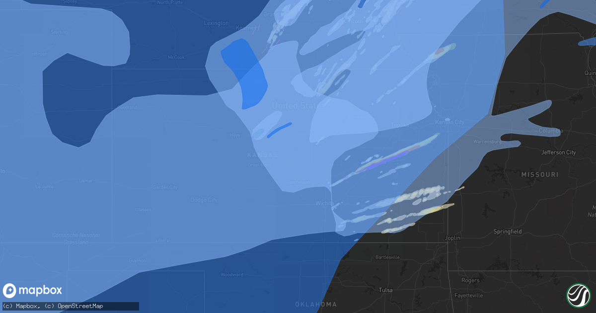
Hail Map in Kansas on December 15, 2021
Get this storm
December 15 map
$229
one time, instant access
Download today. No call, no setup
Keep the $229
Bought the map and want the full workflow? Apply the entire $229 to a subscription within 7 days. None of it is wasted.
Every map, not just this one
This buys you this map. Subscription and you get every map we run, in the markets you choose from a few cities to whole states to nationwide. Plus real-time alerts the moment a storm fires.
Contact data
Name, contact info, occupancy, even credit band for addresses in the footprint. You go from where it hit to who to call.
Become the source they trust
Unlimited branding weather history reports on demand. You already have the documented answer ready for the property owner, and you are the one who showed up with it.
Property data and RoofTrace estimates
Pull up any address you have got, its value and the exact code rules for that jurisdiction, straight from One Click Code. Then RoofTrace estimates the squares, pitch, and roof value, priced the way you price.
Storm reports in Kansas
Kansas
| Date | Description |
|---|---|
| 12/15/20215:55 PM CST | Delayed report. |
| 12/15/20215:54 PM CST | Tree on house near 83rd and corliss rd... De soto ks. Time estimated via radar. |
| 12/15/20215:52 PM CST | Report via social media. Time estimated via radar. |
| 12/15/20215:50 PM CST | Several outbuildings with roofs blown off. Time estimated via radar. |
| 12/15/20215:48 PM CST | Merriam police report multiple trees and power lines down. Time estimated from radar and social media. |
| 12/15/20215:47 PM CST | A local report indicates 61 MPH wind near 1 WSW CHANUTE |
| 12/15/20215:46 PM CST | Corrects previous tstm wnd dmg report from neodesha. Report from mping: 3-inch tree limbs broken; power poles broken. |
| 12/15/20215:45 PM CST | Delayed report: large tree around 1 ft in diameter snapped. |
| 12/15/20215:42 PM CST | Report of power line down by tree and on fire. Time estimated via radar. |
| 12/15/20215:40 PM CST | Lwc asos. |
| 12/15/20215:37 PM CST | Delayed report: mesonet station up091 1.9 e williamstown |
| 12/15/20215:37 PM CST | Report of power line down and wrapped around trampoline. Emergency responders en route. No injuries reported. |
| 12/15/20215:35 PM CST | Delayed public report. Small branches down in the area... Around 1-2 inches in diameter. Many heavy... Unsecured outdoor objects have been blown around. Power lines als |
| 12/15/20215:35 PM CST | Delayed report: awos station kowi ottawa. |
| 12/15/20215:35 PM CST | Roof off of trailer. |
| 12/15/20215:31 PM CST | Relayed by emergency management... Several storm spotters reporting 70 mph winds. |
| 12/15/20215:30 PM CST | Power lines down near mt. Olivet road and 179th. Law enforcement responding. Time estimated via radar. |
| 12/15/20215:30 PM CST | Em report of pea size hail and heavy rain with 70 mph winds. |
| 12/15/20215:25 PM CST | A local report indicates 64 MPH wind near 14 NW NEWTON |
| 12/15/20215:24 PM CST | Em reports 1-inch hail at 4104 delaware rd near pomona. Time estimated from radar. |
| 12/15/20215:22 PM CST | A local report indicates 1.75 inch wind near QUENEMO |
| 12/15/20215:20 PM CST | Delayed report. |
| 12/15/20215:20 PM CST | Multiple power poles down... Tree damage across city. |
| 12/15/20215:18 PM CST | Large tree completely across 122nd road one-half mile east of k4 highway. |
| 12/15/20215:17 PM CST | Multiple power poles down... Large barn blown down at topeka and union st. Time estimated from radar. |
| 12/15/20215:16 PM CST | Delayed report: mesonet station fw2032 valley falls. |
| 12/15/20215:15 PM CST | Delayed report from mping: 3-inch tree limbs broken; power poles broken. |
| 12/15/20215:15 PM CST | Damage to a power pole at 286th and neosho. |
| 12/15/20215:15 PM CST | A local report indicates 80 MPH wind near 3 NW PERRY |
| 12/15/20215:15 PM CST | Roof damage to building at 294th and kingman. |
| 12/15/20215:14 PM CST | Delayed report: mesonet station k5006 i-470 bridge over us-75. |
| 12/15/20215:04 PM CST | Delayed report from mping: 3-inch tree limbs broken; power poles broken. |
| 12/15/20215:04 PM CST | Asos station ktop topeka. |
| 12/15/20215:00 PM CST | Corrects previous tstm wnd gst report from matfield green. |
| 12/15/20215:00 PM CST | Apricot-sized hail. |
| 12/15/20215:00 PM CST | Delayed report from mping: 3-inch tree limbs broken; power poles broken. |
| 12/15/20214:56 PM CST | A local report indicates 65 MPH wind near 6 NNW NEOSHO RAPIDS |
| 12/15/20214:55 PM CST | Several power poles snapped. |
| 12/15/20214:55 PM CST | A local report indicates 66 MPH wind near 2 N EUREKA |
| 12/15/20214:54 PM CST | Delayed report from mping: 1-inch tree limbs broken; shingles blown off. |
| 12/15/20214:53 PM CST | Asos station kemp emporia. |
| 12/15/20214:53 PM CST | Golf ball sized hail reported at fanestil original plant on k-99. Time estimated from radar. |
| 12/15/20214:52 PM CST | Delayed report from mping: quarter |
| 12/15/20214:51 PM CST | Tennis-ball size hail reported at i-35/r1 east of emporia. Time estimated from radar. |
| 12/15/20214:50 PM CST | Delayed report from mping: 1-inch tree limbs broken; shingles blown off. |
| 12/15/20214:49 PM CST | Quarter sized hail. |
| 12/15/20214:48 PM CST | A local report indicates 62 MPH wind near 2 N EUREKA |
| 12/15/20214:47 PM CST | Softball-sized hail reported at mile marker 137 off i-35. Time estimated from radar. |
| 12/15/20214:45 PM CST | Delayed report of a metal pole barn blown down and completely destroyed. |
| 12/15/20214:43 PM CST | A local report indicates 70 MPH wind near 5 WNW MAYETTA |
| 12/15/20214:41 PM CST | Delayed report from mping: 1-inch tree limbs broken; shingles blown off. |
| 12/15/20214:40 PM CST | A local report indicates 74 MPH wind near 5 N EL DORADO |
| 12/15/20214:30 PM CST | Blown-over semi at mile marker 183 on us-81. Delayed report. |
| 12/15/20214:30 PM CST | Tree limbs down and light poles knocked over. Delayed report. Time estimated by radar. |
| 12/15/20214:20 PM CST | A local report indicates 70 MPH wind near 4 S CORNING |
| 12/15/20214:15 PM CST | A local report indicates 75 MPH wind near 6 SSE SAINT GEORGE |
| 12/15/20214:08 PM CST | Roofs peeling off buildings... Side of metal building got blown out. |
| 12/15/20214:04 PM CST | Delayed report from mping: 3-inch tree limbs broken; power poles broken. |
| 12/15/20214:00 PM CST | Blown-over semi at mile marker 165 on us-81. Delayed report. |
| 12/15/20213:58 PM CST | Delayed report from mping: trees uprooted or snapped; roof blown off. |
| 12/15/20213:58 PM CST | A local report indicates 66 MPH wind near 4 ENE NEWTON |
| 12/15/20213:53 PM CST | Delayed report. Resident in east manhattan shared pictures via social media of large tree branches down. Also reported roof shingles blown off. Time estimated. |
| 12/15/20213:53 PM CST | 7 inch tree limb down. 70 mph winds. |
| 12/15/20213:52 PM CST | Asos station kmhk manhattan. |
| 12/15/20213:49 PM CST | Em reports severe damage. Motel roof blown off and into other buildings... Power outages. Time estimated from radar. |
| 12/15/20213:47 PM CST | Metal signs bent... Siding off buildings... Damage to hangers at junction city airport. |
| 12/15/20213:46 PM CST | Report from mping: 3-inch tree limbs broken; power poles broken. |
| 12/15/20213:45 PM CST | Social media post showed half of 12 inch diameter tree blown down. |
| 12/15/20213:43 PM CST | Trees down. |
| 12/15/20213:40 PM CST | Report from mping: trees uprooted or snapped; roof blown off. |
| 12/15/20213:39 PM CST | Awos station kfri ft riley marshal. |
| 12/15/20213:32 PM CST | A local report indicates 64 MPH wind near ELLSWORTH |
| 12/15/20213:26 PM CST | 1-ft diameter tree snapped... Visibility 1 1/2 miles. |
| 12/15/20213:22 PM CST | A local report indicates 59 MPH wind near LYONS |
| 12/15/20213:18 PM CST | Metal grain bins damaged; time estimated. |
| 12/15/20213:14 PM CST | Dead trees knocked over... 12 inch diameter. |
| 12/15/20213:02 PM CST | Two 8 inch limbs are down. |
| 12/15/20213:00 PM CST | Mesonet station ew5822 clay center. |
| 12/15/20212:56 PM CST | Pea sized hail... 8in diameter tree down... 0 visibility from blowing dust and dirt. |
| 12/15/20212:56 PM CST | A local report indicates 75 MPH wind near MILTONVALE |
| 12/15/20212:55 PM CST | Report from mping: 3-inch tree limbs broken; power poles broken. |
| 12/15/20212:54 PM CST | A local report indicates 82 MPH wind near 3 SSW SALINA |
| 12/15/20212:47 PM CST | Corrects previous tstm wnd dmg report from 3 wsw bennington. Blown-over semi at mile marker 165 on us-81. Delayed report. Time corrected based on radar data. |
| 12/15/20212:45 PM CST | Tin roof rolled back on building... 6 inch tree limbs down... And fence down. |
| 12/15/20212:40 PM CST | Mesonet station k5cnc us-81 @ republican r. Concordia. |
| 12/15/20212:40 PM CST | Sustained at 50kts as well. |
| 12/15/20212:40 PM CST | A local report indicates 70 MPH wind near CULVER |
| 12/15/20212:40 PM CST | Corrects previous tstm wnd dmg report from minneapolis. Power lines and transformers down. Time estimated from radar. |
| 12/15/20212:40 PM CST | Power lines and transformers down. Time estimated from radar. |
| 12/15/20212:35 PM CST | A local report indicates 75 MPH wind near 2 SSE CONCORDIA |
| 12/15/20212:34 PM CST | A local report indicates 60 MPH wind near 1 S GLENDALE |
| 12/15/20212:34 PM CST | Corrects previous tstm wnd dmg report from 5 e delphos. Blown-over semi at mile marker 183 on us-81. Delayed report. Corrected time based off of radar. |
| 12/15/20212:32 PM CST | 4 inch tree limbs down. |
| 12/15/20212:31 PM CST | A local report indicates 67 MPH wind near 2 SSE CONCORDIA |
| 12/15/20212:31 PM CST | Corrects previous tstm wnd gst report from 2 sse concordia. |
| 12/15/20212:28 PM CST | Large ash tree down. Bent metal basketball pole in half. |
| 12/15/20212:19 PM CST | Power line with transformer down leaning in lincoln center at 5th and lost st. Railroad crossing arm snapped. Scattered reports of fallen smaller tree limbs. |
| 12/15/20212:00 PM CST | Delayed report of tree damage via em photo. Time estimated from radar. |
| 12/15/20211:55 PM CST | A local report indicates 70 MPH wind near ELLINWOOD |
| 12/15/20211:51 PM CST | A local report indicates 58 MPH wind near 6 N SYLVAN GROVE |
| 12/15/20211:46 PM CST | Very poor visibility noted as well. |
| 12/15/20211:40 PM CST | Reports of some tree limbs down and a couple touching houses. No wind speed estimate given. Time was estimated from radar. |
| 12/15/20211:00 PM CST | A local report indicates 80 MPH wind near 8 NNE CODELL |
| 12/15/20211:00 PM CST | A local report indicates 80 MPH wind near WOODRUFF |
| 12/15/202112:55 PM CST | A local report indicates 66 MPH wind near 8 SSE GLADE |
| 12/15/202112:32 PM CST | Report from mping: 1-inch tree limbs broken; shingles blown off. |
| 12/15/202112:05 PM CST | Report from mping: 1-inch tree limbs broken; shingles blown off. |
| 12/15/20212:10 AM CST | At 809 PM CST, a severe thunderstorm was located 4 miles southeast of Pawhuska, moving east at 55 mph. Another severe thunderstorm was located 4 miles southwest of Copan...also moving east at 55 mph. HAZARD...60 mph wind gusts and penny size hail. SOURCE...Radar indicated. IMPACT...Expect damage to roofs, siding, and trees. Locations in or near the path include... Bartlesville... Nowata... Pawhuska... Dewey... Barnsdall... Copan... Wynona... Ochelata... Delaware... Lenapah... Wann... Bartlesville Municipal Airport... Osage Hills State Park... Okesa... Tallant... Pershing... Nelagoney... |
| 12/15/202112:15 AM CST | At 614 PM CST, severe thunderstorms were located along a line extending from near Cameron to 6 miles northwest of Kearney to near Claycomo, moving northeast at 70 mph. HAZARD...70 mph wind gusts. SOURCE...Radar indicated. IMPACT...Expect considerable tree damage. Damage is likely to mobile homes, roofs, and outbuildings. Locations impacted include... Kansas City, Liberty, Gladstone, Excelsior Springs, Cameron, Chillicothe, Smithville, Kearney, Richmond, Lexington, North Kansas City, Carrollton, Sugar Creek, Riverside, Lawson, Lathrop, Hamilton, Claycomo, Kansas City Kansas and Pleasant Valley.This includes the following highways... Interstate 70 in Missouri between mile markers 0 and 1. Interstate 70 in Kansas between mile markers 421 and 423. Interstate 35 in Missouri between mile markers 5 and 55. Interstate 29 between mile markers 0 and 3. Interstate 635 near mile marker 12. Interstate 435 between mile markers 40 and 56. |
| 12/15/202112:06 AM CST | At 606 PM CST, severe thunderstorms were located along a line extending from near Iola to 6 miles northeast of Longton to Cedar Vale, moving east at 50 mph. HAZARD...60 mph wind gusts and nickel size hail. SOURCE...Radar indicated. IMPACT...Expect damage to roofs, siding, and trees. Locations impacted include... Parsons, Coffeyville, Independence, Chanute, Iola, Neodesha, Fredonia, Cherryvale, Caney, Humboldt, Oswego, Erie, Chetopa, Sedan, Altamont, St. Paul, Cedar Vale, La Harpe, Gas and Moran. |
| 12/14/202111:57 PM CST | At 556 PM CST, severe thunderstorms were located along a line extending from 4 miles northwest of Eudora to near Vinland to 4 miles southeast of Pomona, moving northeast at 55 mph. HAZARD...60 mph wind gusts and penny size hail. SOURCE...Radar indicated. IMPACT...Expect damage to roofs, siding, and trees. Locations impacted include... Eastern Lawrence, Ottawa, Baldwin City, Eudora, Wellsville and Vinland.This includes Interstate 35 between mile markers 187 and 198. |
| 12/14/202111:54 PM CST | At 553 PM CST, severe thunderstorms were located along a line extending from near Rantoul to 5 miles west of Colony, moving east at 70 mph. HAZARD...70 mph wind gusts and quarter size hail. SOURCE...Emergency management. IMPACT...Hail damage to vehicles is expected. Expect considerable tree damage. Wind damage is also likely to mobile homes, roofs, and outbuildings. Locations impacted include... Garnett, Burlington, Waverly, Richmond, Colony, Williamsburg, New Strawn, Greeley, Princeton, Lane, Westphalia, Kincaid, Lone Elm, Harris and Le Roy.This includes Interstate 35 between mile markers 161 and 170. |
| 12/14/202111:42 PM CST | At 540 PM CST, a severe thunderstorm was located 5 miles northwest of Princeton, moving east at 45 mph. HAZARD...70 mph wind gusts. SOURCE...Emergency management. Widespread wind damage has been reported with these storms. IMPACT...Expect considerable tree damage. Damage is likely to mobile homes, roofs, and outbuildings. Locations impacted include... Ottawa, Quenemo, Melvern and Rantoul. This includes Interstate 35 between mile markers 170 and 186. |
| 12/14/202111:24 PM CST | At 521 PM CST, severe thunderstorms were located along a line extending from 3 miles west of Tonganoxie to 3 miles north of Pleasant Grove to near Pomona, moving east at 55 mph. THESE ARE DESTRUCTIVE STORMS! HAZARD...80 mph wind gusts and ping pong ball size hail. SOURCE...Emergency management. Emergency Management reported 80 mph winds at Lake Perry 515 PM. IMPACT...Flying debris will be dangerous to those caught without shelter. Mobile homes will be heavily damaged. Expect considerable damage to roofs, windows, and vehicles. Extensive tree damage and power outages are likely. Locations impacted include... Lawrence, Ottawa, Baldwin City, Tecumseh, Eudora, Richland, Wellsville, Overbrook, Lyndon, Centropolis, Perry, Pomona, Lecompton, Clinton, Quenemo, Lone Star, Pleasant Grove, Vinland, Williamstown and Pomona Lake.This includes the following highways... Interstate 35 between mile markers 187 and 198. Kansas Turnpike between mile markers 184 and 205. |
| 12/14/202111:22 PM CST | At 521 PM CST, severe thunderstorms were located along a line extending from near Madison to 10 miles west of Severy, moving east at 55 mph. HAZARD...70 mph wind gusts. SOURCE...Radar indicated. IMPACT...Expect considerable tree damage. Damage is likely to mobile homes, roofs, and outbuildings. Locations impacted include... Eureka, Yates Center, Madison, Howard, Moline, Longton, Toronto, Hamilton, Severy, Fall River, Neosho Falls, Elk Falls, Climax, Virgil, New Albany, Coyville, Eureka City Lake, Buxton, Eureka Airport and Rose. |
| 12/14/202111:15 PM CST | At 513 PM CST, severe thunderstorms were located along a line extending from 4 miles northwest of Lebo to 4 miles east of Madison, moving east at 60 mph. THESE ARE DESTRUCTIVE STORMS! HAZARD...80 mph wind gusts and quarter size hail. SOURCE...Emergency management. Multiple damage reports have been reported with these storms. IMPACT...Flying debris will be dangerous to those caught without shelter. Mobile homes will be heavily damaged. Expect considerable damage to roofs, windows, and vehicles. Extensive tree damage and power outages are likely. Locations impacted include... Garnett, Burlington, Lebo, Waverly, Richmond, Colony, Williamsburg, New Strawn, Hartford, Gridley, Greeley, Princeton, Lane, Westphalia, Kincaid, Lone Elm, Beto Junction, Harris, John Redmond Reservoir and Le Roy.This includes Interstate 35 between mile markers 144 and 171. |
| 12/14/202111:12 PM CST | At 511 PM CST, severe thunderstorms were located along a line extending from near Braddyville to 6 miles southeast of Maitland to near Denton, moving northeast at 75 mph. THESE ARE DESTRUCTIVE STORMS FOR NORTHERN MISSOURI WITH REPORTS OF 80 TO 90 MPH WINDS.. HAZARD...80 mph wind gusts and penny size hail. SOURCE...Trained weather spotters. IMPACT...Flying debris will be dangerous to those caught without shelter. Mobile homes will be heavily damaged. Expect considerable damage to roofs, windows, and vehicles. Extensive tree damage and power outages are likely. Locations impacted include... St. Joseph, Maryville, Cameron, Savannah, Bethany, Gallatin, Albany, Wathena, Elwood, Stanberry, Maysville, Troy, Country Club Villa, Country Club, King City, Grant City, Stewartsville, Agency, Burlington Junction and Hopkins.This includes the following highways... Interstate 35 in Missouri between mile markers 56 and 113. Interstate 29 between mile markers 40 and 73. Interstate 229 between mile markers 0 and 14. |
| 12/14/202111:09 PM CST | At 508 PM CST, a severe thunderstorm was located near Melvern Lake, moving east at 70 mph. HAZARD...Two inch hail and 70 mph wind gusts. SOURCE...Trained weather spotters. Spotters reported two inch hail east of Emporia at 500 PM. IMPACT...People and animals outdoors will be injured. Expect hail damage to roofs, siding, windows, and vehicles. Expect considerable tree damage. Wind damage is also likely to mobile homes, roofs, and outbuildings. Locations impacted include... Ottawa, Wellsville, Pomona, Quenemo, Melvern, Rantoul, Olivet and Melvern Lake.This includes Interstate 35 between mile markers 171 and 198. |
| 12/14/202110:57 PM CST | At 457 PM CST, severe thunderstorms were located along a line extending from 5 miles south of Douglass to near South Haven, moving east at 30 mph. HAZARD...70 mph wind gusts. SOURCE...Radar indicated. IMPACT...Expect considerable tree damage. Damage is likely to mobile homes, roofs, and outbuildings. Locations impacted include... Arkansas City, Winfield, Oxford, Udall, Cedar Vale, Burden, South Haven, Dexter, Grenola, Atlanta, Geuda Springs, Rock, Cambridge, Hunnewell, Maple City, Winfield City Lake and Strother Field Airport.This includes Interstate 35 between Mile Markers 1 and 20. |
| 12/14/202110:53 PM CST | At 451 PM CST, severe thunderstorms were located along a line extending from Topeka to 3 miles southeast of Auburn to 4 miles northeast of Reading, moving east at 60 mph. THESE ARE DESTRUCTIVE STORMS! HAZARD...80 mph wind gusts. SOURCE...Trained weather spotters. These storms have produced widespread wind damage and winds around 80 mph. IMPACT...Flying debris will be dangerous to those caught without shelter. Mobile homes will be heavily damaged. Expect considerable damage to roofs, windows, and vehicles. Extensive tree damage and power outages are likely. Locations impacted include... Topeka, Lawrence, Ottawa, Baldwin City, Osage City, Carbondale, Tecumseh, Eudora, Richland, Wellsville, Dover, Auburn, Overbrook, Lyndon, Centropolis, Burlingame, Perry, Pomona, Scranton and Lecompton.This includes the following highways... Interstate 35 between mile markers 187 and 198. Interstate 70 between mile markers 349 and 355. Kansas Turnpike between mile markers 143 and 205. |
| 12/14/202110:43 PM CST | At 442 PM CST, severe thunderstorms were located along a line extending from near Hiawatha to near Willis to near Holton, moving northeast at 85 mph. THESE ARE DESTRUCTIVE STORMS FOR parts of northeastern Kansas and north western Missouri. HAZARD...80 mph wind gusts. SOURCE...Trained weather spotters. IMPACT...Flying debris will be dangerous to those caught without shelter. Mobile homes will be heavily damaged. Expect considerable damage to roofs, windows, and vehicles. Extensive tree damage and power outages are likely. Locations impacted include... St. Joseph, Atchison, Savannah, Wathena, Elwood, Highland, Troy, Country Club Villa, Country Club, Agency, Effingham, Dearborn, Amazonia, Rushville, Lancaster, Muscotah, Denton, Lewis And Clark Village, Doniphan and Easton.This includes the following highways... Interstate 29 between mile markers 28 and 60. Interstate 229 between mile markers 0 and 14. |
| 12/14/202110:35 PM CST | At 434 PM CST, severe thunderstorms were located along a line extending from near Americus to 16 miles northwest of Hamilton, moving east at 60 mph. THESE ARE DESTRUCTIVE STORMS! HAZARD...80 mph wind gusts. SOURCE...Trained weather spotters. Spotters have reported widespread wind damage and winds in excess of 80 mph with these storms. IMPACT...Flying debris will be dangerous to those caught without shelter. Mobile homes will be heavily damaged. Expect considerable damage to roofs, windows, and vehicles. Extensive tree damage and power outages are likely. Locations impacted include... Emporia, Burlington, Lebo, Americus, Olpe, New Strawn, Melvern, Hartford, Gridley, Neosho Rapids, Reading, Olivet, Beto Junction, John Redmond Reservoir and Melvern Lake.This includes the following highways... Interstate 35 between mile markers 128 and 162. Kansas Turnpike between mile markers 117 and 138. |
| 12/14/202110:20 PM CST | At 418 PM CST, severe thunderstorms were located along a line extending from 4 miles northwest of McFarland to 5 miles east of Alta Vista to 7 miles west of Dunlap, moving east at 50 mph. THESE ARE DESTRUCTIVE STORMS! HAZARD...80 mph wind gusts. SOURCE...Trained weather spotters. Spotters have reported wind damage and winds in excess of 80 mph with these storms. IMPACT...Flying debris will be dangerous to those caught without shelter. Mobile homes will be heavily damaged. Expect considerable damage to roofs, windows, and vehicles. Extensive tree damage and power outages are likely. Locations impacted include... Topeka, Osage City, Council Grove, Alma, Eskridge, Dover, Auburn, Burlingame, Harveyville, Allen, Admire, Bushong, Dunlap, Pauline and Keene.This includes the following highways... Interstate 70 between mile markers 346 and 355. Kansas Turnpike between mile markers 137 and 182. |
| 12/14/202110:11 PM CST | At 410 PM CST, severe thunderstorms were located along a line extending from 8 miles southeast of Burdick to near Eastborough, moving east at 55 mph. HAZARD...70 mph wind gusts. SOURCE...Trained weather spotters. IMPACT...Expect considerable tree damage. Damage is likely to mobile homes, roofs, and outbuildings. Locations impacted include... Wichita, Derby, El Dorado, Andover, Haysville, Augusta, Park City, Valley Center, Bel Aire, Mulvane, Rose Hill, Douglass, Towanda, Cottonwood Falls, Benton, Whitewater, Leon, Madison, Strong City and Downtown Wichita.This includes the following highways... Interstate 135 between Mile Markers 0 and 20. Interstate 35 between Mile Markers 34 and 115. |
| 12/14/202110:03 PM CST | At 402 PM CST, severe thunderstorms were located along a line extending from near Plattsmouth to near Nebraska City to 6 miles east of Summerfield, moving northeast at 90 mph. THESE ARE DESTRUCTIVE STORMS FOR FAR NORTHWESTERN MISSOURI. HAZARD...80 mph wind gusts and nickel size hail. SOURCE...Trained weather spotters. IMPACT...Flying debris will be dangerous to those caught without shelter. Mobile homes will be heavily damaged. Expect considerable damage to roofs, windows, and vehicles. Extensive tree damage and power outages are likely. Locations impacted include... Maryville, Savannah, Tarkio, Mound City, Highland, Rock Port, Oregon, Fairfax, Burlington Junction, Hopkins, Ravenwood, Maitland, Skidmore, Forest City, Craig, Fillmore, White Cloud, Barnard, Conception Junction and Sheridan.This includes Interstate 29 between mile markers 61 and 123. |
| 12/14/20219:39 PM CST | At 339 PM CST, severe thunderstorms were located along a line extending from near Junction City to 5 miles north of Woodbine to 3 miles southwest of Herington, moving east at 45 mph. THESE ARE DESTRUCTIVE STORMS! HAZARD...80 mph wind gusts. SOURCE...Radar indicated. IMPACT...Flying debris will be dangerous to those caught without shelter. Mobile homes will be heavily damaged. Expect considerable damage to roofs, windows, and vehicles. Extensive tree damage and power outages are likely. Locations impacted include... Junction City, Council Grove, Grandview Plaza, White City, Alta Vista, Dwight, Wilsey, Parkerville, Latimer, Council Grove Lake, Volland and Burdick.This includes Interstate 70 between mile markers 293 and 299, andbetween mile markers 325 and 326. |
| 12/14/20219:35 PM CST | At 333 PM CST, severe thunderstorms were located along a line extending from 5 miles northeast of Prague to 5 miles north of Oketo, moving east at 65 mph. THESE ARE DESTRUCTIVE STORMS. HAZARD...80 mph wind gusts and penny size hail. SOURCE...Radar indicated. IMPACT...Flying debris will be dangerous to those caught without shelter. Mobile homes will be heavily damaged. Expect considerable damage to roofs, windows, and vehicles. Extensive tree damage and power outages are likely. Locations impacted include... Pawnee City, Kennard, Table Rock, Blair, Humboldt, Fort Calhoun, Missouri Valley, Modale, Stella, Shubert, Logan and Persia.This includes the following highways... Interstate 29 between mile markers 1 and 84. Interstate 80 in Iowa between mile markers 1 and 27. Interstate 80 in Nebraska between mile markers 432 and 454. |
| 12/14/20219:10 PM CST | At 310 PM CST, severe thunderstorms were located along a line extending from 6 miles south of Gypsum to Moundridge, moving east at 45 mph. HAZARD...70 mph wind gusts. SOURCE...Radar indicated. IMPACT...Expect considerable tree damage. Damage is likely to mobile homes, roofs, and outbuildings. Locations impacted include... Newton, Hesston, Hillsboro, Halstead, Marion, North Newton, Moundridge, Sedgwick, Peabody, Canton, Florence, Goessel, Walton, Burns, Lincolnville, Ramona, Lehigh, Durham, Tampa and Lost Springs.This includes Interstate 135 between Mile Markers 23 and 49. |
| 12/14/20219:00 PM CST | At 259 PM CST, severe thunderstorms were located along a line extending from 3 miles northeast of Niles to near Gypsum to 7 miles east of Lindsborg, moving northeast at 45 mph. THESE ARE DESTRUCTIVE STORMS! HAZARD...80 mph wind gusts. SOURCE...Trained weather spotters. WInds around Salina have gusted over 80 mph. IMPACT...Flying debris will be dangerous to those caught without shelter. Mobile homes will be heavily damaged. Expect considerable damage to roofs, windows, and vehicles. Extensive tree damage and power outages are likely. Locations impacted include... Abilene, Herington, Chapman, Solomon, Enterprise, Hope, Woodbine, Carlton and Moonlight.This includes Interstate 70 between mile markers 267 and 292. |
| 12/14/20218:54 PM CST | At 253 PM CST, severe thunderstorms were located along a line extending from 5 miles southeast of Stromsburg to Mahaska, moving northeast at 65 mph. THESE ARE DESTRUCTIVE STORMS. HAZARD...80 mph wind gusts and penny size hail. SOURCE...Radar indicated. IMPACT...Flying debris will be dangerous to those caught without shelter. Mobile homes will be heavily damaged. Expect considerable damage to roofs, windows, and vehicles. Extensive tree damage and power outages are likely. Locations impacted include... Beatrice, Pickrell, Cedar Bluffs, Fremont, Inglewood, Arlington and Sterling.This includes Interstate 80 in Nebraska between mile markers 397 and432. |
| 12/14/20218:42 PM CST | At 240 PM CST, severe thunderstorms were located along a line extending from 5 miles north of Hubbell to near Agenda to 4 miles east of Culver, moving northeast at 60 mph. THESE ARE DESTRUCTIVE STORMS! HAZARD...80 mph wind gusts. SOURCE...Trained weather spotters. IMPACT...Flying debris will be dangerous to those caught without shelter. Mobile homes will be heavily damaged. Expect considerable damage to roofs, windows, and vehicles. Extensive tree damage and power outages are likely. Locations impacted include... Clay Center, Minneapolis, Washington, Wakefield, Clyde, Hanover, Bennington, Clifton, Miltonvale, Linn, Greenleaf, Morganville, Barnes, Cuba, Morrowville, Green, Culver, Wells, Palmer and Haddam. |
| 12/14/20218:26 PM CST | At 225 PM CST, severe thunderstorms were located along a line extending from Hordville to 4 miles northwest of Deshler, moving northeast at 85 mph. HAZARD...70 mph wind gusts. SOURCE...Radar indicated. IMPACT...Expect considerable tree damage. Damage is likely to mobile homes, roofs, and outbuildings. Locations impacted include... Friend, Dorchester, Crete, Milford, Pleasant Dale and northwestern Lincoln.This includes Interstate 80 in Nebraska between mile markers 366 and395. |
| 12/14/20218:12 PM CST | At 211 PM CST, severe thunderstorms were located along a line extending from 6 miles south of Barnard to near Alden, moving northeast at 55 mph. HAZARD...70 mph wind gusts. SOURCE...Radar indicated. IMPACT...Expect considerable tree damage. Damage is likely to mobile homes, roofs, and outbuildings. Locations impacted include... Salina, Mcpherson, Lindsborg, Moundridge, Inman, Galva, Canton, Marquette, Assaria, Gypsum, Brookville, Smolan, Windom, New Cambria, Falun, Glendale, Salina Airport, Mcpherson Airport, Roxbury and Bridgeport.This includes the following highways... Interstate 135 between Mile Markers 43 and 95. Interstate 70 between Mile Markers 236 and 266. |
| 12/14/20218:08 PM CST | At 207 PM CST, severe thunderstorms were located along a line extending from Ashton to near Giltner to near Bostwick, moving northeast at 85 mph. HAZARD...70 mph wind gusts and nickel size hail. SOURCE...Trained weather spotters. IMPACT...Expect considerable tree damage. Damage is likely to mobile homes, roofs, and outbuildings. Severe thunderstorms will be near... Grand Island, Giltner, Phillips and Farwell around 210 PM CST. Aurora, Nelson, Chapman, Elba and Cotesfield around 215 PM CST. Marquette, Ruskin, Oak and Nora around 220 PM CST. Central City, Greeley, Davenport, Wolbach and Hordville around 225 PM CST.Other locations in the path of these severe thunderstorms includeClarks, Polk, Carleton, Spalding, Shickley, Bruning, Strang, Geneva,Osceola, Silver Creek, Ohiowa and Milligan.This includes Interstate 80 between mile markers 313 and 365. |
| 12/14/20217:57 PM CST | At 154 PM CST, severe thunderstorms were located along a line extending from 3 miles southwest of Lawrence to near Mankato to 9 miles south of Lincoln, moving east at 55 mph. THESE ARE DESTRUCTIVE STORMS! HAZARD...80 mph wind gusts. SOURCE...Radar indicated. IMPACT...Flying debris will be dangerous to those caught without shelter. Mobile homes will be heavily damaged. Expect considerable damage to roofs, windows, and vehicles. Extensive tree damage and power outages are likely. Locations impacted include... Concordia, Minneapolis, Belleville, Clyde, Bennington, Miltonvale, Glasco, Scandia, Delphos, Tescott, Jamestown, Courtland, Cuba, Norway, Culver, Wells, Republic, Munden, Narka and Agenda. |
| 12/14/20217:33 PM CST | At 131 PM CST, severe thunderstorms were located along a line extending from near Luray to near Great Bend, moving northeast at 50 mph. THIS LINE OF STORMS IS PRODUCING DESTRUCTIVE WINDS! HAZARD...80 TO 90 mph wind gusts. SOURCE...Radar indicated. IMPACT...You are in a life-threatening situation. Flying debris may be deadly to those caught without shelter. Mobile homes will be heavily damaged or destroyed. Homes and businesses will have substantial roof and window damage. Expect extensive tree damage and power outages. Locations impacted include... Great Bend, Russell, Lyons, Ellsworth, Hoisington, Sterling, Ellinwood, Wilson, Claflin, Kanopolis, Lincoln, Little River, Chase, Holyrood, Lucas, Gorham, Bushton, Sylvan Grove, Geneseo and Pawnee Rock.This includes Interstate 70 between Mile Markers 176 and 235. |
| 12/14/20217:24 PM CST | At 123 PM CST, severe thunderstorms were located along a line extending from 8 miles southwest of Riverton to near Luray, moving east at 55 mph. HAZARD...70 mph wind gusts. SOURCE...Trained weather spotters. IMPACT...Expect considerable tree damage. Damage is likely to mobile homes, roofs, and outbuildings. Locations impacted include... Hunter, Victor and Webber. |
| 12/14/20217:13 PM CST | Storm caused roof damage to a home on locust rd east of fort scott. Home lost shingles and had gutter damage. |
| 12/14/20217:02 PM CST | Report from mping: 1-inch tree limbs broken; shingles blown off. |
| 12/14/20216:51 PM CST | Three inch tree limbs broken; power poles broken. Via mping. |
| 12/14/20216:40 PM CST | A power pole and four inch tree limbs down in mapleton. |
| 12/14/20216:37 PM CST | Lots of trees downed between iola and humboldt on 1100. Winds estimated between 60-70 mph. |
| 12/14/20216:30 PM CST | Delayed report...70mph winds... A large tree knocked down... And two power poles down due to thunderstorm wind gusts. Moran was still without power in spots this mornin |
| 12/14/20216:30 PM CST | North of town on us160. |
| 12/14/20216:28 PM CST | A local report indicates 60 MPH wind near MATFIELD GREEN |
| 12/14/20216:27 PM CST | Zero visibility. |
| 12/14/20216:24 PM CST | A local report indicates 70 MPH wind near 4 W ALTOONA |
| 12/14/20216:22 PM CST | A local report indicates 68 MPH wind near IOLA AIRPORT (KK88) |
| 12/14/20216:01 PM CST | Tree on house near w 67th st and nieman rd. Time estimated via radar. |
| 12/14/20216:01 PM CST | A local report indicates 70 MPH wind near COLONY |
| 12/14/20216:01 PM CST | Delayed report: large tree fell on a house causing roof damage. |
All States Impacted by Hail Map on December 15, 2021
Cities Impacted by Hail Map on December 15, 2021
- Nowata, OK
- Delaware, OK
- Americus, KS
- Emporia, KS
- Uniontown, KS
- Redfield, KS
- Whitewater, KS
- Newton, KS
- Mapleton, KS
- Fort Scott, KS
- Moran, KS
- Fulton, KS
- Bronson, KS
- Odebolt, IA
- Holmen, WI
- Axtell, KS
- Pawnee City, NE
- Burchard, NE
- Plattsmouth, NE
- Pacific Junction, IA
- Glenwood, IA
- Murray, NE
- Savonburg, KS
- Fall River, KS
- Fredonia, KS
- Toronto, KS
- Saint Edward, NE
- Fullerton, NE
- Belgrade, NE
- Oakland, IA
- Carson, IA
- Onaga, KS
- Ayr, NE
- Hastings, NE
- Avoca, NE
- Weeping Water, NE
- Elmwood, NE
- Neodesha, KS
- Ottawa, KS
- Onalaska, WI
- Burns, KS
- Osceola, NE
- Giltner, NE
- Hordville, NE
- Marquette, NE
- Stromsburg, NE
- Phillips, NE
- Polk, NE
- Aurora, NE
- Doniphan, NE
- Silver Creek, NE
- Clarks, NE
- Ogden, IA
- Milford, NE
- Dorchester, NE
- Winfield, KS
- Stark, KS
- Prague, NE
- Bruno, NE
- Springfield, NE
- Eagle, NE
- Gretna, NE
- Papillion, NE
- Murdock, NE
- Omaha, NE
- Louisville, NE
- Alvo, NE
- Ashland, NE
- Elk City, KS
- Olpe, KS
- Strong City, KS
- Greenwood, NE
- Pleasant Dale, NE
- Lincoln, NE
- Friend, NE
- Leigh, NE
- Monroe, NE
- Duncan, NE
- Hampton, NE
- Trumbull, NE
- Clarkson, NE
- Shelby, NE
- Columbus, NE
- Arcadia, KS
- Walnut, KS
- Bronaugh, MO
- Erie, KS
- Saint Paul, KS
- Farlington, KS
- Girard, KS
- Liberal, MO
- Hepler, KS
- Morrowville, KS
- Clifton, KS
- Mound City, MO
- Skidmore, MO
- Barnard, MO
- Ravenwood, MO
- Maryville, MO
- Graham, MO
- Maitland, MO
- Clyde, MO
- Conception Junction, MO
- Pierson, IA
- Bronson, IA
- Hornick, IA
- Climbing Hill, IA
- Sloan, IA
- Correctionville, IA
- Kingsley, IA
- Moville, IA
- Anthon, IA
- Salix, IA
- Jefferson, IA
- Augusta, KS
- Bartlesville, OK
- Nehawka, NE
- Carroll, IA
- Scranton, IA
- Cambridge, KS
- Latham, KS
- Burden, KS
- Atlanta, KS
- Trempealeau, WI
- Galesville, WI
- Dakota, MN
- Roseland, NE
- Bladen, NE
- Linn, KS
- Agenda, KS
- Concordia, KS
- Washington, KS
- Clyde, KS
- Hollenberg, KS
- Haddam, KS
- Missouri Valley, IA
- Humboldt, KS
- La Harpe, KS
- Iola, KS
- Yates Center, KS
- Coon Rapids, IA
- Exira, IA
- Hamlin, IA
- Syracuse, NE
- Vassar, KS
- Neosho Rapids, KS
- Lebo, KS
- New Century, KS
- Pomona, KS
- Quenemo, KS
- Wellsville, KS
- Gardner, KS
- Eudora, KS
- Cedar Point, KS
- Lyndon, KS
- Osage City, KS
- Edgerton, KS
- Reading, KS
- Olathe, KS
- Melvern, KS
- Cottonwood Falls, KS
- Baldwin City, KS
- Bennet, NE
- Nebraska City, NE
- Macedonia, IA
- Marne, IA
- Union, NE
- Hancock, IA
- Hastings, IA
- Treynor, IA
- Brayton, IA
- Silver City, IA
- Unadilla, NE
- Council Bluffs, IA
- Mineola, IA
- Offutt Afb, NE
- Dunbar, NE
- Walnut, IA
- Elk Horn, IA
- Bellevue, NE
- Guthrie Center, IA
- Malvern, IA
- Palmyra, NE
- Otoe, NE
- Henderson, IA
- Audubon, IA
- Atlantic, IA
- Bayard, IA
- Edgar, NE
- Williams, IA
- Blairsburg, IA
- David City, NE
- Richards, MO
- Ithaca, NE
- Lincolnville, KS
- Madison, KS
- Palmer, NE
- Essex, IA
- Buffalo, KS
- Fort Calhoun, NE
- Iowa Falls, IA
- Popejoy, IA
- Dows, IA
- Alden, IA
- Hampton, IA
- Filley, NE
- Beatrice, NE
- Blue Springs, NE
- Steele City, NE
- Fairbury, NE
- Belleville, KS
- Odell, NE
- Cuba, KS
- Diller, NE
- Hanover, KS
- Wymore, NE
- Endicott, NE
- Mahaska, KS
- Hooper, NE
- Cedar Bluffs, NE
- Ames, NE
- Fremont, NE
- Onawa, IA
- Whiting, IA
- Decatur, NE
- Macy, NE
- Thayer, KS
- Arma, KS
- Galesburg, KS
- Piedmont, KS
- Severy, KS
- Washta, IA
- Quimby, IA
- Ettrick, WI
- Winona, MN
- La Crescent, MN
- Brainard, NE
- Boone, IA
- Stratford, IA
- Pilot Mound, IA
- Schuyler, NE
- Howard, KS
- Grenola, KS
- Longton, KS
- Moline, KS
- Rock, KS
- Juniata, NE
- Holton, KS
- Waverly, KS
- Dexter, KS
- Burlington, KS
- Hartford, KS
- Talmage, NE
- Powhattan, KS
- Hiawatha, KS
- Salina, KS
- Assaria, KS
- Gypsum, KS
- Solomon, KS
- Chanute, KS
- Bellwood, NE
- Rising City, NE
- Cherryvale, KS
- Dennis, KS
- Parsons, KS
- Havana, KS
- Sedan, KS
- Independence, KS
- Elk Falls, KS
- West Point, NE
- Garnett, KS
- Williamsburg, KS
- White Cloud, KS
- Craig, MO
- Dodge, NE
- Greene, IA
- Charles City, IA
- Marble Rock, IA
- Bristow, IA
- Palmer, KS
- Waverly, NE
- Ceresco, NE
- Bancroft, NE
- Parnell, MO
- Sheridan, MO
- Stanberry, MO
- Walker, MO
- Nevada, MO
- Fort Leavenworth, KS
- Gridley, KS
- Vinita, OK
- Clay Center, KS
- Morganville, KS
- Miltonvale, KS
- Wetmore, KS
- Netawaka, KS
- Grand Island, NE
- Howells, NE
- Saint Paul, NE
- Elsmore, KS
- Scribner, NE
- Havensville, KS
- Admire, KS
- Summerfield, KS
- Nemaha, NE
- Brownville, NE
- Baileyville, KS
- Humboldt, NE
- Table Rock, NE
- Auburn, NE
- Raymond, NE
- Leon, KS
- Aredale, IA
- Rose Hill, KS
- Tobias, NE
- Rogers, NE
- Burr, NE
- Douglas, NE
- Martell, NE
- Crete, NE
- Rodney, IA
- Smithland, IA
- Barnsdall, OK
- Ochelata, OK
- Chapman, NE
- Malcolm, NE
- Davey, NE
- Firth, NE
- Panama, NE
- Hickman, NE
- Adams, NE
- Pickrell, NE
- Panora, IA
- Bagley, IA
- Yale, IA
- Jamaica, IA
- Central City, NE
- Dayton, IA
- Wisner, NE
- Beemer, NE
- Sergeant Bluff, IA
- Goff, KS
- Bennington, NE
- Waterloo, NE
- Elkhorn, NE
- Benedict, NE
- Barnes, KS
- Greenleaf, KS
- Mead, NE
- Yutan, NE
- Stanhope, IA
- Boxholm, IA
- Paton, IA
- York, NE
- Hubbell, NE
- Munden, KS
- Narka, KS
- Melrose, WI
- Derby, KS
- Andover, KS
- Wichita, KS
- Virginia, NE
- Crab Orchard, NE
- Linwood, NE
- Sterling, NE
- Roca, NE
- Horton, KS
- Robinson, KS
- Bolckow, MO
- Forest City, MO
- Oregon, MO
- Grand Junction, IA
- Dana, IA
- Rippey, IA
- North Bend, NE
- Morse Bluff, NE
- Manley, NE
- Charter Oak, IA
- Grimes, IA
- Verdigre, NE
- Milton, KS
- Surprise, NE
- Bondurant, IA
- Counselor, NM
- Pemberton, MN
- Wallingford, IA
- Randall, KS
- Pritchett, CO
- Center, CO
- Vernon Center, MN
- Offerle, KS
- Oberlin, KS
- Branson, CO
- Downs, KS
- Wilsey, KS
- Maybell, CO
- Happy, TX
- Halbur, IA
- Durango, CO
- Barnum, IA
- White River, SD
- Fort Garland, CO
- Tierra Amarilla, NM
- Pierre, SD
- Fulton, SD
- San Jon, NM
- Weldon, IA
- White Owl, SD
- Thoreau, NM
- Danville, KS
- Wentworth, SD
- Bristow, NE
- Rainsville, NM
- Minneota, MN
- Amalia, NM
- Malmo, NE
- Cunningham, KS
- Soldier, IA
- Cimarron, KS
- Hillsboro, KS
- Revere, MN
- Lineville, IA
- Rosalia, KS
- Casa Blanca, NM
- Tabor, IA
- Idaho Springs, CO
- Magnet, NE
- Harveyville, KS
- Box Elder, SD
- Merna, NE
- Calumet, IA
- Presho, SD
- Scotia, NE
- Albin, WY
- Lost Springs, WY
- Meservey, IA
- Haysville, KS
- Storden, MN
- Breckenridge, MO
- Childress, TX
- Independence, MO
- Canjilon, NM
- Springlake, TX
- Swink, CO
- Drummond, OK
- Placitas, NM
- Lyman, NE
- Jamestown, KS
- Solano, NM
- Oakdale, NE
- Pisgah, IA
- Pratt, KS
- Fairview, KS
- Platte, SD
- Missouri City, MO
- Webster, MN
- Coaldale, CO
- Burlington, CO
- Rockwell, IA
- Truesdale, IA
- Leavenworth, KS
- Cherokee, IA
- Plankinton, SD
- Bryant, SD
- Naponee, NE
- Laurens, IA
- Bruce, SD
- Turon, KS
- Warner, SD
- Martensdale, IA
- Bogue, KS
- Alva, OK
- Arnolds Park, IA
- Cologne, MN
- Pukwana, SD
- Hobbs, NM
- Corning, IA
- Pueblo, CO
- Grant City, MO
- Lake View, IA
- Hardy, IA
- Morland, KS
- Dexter, IA
- Cedaredge, CO
- Oklahoma City, OK
- Glencoe, MN
- Yampa, CO
- Effingham, KS
- Dolliver, IA
- Longford, KS
- Vaughn, NM
- Logan, IA
- Vega, TX
- Wiggins, CO
- Lodgepole, SD
- Orchard, CO
- Blooming Prairie, MN
- Halstead, KS
- Northville, SD
- Chester, OK
- Olney Springs, CO
- Mapleton, IA
- McCracken, KS
- Vinson, OK
- Matador, TX
- Flagler, CO
- Allenspark, CO
- Taloga, OK
- Kenyon, MN
- Hospers, IA
- Watertown, SD
- Colton, SD
- Bloomfield, NM
- Fort Sumner, NM
- Jamestown, NM
- Clinton, MN
- Hanston, KS
- Wilmore, KS
- Okarche, OK
- Coin, IA
- Odessa, MN
- Madison, MN
- Alcester, SD
- Buena Vista, NM
- Lonsdale, MN
- Steen, MN
- Guernsey, WY
- Kensington, KS
- Bethune, CO
- Martin, SD
- Harrisburg, SD
- Allerton, IA
- Emmet, NE
- Colon, NE
- Mitchell, NE
- Dulce, NM
- Enders, NE
- Wayne, NE
- Central City, CO
- North Loup, NE
- Roxbury, KS
- Lorimor, IA
- Milbank, SD
- Blockton, IA
- Rockham, SD
- Nekoma, KS
- Weston, NE
- Lockney, TX
- Rexford, KS
- Herndon, KS
- Elysian, MN
- Kersey, CO
- Guymon, OK
- Molina, CO
- Claflin, KS
- Satanta, KS
- Gilbert, IA
- Hills, MN
- Granada, MN
- Gibbon, NE
- Lewisville, MN
- Owanka, SD
- Artesian, SD
- Beaver, OK
- Clay Center, NE
- Clearwater, KS
- Carpenter, WY
- Idledale, CO
- Goodwin, SD
- Fort Pierre, SD
- Manly, IA
- Edgerton, MO
- Dearborn, MO
- Simpson, KS
- Jewell, IA
- Dunnell, MN
- Hitchcock, SD
- Murray, IA
- Quanah, TX
- Darfur, MN
- Quitaque, TX
- Rociada, NM
- Gateway, CO
- Miller, SD
- Poncha Springs, CO
- Marion, SD
- Warsaw, MN
- Blackwell, OK
- Atlanta, NE
- Mora, NM
- Nunn, CO
- Vivian, SD
- Fairburn, SD
- Ringwood, OK
- Byers, KS
- Blencoe, IA
- Booneville, IA
- Enning, SD
- Wallace, NE
- Spencer, IA
- Hugoton, KS
- Palco, KS
- Mercer, MO
- Oneida, KS
- Omega, OK
- Superior, NE
- Waubay, SD
- Vona, CO
- Mount Hope, KS
- Newman Grove, NE
- Memphis, TX
- Dresden, KS
- Lu Verne, IA
- Mason City, NE
- Latimer, IA
- Valmora, NM
- Denison, KS
- De Witt, NE
- Ness City, KS
- Steinauer, NE
- Morgan, MN
- Silver Lake, KS
- Titonka, IA
- Wolfforth, TX
- Nicollet, MN
- Delphos, KS
- Parmelee, SD
- South Haven, KS
- Crookston, NE
- Farley, MO
- Phippsburg, CO
- Parlin, CO
- Alta, IA
- Peru, IA
- Wildorado, TX
- Hershey, NE
- Eagle Grove, IA
- Edgemont, SD
- Romeo, CO
- Boncarbo, CO
- Oldham, SD
- Chillicothe, MO
- Empire, CO
- Freeman, SD
- Scranton, KS
- Granville, IA
- Ridgway, CO
- Chester, SD
- Fonda, IA
- Vadito, NM
- Erick, OK
- Del Norte, CO
- Tatum, NM
- Saint Libory, NE
- Moorland, IA
- Golden, CO
- Rosalie, NE
- Red Feather Lakes, CO
- Winfred, SD
- Ogden, KS
- Thurston, NE
- Binger, OK
- Hinton, IA
- Fordyce, NE
- Orchard, NE
- Deerfield, KS
- Maxwell, NM
- Littleton, CO
- Datil, NM
- Scandia, KS
- Emerson, NE
- Goodland, KS
- Palisade, NE
- Cee Vee, TX
- Osmond, NE
- Wesley, IA
- Mankato, MN
- Ravenna, NE
- Garden Grove, IA
- Oskaloosa, KS
- Foss, OK
- Sheffield, IA
- Lamoni, IA
- Modale, IA
- Holland, MN
- Shubert, NE
- New Underwood, SD
- Maize, KS
- Villisca, IA
- Corydon, IA
- Highland, KS
- Stapleton, NE
- Torreon, NM
- Ellsworth, MN
- Sundown, TX
- Carlsbad, NM
- Minturn, CO
- Ohio City, CO
- Ringsted, IA
- Hardwick, MN
- Bison, OK
- Sanborn, MN
- Lenox, IA
- Parker, KS
- Lakefield, MN
- Western, NE
- Creston, IA
- Canistota, SD
- Oneill, NE
- Frankfort, KS
- Schleswig, IA
- Granite, CO
- Clarksdale, MO
- Encino, NM
- Windsor Heights, IA
- Elbert, CO
- Anton Chico, NM
- Waterbury, NE
- Shambaugh, IA
- Crescent, IA
- Kiowa, KS
- Marienthal, KS
- Westbrook, MN
- Scarville, IA
- Humphrey, NE
- Colony, OK
- Snowmass, CO
- Early, IA
- Weston, MO
- Hagerman, NM
- Canones, NM
- Center, NE
- Interior, SD
- Luther, IA
- San Ysidro, NM
- Sayre, OK
- Sentinel, OK
- Parshall, CO
- Burns, CO
- Crawford, OK
- Gilmore City, IA
- North Sioux City, SD
- Santa Fe, NM
- Canton, OK
- Wamego, KS
- Albany, MO
- Dillon, CO
- Sutherland, IA
- West Des Moines, IA
- Hamilton, KS
- Topeka, KS
- Brookville, KS
- Cedar, KS
- Welda, KS
- Willow Island, NE
- Elsie, NE
- Saint Joseph, MO
- Oelrichs, SD
- Tingley, IA
- Reva, SD
- Fairmont, NE
- Ricketts, IA
- Hartford, SD
- Cheney, KS
- Yoder, WY
- Thurman, IA
- Jackson, NE
- Laramie, WY
- Long Island, KS
- Murdock, KS
- Prairie Village, KS
- Randolph, IA
- Cordova, NM
- Lorraine, KS
- Waseca, MN
- Hollis, OK
- Brownell, KS
- Lebanon, KS
- Burr Oak, KS
- Ashland, KS
- Ireton, IA
- Rozel, KS
- Salem, NE
- Crossroads, NM
- Adrian, TX
- Ottosen, IA
- Bradley, SD
- Johnston, IA
- Imperial, NE
- Basalt, CO
- Dundas, MN
- Callaway, NE
- Ojo Caliente, NM
- Kanopolis, KS
- Oak Grove, MO
- Ellendale, MN
- Peralta, NM
- Peabody, KS
- Clayton, KS
- Beulah, CO
- Sioux Falls, SD
- Berthoud, CO
- Brady, NE
- Evans, CO
- Dow City, IA
- Clatonia, NE
- Garrett, WY
- Lester, IA
- Fairfax, MN
- Albuquerque, NM
- Drake, CO
- Newport, NE
- Pinehill, NM
- Wood Lake, NE
- Fort Morgan, CO
- Fedora, SD
- Gillett Grove, IA
- Lovington, NM
- Mclean, TX
- Duncombe, IA
- Delta, CO
- Blanchard, IA
- Jetmore, KS
- Falun, KS
- Piqua, KS
- Canute, OK
- Harrison, NE
- Lincoln, KS
- Andale, KS
- Hereford, TX
- Lucas, IA
- Clearmont, MO
- Grenville, NM
- Underwood, IA
- Hurley, SD
- Simla, CO
- Du Bois, NE
- Cochiti Pueblo, NM
- Savannah, MO
- Afton, IA
- Darlington, MO
- Portales, NM
- Braddyville, IA
- Oakwood, OK
- Medford, OK
- Bigelow, MN
- San Cristobal, NM
- Bingham Lake, MN
- Oyens, IA
- Cuervo, NM
- De Soto, IA
- La Veta, CO
- Emmons, MN
- Bard, NM
- Waco, NE
- Farragut, IA
- Winterset, IA
- Cook, NE
- Ashton, IA
- Byers, CO
- San Luis, CO
- Volin, SD
- Sheridan Lake, CO
- Deshler, NE
- Knierim, IA
- Aspinwall, IA
- Taiban, NM
- Chappell, NE
- Oxford, NE
- Fostoria, IA
- Pfeifer, KS
- Jordan, MN
- Shawnee, WY
- Bucklin, KS
- Watrous, NM
- Cody, NE
- Bradgate, IA
- Ohkay Owingeh, NM
- Midland, SD
- Kirtland, NM
- Little River, KS
- Windom, KS
- Plains, TX
- Seagraves, TX
- Ree Heights, SD
- Battle Creek, NE
- Trinchera, CO
- Las Vegas, NM
- Lubbock, TX
- Tampa, KS
- Nenzel, NE
- Neola, IA
- Nemo, SD
- Echo, MN
- Canby, MN
- Trenton, MO
- Gresham, NE
- Le Mars, IA
- Panhandle, TX
- Cresbard, SD
- Hanlontown, IA
- Lake City, CO
- Amboy, MN
- Mission, SD
- Cascade, CO
- Stuart, NE
- Harlan, IA
- Hernandez, NM
- Orrick, MO
- Fort Cobb, OK
- Liberal, KS
- Valley Falls, KS
- Logan, KS
- Reliance, SD
- Byron, NE
- Chadron, NE
- Summerfield, TX
- Bovina, TX
- Wolcott, CO
- Belle Plaine, MN
- Otho, IA
- Everly, IA
- Limon, CO
- Chandler, MN
- Seminole, TX
- Tijeras, NM
- Ensign, KS
- Gill, CO
- Torrington, WY
- Shickley, NE
- Pitkin, CO
- Lance Creek, WY
- Mooreland, OK
- Patterson, IA
- Alda, NE
- Hubbard, IA
- Sylvia, KS
- Axtell, NE
- Willow, OK
- Elk Mountain, WY
- Des Moines, IA
- Hugo, CO
- Pleasanton, NE
- Nevada, IA
- Corsica, SD
- Sawyer, KS
- Rapid City, SD
- Lancaster, KS
- Colome, SD
- Cheyenne, OK
- Rush, CO
- Grafton, IA
- Gravity, IA
- Prewitt, NM
- Summit, SD
- Larrabee, IA
- Granada, CO
- Hasty, CO
- Erwin, SD
- Shattuck, OK
- Johnstown, CO
- Cortez, CO
- Protection, KS
- Stilwell, KS
- Holdrege, NE
- Esbon, KS
- Cubero, NM
- Syracuse, KS
- Mcdonald, NM
- Henry, SD
- Shawnee, CO
- Chama, CO
- McDonald, KS
- Freedom, OK
- Rollinsville, CO
- Archer, NE
- Plattsburg, MO
- Hardy, NE
- Forgan, OK
- La Loma, NM
- Coldwater, KS
- Hardin, MO
- Monument, CO
- Hopkins, MO
- El Prado, NM
- Neligh, NE
- Potwin, KS
- Ralls, TX
- Gann Valley, SD
- Hardtner, KS
- Willard, NM
- Wounded Knee, SD
- Union City, OK
- Allen, KS
- Mcalister, NM
- Creighton, NE
- Thor, IA
- Wagner, SD
- Pilger, NE
- Monument, KS
- Lake Arthur, NM
- Colby, KS
- Durham, OK
- Corona, NM
- Benkelman, NE
- Lexington, MO
- Folsom, NM
- Wheatland, WY
- Sutherland, NE
- Rulo, NE
- Potter, NE
- Anita, IA
- Buffalo Center, IA
- Berryton, KS
- Bailey, CO
- Ludell, KS
- Brighton, CO
- Stoneham, CO
- North Newton, KS
- Norwood Young America, MN
- Plainview, TX
- Ayrshire, IA
- Andover, SD
- Mosca, CO
- Wanda, MN
- Maple City, KS
- Ransom, KS
- Edgerton, MN
- College Springs, IA
- Randall, IA
- Garden City, KS
- Kranzburg, SD
- Bellvue, CO
- Dickens, NE
- Pecos, TX
- Ransom Canyon, TX
- Isabel, KS
- Leadville, CO
- Ponderosa, NM
- Lamont, OK
- Burnside, IA
- Delia, KS
- Isleta, NM
- Coleridge, NE
- Lone Jack, MO
- Ansley, NE
- Silverton, TX
- Grain Valley, MO
- Manville, WY
- Madrid, IA
- Garita, NM
- Julian, NE
- Gayville, SD
- Wabasso, MN
- Rolfe, IA
- Catharine, KS
- Linn Grove, IA
- Carr, CO
- Coal Creek, CO
- Winter Park, CO
- Akron, CO
- Holcomb, KS
- Keenesburg, CO
- Rosendale, MO
- Morton, TX
- Mangum, OK
- Hamilton, CO
- Henrietta, MO
- Naper, NE
- Beaumont, KS
- Greenwood, MO
- Agency, MO
- Cleo Springs, OK
- Riverton, NE
- Cotopaxi, CO
- Russell, MN
- Lehigh, IA
- Princeton, KS
- Stinnett, TX
- Lake Benton, MN
- Riley, KS
- San Rafael, NM
- Dodson, TX
- Hanska, MN
- Springfield, SD
- Wanblee, SD
- Hinton, OK
- Towanda, KS
- Blomkest, MN
- Dickens, IA
- Janesville, MN
- Gothenburg, NE
- Walker, KS
- Maple, TX
- Tererro, NM
- Alden, MN
- Clayton, NM
- Minneola, KS
- Cuba, NM
- Elk Creek, NE
- Gregory, SD
- Almena, KS
- Stewart, MN
- Goldfield, IA
- Raymond, KS
- New Prague, MN
- Lenora, KS
- Langford, SD
- Broken Bow, NE
- Camp Crook, SD
- Beresford, SD
- Rosebud, SD
- Turkey, TX
- Inwood, IA
- Shelton, NE
- Orlando, OK
- Medford, MN
- Halsey, NE
- Union Center, SD
- Navajo Dam, NM
- Harvard, NE
- Ellsworth, NE
- Heron Lake, MN
- Quinn, SD
- Fort Laramie, WY
- Camden, MO
- Labolt, SD
- Lennox, SD
- Kirk, CO
- Casey, IA
- Mancos, CO
- Hill City, SD
- Moriarty, NM
- Albert Lea, MN
- Utica, MO
- Hillsdale, WY
- Morrison, OK
- Granger, IA
- Indianola, IA
- Ralph, SD
- Humboldt, SD
- Geneva, MN
- Lamar, CO
- Earlham, IA
- Nash, OK
- Kaw City, OK
- Glen Haven, CO
- New Raymer, CO
- Whitman, NE
- Lakin, KS
- Harcourt, IA
- Elida, NM
- Lamy, NM
- Seward, NE
- Rutland, SD
- Home, KS
- Haswell, CO
- Abernathy, TX
- Ponca, NE
- Masterson, TX
- Geary, OK
- Ainsworth, NE
- Bertrand, NE
- Buckner, MO
- Manilla, IA
- Tahoka, TX
- Inman, NE
- Tracy, MN
- Egnar, CO
- Breda, IA
- Muscotah, KS
- Schaller, IA
- Granite Canon, WY
- Riverton, IA
- Saint Clair, MN
- Wilson, KS
- Merrill, IA
- Marvin, SD
- Milford, IA
- Purdum, NE
- Seibert, CO
- Abbyville, KS
- Courtland, KS
- Taylor, NE
- Macksburg, IA
- Beloit, KS
- Nathrop, CO
- Richfield, KS
- Saratoga, WY
- Wellington, KS
- Milan, KS
- Holman, NM
- Larkspur, CO
- Harris, IA
- Faribault, MN
- Deweese, NE
- Two Buttes, CO
- Floyd, NM
- Saronville, NE
- Manchester, OK
- Tabor, SD
- De Smet, SD
- Rushville, NE
- Clarion, IA
- Kilkenny, MN
- Aguilar, CO
- Porter, MN
- Pep, NM
- Mitchell, SD
- Badger, SD
- New Virginia, IA
- Vallecitos, NM
- Snyder, CO
- Gower, MO
- Mcpherson, KS
- Comfrey, MN
- Dacoma, OK
- Elm Creek, NE
- Farnhamville, IA
- Sutton, NE
- Bison, KS
- Penrose, CO
- Platte City, MO
- Amorita, OK
- Elyria, NE
- Woodland Park, CO
- Lafayette, MN
- McFall, MO
- Dighton, KS
- Jemez Pueblo, NM
- Burrton, KS
- Wood, SD
- Los Alamos, NM
- Greensburg, KS
- Ellsworth Afb, SD
- Macksville, KS
- Kittredge, CO
- Webber, KS
- Ankeny, IA
- Defiance, IA
- Sanford, CO
- Pond Creek, OK
- Indianola, NE
- Taunton, MN
- Eagle Lake, MN
- Garland, NE
- Rutland, IA
- Mcgrew, NE
- Jolley, IA
- Alpena, SD
- Gilead, NE
- Pierpont, SD
- Pena Blanca, NM
- Almont, CO
- Blue Earth, MN
- Aspen, CO
- Geddes, SD
- Waldorf, MN
- Natoma, KS
- Brookings, SD
- Soldier, KS
- La Jara, CO
- Tonkawa, OK
- Bouton, IA
- Bison, SD
- Dolores, CO
- Peetz, CO
- Sumner, NE
- Wakonda, SD
- Billings, OK
- Frederick, CO
- Bosque, NM
- Norway, KS
- Griswold, IA
- Falls City, NE
- Crystal Lake, IA
- Santa Rosa, NM
- Raymore, MO
- La Junta, CO
- Pomeroy, IA
- Fowler, CO
- Eldorado Springs, CO
- Fritch, TX
- Zenda, KS
- Gray, IA
- Martinsville, MO
- Cahone, CO
- Johnson, NE
- Burns, WY
- Atkinson, NE
- Estelline, SD
- Ideal, SD
- Vienna, SD
- Sidney, IA
- Greenfield, OK
- Anton, TX
- Castle Rock, CO
- Lone Tree, CO
- Causey, NM
- Springer, NM
- Worthington, MN
- Lake Preston, SD
- Paullina, IA
- Elba, NE
- Sargent, NE
- Buffalo Lake, MN
- Sidney, NE
- Wellington, CO
- Havelock, IA
- Badger, IA
- Mountain Lake, MN
- Lawrence, KS
- Granite Falls, MN
- Scott City, KS
- Bushnell, NE
- Padroni, CO
- Rosston, OK
- Madison, SD
- Sterling, CO
- San Fidel, NM
- Norton, KS
- Montevideo, MN
- Darrouzett, TX
- Marion, KS
- Canton, SD
- Lewis, KS
- Derby, IA
- Brandon, SD
- Eads, CO
- Hammon, OK
- Leonardville, KS
- Minneapolis, KS
- Bingham, NE
- Harrison, SD
- New Castle, CO
- Tekamah, NE
- Galt, MO
- Dallas Center, IA
- Erie, CO
- Howard, SD
- Canton, KS
- Ohiowa, NE
- Blanco, NM
- Conifer, CO
- Tie Siding, WY
- Bowman, ND
- Abiquiu, NM
- Brentford, SD
- Dodge City, KS
- Enochs, TX
- Gypsum, CO
- Minatare, NE
- Anthony, KS
- Veguita, NM
- Rock Valley, IA
- Swaledale, IA
- Amazonia, MO
- Tarkio, MO
- Coffey, MO
- Cedar Crest, NM
- Lynch, NE
- Lucerne, MO
- Eckert, CO
- Firestone, CO
- Gowrie, IA
- Ordway, CO
- Serafina, NM
- McClave, CO
- Elkhart, IA
- Red Cloud, NE
- Boys Town, NE
- Ruskin, NE
- Bosler, WY
- Magnolia, MN
- Valley Center, KS
- Egan, SD
- Greenwich, KS
- Hope, MN
- Slater, IA
- Arvada, CO
- Basehor, KS
- Linwood, KS
- Russell, KS
- Calumet, OK
- Percival, IA
- Carthage, SD
- Joes, CO
- Oxford, KS
- Tescott, KS
- Onida, SD
- El Rito, NM
- Churdan, IA
- Blair, NE
- Trementina, NM
- Geuda Springs, KS
- Johnson, KS
- Buhler, KS
- Cortland, NE
- Elliott, IA
- Pierce, CO
- Grants, NM
- Lehigh, KS
- Calhan, CO
- Slater, CO
- Deadwood, SD
- Woodburn, IA
- Farmington, NM
- Estherville, IA
- Texola, OK
- Muleshoe, TX
- Gordon, NE
- Liebenthal, KS
- Osceola, IA
- Elko New Market, MN
- Kingston, MO
- Saint Peter, MN
- Lucerne, CO
- Olathe, CO
- Valley, NE
- Ogallala, NE
- Jackson, MN
- Crosbyton, TX
- Chugwater, WY
- Westerville, NE
- Hildreth, NE
- New Market, IA
- Garden City, SD
- Nashville, KS
- Sudan, TX
- Grandview, MO
- Lindsay, NE
- Long Valley, SD
- Miami, TX
- Moorhead, IA
- White Deer, TX
- Lindsborg, KS
- Henderson, MN
- Gladstone, NM
- Costilla, NM
- Douglas, OK
- Formoso, KS
- Grand River, IA
- Sanborn, IA
- Shamrock, TX
- Crescent, OK
- May, OK
- Amarillo, TX
- Hartland, MN
- Mills, NM
- Conde, SD
- Sturgis, SD
- Cherry Creek, SD
- Bremen, KS
- Bloomington, NE
- New Laguna, NM
- Log Lane Village, CO
- Woody Creek, CO
- Ong, NE
- Bridgewater, IA
- Tea, SD
- Saint James, MN
- Oak, NE
- Andrews, TX
- Gilman City, MO
- Polk City, IA
- Lisco, NE
- Republican City, NE
- Turton, SD
- Olivet, SD
- Saint Onge, SD
- Meadow Grove, NE
- Florence, CO
- Thayer, IA
- Camden Point, MO
- Richmond, MO
- Bird City, KS
- Bevington, IA
- Ericson, NE
- Laredo, MO
- Hudson, KS
- Fort Dodge, IA
- Atchison, KS
- Lakota, IA
- Olivia, MN
- Windsor, CO
- Silver Plume, CO
- Fenton, IA
- Corwith, IA
- Watson, MO
- Rake, IA
- Garden Plain, KS
- Cedar Creek, NE
- Kennebec, SD
- Kanawha, IA
- Braymer, MO
- Indian Hills, CO
- Primghar, IA
- Elkhart, KS
- Meriden, WY
- Mooresville, MO
- Kearney, NE
- Waterville, MN
- Dinosaur, CO
- Ridgeway, MO
- Hennessey, OK
- Ulysses, NE
- Camargo, OK
- Elgin, NE
- Thompson, IA
- Earling, IA
- Randolph, NE
- Wood Lake, MN
- Meriden, IA
- Spirit Lake, IA
- Marland, OK
- Niobrara, NE
- Morrison, CO
- Massena, IA
- Evergreen, CO
- Miami, NM
- Lucien, OK
- Gallatin, MO
- Keystone, SD
- Sprague, NE
- Chama, NM
- Tipton, KS
- Wilber, NE
- Haigler, NE
- Viborg, SD
- Pipestone, MN
- Burke, SD
- Encampment, WY
- Bates City, MO
- Kremmling, CO
- Fontanelle, IA
- Virgil, SD
- New Richland, MN
- De Beque, CO
- Ghent, MN
- Follett, TX
- McFarland, KS
- Mulhall, OK
- Imogene, IA
- Wynot, NE
- Cordell, OK
- Waterflow, NM
- Englewood, KS
- Bayfield, CO
- Perryton, TX
- Genoa, NE
- Texhoma, TX
- Hillrose, CO
- Sandia Park, NM
- Denver, CO
- Medanales, NM
- Lanesboro, IA
- Whittemore, IA
- Florissant, CO
- Placerville, CO
- Sedgwick, KS
- Haven, KS
- Galva, KS
- Clive, IA
- Pueblo Of Acoma, NM
- Flandreau, SD
- Tryon, NE
- Brewster, MN
- Arboles, CO
- Edgewood, NM
- Jal, NM
- Twin Lakes, MN
- Sibley, MO
- La Crosse, KS
- Olsburg, KS
- Ewing, NE
- Smithville, MO
- Linden, IA
- Kearney, MO
- Le Center, MN
- Dimmitt, TX
- Plainview, NE
- Overton, NE
- Morrill, KS
- Canon City, CO
- Watonga, OK
- Jasper, MN
- Sapello, NM
- Embudo, NM
- Yorktown, IA
- Crested Butte, CO
- Ute, IA
- Maxwell, NE
- Sioux Rapids, IA
- Chatsworth, IA
- La Madera, NM
- Canova, SD
- Weldona, CO
- Groom, TX
- Plainville, KS
- Dorrance, KS
- House, NM
- Kimball, SD
- Sac City, IA
- Cleveland, NM
- Royal, IA
- Newcastle, NE
- Kingman, KS
- Lodgepole, NE
- Elwood, NE
- Fairfax, SD
- Stockton, KS
- Osborn, MO
- Saint Francis, KS
- Blunt, SD
- Carleton, NE
- Rio Rancho, NM
- Davis, SD
- Lytton, IA
- Glenwood Springs, CO
- Centerville, SD
- Kilgore, NE
- Tribune, KS
- Bendena, KS
- Maysville, MO
- Edson, KS
- Wiley, CO
- Bridgewater, SD
- Harper, KS
- Okreek, SD
- Fairfield, NE
- Seneca, KS
- Eddyville, NE
- Grantville, KS
- Nisland, SD
- Wheat Ridge, CO
- Wray, CO
- Lewiston, NE
- Penasco, NM
- Greenfield, IA
- Belden, NE
- Vici, OK
- Cheyenne Wells, CO
- Hart, TX
- Mallard, IA
- Bogard, MO
- Kiowa, CO
- Borger, TX
- Ludlow, SD
- Jewell, KS
- Ovid, CO
- Belle Plaine, KS
- Frost, MN
- Pine Bluffs, WY
- Athol, KS
- Marsland, NE
- Balko, OK
- Davenport, NE
- Hartley, IA
- Seneca, NE
- Holstein, NE
- Grant, IA
- Healy, KS
- Stella, NE
- Paoli, CO
- Ramona, KS
- Sun City, KS
- McLouth, KS
- Cheyenne, WY
- Brule, NE
- Bruning, NE
- Levant, KS
- Alden, KS
- Palmer, IA
- Curlew, IA
- Grant, CO
- Dwight, KS
- Arnold, NE
- Sedalia, CO
- Valley Springs, SD
- Ashton, NE
- Craig, NE
- New Cambria, KS
- Butterfield, MN
- Hartington, NE
- Louviers, CO
- Kit Carson, CO
- Fort Supply, OK
- Big Springs, NE
- Davis City, IA
- Pickstown, SD
- Clara City, MN
- Saint Marys, KS
- Montrose, CO
- Attica, KS
- White Lake, SD
- Pine, CO
- Clark, SD
- Wolsey, SD
- Kellerton, IA
- Dakota City, IA
- Leawood, KS
- Lorton, NE
- Corning, KS
- Genoa, CO
- Stickney, SD
- Lone Wolf, OK
- Logan, NM
- Merriman, NE
- Durham, KS
- Clearfield, IA
- Albert City, IA
- Graettinger, IA
- Rush Center, KS
- Moffat, CO
- Truman, MN
- Wasta, SD
- Collbran, CO
- Dwight, NE
- Lexington, NE
- Trent, SD
- Alton, IA
- Rock Port, MO
- Deer Creek, OK
- Van Tassell, WY
- Ogallah, KS
- Clearwater, NE
- Burdett, KS
- Partridge, KS
- Laverne, OK
- Ashton, SD
- Dallas, SD
- Danube, MN
- Wayside, TX
- Putnam, OK
- Fairplay, CO
- Ellston, IA
- McClelland, IA
- Douglass, KS
- Wood River, NE
- Granby, CO
- Hoyt, KS
- Boulder, CO
- Cochiti Lake, NM
- Venango, NE
- Winthrop, MN
- Bunker Hill, KS
- Richmond, KS
- Texhoma, OK
- Reading, MN
- Ignacio, CO
- Stratford, TX
- Broadwater, NE
- Cactus, TX
- Renwick, IA
- Ames, IA
- Arcadia, NE
- Oglala, SD
- Lakeside, NE
- Albert, KS
- Spalding, NE
- Redvale, CO
- Powersville, MO
- Pickering, MO
- Aurora, CO
- Dover, OK
- Earth, TX
- Saint Marys, IA
- Jamesport, MO
- Carter Lake, IA
- Dixon, NE
- Stamford, NE
- Bedford, IA
- Perry, IA
- Watkins, CO
- Varina, IA
- Olmitz, KS
- Prairie City, SD
- Dawson, NE
- Twin Brooks, SD
- Boone, CO
- Selden, KS
- Carver, MN
- Perry, OK
- Ramah, CO
- Cosby, MO
- Ormsby, MN
- Sacred Heart, MN
- Maywood, NE
- Newell, SD
- Kismet, KS
- Elk Point, SD
- Hendley, NE
- Arapahoe, CO
- Kasota, MN
- Okoboji, IA
- Sargents, CO
- Bazine, KS
- Rico, CO
- Winchester, KS
- Slaton, TX
- Seneca, SD
- Raton, NM
- Stratton, CO
- Amity, MO
- Grenville, SD
- Beaver Creek, MN
- Osage, WY
- Cavour, SD
- Ribera, NM
- Lucas, KS
- Goodwell, OK
- Matfield Green, KS
- Las Animas, CO
- Oacoma, SD
- Whitewood, SD
- Rocky, OK
- Rifle, CO
- Sharon Springs, KS
- Wauneta, NE
- Wellington, TX
- Appleton, MN
- Paradise, KS
- Roosevelt, OK
- Cambridge, NE
- Keyes, OK
- Bushton, KS
- Blue Springs, MO
- Pie Town, NM
- Monte Vista, CO
- Waldo, KS
- Grand Junction, CO
- La Jara, NM
- Goddard, KS
- Gruver, TX
- New Ulm, MN
- Thornton, IA
- Dannebrog, NE
- Courtland, MN
- Emmetsburg, IA
- Chamberlain, SD
- Henderson, NE
- Polo, MO
- Vermillion, SD
- Alexander, KS
- Swea City, IA
- Gallina, NM
- Brownfield, TX
- West Concord, MN
- Minden, IA
- Okaton, SD
- Northfield, MN
- Danbury, NE
- Renner, SD
- Spearman, TX
- Carroll, NE
- Bassett, NE
- Peru, NE
- Madrid, NE
- Fort Lupton, CO
- Ozawkie, KS
- Gorham, KS
- Milligan, NE
- Crooks, SD
- Huxley, IA
- Arlington, MN
- Nickerson, KS
- Sheldon, IA
- King City, MO
- Beaver Crossing, NE
- Glasco, KS
- Storm Lake, IA
- Thornton, CO
- Dumont, CO
- Model, CO
- Larned, KS
- Dunlap, IA
- Elbing, KS
- Lucan, MN
- Newkirk, OK
- Frisco, CO
- Westfield, IA
- Austin, MN
- Harrisburg, NE
- Melvin, IA
- Tabernash, CO
- Beardsley, MN
- South Fork, CO
- Dedham, IA
- Rock River, WY
- Mansfield, SD
- Delmont, SD
- Easton, MN
- Grafton, NE
- Fowler, KS
- Arlington, SD
- Barneston, NE
- Gaylord, MN
- Gracemont, OK
- Mapleton, MN
- North Platte, NE
- Sparks, NE
- Mead, CO
- Dawson, MN
- Cottonwood, MN
- Atwood, CO
- Dixon, WY
- Morristown, MN
- Englewood, CO
- Boise City, OK
- Cleveland, MO
- Doland, SD
- Gurley, NE
- Nageezi, NM
- Orient, IA
- Bartlett, NE
- Valparaiso, NE
- Agate, CO
- Alcalde, NM
- Avon, CO
- Vermillion, KS
- Grant, NE
- Plains, KS
- Sharpsburg, IA
- Milan, NM
- Kimball, NE
- Burt, IA
- Abie, NE
- Swanton, NE
- Coulter, IA
- Hayes, SD
- Clarks Grove, MN
- Little Sioux, IA
- Amistad, NM
- Wellfleet, NE
- Orange City, IA
- Nunda, SD
- Belpre, KS
- Manzanola, CO
- Spickard, MO
- Royal, NE
- Kyle, SD
- Lake City, SD
- Junction City, KS
- Loomis, NE
- Chula, MO
- Platteville, CO
- Ute Park, NM
- Larchwood, IA
- Huron, SD
- Madison Lake, MN
- Eunice, NM
- Verdon, NE
- Caldwell, KS
- Conception, MO
- Emerson, IA
- Ackworth, IA
- Utica, KS
- Red Cliff, CO
- Hay Springs, NE
- Cambridge, IA
- Holbrook, NE
- Hydro, OK
- Turney, MO
- Parachute, CO
- Dexter, NM
- Mountainair, NM
- Cripple Creek, CO
- Alvord, IA
- Rangely, CO
- Elsmere, NE
- Van Horn, TX
- Rand, CO
- Conchas Dam, NM
- Taos, NM
- Ralston, IA
- Mount Ayr, IA
- Emmett, KS
- Eureka, KS
- Viola, KS
- Chester, NE
- Palisade, CO
- Blue Rapids, KS
- Salida, CO
- Copeland, KS
- Olton, TX
- Orient, SD
- Colorado Springs, CO
- Liberty, MO
- Kaylor, SD
- Groton, SD
- Ida Grove, IA
- Reydon, OK
- Lindrith, NM
- Laurel, NE
- Lagrange, WY
- Salt Flat, TX
- Como, CO
- Astoria, SD
- Custer City, OK
- Grover, CO
- Burbank, SD
- Saint Charles, IA
- Iuka, KS
- Pocahontas, IA
- Peyton, CO
- Timnath, CO
- Boyd, MN
- Beaver City, NE
- Republic, KS
- Espanola, NM
- Blanca, CO
- Ivanhoe, MN
- Paxton, NE
- Stuart, IA
- Broadview, NM
- Woden, IA
- Hartville, WY
- Kirkman, IA
- Carter, OK
- Neal, KS
- Pine Ridge, SD
- Ingalls, KS
- Shallowater, TX
- Danbury, IA
- Portis, KS
- Custer, SD
- Belview, MN
- Arco, MN
- Humeston, IA
- Phillipsburg, KS
- Virgil, KS
- Idalou, TX
- Fleming, CO
- Gaylord, KS
- Paola, KS
- Yukon, OK
- Woodward, IA
- De Soto, KS
- Letcher, SD
- Odessa, MO
- Hardesty, OK
- Fulda, MN
- Enterprise, KS
- Hector, MN
- Loving, NM
- Mankato, KS
- Bluewater, NM
- Kenesaw, NE
- Sioux Center, IA
- Jarales, NM
- Green, KS
- Burdick, KS
- Forest City, IA
- Bradshaw, NE
- Broomfield, CO
- Wallace, KS
- Snyder, NE
- Winside, NE
- Smithfield, NE
- South Sioux City, NE
- Carrier, OK
- Wakita, OK
- Marietta, MN
- Hyannis, NE
- Raymond, SD
- Angel Fire, NM
- Riverdale, NE
- Hermosa, SD
- Burlingame, KS
- Towaoc, CO
- Dumas, TX
- Fort Thompson, SD
- Memphis, NE
- Terril, IA
- Texico, NM
- Abilene, KS
- Watson, MN
- Woodrow, CO
- Claremont, MN
- Kinsley, KS
- Kirtland Afb, NM
- Silt, CO
- Stratton, NE
- Auburn, KS
- Oshkosh, NE
- George, IA
- Piedmont, SD
- Greenville, IA
- Colorado City, CO
- Springfield, MN
- Irwin, IA
- Rogers, NM
- Utica, SD
- Laguna, NM
- Homer, NE
- Milroy, MN
- Farnam, NE
- La Vista, NE
- Waynoka, OK
- Weskan, KS
- Longdale, OK
- Lower Brule, SD
- Monument, NM
- New Holland, SD
- Denver City, TX
- Le Roy, KS
- Covington, OK
- Leoti, KS
- Hutchinson, MN
- Meade, KS
- Easton, MO
- Buford, WY
- Alleman, IA
- Bethany, MO
- Bird Island, MN
- Parkston, SD
- Breckenridge, CO
- Ames, OK
- Strang, NE
- Walsenburg, CO
- Clines Corners, NM
- Denver, MO
- El Dorado, KS
- Conway Springs, KS
- San Acacia, NM
- Cromwell, IA
- Rocky Ford, CO
- Alma, NE
- Westboro, MO
- Spearfish, SD
- Nucla, CO
- Maljamar, NM
- Mayfield, KS
- Craig, CO
- Mclean, NE
- Nazareth, TX
- Bricelyn, MN
- Algona, IA
- Ledyard, IA
- Roslyn, SD
- Gove, KS
- Hudson, CO
- Oto, IA
- Levelland, TX
- Newcastle, WY
- Turpin, OK
- Franktown, CO
- Livermore, CO
- Melbeta, NE
- Fairfax, MO
- Des Moines, NM
- Bancroft, IA
- Wausa, NE
- Alliance, NE
- Florence, SD
- Hebron, NE
- Mullen, NE
- Wakarusa, KS
- Fay, OK
- Winona, KS
- Waterville, KS
- Klemme, IA
- Grand Lake, CO
- Liberty Center, IA
- Staplehurst, NE
- Stewartsville, MO
- Gotebo, OK
- Auburn, IA
- Avondale, CO
- Paonia, CO
- Okabena, MN
- Sisseton, SD
- Goodell, IA
- Manhattan, KS
- Mason City, IA
- Leota, MN
- Walton, KS
- Seaforth, MN
- South Shore, SD
- Garretson, SD
- Spencer, NE
- Walton, NE
- Lake Mills, IA
- San Jose, NM
- Ferney, SD
- Antonito, CO
- Mondamin, IA
- Nodaway, IA
- Sharon, KS
- Little Rock, IA
- Southard, OK
- Park, KS
- Johnstown, NE
- Gering, NE
- Hutchinson, KS
- Silverton, CO
- Tyndall, SD
- Black Hawk, CO
- Correll, MN
- Manderson, SD
- Woodbine, KS
- Bennett, CO
- Britt, IA
- Kimballton, IA
- Yeso, NM
- Cherokee, OK
- Hot Springs, SD
- Portsmouth, IA
- Bern, KS
- Inman, KS
- Allen, SD
- Kiester, MN
- Commerce City, CO
- Valdez, NM
- Iroquois, SD
- Vesta, MN
- Rushville, MO
- Crook, CO
- Kennard, NE
- Kim, CO
- Sterling, KS
- Fruita, CO
- Thedford, NE
- Otis, KS
- Aberdeen, SD
- Mission Hill, SD
- Moscow, KS
- Osborne, KS
- Deer Trail, CO
- Alton, KS
- Stanton, IA
- Shawnee, KS
- Franklin, MN
- Garden City, IA
- Van Meter, IA
- Ceylon, MN
- Superior, IA
- Tulare, SD
- Saint Helena, NE
- Colman, SD
- Paguate, NM
- Matheson, CO
- Campbell, NE
- Lahoma, OK
- Lebanon, SD
- Carbondale, KS
- Aline, OK
- Panama, IA
- Worthing, SD
- Lost Springs, KS
- Cedar Vale, KS
- Story City, IA
- Highmore, SD
- Hazelton, KS
- Sabetha, KS
- Eden, SD
- Ranchos De Taos, NM
- Dunning, NE
- Kansas City, KS
- Wakeeney, KS
- Lismore, MN
- Nederland, CO
- Garden City, MN
- Cannon Afb, NM
- Smithwick, SD
- Hayes Center, NE
- Lacona, IA
- Ruthven, IA
- Pender, NE
- Exeter, NE
- Cleghorn, IA
- Peever, SD
- Somerset, CO
- New Hampton, MO
- Nortonville, KS
- Hope, KS
- Greeley, KS
- Bode, IA
- Greeley, CO
- Buffalo, SD
- Madelia, MN
- Kanorado, KS
- Beaver, IA
- Carpenter, SD
- Primrose, NE
- Belle Fourche, SD
- Glen Elder, KS
- Waldron, KS
- Meriden, KS
- El Reno, OK
- Weston, CO
- Tulia, TX
- Blair, OK
- Toponas, CO
- Clements, MN
- Anton, CO
- Templeton, IA
- Loop, TX
- Wathena, KS
- Ouray, CO
- Fort Meade, SD
- Cylinder, IA
- Glendo, WY
- Victor, CO
- Fort Riley, KS
- Volga, SD
- Gallup, NM
- Geneva, NE
- Fertile, IA
- Niwot, CO
- Lemoyne, NE
- Helena, MO
- Udall, KS
- Glenville, MN
- Redfield, SD
- Ellsworth, IA
- Floydada, TX
- Comstock, NE
- Rye, CO
- Skellytown, TX
- Austin, CO
- Woodston, KS
- Hanley Falls, MN
- Boyden, IA
- Scenic, SD
- Dacono, CO
- Higgins, TX
- Milesville, SD
- Hoisington, KS
- Goessel, KS
- Wolbach, NE
- Centralia, KS
- Beulah, WY
- Prescott, IA
- Le Sueur, MN
- Witten, SD
- Florence, KS
- Lansing, KS
- Magnolia, IA
- Oconto, NE
- New Auburn, MN
- Redwood Falls, MN
- Anadarko, OK
- Saint George, KS
- Arlington, KS
- Milan, MN
- Crowley, CO
- Oak Creek, CO
- Owatonna, MN
- Wahoo, NE
- Harris, MO
- Lane, KS
- Garber, OK
- Trimont, MN
- Pagosa Springs, CO
- Everest, KS
- Hunter, KS
- Lyons, CO
- Coolidge, KS
- Beattie, KS
- Saint Charles, SD
- Hunter, OK
- Manter, KS
- Uehling, NE
- Estancia, NM
- Campo, CO
- Cozad, NE
- Lathrop, MO
- Lookeba, OK
- Odessa, NE
- Lead, SD
- Pawnee Rock, KS
- Palmer Lake, CO
- Daykin, NE
- Chase, KS
- Sundance, WY
- Levasy, MO
- Pierce, NE
- Wellington, MO
- Crofton, NE
- Ropesville, TX
- Decatur, IA
- Elkton, SD
- Sedgwick, CO
- Glade, KS
- Fort Collins, CO
- Bloomfield, NE
- Aurora, KS
- Bennington, KS
- Twin Lakes, CO
- Leland, IA
- Jefferson, CO
- Gary, SD
- Sharon, OK
- Loup City, NE
- Stockholm, SD
- Carlisle, IA
- Council Grove, KS
- South Bend, NE
- Quinter, KS
- Mosquero, NM
- Carrollton, MO
- Hays, KS
- Hotchkiss, CO
- Amelia, NE
- Faith, SD
- Longmont, CO
- Guide Rock, NE
- Okeene, OK
- Alamosa, CO
- Kress, TX
- Divide, CO
- Wall, SD
- Hooper, CO
- Westphalia, KS
- Gilcrest, CO
- Holt, MO
- Wilson, TX
- Windom, MN
- Woodbine, IA
- Haxtun, CO
- Estes Park, CO
- Brunsville, IA
- Aztec, NM
- Amherst, TX
- Hale Center, TX
- Jennings, KS
- Claude, TX
- Regina, NM
- Clio, IA
- Clear Lake, IA
- Oakley, KS
- Mesa, CO
- Telluride, CO
- Talmage, KS
- Saguache, CO
- Maynard, MN
- Jelm, WY
- Sugar City, CO
- Leon, IA
- Powderhorn, CO
- Kelley, IA
- Armstrong, IA
- Edmond, OK
- Springview, NE
- Greeley, NE
- Stephan, SD
- Stillwater, OK
- Adrian, MN
- Maple Hill, KS
- Woolstock, IA
- Tell, TX
- Smith Center, KS
- Castana, IA
- Marathon, IA
- Ulysses, KS
- Hamburg, MN
- Rockwell City, IA
- Cushing, IA
- Continental Divide, NM
- Mullinville, KS
- Rockville, NE
- Oakland, NE
- Cumming, IA
- Parker, CO
- Deloit, IA
- Urbandale, IA
- Crawford, NE
- Archer, IA
- Spearville, KS
- Los Lunas, NM
- Baltic, SD
- Grainfield, KS
- Upland, NE
- Inland, NE
- Nelson, NE
- Creede, CO
- Ortonville, MN
- Cope, CO
- Cashion, OK
- Arthur, IA
- Pampa, TX
- Toronto, SD
- Altamont, MO
- De Kalb, MO
- Pep, TX
- Winner, SD
- Murdo, SD
- Riverside, MO
- Colwich, KS
- Waldron, MO
- McCool Junction, NE
- Union Star, MO
- Avon, SD
- Clovis, NM
- Steamboat Springs, CO
- Belvue, KS
- Wilcox, NE
- Buffalo Gap, SD
- Aurelia, IA
- Hedley, TX
- Cummings, KS
- Faulkton, SD
- Goltry, OK
- Creston, NE
- Bonesteel, SD
- Tokio, TX
- Canyon, TX
- Sleepy Eye, MN
- Lawson, MO
- Chimayo, NM
- Allen, NE
- Cawker City, KS
- Spivey, KS
- Wagon Mound, NM
- Geneseo, KS
- Springfield, CO
- White, SD
- Texline, TX
- Liberty, NE
- Rossville, KS
- Lyle, MN
- Waukee, IA
- Damar, KS
- Otis, CO
- Holyrood, KS
- Agra, KS
- Blue Hill, NE
- Marysville, KS
- Lecompton, KS
- Wall Lake, IA
- St John, KS
- Jamestown, CO
- Newkirk, NM
- Elmore, MN
- Castlewood, SD
- Perry, KS
- Ord, NE
- Hill City, KS
- Peculiar, MO
- Cassoday, KS
- Round Lake, MN
- Hesston, KS
- Clarendon, TX
- Dupree, SD
- Cerrillos, NM
- Ellsworth, KS
- Ocheyedan, IA
- Rea, MO
- Hitchcock, OK
- White Rock, NM
- Lyons, NE
- Hazel, SD
- Chambers, NE
- Willow Lake, SD
- Arriba, CO
- Luray, KS
- Holabird, SD
- Gould, OK
- Winnetoon, NE
- Monroe, SD
- Battle Creek, IA
- Altoona, IA
- Holly, CO
- Worth, MO
- Usaf Academy, CO
- Westminster, CO
- Nerstrand, MN
- Red Oak, IA
- Hamburg, IA
- Milnesand, NM
- Avoca, IA
- Winslow, NE
- Milliken, CO
- Beverly, KS
- Hayti, SD
- Petersburg, NE
- Persia, IA
- Franklin, NE
- Crestone, CO
- Winnebago, MN
- Buffalo Creek, CO
- Lusk, WY
- Stafford, KS
- Tyrone, OK
- Tuthill, SD
- Wessington, SD
- Belvidere, NE
- Ford, KS
- Eustis, NE
- Callender, IA
- Platte Center, NE
- Plato, MN
- Wilmont, MN
- Kendall, KS
- Vilas, CO
- Walnut Grove, MN
- Bonner Springs, KS
- Eagle, CO
- Rowan, IA
- Elmo, MO
- Circleville, KS
- Page, NE
- Salem, SD
- Norwalk, IA
- Bayard, NE
- Georgetown, CO
- Green Mountain Falls, CO
- Newell, IA
- Oketo, KS
- Wild Horse, CO
- Mellette, SD
- Collyer, KS
- Garfield, KS
- Fruitland, NM
- Arroyo Seco, NM
- Cowgill, MO
- La Plata, NM
- Mayetta, KS
- Silverthorne, CO
- Guthrie, OK
- Gardner, CO
- Freeport, KS
- Alexandria, NE
- Frankfort, SD
- Clare, IA
- Fairmont, MN
- Ashby, NE
- Melrose, NM
- Ethan, SD
- Truro, IA
- Butte, NE
- Lawton, IA
- Smyer, TX
- Velarde, NM
- Carson, NM
- Louisville, CO
- Carbon, IA
- Moorefield, NE
- Bond, CO
- Farwell, NE
- Lyons, SD
- Bridgeport, NE
- McCallsburg, IA
- Wakefield, KS
- Stanton, NE
- Newtown, MO
- Meno, OK
- Wilmot, SD
- Leedey, OK
- Doon, IA
- Avoca, MN
- Red Rock, OK
- Glidden, IA
- Jaroso, CO
- Glorieta, NM
- Nickerson, NE
- Shannon City, IA
- Hatfield, MO
- Tripp, SD
- Gate, OK
- Mobeetie, TX
- Miller, NE
- Great Bend, KS
- Ellis, KS
- Herman, NE
- Booker, TX
- Kenton, OK
- Plymouth, NE
- South Hutchinson, KS
- Dawson, IA
- Bristol, SD
- Fountain, CO
- Angora, NE
- Lipscomb, TX
- Ault, CO
- Hubbard, NE
- Westphalia, IA
- Concord, NE
- Rawlins, WY
- Plover, IA
- Berwick, IA
- Wells, MN
- Cimarron, NM
- Hamilton, MO
- Boelus, NE
- Pretty Prairie, KS
- Anselmo, NE
- Bosque Farms, NM
- Humboldt, IA
- Yankton, SD
- Roswell, NM
- Wetmore, CO
- Somers, IA
- Veteran, WY
- Youngsville, NM
- Dill City, OK
- Hayden, CO
- Diagonal, IA
- Menlo, IA
- Lees Summit, MO
- Tecumseh, NE
- Thomas, OK
- Carnegie, OK
- Saint Lawrence, SD
- Vail, CO
- Tilden, NE
- Kiron, IA
- Hemingford, NE
- Laporte, CO
- Burwell, NE
- Waukomis, OK
- Whiteface, TX
- Keystone, NE
- Jeffers, MN
- Arapaho, OK
- Hayward, MN
- Norwood, CO
- Bessie, OK
- Haviland, KS
- Trinidad, CO
- Scotland, SD
- Argonia, KS
- Reynolds, NE
- Heartwell, NE
- Strasburg, CO
- Cleveland, MN
- Bellingham, MN
- Dante, SD
- Capulin, CO
- Lindon, CO
- Elwood, KS
- Brandt, SD
- Kadoka, SD
- Woodstock, MN
- Montgomery, MN
- Colony, KS
- Hartford, IA
- Curtis, NE
- Morse, TX
- Draper, SD
- Ludlow, MO
- Irene, SD
- Good Thunder, MN
- Jemez Springs, NM
- Dalton, NE
- Shiprock, NM
- Roggen, CO
- Rembrandt, IA
- Livermore, IA
- White City, KS
- Kechi, KS
- Belen, NM
- Spencer, SD
- Sublette, KS
- Galt, IA
- Redding, IA
- Kensett, IA
- Oral, SD
- Spring Hill, KS
- Kirwin, KS
- Minden, NE
- Balaton, MN
- Howes, SD
- Vernon, CO
- Benton, KS
- Montrose, SD
- Granite, OK
- Yale, SD
- Pringle, SD
- Santa Cruz, NM
- Nara Visa, NM
- Cameron, MO
- Hudson, SD
- Lone Rock, IA
- Wiota, IA
- Hobart, OK
- Rockvale, CO
- Hawarden, IA
- Tecumseh, KS
- Porcupine, SD
- Helena, OK
- Questa, NM
- Big Stone City, SD
- Lohrville, IA
- Marcus, IA
- Weatherby, MO
- McCook, NE
- Princeton, MO
- Stanley, NM
- Lidderdale, IA
- Capitan, NM
- Ellinwood, KS
- Brewster, NE
- Currie, MN
- Litchfield, NE
- Sedan, NM
- Orleans, NE
- Milo, IA
- Lebanon, NE
- Batesland, SD
- Bentley, KS
- Lake City, IA
- Corrales, NM
- Briggsdale, CO
- La Salle, CO
- Cairo, NE
- Milford, KS
- Algodones, NM
- Bernalillo, NM
- Overland Park, KS
- Crawford, CO
- Atwood, KS
- Freeborn, MN
- Eckley, CO
- Sioux City, IA
- Odin, MN
- Cainsville, MO
- Plevna, KS
- Kingfisher, OK
- Wilsonville, NE
- Elmdale, KS
- Mount Vernon, SD
- Valentine, NE
- Tonganoxie, KS
- Carmen, OK
- Nardin, OK
- Santo Domingo Pueblo, NM
- Manitou Springs, CO
- Dell Rapids, SD
- Merino, CO
- Green Isle, MN
- Overbrook, KS
- Mountain View, OK
- Sweetwater, OK
- Renville, MN
- Louisburg, KS
- Lyons, KS
- Flora Vista, NM
- Coats, KS
- Arcadia, IA
- Dimock, SD
- Douglas, WY
- Savery, WY
- Cumberland, IA
- Hoskins, NE
- Wessington Springs, SD
- Alta Vista, KS
- Amherst, NE
- Edwards, CO
- Arnett, OK
- Faucett, MO
- Max, NE
- Farwell, TX
- Beeler, KS
- Littlefield, TX
- Quail, TX
- Radcliffe, IA
- Strandburg, SD
- Galva, IA
- Gentry, MO
- Minco, OK
- Long Pine, NE
- Fort Wingate, NM
- Arthur, NE
- Guilford, MO
- Brush, CO
- Neosho Falls, KS
- Lewellen, NE
- Hartsel, CO
- Lenexa, KS
- Grinnell, KS
- Barnard, KS
- New Deal, TX
- Albion, NE
- Flomot, TX
- Dix, NE
- Mud Butte, SD
- Corn, OK
- Fargo, OK
- Philip, SD
- Bluff City, KS
- Scottsbluff, NE
- Arroyo Hondo, NM
- Jefferson, SD
- Montezuma, NM
- Sylvan Grove, KS
- Wallace, SD
- Truchas, NM
- Vincent, IA
- Loyal, OK
- Eaton, CO
- Brock, NE
- Holstein, IA
- Yoder, CO
- Norris, SD
- Clifton, CO
- Karval, CO
- Norborne, MO
- Funk, NE
- Whiting, KS
- Schoenchen, KS
- Prairie View, KS
- Chamisal, NM
- Bee, NE
- Pecos, NM
- Piedmont, OK
- Welcome, MN
- Snowmass Village, CO
- Webster City, IA
- Mission, KS
- Fairview, SD
- Ortley, SD
- Westmoreland, KS
- Penokee, KS
- Denton, NE
- Easton, KS
- Vale, SD
- Roy, NM
- Enid, OK
- Cedar Rapids, NE
- Weatherford, OK
- Fe Warren Afb, WY
- Bucyrus, KS
- Belmond, IA
- Pleasant Hill, IA
- Alexander, IA
- Walthill, NE
- Randolph, KS
- Dakota City, NE
- Akron, IA
- Adair, IA
- Minnesota Lake, MN
- Henderson, CO
- Brunswick, NE
- Burlington Junction, MO
- Loveland, CO
- Washington, NE
- Joice, IA
- Elizabeth, CO
- Chapman, KS
- Parks, NE
- Norcatur, KS
- Norfolk, NE
- Capulin, NM
- Arlington, CO
- Centennial, WY
- Canadian, TX
- Brewster, KS
- Tucumcari, NM
- Denton, KS
- Goehner, NE
- Amherst, CO
- Conger, MN
- Prole, IA
- Revillo, SD
- Hallam, NE
- Dupont, CO
- Minburn, IA
- Blythedale, MO
- Ophir, CO
- Lelia Lake, TX
- Marquette, KS
- Magdalena, NM
- Cimarron, CO
- Caputa, SD
- Mulvane, KS
- Winnebago, NE
- Buena Vista, CO
- Hanna, WY
- Eagle Nest, NM
- Chacon, NM
- Hazard, NE
- Kidder, MO
- Tyler, MN
- Alma, CO
- Holyoke, CO
- Meredith, CO
- Maskell, NE
- Tome, NM
- Herrick, SD
- Cordova, NE
- Hollandale, MN
- Slayton, MN
- Rock Rapids, IA
- Coalmont, CO
- Webster, SD
- Northwood, IA
- Lake City, KS
- Manassa, CO
- Maurice, IA
- Clinton, OK
- Shidler, OK
- Dalhart, TX
- Honey Creek, IA
- Burlington, OK
- Arlington, NE
- Hot Sulphur Springs, CO
- Delavan, MN
- Coyote, NM
- Meeker, CO
- Manning, IA
- Eagleville, MO
- Tohatchi, NM
- Moundridge, KS
- Guadalupita, NM
- La Joya, NM
- Kenneth, MN
- Crownpoint, NM
- Idalia, CO
- Montezuma, KS
- Winston, MO
- Benton, IA
- Sherburn, MN
- Julesburg, CO
- Wright, KS
- Excelsior Springs, MO
- Wheeler, TX
- Emery, SD
- Ocate, NM
- Lynd, MN
- Hendricks, MN
- Brownton, MN
- Black Hawk, SD
- Medicine Lodge, KS
- Adel, IA
- Seiling, OK
- Garner, IA
- Whitewater, CO
- Lamberton, MN
- Woodward, OK
- Walsh, CO
- Severance, CO
- Garvin, MN
- Sunray, TX
- Walden, CO
- Kremlin, OK
- Alpha, MN
- Galeton, CO
- Clarkfield, MN
- Osawatomie, KS
- Roland, IA
- Chromo, CO
- Lesterville, SD
- Ward, CO
- Luverne, MN
- Elk City, OK
- Madison, NE
- Briscoe, TX
- Fairmont, OK
- Harrold, SD
- Herington, KS
- Woonsocket, SD
- Trimble, MO
- Lingle, WY
- Belton, MO
- Bath, SD
- Hartley, TX
- Howard, CO
- Remsen, IA
- Felt, OK
- Buffalo, OK
- Van Wert, IA
- Lemmon, SD
- Westside, IA
- Westcliffe, CO
- Rolla, KS
- Fairview, OK
- Socorro, NM
- Red River, NM
- Saint Francis, SD
- Shelby, IA
- Yuma, CO
- Dovray, MN
- Victoria, KS
- Denison, IA
- Jet, OK
- Napoleon, MO
- Parker, SD
- Gunnison, CO
- Mentone, TX
- Norwich, KS
- Iliff, CO
- Menno, SD
- Meadow, TX
- Jay Em, WY
- Runnells, IA
- Kanaranzi, MN
- Clarinda, IA
- Ponca City, OK
- Troy, KS
- Lewis, IA
- Belvidere, SD
- Jansen, NE
- Utica, NE
- Matlock, IA
- Friona, TX
- Sibley, IA
- Lake Norden, SD
- Meadow, SD
- Kamrar, IA
- Edison, NE
- Lake Crystal, MN
- Arkansas City, KS
- Nemaha, IA
- Lawrence, NE
- Ramona, SD
- Guffey, CO
- Manson, IA
- Stockville, NE
- Pierceville, KS
- Hull, IA
- Artesia, NM
- Iona, MN
- Gage, OK
- Marshall, MN
- Dixon, NM
- Lorenzo, TX
- Pleasant Hill, MO
- Grady, NM
- Northboro, IA
- Lake George, CO
- Hereford, CO
- Hoxie, KS
- Shenandoah, IA
- Lakeview, TX
- Alexandria, SD
- Hooker, OK
- Fraser, CO
- Carbondale, CO
- Lake Wilson, MN
- Whitney, NE
- Kansas City, MO
- Lake Andes, SD
- Webb, IA
- Clear Lake, SD
- Inavale, NE
- Cheraw, CO
- Eskridge, KS
- Paducah, TX
- Lafayette, CO
- Marshall, OK
- Maxwell, IA
- Armour, SD
- Gem, KS
- Stratford, SD
- Butler, OK
- Duke, OK
- Gibbon, MN
- West Bend, IA
- Mutual, OK
- Britton, SD
- Channing, TX
- Lock Springs, MO
- Chariton, IA
- Glenvil, NE
- Hamill, SD
- Arapahoe, NE
- Sinai, SD
- Chancellor, SD
- Mills, NE
- Aurora, SD
- Peck, KS
- Medicine Bow, WY
- Hesperus, CO
- Paxico, KS
- Redfield, IA
- Fieldton, TX
- Corona, SD
- Lake Park, IA
- Morrill, NE
- Sheldahl, IA
- Arnold, KS
- Villa Grove, CO
- Conejos, CO
- Petersburg, TX
- Isabella, OK
- Wakefield, NE
- Jameson, MO
- Culbertson, NE
- Hawk Springs, WY
- Braman, OK
- Bartley, NE
- Fillmore, MO
- Vail, IA
- Morton, MN
- Ventura, IA
- Rayville, MO
- McCoy, CO
- Clark, CO
- Rantoul, KS
- Altus, OK
- Arion, IA
- Dawn, MO
- Ruthton, MN
- Rushmore, MN
- Trenton, NE
- Alma, KS
- Champion, NE
- Mcconnell Afb, KS
- Pattonsburg, MO
- Peterson, IA
- Black Earth, WI
- Portage, IN
- Chilton, WI
- Round Lake, IL
- Niles, IL
- Franksville, WI
- Reeseville, WI
- Burlington, WI
- Ohio, IL
- Lodi, WI
- Van Orin, IL
- Brandon, WI
- Elmhurst, IL
- Campbellsport, WI
- Chicago Heights, IL
- Markham, IL
- Woodridge, IL
- Muskego, WI
- Palatine, IL
- Palos Park, IL
- Chicago Ridge, IL
- Plymouth, WI
- Waunakee, WI
- Jefferson, WI
- Waterman, IL
- Downers Grove, IL
- White Cloud, MI
- Winfield, IL
- Glenbeulah, WI
- Oregon, WI
- Union Pier, MI
- Lake Station, IN
- Oglesby, IL
- Arlington Heights, IL
- Blanchardville, WI
- Marshall, WI
- Doylestown, WI
- Collins, WI
- Trufant, MI
- Burnett, WI
- Country Club Hills, IL
- Lisle, IL
- Lyons, IL
- Saint Nazianz, WI
- Valders, WI
- Kewaskum, WI
- Pewaukee, WI
- Lomira, WI
- Munster, IN
- Bangor, MI
- Serena, IL
- Sears, MI
- La Grange Park, IL
- Seatonville, IL
- Hinsdale, IL
- Sheridan, IL
- Ashippun, WI
- Randolph, WI
- Highland Park, IL
- Maple Park, IL
- Franklin Grove, IL
- Hustisford, WI
- Troy Grove, IL
- Hales Corners, WI
- Beverly Shores, IN
- Wauconda, IL
- Saint Charles, IL
- Cedar Springs, MI
- Spring Lake, MI
- Oswego, IL
- Sandwich, IL
- Tinley Park, IL
- Glencoe, IL
- Glen Ellyn, IL
- Bridgman, MI
- Fox Lake, IL
- Brookfield, WI
- Burlington, IL
- North Prairie, WI
- Hoffman Estates, IL
- Westmont, IL
- Lemont, IL
- Arena, WI
- Bitely, MI
- Stone Park, IL
- Golf, IL
- Elgin, IL
- Elm Grove, WI
- Scottville, MI
- Newaygo, MI
- Romeoville, IL
- Belmont, MI
- Mundelein, IL
- Iron Ridge, WI
- Montague, MI
- Baroda, MI
- Cleveland, WI
- Paris, MI
- Sullivan, WI
- Glenview, IL
- Vernon Hills, IL
- Palos Heights, IL
- Waterloo, WI
- Ingleside, IL
- Saint Cloud, WI
- Roselle, IL
- Crystal Lake, IL
- Ixonia, WI
- Wilmette, IL
- Pentwater, MI
- Ottawa, IL
- Luther, MI
- Buffalo Grove, IL
- Sheboygan Falls, WI
- New Era, MI
- Tiskilwa, IL
- Whiting, IN
- Rochelle, IL
- Tonica, IL
- Evansville, WI
- Berwyn, IL
- Monticello, WI
- Pullman, MI
- Schiller Park, IL
- Delafield, WI
- Clyman, WI
- Libertyville, IL
- Wheeling, IL
- Cambria, WI
- Cedar Grove, WI
- Oconomowoc, WI
- Putnam, IL
- Algonquin, IL
- Pleasant Prairie, WI
- Mayville, WI
- Racine, WI
- Oak Park, IL
- Deerfield, IL
- Palmyra, WI
- Bridgeview, IL
- Evanston, IL
- Magnolia, IL
- Wheaton, IL
- Malden, IL
- Woodstock, IL
- Bellwood, IL
- Calumet City, IL
- Leland, IL
- Columbus, WI
- La Salle, IL
- Saugatuck, MI
- Argyle, WI
- Fountain, MI
- Peru, IL
- Morris, IL
- Morton Grove, IL
- Sturtevant, WI
- Amboy, IL
- Cedarburg, WI
- Gary, IN
- Orland Park, IL
- Kenilworth, IL
- Saint Francis, WI
- Blue Mounds, WI
- Bristol, WI
- Allendale, MI
- Franklin Park, IL
- Free Soil, MI
- Willow Springs, IL
- Brownsville, WI
- Valparaiso, IN
- Rockford, MI
- Lake Forest, IL
- Wayne, IL
- Malone, WI
- Warrenville, IL
- New Glarus, WI
- Wonder Lake, IL
- Big Bend, WI
- Franklin, WI
- Marseilles, IL
- Rodney, MI
- Homewood, IL
- Waldo, WI
- Millington, IL
- New Troy, MI
- Newton, WI
- Mendota, IL
- Great Lakes, IL
- Northbrook, IL
- Casnovia, MI
- West Olive, MI
- Medinah, IL
- Benton Harbor, MI
- Grand Haven, MI
- Riverdale, IL
- Watertown, WI
- West Bend, WI
- Butler, WI
- Park Ridge, IL
- Alsip, IL
- Horicon, WI
- Rothbury, MI
- Sussex, WI
- Reedsville, WI
- Monroe, WI
- Macatawa, MI
- Byron Center, MI
- Berrien Springs, MI
- Coopersville, MI
- Fort Atkinson, WI
- Gurnee, IL
- Crest Hill, IL
- Winnetka, IL
- Westchester, IL
- Bailey, MI
- Montgomery, IL
- Winthrop Harbor, IL
- Albany, WI
- Glendale Heights, IL
- La Grange, IL
- Grayslake, IL
- Lakeside, MI
- Hollandale, WI
- Sycamore, IL
- Hart, MI
- Silver Lake, WI
- Fremont, MI
- Galien, MI
- Nunica, MI
- Merrillville, IN
- Coloma, MI
- Streamwood, IL
- Burbank, IL
- Custer, MI
- Manistee, MI
- Worth, IL
- Twin Lake, MI
- Douglas, MI
- Evergreen Park, IL
- Richfield, WI
- West Brooklyn, IL
- Arlington, IL
- Summit Argo, IL
- Rolling Prairie, IN
- Middleton, WI
- South Milwaukee, WI
- Verona, WI
- Mequon, WI
- Elk Grove Village, IL
- Morrisonville, WI
- Allenton, WI
- Antioch, IL
- Cottage Grove, WI
- Skokie, IL
- Bureau, IL
- Elmwood Park, IL
- Howard City, MI
- Rubicon, WI
- Mount Calvary, WI
- Watervliet, MI
- Port Washington, WI
- Muskegon, MI
- Lombard, IL
- Wedron, IL
- Harvey, IL
- Evart, MI
- Sugar Grove, IL
- Ludington, MI
- Holland, MI
- Harbert, MI
- South Holland, IL
- Nashotah, WI
- Eden, WI
- Hickory Hills, IL
- Broadview, IL
- Thornton, IL
- Batavia, IL
- Millbrook, IL
- Allegan, MI
- Seneca, IL
- Reed City, MI
- Cudahy, WI
- Villa Park, IL
- Lake Mills, WI
- Forest Park, IL
- Ringwood, IL
- Henry, IL
- Griffith, IN
- Adell, WI
- Wasco, IL
- Oakfield, WI
- Plano, IL
- Carol Stream, IL
- Eagle, WI
- Marne, MI
- Darien, IL
- Stanwood, MI
- Deerfield, WI
- Juda, WI
- Poynette, WI
- Highwood, IL
- Clare, IL
- New Buffalo, MI
- Spring Valley, IL
- Colgate, WI
- Cary, IL
- Helenville, WI
- Hometown, IL
- Dorr, MI
- Johnson Creek, WI
- Sheboygan, WI
- Waukesha, WI
- Morley, MI
- Lake Zurich, IL
- Grand Ridge, IL
- Naperville, IL
- Genoa, IL
- Covert, MI
- Irons, MI
- Somonauk, IL
- Arlington, WI
- Big Rapids, MI
- Milwaukee, WI
- Belleville, WI
- Brookfield, IL
- Union Grove, WI
- Hazel Crest, IL
- Windsor, WI
- Aurora, IL
- Wilmot, WI
- Maywood, IL
- Hartford, MI
- Okauchee, WI
- Hubertus, WI
- Triumph, IL
- Cascade, WI
- Hartland, WI
- Ravenna, MI
- Slinger, WI
- Sodus, MI
- New Berlin, WI
- Lannon, WI
- Spring Grove, IL
- Dane, WI
- Brohman, MI
- Barryton, MI
- Mukwonago, WI
- Earlville, IL
- Grafton, WI
- Juneau, WI
- Harwood Heights, IL
- Yorkville, IL
- Wenona, IL
- Varna, IL
- Menomonee Falls, WI
- Prairie Du Sac, WI
- La Porte, IN
- Fennville, MI
- Hennepin, IL
- Addison, IL
- River Grove, IL
- Rosendale, WI
- Clarendon Hills, IL
- Brooklyn, WI
- Bartlett, IL
- Barrington, IL
- Mecosta, MI
- Kingston, IL
- Riverside, IL
- Waukegan, IL
- Posen, IL
- Bloomingdale, IL
- Oak Brook, IL
- Carpentersville, IL
- McNabb, IL
- Hudsonville, MI
- Des Plaines, IL
- Belgium, WI
- Lockport, IL
- Fall River, WI
- Branch, MI
- River Forest, IL
- Lowell, WI
- Granville, IL
- Eldorado, WI
- West Chicago, IL
- Deforest, WI
- Hartford, WI
- Princeton, IL
- Waupun, WI
- Caledonia, WI
- Random Lake, WI
- Cedar Point, IL
- Dundee, IL
- Zion, IL
- Utica, IL
- Plainfield, IL
- Western Springs, IL
- Ashton, IL
- Madison, WI
- Lake Bluff, IL
- Jenison, MI
- Shorewood, IL
- Salem, WI
- Mcfarland, WI
- Oak Creek, WI
- Oak Lawn, IL
- Mark, IL
- Brodhead, WI
- Mount Prospect, IL
- Huntley, IL
- Pierson, MI
- Markesan, WI
- Prospect Heights, IL
- Rochester, WI
- Lincolnshire, IL
- Grand Rapids, MI
- Greendale, WI
- Waterford, WI
- Oak Forest, IL
- La Moille, IL
- Oostburg, WI
- Wadsworth, IL
- Fruitport, MI
- Wood Dale, IL
- Hersey, MI
- Conklin, MI
- Cambridge, WI
- Trevor, WI
- Sawyer, MI
- Jackson, WI
- Mears, MI
- Fox River Grove, IL
- Kirkland, IL
- Midlothian, IL
- Dalzell, IL
- Hammond, IN
- Zeeland, MI
- Lincolnwood, IL
- Schaumburg, IL
- Joliet, IL
- Lake Geneva, WI
- Lebanon, WI
- South Haven, MI
- Esmond, IL
- Streator, IL
- East Troy, WI
- Leonore, IL
- Marengo, IL
- Westville, IN
- Sun Prairie, WI
- Twin Lakes, WI
- Malta, IL
- Stoughton, WI
- Hampshire, IL
- Island Lake, IL
- Mazomanie, WI
- Chase, MI
- Dousman, WI
- East Chicago, IN
- New Holstein, WI
- Palos Hills, IL
- Whitelaw, WI
- Germantown, WI
- Buchanan, MI
- Robbins, IL
- Bristol, IL
- Kenosha, WI
- Rolling Meadows, IL
- Cherry, IL
- Hanover Park, IL
- Comstock Park, MI
- Cortland, IL
- Wyoming, MI
- Baldwin, MI
- Kohler, WI
- Three Oaks, MI
- Shelby, MI
- Fredonia, WI
- Lacon, IL
- Standard, IL
- Fox Lake, WI
- Itasca, IL
- Newark, IL
- Barneveld, WI
- South Elgin, IL
- Lee, IL
- Dekalb, IL
- Willowbrook, IL
- Grant, MI
- Chicago, IL
- Idlewild, MI
- Chesterton, IN
- Coral, MI
- Paw Paw, IL
- Beaver Dam, WI
- Elkhart Lake, WI
- Mount Horeb, WI
- Lake In The Hills, IL
- Richmond, IL
- Hinckley, IL
- Saint Joseph, MI
- Hillside, IL
- Cicero, IL
- Cross Plains, WI
- Lake Villa, IL
- Harvard, IL
- Lansing, IL
- Holton, MI
- Tustin, MI
- Dolton, IL
- Bensenville, IL
- Sand Lake, MI
- Kent City, MI
- Depue, IL
- Hebron, IL
- Shabbona, IL
- Marion, MI
- Kiel, WI
- Steward, IL
- Melrose Park, IL
- Sublette, IL
- Compton, IL
- Highland, IN
- Walnut, IL
- Wales, WI
- Fond Du Lac, WI
- Sauk City, WI
- Saukville, WI
- Whitehall, MI
- Hamilton, MI
- Kansasville, WI
- Lostant, IL
- Rio, WI
- North Aurora, IL
- Hesperia, MI
- Union, IL
- Grand Junction, MI
- Hines, IL
- Hobart, IN
- Chippewa Lake, MI
- Ladd, IL
- Neosho, WI
- Bolingbrook, IL
- Geneva, IL
- Homer Glen, IL
- Mooseheart, IL
- Gilberts, IL
- Leroy, MI
- Sparta, MI
- Justice, IL
- Manitowoc, WI
- Berkeley, IL
- Mchenry, IL
- Edgerton, WI
- Minooka, IL
- Blue Island, IL
- North Chicago, IL
- Walkerville, MI
- Michigan City, IN
- Theresa, WI
- Stevensville, MI
- Dover, IL
- Grandville, MI
- Crestwood, IL
- Genoa City, WI
- Elburn, IL
- Big Rock, IL
- Muscatine, IA
- Washington, IA
- Stacyville, IA
- Newhall, IA
- Columbia, MO
- Moravia, IA
- Atalissa, IA
- Victor, IA
- Illinois City, IL
- De Soto, WI
- University Park, IA
- Hills, IA
- Grand Meadow, MN
- Wyoming, IA
- Centerville, IA
- Ferguson, IA
- Middletown, IA
- Marion, IA
- Jim Falls, WI
- Manchester, IA
- Salem, IA
- Swisher, IA
- Oronoco, MN
- Plano, IA
- Altoona, KS
- Buckingham, IA
- Martelle, IA
- Keytesville, MO
- Beacon, IA
- Earlville, IA
- Fredericksburg, IA
- Carman, IL
- Wellman, IA
- Zumbro Falls, MN
- Hopkinton, IA
- Delhi, IA
- Letts, IA
- Cashton, WI
- Dexter, MN
- Little Cedar, IA
- Calamus, IA
- Chelsea, IA
- Hiawatha, IA
- Milan, IL
- Fall Creek, WI
- Unionville, IA
- Albia, IA
- Dodge, WI
- Granton, WI
- Fremont, IA
- Prairieburg, IA
- Pilot Grove, MO
- Chippewa Falls, WI
- Riceville, IA
- New Liberty, IA
- Mount Auburn, IA
- Saint Anthony, IA
- Chilhowee, MO
- Anamosa, IA
- Vinton, IA
- Dike, IA
- Archie, MO
- Garland, KS
- Glasgow, MO
- Ontario, WI
- New London, IA
- Dover, MO
- Alburnett, IA
- Rock Falls, IA
- Brownsdale, MN
- Fairfield, IA
- Tiffin, IA
- De Witt, IA
- Batavia, IA
- Shell Rock, IA
- Rudolph, WI
- Allison, IA
- Babcock, WI
- Barnes City, IA
- Preston, MN
- Montrose, MO
- Knoxville, IA
- Rocheport, MO
- Gerlaw, IL
- Hartwick, IA
- Centerville, KS
- Amoret, MO
- Dorchester, WI
- Morning Sun, IA
- Nelson, WI
- Floyd, IA
- Colo, IA
- Conesville, IA
- Ely, IA
- Bernard, IA
- Tipton, IA
- Dorchester, IA
- Sherrill, IA
- West Branch, IA
- Sargeant, MN
- Spring Grove, MN
- Dover, MN
- Delaware, IA
- Nekoosa, WI
- Stevens Point, WI
- Hughesville, MO
- Killduff, IA
- Montezuma, IA
- Chatfield, MN
- Durango, IA
- La Cygne, KS
- Foster, MO
- Chaseburg, WI
- Altura, MN
- Dickeyville, WI
- Rudd, IA
- Minnesota City, MN
- Welton, IA
- Keystone, IA
- Cincinnati, IA
- Chapin, IA
- Mabel, MN
- New Hampton, IA
- Hokah, MN
- Worthington, IA
- Dyersville, IA
- Altoona, WI
- Grundy Center, IA
- Eldora, IA
- Tracy, IA
- Peosta, IA
- Hume, MO
- Spragueville, IA
- Monroe, IA
- Evansdale, IA
- Garden City, MO
- Steamboat Rock, IA
- Crawfordsville, IA
- Adrian, MO
- Waverly, MO
- Bussey, IA
- Miami, MO
- Higginsville, MO
- Ostrander, MN
- Delmar, IA
- Conrad, IA
- Blakesburg, IA
- Quasqueton, IA
- Waverly, IA
- Spencer, WI
- Spring Valley, MN
- Eldridge, IA
- Guernsey, IA
- Unionville, MO
- Rose Creek, MN
- Watkins, IA
- South Amana, IA
- Atkins, IA
- Harvey, IA
- Fort Atkinson, IA
- Mount Pleasant, IA
- Lanesboro, MN
- West Burlington, IA
- Marshall, MO
- Pollock, MO
- Berwick, IL
- Potosi, WI
- Stratford, WI
- Centerview, MO
- Malta Bend, MO
- Butler, MO
- Deerfield, MO
- Gibson, IA
- Webster, IA
- Grand Mound, IA
- Baxter, IA
- Grinnell, IA
- Mound City, KS
- Coralville, IA
- Langworthy, IA
- Protivin, IA
- Moberly, MO
- Kellogg, IA
- Donahue, IA
- New Franklin, MO
- Readstown, WI
- Cuba City, WI
- Eitzen, MN
- Parnell, IA
- Adams, MN
- New Albin, IA
- Alma, MO
- Clinton, MO
- Morley, IA
- Roseville, IL
- Preston, IA
- Houston, MN
- Amana, IA
- Cassville, WI
- Saint Charles, MN
- Collins, IA
- Coon Valley, WI
- Parkersburg, IA
- Walcott, IA
- Liscomb, IA
- Greenwood, WI
- Clemons, IA
- North English, IA
- Colby, WI
- Athens, WI
- Hayfield, MN
- Kieler, WI
- Nora Springs, IA
- Ryan, IA
- Holy Cross, IA
- Winfield, IA
- Blair, WI
- Prior Lake, MN
- Drakesville, IA
- Harmony, MN
- Ionia, IA
- Port Edwards, WI
- Columbus Junction, IA
- Owen, WI
- State Center, IA
- Ottumwa, IA
- Columbia, IA
- Lancaster, WI
- Harper, IA
- Kingsville, MO
- Osseo, WI
- Mechanicsville, IA
- Swan, IA
- Richland, IA
- West Liberty, IA
- Alma Center, WI
- Clifton Hill, MO
- Eau Claire, WI
- Prairie Home, MO
- Hudson, IA
- Gilbertville, IA
- Holland, IA
- Prescott, KS
- Elkton, MN
- Keswick, IA
- Blairstown, MO
- Fountain, MN
- Mount Vernon, IA
- Colfax, IA
- Union, IA
- Clarence, IA
- New Hartford, IA
- Rochester, MN
- Norway, IA
- Mediapolis, IA
- Junction City, WI
- Laurel, IA
- Mitchellville, IA
- Kalona, IA
- Utica, MN
- Conroy, IA
- Riverside, IA
- Searsboro, IA
- Hillsboro, WI
- Gladstone, IL
- Monmouth, IA
- Hillsboro, IA
- Center Junction, IA
- New Sharon, IA
- Otley, IA
- Wooldridge, MO
- East Lynne, MO
- Ridgeway, IA
- Wever, IA
- Sigourney, IA
- Dixon, IA
- Toledo, IA
- Thorp, WI
- Libertyville, IA
- Haverhill, IA
- Buffalo, IA
- Lime Springs, IA
- Kellogg, MN
- North Liberty, IA
- Gladbrook, IA
- Shakopee, MN
- Alma, WI
- Benedict, KS
- Fountain City, WI
- Viola, WI
- Oakville, IA
- Stetsonville, WI
- Lynnville, IA
- Montour, IA
- Blue Grass, IA
- Stanley, WI
- Cochrane, WI
- Long Grove, IA
- Plainfield, IA
- Olds, IA
- Neillsville, WI
- Seaton, IL
- Yarmouth, IA
- Mingo, IA
- Rockland, WI
- Olin, IA
- Willard, WI
- Genoa, WI
- Kincaid, KS
- Unity, WI
- Milladore, WI
- Shellsburg, IA
- Abbotsford, WI
- Seymour, IA
- Reinbeck, IA
- West Chester, IA
- Wausau, WI
- Van Horne, IA
- Boyd, WI
- Necedah, WI
- Colwell, IA
- Black River Falls, WI
- Smithton, MO
- Ollie, IA
- Lawler, IA
- Wapello, IA
- Monticello, IA
- Davenport, IA
- Lowden, IA
- Plainview, MN
- Amsterdam, MO
- Elroy, WI
- Kendall, WI
- Kasson, MN
- Gilman, IA
- Packwood, IA
- Clutier, IA
- Pleasanton, KS
- Arrow Rock, MO
- Lisbon, IA
- Janesville, IA
- Rich Hill, MO
- Loyal, WI
- Millville, MN
- New Vienna, IA
- Burnsville, MN
- Otterville, MO
- Waltham, MN
- Durand, WI
- Waterloo, IA
- La Motte, IA
- Lost Nation, IA
- Wykoff, MN
- South English, IA
- Wabasha, MN
- Elberon, IA
- Bellevue, IA
- Arcadia, WI
- Holden, MO
- Sully, IA
- Ladora, IA
- Saint Ansgar, IA
- Center Point, IA
- Blue Mound, KS
- McIntire, IA
- Tama, IA
- Leeton, MO
- Nelson, MO
- Mindoro, WI
- Bradford, IA
- Le Grand, IA
- Bennett, IA
- Independence, IA
- Caledonia, MN
- Little York, IL
- Alta Vista, IA
- New Lisbon, WI
- Drexel, MO
- Taopi, MN
- Brandon, IA
- Denver, IA
- Viroqua, WI
- Jesup, IA
- Higbee, MO
- Peterson, MN
- Iowa City, IA
- Taylor, WI
- Clarksville, IA
- Fulton, MO
- East Dubuque, IL
- Hamilton, IA
- Farley, IA
- Winthrop, IA
- Hayesville, IA
- Burlington, IA
- Mayview, MO
- Maquoketa, IA
- Curtiss, WI
- Beaman, IA
- Decorah, IA
- Melbourne, IA
- Armstrong, MO
- Martinsburg, IA
- Stockton, IA
- Sparta, WI
- Coggon, IA
- Baldwin, IA
- Tomah, WI
- Garwin, IA
- Salisbury, MO
- Homestead, IA
- Arpin, WI
- Vesper, WI
- Creighton, MO
- Cedar Falls, IA
- Rockford, IA
- Camp Douglas, WI
- Osage, IA
- Carpenter, IA
- Cadott, WI
- Eldon, IA
- Cedar Rapids, IA
- Lone Tree, IA
- Durant, IA
- Delta, IA
- Slater, MO
- Cedar, IA
- Hazel Green, WI
- Leighton, IA
- Wellsburg, IA
- Byron, MN
- Bloomfield, IA
- Kirkville, IA
- Marshfield, WI
- Westby, WI
- Wilton, WI
- Stanwood, IA
- New Providence, IA
- Williamson, IA
- Orchard, IA
- Stout, IA
- Rockville, MO
- Monmouth, IL
- Sedalia, MO
- Fairchild, WI
- Oquawka, IL
- Lansing, IA
- Stewartville, MN
- Albion, IA
- Moulton, IA
- Prairie City, IA
- Cameron, IL
- Ira, IA
- Promise City, IA
- Mondovi, WI
- Moscow, IA
- Frederika, IA
- Rhodes, IA
- Blackburn, MO
- Whiteman Air Force Base, MO
- Zwingle, IA
- Concordia, MO
- Humphreys, MO
- Brooklyn, IA
- Wheatland, IA
- What Cheer, IA
- Exline, IA
- Morrison, IA
- Luzerne, IA
- Humbird, WI
- Racine, MN
- Williamsburg, IA
- La Monte, MO
- Withee, WI
- Platteville, WI
- Melrose, IA
- Toddville, IA
- Merrillan, WI
- Galesburg, IL
- Dubuque, IA
- Hustler, WI
- Danville, IA
- Walford, IA
- Lincoln, IA
- Solon, IA
- Kesley, IA
- Belle Plaine, IA
- Sumner, IA
- Knob Noster, MO
- Rowley, IA
- Fontana, KS
- Eddyville, IA
- Houstonia, MO
- Calmar, IA
- Boonville, MO
- Vining, IA
- Lewiston, MN
- Taylor Ridge, IL
- Birmingham, IA
- Urich, MO
- Franklin, MO
- Stoddard, WI
- Udell, IA
- Dougherty, IA
- Ferryville, WI
- Mystic, IA
- Oxford Junction, IA
- Hedrick, IA
- Freeman, MO
- Marathon, WI
- Whitehall, WI
- Lovilia, IA
- Eleva, WI
- Augusta, WI
- Tripoli, IA
- Zearing, IA
- Walker, IA
- Traer, IA
- Wayland, IA
- Plymouth, IA
- Marengo, IA
- Mosinee, WI
- Garrison, IA
- Galena, IL
- Guttenberg, IA
- Stronghurst, IL
- Masonville, IA
- Dysart, IA
- Strum, WI
- Malcom, IA
- Reasnor, IA
- Chili, WI
- Brownsville, MN
- Stockport, IA
- Mantorville, MN
- Blackwater, MO
- Whitten, IA
- Ainsworth, IA
- Cresco, IA
- Central City, IA
- Biggsville, IL
- Middle Amana, IA
- Blairstown, IA
- Pleasantville, IA
- Urbana, IA
- Strasburg, MO
- Warrensburg, MO
- Waucoma, IA
- Rollingstone, MN
- Custer, WI
- Deep River, IA
- Andrew, IA
- Lansing, MN
- Elma, IA
- Eyota, MN
- Onslow, IA
- Oxford, IA
- Clark, MO
- Robins, IA
- Hixton, WI
- Epworth, IA
- Marshalltown, IA
- Geneva, IA
- Le Roy, MN
- Rose Hill, IA
- Nichols, IA
- Lakeville, MN
- Chillicothe, IA
- Gilliam, MO
- Sweet Springs, MO
- Cascade, IA
- La Farge, WI
- Brighton, IA
- Sperry, IA
- Millersburg, IA
- Pella, IA
- Fayette, MO
- Rushford, MN
- Edgar, WI
- Mount Union, IA
- Pittsville, WI
- Lockridge, IA
- Millerton, IA
- Palo, IA
- Keithsburg, IL
- Elgin, MN
- Fairfax, IA
- Medford, WI
- Warrens, WI
- Canton, MN
- Keota, IA
- Nashua, IA
- Melcher Dallas, IA
- Ackley, IA
- Newton, IA
- Pine Island, MN
- Media, IL
- Independence, WI
- Russell, IA
- Luxemburg, IA
- Oskaloosa, IA
- Springville, IA
- Montpelier, IA
- Huntsville, MO
- Windsor, MO
- Kirkwood, IL
- Charlotte, IA
- Harrisonville, MO
- Savage, MN
- Wilton, IA
- Smithshire, IL
- La Porte City, IA
- Aplington, IA
- Austinville, IA
- Green Ridge, MO
- Chester, IA
- West Point, IA
- Wisconsin Rapids, WI
- Dodge Center, MN
- Lublin, WI
- Norwalk, WI
- Dumont, IA
- Corder, MO
- Milan, MO
- Agency, IA
- Andalusia, IL
- Bagley, WI
- Bloomington, WI
- Garnavillo, IA
- Prairie Du Chien, WI
- Colchester, IL
- Niota, IL
- Macomb, IL
- Carthage, IL
- La Harpe, IL
- Dallas City, IL
- Good Hope, IL
- Argyle, IA
- Hamilton, IL
- Nauvoo, IL
- Keokuk, IA
- Montrose, IA
- Blandinsville, IL
- Wayland, MO
- Sciota, IL
- Kahoka, MO
- Bushnell, IL


