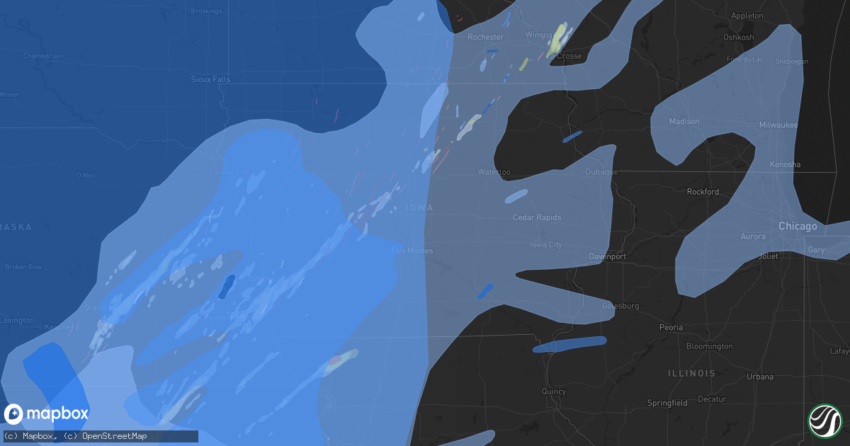
Hail Map in Iowa on December 15, 2021
Get this storm
December 15 map
$229
one time, instant access
Download today. No call, no setup
Keep the $229
Bought the map and want the full workflow? Apply the entire $229 to a subscription within 7 days. None of it is wasted.
Every map, not just this one
This buys you this map. Subscription and you get every map we run, in the markets you choose from a few cities to whole states to nationwide. Plus real-time alerts the moment a storm fires.
Contact data
Name, contact info, occupancy, even credit band for addresses in the footprint. You go from where it hit to who to call.
Become the source they trust
Unlimited branding weather history reports on demand. You already have the documented answer ready for the property owner, and you are the one who showed up with it.
Property data and RoofTrace estimates
Pull up any address you have got, its value and the exact code rules for that jurisdiction, straight from One Click Code. Then RoofTrace estimates the squares, pitch, and roof value, priced the way you price.
Storm reports in Iowa
Iowa
| Date | Description |
|---|---|
| 12/15/20215:56 PM CST | Tree down on power line and house. Time estimated from radar. |
| 12/15/20215:56 PM CST | Em reports several trees down in creston... Affecting traffic and power lines. Time estimated from radar. |
| 12/15/20215:55 PM CST | At creston airport... Kcsq awos 61 kts. |
| 12/15/20215:52 PM CST | Large branches down and shingles off of roof. Garage blown off of foundation. Time estimated from radar. |
| 12/15/20215:51 PM CST | Metal roof peeled off on the tek builders building in mt ayr. Delayed report. Time estimated via radar. |
| 12/15/20215:51 PM CST | Powerlines and poles... Outbuilding and tree damage starting near harcourt and extending northeast towards duncombe in webster county. |
| 12/15/20215:49 PM CST | Power poles down in town. Time estimated from radar. |
| 12/15/20215:49 PM CST | Location estimated by radar. Report via social media with video evidence. Unknown damage. Delayed report. |
| 12/15/20215:49 PM CST | Emergency manager relayed building/debris blown onto highway 175. Time estimated from radar. |
| 12/15/20215:49 PM CST | Em reports 80 mph winds hwy 169 and hwy 44. |
| 12/15/20215:48 PM CST | Machine shed damaged 1 mile north of somers and stop signs/highway signs blown over hwy 20 at knierim. |
| 12/15/20215:48 PM CST | Machine shed damaged 1 mile north of somers an: heavy damage to machine sheds and out buildings via social media video. |
| 12/15/20215:45 PM CST | 3 sw minburn est 75 mph. |
| 12/15/20215:45 PM CST | Hog building completely destroyed. |
| 12/15/20215:45 PM CST | Dialed into perry awos. |
| 12/15/20215:45 PM CST | Damage to farmstead buildings northeast of jefferson near intersection of 195th and r ave. Time estimated by radar. Report via social media. |
| 12/15/20215:45 PM CST | Damage to outbuilding and trees uprooted. Time estimated from radar. |
| 12/15/20215:42 PM CST | Extensive building damage to the northeast of ayrshir. |
| 12/15/20215:41 PM CST | 60 to 70 mph wind gust reports from amateur radio operators in perry. |
| 12/15/20215:41 PM CST | Damage to power poles along highway 30 west of jefferson. Report via social media. Delayed report and time/location estimated by radar. |
| 12/15/20215:41 PM CST | 60-70 mph wind gust reports from amateur radio operators in minburn. |
| 12/15/20215:40 PM CST | Roof gone off of a large shed... 2-3 trees uprooted and several power poles were knocked down. Time estimated from radar. |
| 12/15/20215:39 PM CST | Pws recorded 62 mph wind gusts. |
| 12/15/20215:39 PM CST | Public relayed siding missing on house on se side of grand junction. Time estimated from radar. |
| 12/15/20215:35 PM CST | A local report indicates 60 MPH wind near 8 WSW MILFORD |
| 12/15/20215:35 PM CST | Outbuilding destroyed at 240th st. And timber ave. Size of building unknown. |
| 12/15/20215:34 PM CST | Public relayed possible tornado damage west of jefferson... Including large portion of garage damaged/missing. Time estimated from radar. |
| 12/15/20215:34 PM CST | Out buildings blown over... Houses damaged... Power lines down... Gas leak - tds noted in the area on radar. |
| 12/15/20215:34 PM CST | Semi rollover. I-29n at 35 mm. |
| 12/15/20215:32 PM CST | Report of an outbuilding destroyed. |
| 12/15/20215:31 PM CST | Trees down in town. Time estimated from radar. |
| 12/15/20215:31 PM CST | Wind estimates of at least 70 mph from ralston fire dept. Some sporadic damage beginning to occur. |
| 12/15/20215:27 PM CST | Pws recorded wind gust of 73 mph. |
| 12/15/20215:27 PM CST | Lamoni municipal airport recorded 52 kt wind gust. |
| 12/15/20215:27 PM CST | A local report indicates 70 MPH wind near COON RAPIDS |
| 12/15/20215:25 PM CST | A local report indicates 73 MPH wind near 4 NE GUTHRIE CENTER |
| 12/15/20215:25 PM CST | Large pine tree blow down. Time estimated from radar. |
| 12/15/20215:24 PM CST | Tree on road ia-92 at 8 mm & eastern hills drive. |
| 12/15/20215:23 PM CST | A local report indicates 1.00 inch wind near COON RAPIDS |
| 12/15/20215:22 PM CST | Tree on roadway. Us-6 38 mm. |
| 12/15/20215:17 PM CST | Em reports 1/2 inch hail and estimated 65 mph wind... Hwy 44 and frontier road in guthrie co. |
| 12/15/20215:15 PM CST | Em reports 80+ mph winds... Zero visibility south of adair. |
| 12/15/20215:15 PM CST | A local report indicates 61 MPH wind near 1 SSE CLARINDA |
| 12/15/20215:12 PM CST | Pws recorded a 76 mph wind gust. |
| 12/15/20215:11 PM CST | Large tree branch down in town. Time estimated from radar. |
| 12/15/20215:11 PM CST | Pws recorded wind gust of 88 mph. |
| 12/15/20215:10 PM CST | Destroyed building blocking highway 10 south of sutherland. Time estimated from radar. |
| 12/15/20215:07 PM CST | Delayed report. Pictures came in via email east of hamlin... Ia. Time estimated based on radar and other reports in audubon county. |
| 12/15/20215:04 PM CST | Damage to machine sheds and some roofs damage. Time estimated from radar. |
| 12/15/20215:04 PM CST | Corrects previous tornado report from exira. Damage to multiple to barn buildings near exira. Delayed report via social media photos. Time estimated via radar. |
| 12/15/20215:03 PM CST | Silo damaged... Trees down and sheet metal from buildings on road. Power out in town. Time estimated from radar. |
| 12/15/20215:03 PM CST | Updates previous tstm wnd dmg report from aurelia. Silo damaged... Trees down and sheet metal from buildings on road. 3 rail cars blown over... And a home destroyed. Po |
| 12/15/20215:02 PM CST | Storm chaser reported tornado on the west side of atlantic. |
| 12/15/20215:02 PM CST | Semi rolled over. I-80w 13 mm near mcclelland... Ia. |
| 12/15/20215:01 PM CST | Storm chaser reported flipped semis on i-80 and power flashes associated with a tornado. |
| 12/15/20215:00 PM CST | Power lines across highway 34. |
| 12/15/20215:00 PM CST | Powerlines down. |
| 12/15/20214:57 PM CST | House damaged with roof torn off. Hoop barn destroyed and 100 year old marchine shed destoyed. Time estimated from radar. |
| 12/15/20214:56 PM CST | Roofs were blown off of a few buildings and semi was blown off the road. Time estimated from radar. |
| 12/15/20214:55 PM CST | Awos station kdns denison airport. |
| 12/15/20214:55 PM CST | A local report indicates 72 MPH wind near HARLAN |
| 12/15/20214:53 PM CST | Trees uprooted or snapped; roof blown off. |
| 12/15/20214:53 PM CST | Semi rolled over on i-80w per twitter photo. |
| 12/15/20214:52 PM CST | Machine shed destroyed and gravity wagon tipped over. Report via social media. |
| 12/15/20214:50 PM CST | Trees down. Time estimated from radar. |
| 12/15/20214:50 PM CST | Mesonet station ravi4 avoca |
| 12/15/20214:48 PM CST | Machine shed damage. Time estimated from radar. |
| 12/15/20214:43 PM CST | Machine shed damaged. Time estimated from radar. |
| 12/15/20214:41 PM CST | Large tree fell on home. |
| 12/15/20214:40 PM CST | Machine shed destroyed. |
| 12/15/20214:38 PM CST | Large garage doors on city building blown in. |
| 12/15/20214:38 PM CST | A local report indicates 80 MPH wind near 2 SE UNDERWOOD |
| 12/15/20214:36 PM CST | A local report indicates 79 MPH wind near 5 ENE COUNCIL BLUFFS |
| 12/15/20214:35 PM CST | Roof town off of building. Time estimated from radar. |
| 12/15/20214:34 PM CST | Cattle barn and garage damaged. Time estimated from radar. |
| 12/15/20214:34 PM CST | Delayed report... Time estimated from radar. Report from mping: trees uprooted or snapped; roof blown off. |
| 12/15/20214:33 PM CST | Report of power flashes from power lines. |
| 12/15/20214:32 PM CST | From video and tds. Tornado on the ground for at least 2 minutes. Damage reported in neola. |
| 12/15/20214:31 PM CST | Power lines down across hwy 20. Time estimated from radar. |
| 12/15/20214:31 PM CST | Pole shed roof off with debris blown into field. Time estimated from radar. |
| 12/15/20214:29 PM CST | Roof blown off a house on l-34 west of underwood. |
| 12/15/20214:29 PM CST | Large tree on house. |
| 12/15/20214:27 PM CST | Powerlines down. |
| 12/15/20214:25 PM CST | Major home damage in weston. |
| 12/15/20214:24 PM CST | Damage to building. |
| 12/15/20214:24 PM CST | Fire chief reported power lines and poles down for about a 1/4 mile from homestead ave to l-34 along railroad highway. |
| 12/15/20214:23 PM CST | A local report indicates 82 MPH wind near 1 WSW SERGEANT BLUFF |
| 12/15/20214:22 PM CST | Mesonet station up118 2.2 w missouri valley |
| 12/15/20214:22 PM CST | Power lines across highway 34. |
| 12/15/20214:22 PM CST | A local report indicates 83 MPH wind near MISSOURI VALLEY |
| 12/15/20214:22 PM CST | Mesonet station near sidney at i29/hwy 2. |
| 12/15/20214:21 PM CST | Nine loaded coal cars rolled off tracks. |
| 12/15/20214:21 PM CST | Roofs off a couple of homes between sergeant bluff and bronson. Time estimated from radar. |
| 12/15/20214:20 PM CST | Mesonet station rcbi4 council bluffs |
| 12/15/20214:20 PM CST | Building damaged. Time estimated from radar. |
| 12/15/20214:19 PM CST | Overturned propane tanks. Time estimated from radar. |
| 12/15/20214:17 PM CST | A local report indicates a tornado near 2 S SALIX |
| 12/15/20214:17 PM CST | A local report indicates a tornado near 2 SW BRONSON |
| 12/15/20218:38 AM CST | Spotterr estimated wind gust of 80 mph but no was damage noted. Also reported several 60 mph gusts around that time frame. |
| 12/15/20213:14 AM CST | At 913 PM CST, severe thunderstorms were located along a line extending from Toolesboro to near West Point, moving east at 50 mph. HAZARD...70 mph wind gusts. SOURCE...Radar indicated. IMPACT...Expect considerable tree damage. Damage is likely to mobile homes, roofs, and outbuildings. Locations impacted include... Galesburg, Macomb, Monmouth, Aledo, Bushnell, Burgess, Colchester, Roseville, Viola, Stronghurst, Avon, Millersburg, Matherville, Kirkwood, New Boston, Blandinsville, Sherrard, Keithsburg, Reynolds and Industry. |
| 12/15/20213:08 AM CST | At 908 PM CST, severe thunderstorms were located along a line extending from near Viroqua to near Bankston, moving east at 50 mph. HAZARD...70 mph wind gusts. SOURCE...Radar indicated. IMPACT...Expect considerable tree damage. Damage is likely to mobile homes, roofs, and outbuildings. Severe thunderstorms will be near... Dubuque around 920 PM CST. Dickeyville around 935 PM CST. Cuba City and Hazel Green around 945 PM CST.Other locations impacted by these severe thunderstorms includeArthur, Highway 61 And County T, Montfort, Eagle Corners, Highway 80And County C C, Woodstock and Gillingham. |
| 12/15/20212:44 AM CST | At 844 PM CST, severe thunderstorms were located along a line extending from near Edgewood to near Bertram, moving northeast at 55 mph. HAZARD...70 mph wind gusts. SOURCE...Radar indicated. IMPACT...Expect considerable tree damage. Damage is likely to mobile homes, roofs, and outbuildings. Severe thunderstorms will be near... Greeley around 850 PM CST. Colesburg and Stone City around 855 PM CST. Anamosa around 900 PM CST.Other locations in the path of these severe thunderstorms includeOlin, Langworthy, Center Junction, Wyoming, Onslow and Canton. |
| 12/15/20212:29 AM CST | At 829 PM CST, severe thunderstorms were located along a line extending from New Albin to near Postville to Strawberry Point, moving northeast at 65 mph. HAZARD...70 mph wind gusts. SOURCE...Radar indicated. IMPACT...Expect considerable tree damage. Damage is likely to mobile homes, roofs, and outbuildings. Severe thunderstorms will be near... Elkader around 840 PM CST.Other locations impacted by these severe thunderstorms includeHanover, Volney, County Roads A 52 And W 60, State Road 76 And CountyX 16, Mederville, Elon and Quandahl. |
| 12/15/20212:23 AM CST | At 823 PM CST, severe thunderstorms were located along a line extending from near Vinton to near Williamsburg, moving northeast at 55 mph. HAZARD...70 mph wind gusts and penny size hail. SOURCE...Radar indicated. IMPACT...Expect considerable tree damage. Damage is likely to mobile homes, roofs, and outbuildings. Locations impacted include... Vinton, Marengo, Williamsburg, Atkins, Walford, Urbana, North English, Shellsburg, Newhall, Blairstown, Van Horne, Norway, Parnell, Amana, Conroy, Middle Amana, Vinton Memorial Airport, Upper South Amana, East Amana and High Amana. |
| 12/15/20212:08 AM CST | At 808 PM CST, severe thunderstorms were located along a line extending from near Hazleton to 8 miles southeast of Harper, moving east at 65 mph. HAZARD...70 mph wind gusts and penny size hail. SOURCE...Radar indicated. IMPACT...Expect considerable tree damage. Damage is likely to mobile homes, roofs, and outbuildings. Locations impacted include... Cedar Rapids, Iowa City, Washington, Manchester, Columbus Junction, Marion, Coralville, North Liberty, Hiawatha, Mount Vernon, Robins, Center Point, Kalona, Lisbon, Fairfax, Solon, Tiffin, Ely, Walford and Wellman. |
| 12/15/20211:53 AM CST | At 752 PM CST, severe thunderstorms were located along a line extending from near Wanamingo to 7 miles southwest of Lewiston to near Mabel, moving northeast at 80 mph. THESE ARE DESTRUCTIVE STORMS. HAZARD...80 mph wind gusts. SOURCE...Radar indicated. IMPACT...Flying debris will be dangerous to those caught without shelter. Mobile homes will be heavily damaged. Expect considerable damage to roofs, windows, and vehicles. Extensive tree damage and power outages are likely. Severe thunderstorms will be near... Stockton and Altura around 800 PM CST. Winona, Goodview, Fountain City and Rollingstone around 805 PM CST. Houston around 810 PM CST.Other locations in the path of these severe thunderstorms includeDakota, Trempealeau, Independence, Brice Prairie, Galesville, Strum,Whitehall and Blair. |
| 12/15/20211:44 AM CST | At 743 PM CST, severe thunderstorms were located along a line extending from near Shell Rock to near Belle Plaine, moving northeast at 75 mph. HAZARD...70 mph wind gusts. SOURCE...Trained weather spotters. IMPACT...Expect considerable tree damage. Damage is likely to mobile homes, roofs, and outbuildings. Severe thunderstorms will be near... Waverly around 750 PM CST.This includes Interstate 380 between mile markers 56 and 73. |
| 12/15/20211:33 AM CST | At 733 PM CST, severe thunderstorms were located along a line extending from Denver to 7 miles southeast of Hudson, moving northeast at 45 mph. HAZARD...70 mph wind gusts. SOURCE...Radar indicated. IMPACT...Expect considerable tree damage. Damage is likely to mobile homes, roofs, and outbuildings. Severe thunderstorms will be near... Fairbank around 750 PM CST.Other locations in the path of these severe thunderstorms includeJesup, Independence, Winthrop, Hazleton, Stanley, Aurora and Lamont. |
| 12/15/20211:24 AM CST | At 723 PM CST, severe thunderstorms were located along a line extending from near Blooming Prairie to 6 miles north of Le Roy to 7 miles north of Jerico, moving north at 85 mph. HAZARD...70 mph wind gusts. SOURCE...Radar indicated. IMPACT...Expect considerable tree damage. Damage is likely to mobile homes, roofs, and outbuildings. Severe thunderstorms will be near... Hayfield around 730 PM CST. Dodge Center, Mantorville, Kasson, Stewartville and Claremont around 735 PM CST. Harmony and West Concord around 740 PM CST. |
| 12/15/20211:17 AM CST | At 716 PM CST, severe thunderstorms were located along a line extending from 6 miles southeast of Marshalltown to 9 miles south of Grinnell to near New Sharon, moving northeast at 60 mph. THESE ARE DESTRUCTIVE STORMS FOR PORTIONS OF EASTERN IOWA. HAZARD...80 mph wind gusts and penny size hail. SOURCE...Radar indicated. IMPACT...Flying debris will be dangerous to those caught without shelter. Mobile homes will be heavily damaged. Expect considerable damage to roofs, windows, and vehicles. Extensive tree damage and power outages are likely. Locations impacted include... Vinton, Marengo, Williamsburg, Belle Plaine, Atkins, Walford, Urbana, Dysart, North English, Shellsburg, Victor, Newhall, Blairstown, Van Horne, Keystone, Norway, Garrison, Ladora, Parnell and Millersburg. |
| 12/15/20211:03 AM CST | At 702 PM CST, severe thunderstorms were located along a line extending from 13 miles east of Princeton to near Chillicothe to 8 miles north of Norborne, moving northeast at 85 mph. HAZARD...70 mph wind gusts. SOURCE...Radar indicated. IMPACT...Expect considerable tree damage. Damage is likely to mobile homes, roofs, and outbuildings. Locations impacted include... Kirksville, Moberly, Chillicothe, Macon, Brookfield, Carrollton, Marceline, Milan, Unionville, Salisbury, Huntsville, La Plata, Lancaster, Brunswick, Bevier, Green City, Queen City, Keytesville, Bucklin and Meadville. |
| 12/15/202112:47 AM CST | At 646 PM CST, severe thunderstorms were located along a line extending from near Aplington to 8 miles southeast of State Center, moving east at 55 mph. HAZARD...70 mph wind gusts. SOURCE...Radar indicated. IMPACT...Expect considerable tree damage. Damage is likely to mobile homes, roofs, and outbuildings. Severe thunderstorms will be near... Marshalltown around 700 PM CST. |
| 12/15/202112:24 AM CST | At 623 PM CST, severe thunderstorms were located along a line extending from Slater to near New Virginia, moving east at 75 mph. HAZARD...70 mph wind gusts. SOURCE...Radar indicated. IMPACT...Expect considerable tree damage. Damage is likely to mobile homes, roofs, and outbuildings. Severe thunderstorms will be near... Melcher-Dallas around 640 PM CST.Other locations in the path of these severe thunderstorms includeBaxter and Rock Creek Lake.This includes the following highways... Interstate 35 between mile markers 39 and 72, and between milemarkers 87 and 101. Interstate 80 between mile markers 118 and 189. Interstate 235 between mile markers 1 and 14. |
| 12/15/202112:24 AM CST | At 623 PM CST, a severe thunderstorm was located over Bethany, moving northeast at 65 mph. HAZARD...70 mph wind gusts and penny size hail. SOURCE...Radar indicated. IMPACT...Expect considerable tree damage. Damage is likely to mobile homes, roofs, and outbuildings. Locations impacted include... Trenton, Bethany, Milan, Gallatin, Princeton, Jamesport, Ridgeway, Gilman City, Pattonsburg, Mercer, Eagleville, Cainsville, Spickard, Galt, Winston, Altamont, Laredo, Blythedale, Newtown and Coffey.This includes Interstate 35 in Missouri between mile markers 57 and114. |
| 12/15/202112:13 AM CST | At 613 PM CST, severe thunderstorms were located along a line extending from near New Virginia to 7 miles southeast of Lamoni, moving east at 50 mph. HAZARD...60 mph wind gusts. SOURCE...Radar indicated. IMPACT...Expect damage to roofs, siding, and trees. These severe thunderstorms will remain over mainly rural areas of western Monroe, Lucas, Decatur, southwestern Marion, Wayne, western Appanoose, Clarke and southern Warren Counties, including the following locations... Melrose, Red Haw Lake State Park, Pleasanton, Promise City, Clio, Williamson, Nine Eagles State Park, Decatur City, Humeston and Lineville.This includes Interstate 35 between mile markers 4 and 44. |
| 12/14/202111:29 PM CST | At 528 PM CST, severe thunderstorms were located along a line extending from 8 miles south of Harris to near Lost Island Lake, moving north at 70 mph. HAZARD...70 mph wind gusts and penny size hail. SOURCE...Radar indicated. IMPACT...Expect considerable tree damage. Damage is likely to mobile homes, roofs, and outbuildings. Severe thunderstorms will be near... Lake Park and Terril around 535 PM CST. Superior around 545 PM CST. Jackson around 555 PM CST. Other locations in the path of these severe thunderstorms includeLakefield. |
| 12/14/202111:17 PM CST | Waterloo asos. |
| 12/14/202111:10 PM CST | At 509 PM CST, severe thunderstorms were located along a line extending from near Coon Rapids to 8 miles north of Lake Icaria, moving east at 80 mph. THESE ARE DESTRUCTIVE STORMS FOR CENTRAL IOWA. HAZARD...80 mph wind gusts. SOURCE...Radar indicated. IMPACT...Flying debris will be dangerous to those caught without shelter. Mobile homes will be heavily damaged. Expect considerable damage to roofs, windows, and vehicles. Extensive tree damage and power outages are likely. Locations impacted include... Des Moines, West Des Moines, Ankeny, Urbandale, Johnston, Clive, Indianola, Altoona, Waukee, Norwalk, Pleasant Hill, Grimes, Perry, Winterset, Adel, Greenfield, Guthrie Center, Windsor Heights, Carlisle and Bondurant.This includes the following highways... Interstate 35 between mile markers 43 and 72, and between milemarkers 87 and 107. Interstate 80 between mile markers 73 and 149. Interstate 235 between mile markers 1 and 14. |
| 12/14/202110:56 PM CST | At 455 PM CST, severe thunderstorms were located along a line extending from near Paullina to Cherokee to near Galva, moving northeast at 70 mph. HAZARD...80 mph wind gusts. SOURCE...Radar indicated. IMPACT...Flying debris will be dangerous to those caught without shelter. Mobile homes will be heavily damaged. Expect considerable damage to roofs, windows, and vehicles. Extensive tree damage and power outages are likely. Severe thunderstorms will be near... Larrabee around 500 PM CST. Storm Lake, Alta, Lakeside, Peterson and Linn Grove around 510 PM CST. Royal and Truesdale around 515 PM CST.Other locations in the path of these severe thunderstorms includeEverly, Greenville, Spencer In Clay County, Albert City, Marathon,Fostoria, Webb and Lost Island Lake. |
| 12/14/202110:55 PM CST | Algona awos. |
| 12/14/202110:39 PM CST | Marshalltown asos. |
| 12/14/202110:37 PM CST | Waterloo asos. |
| 12/14/202110:16 PM CST | At 414 PM CST, severe thunderstorms were located along a line extending from near Salix to near Modale, moving northeast at 65 mph. THESE ARE DESTRUCTIVE STORMS FOR WEST CENTRAL IOWA. HAZARD...80 mph wind gusts. SOURCE...Emergency management. IMPACT...Flying debris will be dangerous to those caught without shelter. Mobile homes will be heavily damaged. Expect considerable damage to roofs, windows, and vehicles. Extensive tree damage and power outages are likely. Locations impacted include... Denison and Carroll. |
| 12/14/20219:41 PM CST | At 340 PM CST, severe thunderstorms were located along a line extending from 4 miles northwest of Wisner to near West Point to 6 miles northeast of North Bend, moving northeast at 80 mph. THESE ARE DESTRUCTIVE STORMS! HAZARD...80 mph wind gusts and nickel size hail. SOURCE...Trained weather spotters and emergency management have reported widespread wind damage and measured winds to 80 mph with these storms. IMPACT...Flying debris will be dangerous to those caught without shelter. Mobile homes will be heavily damaged. Expect considerable damage to roofs, windows, and vehicles. Extensive tree damage and power outages are likely. Severe thunderstorms will be near... Pender around 350 PM CST. Lyons, Emerson and Bancroft around 355 PM CST. Walthill, Craig and Macy around 400 PM CST.Other locations in the path of these severe thunderstorms includeTekamah, Whiting, Decatur and Onawa.This includes Interstate 29 between mile markers 84 and 125. |
| 12/14/20219:40 PM CST | A local report indicates 60 MPH wind near 3 SE MAYSVILLE |
| 12/14/20219:39 PM CST | Power poles broken. |
| 12/14/20219:38 PM CST | Power poles broken. |
| 12/14/20219:30 PM CST | Tree down on roadway about 3 w of columbus junction. |
| 12/14/20219:27 PM CST | A local report indicates 60 MPH wind near 4 NNE MUSCATINE |
| 12/14/20219:25 PM CST | A local report indicates 70 MPH wind near LOWDEN |
| 12/14/20219:24 PM CST | Power poles broken. |
| 12/14/20219:22 PM CST | Shed blown down and skirting blown off a mobile home. |
| 12/14/20219:20 PM CST | Several 3-4 inch diameter branches down. |
| 12/14/20219:19 PM CST | Tree down on power lines. Time estimated by radar. |
| 12/14/20219:13 PM CST | Part of a building blown into the roadway. |
| 12/14/20219:10 PM CST | A local report indicates 60 MPH wind near KEOKUK |
| 12/14/20219:06 PM CST | A local report indicates 58 MPH wind near KEOKUK AIRPORT |
| 12/14/20219:03 PM CST | Delayed report. Iadot rwis. |
| 12/14/20219:00 PM CST | Power out. |
| 12/14/20218:57 PM CST | A local report indicates 60 MPH wind near 1 ENE TIFFIN |
| 12/14/20218:55 PM CST | A local report indicates 60 MPH wind near MOUNT PLEASANT MUNICIPA |
| 12/14/20218:54 PM CST | A local report indicates 70 MPH wind near 2 SE IOWA CITY |
| 12/14/20218:52 PM CST | A local report indicates 70 MPH wind near IOWA CITY MUNICIPALITY |
| 12/14/20218:52 PM CST | A local report indicates 64 MPH wind near 2 SSW WILLIAMSTOWN |
| 12/14/20218:49 PM CST | House and roof damage in greeley and oneida. |
| 12/14/20218:48 PM CST | Shingle damage reported as well as other damage in the neighborhood. |
| 12/14/20218:45 PM CST | Tree down on house. Time estimated by radar. |
| 12/14/20218:42 PM CST | Estimated 70 mph wind gust knocked down a tin shed. |
| 12/14/20218:38 PM CST | Corrects the time from the previous tstm wnd gst report from hiawatha. Spotterr estimated wind gust of 80 mph but no was damage noted. Also reported several 60 mph gust |
| 12/14/20218:32 PM CST | Thunderstorm winds threw trampoline against house... Causing a metal pole to pierce the siding and enter the house. Time is estimated by radar. |
| 12/14/20218:32 PM CST | A local report indicates 65 MPH wind near ATKINS |
| 12/14/20218:30 PM CST | *** 1 fatal *** severe thunderstorms winds caused a semi-trailer blow-over. The driver was thrown from the vehicle and pronounced dead at the scene. |
| 12/14/20218:30 PM CST | A local report indicates 66 MPH wind near CEDAR RAPIDS MUNICIPALI |
| 12/14/20218:26 PM CST | Report relayed by em. |
| 12/14/20218:25 PM CST | Multiple trees down. |
| 12/14/20218:24 PM CST | Report relayed by em. |
| 12/14/20218:23 PM CST | Tree down. Time estimated from radar. |
| 12/14/20218:20 PM CST | Corrects time of previous tstm wnd dmg report from 3 w mount sterling. Several 3-4 inch diameter branches down. |
| 12/14/20218:20 PM CST | A local report indicates 76 MPH wind near 2 SW CHENEY |
| 12/14/20218:13 PM CST | Tree down over highway 150. |
| 12/14/20218:13 PM CST | Tree reported down in stanley. Time estimated from radar. |
| 12/14/20218:02 PM CST | Report relayed from em. |
| 12/14/20217:54 PM CST | Peak wind gust at ottumwa |
| 12/14/20217:52 PM CST | Reported at oskaloosa municipal airport. |
| 12/14/20217:37 PM CST | Power outages reported. |
| 12/14/20217:37 PM CST | Power outages reported |
| 12/14/20217:36 PM CST | Waterloo municipal airport asos recorded 54 kt wind gust. |
| 12/14/20217:34 PM CST | A local report indicates 61 MPH wind near WATERLOO REGIONAL AIRPO |
| 12/14/20217:31 PM CST | Mesonet station nswi4 neil smith nwr. |
| 12/14/20217:30 PM CST | Major damage sustained by large outbuilding southwest of cresco. Also major structural damage at a nearby hog farm. Time estimated from radar. |
| 12/14/20217:28 PM CST | Trees uprooted... Power poles snapped and metal barn roof partially blown off. Report via twitter. Time estimated. |
| 12/14/20217:27 PM CST | 60-70 mph wind near centerville. Report via social media and time estimated by radar. |
| 12/14/20217:25 PM CST | 2 semis overturned on i80 wb near the 185 to 186 mm... Just east of grinnell. |
| 12/14/20217:20 PM CST | Report from mping: trees uprooted or snapped; roof blown off. |
| 12/14/20217:20 PM CST | Iowa dot sensor. |
| 12/14/20217:20 PM CST | Large tree partially uprooted and on a home... Metal building flipped. Time estimated via radar. |
| 12/14/20217:20 PM CST | Mesonet station rnhi4 2 n ionia. |
| 12/14/20217:16 PM CST | Spotter reports 60 to 70 mph winds and power flashes. Relayed report from dvn. |
| 12/14/20217:15 PM CST | Peak wind gust from kpea. |
| 12/14/20217:15 PM CST | Snapped power poles. Time estimated via radar. |
| 12/14/20217:15 PM CST | Damage to railroad tracks. |
| 12/14/20217:09 PM CST | Nickel to quarter sized hail reported. |
| 12/14/20217:06 PM CST | Reports of flattened farm buildings. |
| 12/14/20217:05 PM CST | Large limbs down and metal roof blown off. Time estimated via radar. |
| 12/14/20217:03 PM CST | Roof off of a garage and an outbuilding tipped on its side. Report from broadcast media. Time estimated via radar. |
| 12/14/20217:00 PM CST | Roof on hwy 27 near park entrance. |
| 12/14/20217:00 PM CST | Overturned semi-truck trailer at truck stop. |
| 12/14/20217:00 PM CST | Numerous reports of wind damage to houses. |
| 12/14/20216:55 PM CST | Awos station koxv knoxville airport. |
| 12/14/20216:55 PM CST | Damage to shed or outbuilding east of manly. Report via social media. Time estimated by radar. |
| 12/14/20216:53 PM CST | A local report indicates 83 MPH wind near 3 NE CLEAR LAKE |
| 12/14/20216:48 PM CST | Multiple 3 inch diameter or greater tree branches down. Time estimated from radar. |
| 12/14/20216:48 PM CST | Peak wind at kcnc. |
| 12/14/20216:47 PM CST | One out building leveled and another missing the north wall. Time estimated by radar. |
| 12/14/20216:40 PM CST | Delayed report mn 4378 9248 trees uprooted and large branches blown down. Report via twitter. |
| 12/14/20216:40 PM CST | Delayed report: heavy damage to machine sheds and out buildings via social media video. |
| 12/14/20216:38 PM CST | Personal weather station. |
| 12/14/20216:37 PM CST | Local trained spotters reporting numerous trees down and wind gusts 65-70mph. |
| 12/14/20216:36 PM CST | Numerous trees down blocking 65/69 700 blk s. Jefferson way. Other trees down in indianola. |
| 12/14/20216:35 PM CST | Awos station kikv ankeny airport. |
| 12/14/20216:32 PM CST | Quarter size hail reported at hwy 3 and interstate 35. |
| 12/14/20216:29 PM CST | A local report indicates 60 MPH wind near 5 ENE OSCEOLA |
| 12/14/20216:28 PM CST | Phone pole damage at wakonda golf course. Report from broadcast media. Time estimated by radar. |
| 12/14/20216:27 PM CST | A local report indicates 75 MPH wind near 1 WNW JOHNSTON |
| 12/14/20216:27 PM CST | A local report indicates 61 MPH wind near DES MOINES INT AIRPORT |
| 12/14/20216:27 PM CST | Large tree on home. Time estimated via radar. |
| 12/14/20216:25 PM CST | 3 to 4 outbuildings completely destroyed near belmond. Time estimated by radar. |
| 12/14/20216:25 PM CST | A local report indicates 67 MPH wind near 2 ENE LAMONI |
| 12/14/20216:23 PM CST | Siding... Shingle... And minor tree damage to townhomes. Report via broadcast media. Time estimated via radar. |
| 12/14/20216:23 PM CST | Barn wall collapsed... Tree damage. Report from broadcast media. Time estimated via radar. |
| 12/14/20216:20 PM CST | Large tree down on house in clive. Time estimated from radar. |
| 12/14/20216:19 PM CST | Measured via cwop. |
| 12/14/20216:18 PM CST | Trees down on power lines in osceola. Time estimated from radar. |
| 12/14/20216:17 PM CST | Former nws employee. Power out for a short stint. |
| 12/14/20216:15 PM CST | A local report indicates 67 MPH wind near 2 WNW ALGONA |
| 12/14/20216:15 PM CST | 14 inch diameter tree on house. |
| 12/14/20216:15 PM CST | A local report indicates 62 MPH wind near 2 W ALGONA |
| 12/14/20216:13 PM CST | A local report indicates 70 MPH wind near GILBERT |
| 12/14/20216:12 PM CST | Wind gusts 612 to 625 pm estimated 60-70 mph with large branches down... Exact size unknown. |
| 12/14/20216:12 PM CST | Tornado confirmed... Approx 6 miles south of algona. |
| 12/14/20216:08 PM CST | A local report indicates 58 MPH wind near 2 S AMES |
| 12/14/20216:07 PM CST | A local report indicates 65 MPH wind near 1 WNW JOHNSTON |
| 12/14/20216:02 PM CST | A local report indicates 73 MPH wind near 3 NNW FORT DODGE |
| 12/14/20216:00 PM CST | Public reported tornado on the ground. No additional information at this time. |
All States Impacted by Hail Map on December 15, 2021
Cities Impacted by Hail Map on December 15, 2021
- Nowata, OK
- Delaware, OK
- Americus, KS
- Emporia, KS
- Uniontown, KS
- Redfield, KS
- Whitewater, KS
- Newton, KS
- Mapleton, KS
- Fort Scott, KS
- Moran, KS
- Fulton, KS
- Bronson, KS
- Odebolt, IA
- Holmen, WI
- Axtell, KS
- Pawnee City, NE
- Burchard, NE
- Plattsmouth, NE
- Pacific Junction, IA
- Glenwood, IA
- Murray, NE
- Savonburg, KS
- Fall River, KS
- Fredonia, KS
- Toronto, KS
- Saint Edward, NE
- Fullerton, NE
- Belgrade, NE
- Oakland, IA
- Carson, IA
- Onaga, KS
- Ayr, NE
- Hastings, NE
- Avoca, NE
- Weeping Water, NE
- Elmwood, NE
- Neodesha, KS
- Ottawa, KS
- Onalaska, WI
- Burns, KS
- Osceola, NE
- Giltner, NE
- Hordville, NE
- Marquette, NE
- Stromsburg, NE
- Phillips, NE
- Polk, NE
- Aurora, NE
- Doniphan, NE
- Silver Creek, NE
- Clarks, NE
- Ogden, IA
- Milford, NE
- Dorchester, NE
- Winfield, KS
- Stark, KS
- Prague, NE
- Bruno, NE
- Springfield, NE
- Eagle, NE
- Gretna, NE
- Papillion, NE
- Murdock, NE
- Omaha, NE
- Louisville, NE
- Alvo, NE
- Ashland, NE
- Elk City, KS
- Olpe, KS
- Strong City, KS
- Greenwood, NE
- Pleasant Dale, NE
- Lincoln, NE
- Friend, NE
- Leigh, NE
- Monroe, NE
- Duncan, NE
- Hampton, NE
- Trumbull, NE
- Clarkson, NE
- Shelby, NE
- Columbus, NE
- Arcadia, KS
- Walnut, KS
- Bronaugh, MO
- Erie, KS
- Saint Paul, KS
- Farlington, KS
- Girard, KS
- Liberal, MO
- Hepler, KS
- Morrowville, KS
- Clifton, KS
- Mound City, MO
- Skidmore, MO
- Barnard, MO
- Ravenwood, MO
- Maryville, MO
- Graham, MO
- Maitland, MO
- Clyde, MO
- Conception Junction, MO
- Pierson, IA
- Bronson, IA
- Hornick, IA
- Climbing Hill, IA
- Sloan, IA
- Correctionville, IA
- Kingsley, IA
- Moville, IA
- Anthon, IA
- Salix, IA
- Jefferson, IA
- Augusta, KS
- Bartlesville, OK
- Nehawka, NE
- Carroll, IA
- Scranton, IA
- Cambridge, KS
- Latham, KS
- Burden, KS
- Atlanta, KS
- Trempealeau, WI
- Galesville, WI
- Dakota, MN
- Roseland, NE
- Bladen, NE
- Linn, KS
- Agenda, KS
- Concordia, KS
- Washington, KS
- Clyde, KS
- Hollenberg, KS
- Haddam, KS
- Missouri Valley, IA
- Humboldt, KS
- La Harpe, KS
- Iola, KS
- Yates Center, KS
- Coon Rapids, IA
- Exira, IA
- Hamlin, IA
- Syracuse, NE
- Vassar, KS
- Neosho Rapids, KS
- Lebo, KS
- New Century, KS
- Pomona, KS
- Quenemo, KS
- Wellsville, KS
- Gardner, KS
- Eudora, KS
- Cedar Point, KS
- Lyndon, KS
- Osage City, KS
- Edgerton, KS
- Reading, KS
- Olathe, KS
- Melvern, KS
- Cottonwood Falls, KS
- Baldwin City, KS
- Bennet, NE
- Nebraska City, NE
- Macedonia, IA
- Marne, IA
- Union, NE
- Hancock, IA
- Hastings, IA
- Treynor, IA
- Brayton, IA
- Silver City, IA
- Unadilla, NE
- Council Bluffs, IA
- Mineola, IA
- Offutt Afb, NE
- Dunbar, NE
- Walnut, IA
- Elk Horn, IA
- Bellevue, NE
- Guthrie Center, IA
- Malvern, IA
- Palmyra, NE
- Otoe, NE
- Henderson, IA
- Audubon, IA
- Atlantic, IA
- Bayard, IA
- Edgar, NE
- Williams, IA
- Blairsburg, IA
- David City, NE
- Richards, MO
- Ithaca, NE
- Lincolnville, KS
- Madison, KS
- Palmer, NE
- Essex, IA
- Buffalo, KS
- Fort Calhoun, NE
- Iowa Falls, IA
- Popejoy, IA
- Dows, IA
- Alden, IA
- Hampton, IA
- Filley, NE
- Beatrice, NE
- Blue Springs, NE
- Steele City, NE
- Fairbury, NE
- Belleville, KS
- Odell, NE
- Cuba, KS
- Diller, NE
- Hanover, KS
- Wymore, NE
- Endicott, NE
- Mahaska, KS
- Hooper, NE
- Cedar Bluffs, NE
- Ames, NE
- Fremont, NE
- Onawa, IA
- Whiting, IA
- Decatur, NE
- Macy, NE
- Thayer, KS
- Arma, KS
- Galesburg, KS
- Piedmont, KS
- Severy, KS
- Washta, IA
- Quimby, IA
- Ettrick, WI
- Winona, MN
- La Crescent, MN
- Brainard, NE
- Boone, IA
- Stratford, IA
- Pilot Mound, IA
- Schuyler, NE
- Howard, KS
- Grenola, KS
- Longton, KS
- Moline, KS
- Rock, KS
- Juniata, NE
- Holton, KS
- Waverly, KS
- Dexter, KS
- Burlington, KS
- Hartford, KS
- Talmage, NE
- Powhattan, KS
- Hiawatha, KS
- Salina, KS
- Assaria, KS
- Gypsum, KS
- Solomon, KS
- Chanute, KS
- Bellwood, NE
- Rising City, NE
- Cherryvale, KS
- Dennis, KS
- Parsons, KS
- Havana, KS
- Sedan, KS
- Independence, KS
- Elk Falls, KS
- West Point, NE
- Garnett, KS
- Williamsburg, KS
- White Cloud, KS
- Craig, MO
- Dodge, NE
- Greene, IA
- Charles City, IA
- Marble Rock, IA
- Bristow, IA
- Palmer, KS
- Waverly, NE
- Ceresco, NE
- Bancroft, NE
- Parnell, MO
- Sheridan, MO
- Stanberry, MO
- Walker, MO
- Nevada, MO
- Fort Leavenworth, KS
- Gridley, KS
- Vinita, OK
- Clay Center, KS
- Morganville, KS
- Miltonvale, KS
- Wetmore, KS
- Netawaka, KS
- Grand Island, NE
- Howells, NE
- Saint Paul, NE
- Elsmore, KS
- Scribner, NE
- Havensville, KS
- Admire, KS
- Summerfield, KS
- Nemaha, NE
- Brownville, NE
- Baileyville, KS
- Humboldt, NE
- Table Rock, NE
- Auburn, NE
- Raymond, NE
- Leon, KS
- Aredale, IA
- Rose Hill, KS
- Tobias, NE
- Rogers, NE
- Burr, NE
- Douglas, NE
- Martell, NE
- Crete, NE
- Rodney, IA
- Smithland, IA
- Barnsdall, OK
- Ochelata, OK
- Chapman, NE
- Malcolm, NE
- Davey, NE
- Firth, NE
- Panama, NE
- Hickman, NE
- Adams, NE
- Pickrell, NE
- Panora, IA
- Bagley, IA
- Yale, IA
- Jamaica, IA
- Central City, NE
- Dayton, IA
- Wisner, NE
- Beemer, NE
- Sergeant Bluff, IA
- Goff, KS
- Bennington, NE
- Waterloo, NE
- Elkhorn, NE
- Benedict, NE
- Barnes, KS
- Greenleaf, KS
- Mead, NE
- Yutan, NE
- Stanhope, IA
- Boxholm, IA
- Paton, IA
- York, NE
- Hubbell, NE
- Munden, KS
- Narka, KS
- Melrose, WI
- Derby, KS
- Andover, KS
- Wichita, KS
- Virginia, NE
- Crab Orchard, NE
- Linwood, NE
- Sterling, NE
- Roca, NE
- Horton, KS
- Robinson, KS
- Bolckow, MO
- Forest City, MO
- Oregon, MO
- Grand Junction, IA
- Dana, IA
- Rippey, IA
- North Bend, NE
- Morse Bluff, NE
- Manley, NE
- Charter Oak, IA
- Grimes, IA
- Verdigre, NE
- Milton, KS
- Surprise, NE
- Bondurant, IA
- Counselor, NM
- Pemberton, MN
- Wallingford, IA
- Randall, KS
- Pritchett, CO
- Center, CO
- Vernon Center, MN
- Offerle, KS
- Oberlin, KS
- Branson, CO
- Downs, KS
- Wilsey, KS
- Maybell, CO
- Happy, TX
- Halbur, IA
- Durango, CO
- Barnum, IA
- White River, SD
- Fort Garland, CO
- Tierra Amarilla, NM
- Pierre, SD
- Fulton, SD
- San Jon, NM
- Weldon, IA
- White Owl, SD
- Thoreau, NM
- Danville, KS
- Wentworth, SD
- Bristow, NE
- Rainsville, NM
- Minneota, MN
- Amalia, NM
- Malmo, NE
- Cunningham, KS
- Soldier, IA
- Cimarron, KS
- Hillsboro, KS
- Revere, MN
- Lineville, IA
- Rosalia, KS
- Casa Blanca, NM
- Tabor, IA
- Idaho Springs, CO
- Magnet, NE
- Harveyville, KS
- Box Elder, SD
- Merna, NE
- Calumet, IA
- Presho, SD
- Scotia, NE
- Albin, WY
- Lost Springs, WY
- Meservey, IA
- Haysville, KS
- Storden, MN
- Breckenridge, MO
- Childress, TX
- Independence, MO
- Canjilon, NM
- Springlake, TX
- Swink, CO
- Drummond, OK
- Placitas, NM
- Lyman, NE
- Jamestown, KS
- Solano, NM
- Oakdale, NE
- Pisgah, IA
- Pratt, KS
- Fairview, KS
- Platte, SD
- Missouri City, MO
- Webster, MN
- Coaldale, CO
- Burlington, CO
- Rockwell, IA
- Truesdale, IA
- Leavenworth, KS
- Cherokee, IA
- Plankinton, SD
- Bryant, SD
- Naponee, NE
- Laurens, IA
- Bruce, SD
- Turon, KS
- Warner, SD
- Martensdale, IA
- Bogue, KS
- Alva, OK
- Arnolds Park, IA
- Cologne, MN
- Pukwana, SD
- Hobbs, NM
- Corning, IA
- Pueblo, CO
- Grant City, MO
- Lake View, IA
- Hardy, IA
- Morland, KS
- Dexter, IA
- Cedaredge, CO
- Oklahoma City, OK
- Glencoe, MN
- Yampa, CO
- Effingham, KS
- Dolliver, IA
- Longford, KS
- Vaughn, NM
- Logan, IA
- Vega, TX
- Wiggins, CO
- Lodgepole, SD
- Orchard, CO
- Blooming Prairie, MN
- Halstead, KS
- Northville, SD
- Chester, OK
- Olney Springs, CO
- Mapleton, IA
- McCracken, KS
- Vinson, OK
- Matador, TX
- Flagler, CO
- Allenspark, CO
- Taloga, OK
- Kenyon, MN
- Hospers, IA
- Watertown, SD
- Colton, SD
- Bloomfield, NM
- Fort Sumner, NM
- Jamestown, NM
- Clinton, MN
- Hanston, KS
- Wilmore, KS
- Okarche, OK
- Coin, IA
- Odessa, MN
- Madison, MN
- Alcester, SD
- Buena Vista, NM
- Lonsdale, MN
- Steen, MN
- Guernsey, WY
- Kensington, KS
- Bethune, CO
- Martin, SD
- Harrisburg, SD
- Allerton, IA
- Emmet, NE
- Colon, NE
- Mitchell, NE
- Dulce, NM
- Enders, NE
- Wayne, NE
- Central City, CO
- North Loup, NE
- Roxbury, KS
- Lorimor, IA
- Milbank, SD
- Blockton, IA
- Rockham, SD
- Nekoma, KS
- Weston, NE
- Lockney, TX
- Rexford, KS
- Herndon, KS
- Elysian, MN
- Kersey, CO
- Guymon, OK
- Molina, CO
- Claflin, KS
- Satanta, KS
- Gilbert, IA
- Hills, MN
- Granada, MN
- Gibbon, NE
- Lewisville, MN
- Owanka, SD
- Artesian, SD
- Beaver, OK
- Clay Center, NE
- Clearwater, KS
- Carpenter, WY
- Idledale, CO
- Goodwin, SD
- Fort Pierre, SD
- Manly, IA
- Edgerton, MO
- Dearborn, MO
- Simpson, KS
- Jewell, IA
- Dunnell, MN
- Hitchcock, SD
- Murray, IA
- Quanah, TX
- Darfur, MN
- Quitaque, TX
- Rociada, NM
- Gateway, CO
- Miller, SD
- Poncha Springs, CO
- Marion, SD
- Warsaw, MN
- Blackwell, OK
- Atlanta, NE
- Mora, NM
- Nunn, CO
- Vivian, SD
- Fairburn, SD
- Ringwood, OK
- Byers, KS
- Blencoe, IA
- Booneville, IA
- Enning, SD
- Wallace, NE
- Spencer, IA
- Hugoton, KS
- Palco, KS
- Mercer, MO
- Oneida, KS
- Omega, OK
- Superior, NE
- Waubay, SD
- Vona, CO
- Mount Hope, KS
- Newman Grove, NE
- Memphis, TX
- Dresden, KS
- Lu Verne, IA
- Mason City, NE
- Latimer, IA
- Valmora, NM
- Denison, KS
- De Witt, NE
- Ness City, KS
- Steinauer, NE
- Morgan, MN
- Silver Lake, KS
- Titonka, IA
- Wolfforth, TX
- Nicollet, MN
- Delphos, KS
- Parmelee, SD
- South Haven, KS
- Crookston, NE
- Farley, MO
- Phippsburg, CO
- Parlin, CO
- Alta, IA
- Peru, IA
- Wildorado, TX
- Hershey, NE
- Eagle Grove, IA
- Edgemont, SD
- Romeo, CO
- Boncarbo, CO
- Oldham, SD
- Chillicothe, MO
- Empire, CO
- Freeman, SD
- Scranton, KS
- Granville, IA
- Ridgway, CO
- Chester, SD
- Fonda, IA
- Vadito, NM
- Erick, OK
- Del Norte, CO
- Tatum, NM
- Saint Libory, NE
- Moorland, IA
- Golden, CO
- Rosalie, NE
- Red Feather Lakes, CO
- Winfred, SD
- Ogden, KS
- Thurston, NE
- Binger, OK
- Hinton, IA
- Fordyce, NE
- Orchard, NE
- Deerfield, KS
- Maxwell, NM
- Littleton, CO
- Datil, NM
- Scandia, KS
- Emerson, NE
- Goodland, KS
- Palisade, NE
- Cee Vee, TX
- Osmond, NE
- Wesley, IA
- Mankato, MN
- Ravenna, NE
- Garden Grove, IA
- Oskaloosa, KS
- Foss, OK
- Sheffield, IA
- Lamoni, IA
- Modale, IA
- Holland, MN
- Shubert, NE
- New Underwood, SD
- Maize, KS
- Villisca, IA
- Corydon, IA
- Highland, KS
- Stapleton, NE
- Torreon, NM
- Ellsworth, MN
- Sundown, TX
- Carlsbad, NM
- Minturn, CO
- Ohio City, CO
- Ringsted, IA
- Hardwick, MN
- Bison, OK
- Sanborn, MN
- Lenox, IA
- Parker, KS
- Lakefield, MN
- Western, NE
- Creston, IA
- Canistota, SD
- Oneill, NE
- Frankfort, KS
- Schleswig, IA
- Granite, CO
- Clarksdale, MO
- Encino, NM
- Windsor Heights, IA
- Elbert, CO
- Anton Chico, NM
- Waterbury, NE
- Shambaugh, IA
- Crescent, IA
- Kiowa, KS
- Marienthal, KS
- Westbrook, MN
- Scarville, IA
- Humphrey, NE
- Colony, OK
- Snowmass, CO
- Early, IA
- Weston, MO
- Hagerman, NM
- Canones, NM
- Center, NE
- Interior, SD
- Luther, IA
- San Ysidro, NM
- Sayre, OK
- Sentinel, OK
- Parshall, CO
- Burns, CO
- Crawford, OK
- Gilmore City, IA
- North Sioux City, SD
- Santa Fe, NM
- Canton, OK
- Wamego, KS
- Albany, MO
- Dillon, CO
- Sutherland, IA
- West Des Moines, IA
- Hamilton, KS
- Topeka, KS
- Brookville, KS
- Cedar, KS
- Welda, KS
- Willow Island, NE
- Elsie, NE
- Saint Joseph, MO
- Oelrichs, SD
- Tingley, IA
- Reva, SD
- Fairmont, NE
- Ricketts, IA
- Hartford, SD
- Cheney, KS
- Yoder, WY
- Thurman, IA
- Jackson, NE
- Laramie, WY
- Long Island, KS
- Murdock, KS
- Prairie Village, KS
- Randolph, IA
- Cordova, NM
- Lorraine, KS
- Waseca, MN
- Hollis, OK
- Brownell, KS
- Lebanon, KS
- Burr Oak, KS
- Ashland, KS
- Ireton, IA
- Rozel, KS
- Salem, NE
- Crossroads, NM
- Adrian, TX
- Ottosen, IA
- Bradley, SD
- Johnston, IA
- Imperial, NE
- Basalt, CO
- Dundas, MN
- Callaway, NE
- Ojo Caliente, NM
- Kanopolis, KS
- Oak Grove, MO
- Ellendale, MN
- Peralta, NM
- Peabody, KS
- Clayton, KS
- Beulah, CO
- Sioux Falls, SD
- Berthoud, CO
- Brady, NE
- Evans, CO
- Dow City, IA
- Clatonia, NE
- Garrett, WY
- Lester, IA
- Fairfax, MN
- Albuquerque, NM
- Drake, CO
- Newport, NE
- Pinehill, NM
- Wood Lake, NE
- Fort Morgan, CO
- Fedora, SD
- Gillett Grove, IA
- Lovington, NM
- Mclean, TX
- Duncombe, IA
- Delta, CO
- Blanchard, IA
- Jetmore, KS
- Falun, KS
- Piqua, KS
- Canute, OK
- Harrison, NE
- Lincoln, KS
- Andale, KS
- Hereford, TX
- Lucas, IA
- Clearmont, MO
- Grenville, NM
- Underwood, IA
- Hurley, SD
- Simla, CO
- Du Bois, NE
- Cochiti Pueblo, NM
- Savannah, MO
- Afton, IA
- Darlington, MO
- Portales, NM
- Braddyville, IA
- Oakwood, OK
- Medford, OK
- Bigelow, MN
- San Cristobal, NM
- Bingham Lake, MN
- Oyens, IA
- Cuervo, NM
- De Soto, IA
- La Veta, CO
- Emmons, MN
- Bard, NM
- Waco, NE
- Farragut, IA
- Winterset, IA
- Cook, NE
- Ashton, IA
- Byers, CO
- San Luis, CO
- Volin, SD
- Sheridan Lake, CO
- Deshler, NE
- Knierim, IA
- Aspinwall, IA
- Taiban, NM
- Chappell, NE
- Oxford, NE
- Fostoria, IA
- Pfeifer, KS
- Jordan, MN
- Shawnee, WY
- Bucklin, KS
- Watrous, NM
- Cody, NE
- Bradgate, IA
- Ohkay Owingeh, NM
- Midland, SD
- Kirtland, NM
- Little River, KS
- Windom, KS
- Plains, TX
- Seagraves, TX
- Ree Heights, SD
- Battle Creek, NE
- Trinchera, CO
- Las Vegas, NM
- Lubbock, TX
- Tampa, KS
- Nenzel, NE
- Neola, IA
- Nemo, SD
- Echo, MN
- Canby, MN
- Trenton, MO
- Gresham, NE
- Le Mars, IA
- Panhandle, TX
- Cresbard, SD
- Hanlontown, IA
- Lake City, CO
- Amboy, MN
- Mission, SD
- Cascade, CO
- Stuart, NE
- Harlan, IA
- Hernandez, NM
- Orrick, MO
- Fort Cobb, OK
- Liberal, KS
- Valley Falls, KS
- Logan, KS
- Reliance, SD
- Byron, NE
- Chadron, NE
- Summerfield, TX
- Bovina, TX
- Wolcott, CO
- Belle Plaine, MN
- Otho, IA
- Everly, IA
- Limon, CO
- Chandler, MN
- Seminole, TX
- Tijeras, NM
- Ensign, KS
- Gill, CO
- Torrington, WY
- Shickley, NE
- Pitkin, CO
- Lance Creek, WY
- Mooreland, OK
- Patterson, IA
- Alda, NE
- Hubbard, IA
- Sylvia, KS
- Axtell, NE
- Willow, OK
- Elk Mountain, WY
- Des Moines, IA
- Hugo, CO
- Pleasanton, NE
- Nevada, IA
- Corsica, SD
- Sawyer, KS
- Rapid City, SD
- Lancaster, KS
- Colome, SD
- Cheyenne, OK
- Rush, CO
- Grafton, IA
- Gravity, IA
- Prewitt, NM
- Summit, SD
- Larrabee, IA
- Granada, CO
- Hasty, CO
- Erwin, SD
- Shattuck, OK
- Johnstown, CO
- Cortez, CO
- Protection, KS
- Stilwell, KS
- Holdrege, NE
- Esbon, KS
- Cubero, NM
- Syracuse, KS
- Mcdonald, NM
- Henry, SD
- Shawnee, CO
- Chama, CO
- McDonald, KS
- Freedom, OK
- Rollinsville, CO
- Archer, NE
- Plattsburg, MO
- Hardy, NE
- Forgan, OK
- La Loma, NM
- Coldwater, KS
- Hardin, MO
- Monument, CO
- Hopkins, MO
- El Prado, NM
- Neligh, NE
- Potwin, KS
- Ralls, TX
- Gann Valley, SD
- Hardtner, KS
- Willard, NM
- Wounded Knee, SD
- Union City, OK
- Allen, KS
- Mcalister, NM
- Creighton, NE
- Thor, IA
- Wagner, SD
- Pilger, NE
- Monument, KS
- Lake Arthur, NM
- Colby, KS
- Durham, OK
- Corona, NM
- Benkelman, NE
- Lexington, MO
- Folsom, NM
- Wheatland, WY
- Sutherland, NE
- Rulo, NE
- Potter, NE
- Anita, IA
- Buffalo Center, IA
- Berryton, KS
- Bailey, CO
- Ludell, KS
- Brighton, CO
- Stoneham, CO
- North Newton, KS
- Norwood Young America, MN
- Plainview, TX
- Ayrshire, IA
- Andover, SD
- Mosca, CO
- Wanda, MN
- Maple City, KS
- Ransom, KS
- Edgerton, MN
- College Springs, IA
- Randall, IA
- Garden City, KS
- Kranzburg, SD
- Bellvue, CO
- Dickens, NE
- Pecos, TX
- Ransom Canyon, TX
- Isabel, KS
- Leadville, CO
- Ponderosa, NM
- Lamont, OK
- Burnside, IA
- Delia, KS
- Isleta, NM
- Coleridge, NE
- Lone Jack, MO
- Ansley, NE
- Silverton, TX
- Grain Valley, MO
- Manville, WY
- Madrid, IA
- Garita, NM
- Julian, NE
- Gayville, SD
- Wabasso, MN
- Rolfe, IA
- Catharine, KS
- Linn Grove, IA
- Carr, CO
- Coal Creek, CO
- Winter Park, CO
- Akron, CO
- Holcomb, KS
- Keenesburg, CO
- Rosendale, MO
- Morton, TX
- Mangum, OK
- Hamilton, CO
- Henrietta, MO
- Naper, NE
- Beaumont, KS
- Greenwood, MO
- Agency, MO
- Cleo Springs, OK
- Riverton, NE
- Cotopaxi, CO
- Russell, MN
- Lehigh, IA
- Princeton, KS
- Stinnett, TX
- Lake Benton, MN
- Riley, KS
- San Rafael, NM
- Dodson, TX
- Hanska, MN
- Springfield, SD
- Wanblee, SD
- Hinton, OK
- Towanda, KS
- Blomkest, MN
- Dickens, IA
- Janesville, MN
- Gothenburg, NE
- Walker, KS
- Maple, TX
- Tererro, NM
- Alden, MN
- Clayton, NM
- Minneola, KS
- Cuba, NM
- Elk Creek, NE
- Gregory, SD
- Almena, KS
- Stewart, MN
- Goldfield, IA
- Raymond, KS
- New Prague, MN
- Lenora, KS
- Langford, SD
- Broken Bow, NE
- Camp Crook, SD
- Beresford, SD
- Rosebud, SD
- Turkey, TX
- Inwood, IA
- Shelton, NE
- Orlando, OK
- Medford, MN
- Halsey, NE
- Union Center, SD
- Navajo Dam, NM
- Harvard, NE
- Ellsworth, NE
- Heron Lake, MN
- Quinn, SD
- Fort Laramie, WY
- Camden, MO
- Labolt, SD
- Lennox, SD
- Kirk, CO
- Casey, IA
- Mancos, CO
- Hill City, SD
- Moriarty, NM
- Albert Lea, MN
- Utica, MO
- Hillsdale, WY
- Morrison, OK
- Granger, IA
- Indianola, IA
- Ralph, SD
- Humboldt, SD
- Geneva, MN
- Lamar, CO
- Earlham, IA
- Nash, OK
- Kaw City, OK
- Glen Haven, CO
- New Raymer, CO
- Whitman, NE
- Lakin, KS
- Harcourt, IA
- Elida, NM
- Lamy, NM
- Seward, NE
- Rutland, SD
- Home, KS
- Haswell, CO
- Abernathy, TX
- Ponca, NE
- Masterson, TX
- Geary, OK
- Ainsworth, NE
- Bertrand, NE
- Buckner, MO
- Manilla, IA
- Tahoka, TX
- Inman, NE
- Tracy, MN
- Egnar, CO
- Breda, IA
- Muscotah, KS
- Schaller, IA
- Granite Canon, WY
- Riverton, IA
- Saint Clair, MN
- Wilson, KS
- Merrill, IA
- Marvin, SD
- Milford, IA
- Purdum, NE
- Seibert, CO
- Abbyville, KS
- Courtland, KS
- Taylor, NE
- Macksburg, IA
- Beloit, KS
- Nathrop, CO
- Richfield, KS
- Saratoga, WY
- Wellington, KS
- Milan, KS
- Holman, NM
- Larkspur, CO
- Harris, IA
- Faribault, MN
- Deweese, NE
- Two Buttes, CO
- Floyd, NM
- Saronville, NE
- Manchester, OK
- Tabor, SD
- De Smet, SD
- Rushville, NE
- Clarion, IA
- Kilkenny, MN
- Aguilar, CO
- Porter, MN
- Pep, NM
- Mitchell, SD
- Badger, SD
- New Virginia, IA
- Vallecitos, NM
- Snyder, CO
- Gower, MO
- Mcpherson, KS
- Comfrey, MN
- Dacoma, OK
- Elm Creek, NE
- Farnhamville, IA
- Sutton, NE
- Bison, KS
- Penrose, CO
- Platte City, MO
- Amorita, OK
- Elyria, NE
- Woodland Park, CO
- Lafayette, MN
- McFall, MO
- Dighton, KS
- Jemez Pueblo, NM
- Burrton, KS
- Wood, SD
- Los Alamos, NM
- Greensburg, KS
- Ellsworth Afb, SD
- Macksville, KS
- Kittredge, CO
- Webber, KS
- Ankeny, IA
- Defiance, IA
- Sanford, CO
- Pond Creek, OK
- Indianola, NE
- Taunton, MN
- Eagle Lake, MN
- Garland, NE
- Rutland, IA
- Mcgrew, NE
- Jolley, IA
- Alpena, SD
- Gilead, NE
- Pierpont, SD
- Pena Blanca, NM
- Almont, CO
- Blue Earth, MN
- Aspen, CO
- Geddes, SD
- Waldorf, MN
- Natoma, KS
- Brookings, SD
- Soldier, KS
- La Jara, CO
- Tonkawa, OK
- Bouton, IA
- Bison, SD
- Dolores, CO
- Peetz, CO
- Sumner, NE
- Wakonda, SD
- Billings, OK
- Frederick, CO
- Bosque, NM
- Norway, KS
- Griswold, IA
- Falls City, NE
- Crystal Lake, IA
- Santa Rosa, NM
- Raymore, MO
- La Junta, CO
- Pomeroy, IA
- Fowler, CO
- Eldorado Springs, CO
- Fritch, TX
- Zenda, KS
- Gray, IA
- Martinsville, MO
- Cahone, CO
- Johnson, NE
- Burns, WY
- Atkinson, NE
- Estelline, SD
- Ideal, SD
- Vienna, SD
- Sidney, IA
- Greenfield, OK
- Anton, TX
- Castle Rock, CO
- Lone Tree, CO
- Causey, NM
- Springer, NM
- Worthington, MN
- Lake Preston, SD
- Paullina, IA
- Elba, NE
- Sargent, NE
- Buffalo Lake, MN
- Sidney, NE
- Wellington, CO
- Havelock, IA
- Badger, IA
- Mountain Lake, MN
- Lawrence, KS
- Granite Falls, MN
- Scott City, KS
- Bushnell, NE
- Padroni, CO
- Rosston, OK
- Madison, SD
- Sterling, CO
- San Fidel, NM
- Norton, KS
- Montevideo, MN
- Darrouzett, TX
- Marion, KS
- Canton, SD
- Lewis, KS
- Derby, IA
- Brandon, SD
- Eads, CO
- Hammon, OK
- Leonardville, KS
- Minneapolis, KS
- Bingham, NE
- Harrison, SD
- New Castle, CO
- Tekamah, NE
- Galt, MO
- Dallas Center, IA
- Erie, CO
- Howard, SD
- Canton, KS
- Ohiowa, NE
- Blanco, NM
- Conifer, CO
- Tie Siding, WY
- Bowman, ND
- Abiquiu, NM
- Brentford, SD
- Dodge City, KS
- Enochs, TX
- Gypsum, CO
- Minatare, NE
- Anthony, KS
- Veguita, NM
- Rock Valley, IA
- Swaledale, IA
- Amazonia, MO
- Tarkio, MO
- Coffey, MO
- Cedar Crest, NM
- Lynch, NE
- Lucerne, MO
- Eckert, CO
- Firestone, CO
- Gowrie, IA
- Ordway, CO
- Serafina, NM
- McClave, CO
- Elkhart, IA
- Red Cloud, NE
- Boys Town, NE
- Ruskin, NE
- Bosler, WY
- Magnolia, MN
- Valley Center, KS
- Egan, SD
- Greenwich, KS
- Hope, MN
- Slater, IA
- Arvada, CO
- Basehor, KS
- Linwood, KS
- Russell, KS
- Calumet, OK
- Percival, IA
- Carthage, SD
- Joes, CO
- Oxford, KS
- Tescott, KS
- Onida, SD
- El Rito, NM
- Churdan, IA
- Blair, NE
- Trementina, NM
- Geuda Springs, KS
- Johnson, KS
- Buhler, KS
- Cortland, NE
- Elliott, IA
- Pierce, CO
- Grants, NM
- Lehigh, KS
- Calhan, CO
- Slater, CO
- Deadwood, SD
- Woodburn, IA
- Farmington, NM
- Estherville, IA
- Texola, OK
- Muleshoe, TX
- Gordon, NE
- Liebenthal, KS
- Osceola, IA
- Elko New Market, MN
- Kingston, MO
- Saint Peter, MN
- Lucerne, CO
- Olathe, CO
- Valley, NE
- Ogallala, NE
- Jackson, MN
- Crosbyton, TX
- Chugwater, WY
- Westerville, NE
- Hildreth, NE
- New Market, IA
- Garden City, SD
- Nashville, KS
- Sudan, TX
- Grandview, MO
- Lindsay, NE
- Long Valley, SD
- Miami, TX
- Moorhead, IA
- White Deer, TX
- Lindsborg, KS
- Henderson, MN
- Gladstone, NM
- Costilla, NM
- Douglas, OK
- Formoso, KS
- Grand River, IA
- Sanborn, IA
- Shamrock, TX
- Crescent, OK
- May, OK
- Amarillo, TX
- Hartland, MN
- Mills, NM
- Conde, SD
- Sturgis, SD
- Cherry Creek, SD
- Bremen, KS
- Bloomington, NE
- New Laguna, NM
- Log Lane Village, CO
- Woody Creek, CO
- Ong, NE
- Bridgewater, IA
- Tea, SD
- Saint James, MN
- Oak, NE
- Andrews, TX
- Gilman City, MO
- Polk City, IA
- Lisco, NE
- Republican City, NE
- Turton, SD
- Olivet, SD
- Saint Onge, SD
- Meadow Grove, NE
- Florence, CO
- Thayer, IA
- Camden Point, MO
- Richmond, MO
- Bird City, KS
- Bevington, IA
- Ericson, NE
- Laredo, MO
- Hudson, KS
- Fort Dodge, IA
- Atchison, KS
- Lakota, IA
- Olivia, MN
- Windsor, CO
- Silver Plume, CO
- Fenton, IA
- Corwith, IA
- Watson, MO
- Rake, IA
- Garden Plain, KS
- Cedar Creek, NE
- Kennebec, SD
- Kanawha, IA
- Braymer, MO
- Indian Hills, CO
- Primghar, IA
- Elkhart, KS
- Meriden, WY
- Mooresville, MO
- Kearney, NE
- Waterville, MN
- Dinosaur, CO
- Ridgeway, MO
- Hennessey, OK
- Ulysses, NE
- Camargo, OK
- Elgin, NE
- Thompson, IA
- Earling, IA
- Randolph, NE
- Wood Lake, MN
- Meriden, IA
- Spirit Lake, IA
- Marland, OK
- Niobrara, NE
- Morrison, CO
- Massena, IA
- Evergreen, CO
- Miami, NM
- Lucien, OK
- Gallatin, MO
- Keystone, SD
- Sprague, NE
- Chama, NM
- Tipton, KS
- Wilber, NE
- Haigler, NE
- Viborg, SD
- Pipestone, MN
- Burke, SD
- Encampment, WY
- Bates City, MO
- Kremmling, CO
- Fontanelle, IA
- Virgil, SD
- New Richland, MN
- De Beque, CO
- Ghent, MN
- Follett, TX
- McFarland, KS
- Mulhall, OK
- Imogene, IA
- Wynot, NE
- Cordell, OK
- Waterflow, NM
- Englewood, KS
- Bayfield, CO
- Perryton, TX
- Genoa, NE
- Texhoma, TX
- Hillrose, CO
- Sandia Park, NM
- Denver, CO
- Medanales, NM
- Lanesboro, IA
- Whittemore, IA
- Florissant, CO
- Placerville, CO
- Sedgwick, KS
- Haven, KS
- Galva, KS
- Clive, IA
- Pueblo Of Acoma, NM
- Flandreau, SD
- Tryon, NE
- Brewster, MN
- Arboles, CO
- Edgewood, NM
- Jal, NM
- Twin Lakes, MN
- Sibley, MO
- La Crosse, KS
- Olsburg, KS
- Ewing, NE
- Smithville, MO
- Linden, IA
- Kearney, MO
- Le Center, MN
- Dimmitt, TX
- Plainview, NE
- Overton, NE
- Morrill, KS
- Canon City, CO
- Watonga, OK
- Jasper, MN
- Sapello, NM
- Embudo, NM
- Yorktown, IA
- Crested Butte, CO
- Ute, IA
- Maxwell, NE
- Sioux Rapids, IA
- Chatsworth, IA
- La Madera, NM
- Canova, SD
- Weldona, CO
- Groom, TX
- Plainville, KS
- Dorrance, KS
- House, NM
- Kimball, SD
- Sac City, IA
- Cleveland, NM
- Royal, IA
- Newcastle, NE
- Kingman, KS
- Lodgepole, NE
- Elwood, NE
- Fairfax, SD
- Stockton, KS
- Osborn, MO
- Saint Francis, KS
- Blunt, SD
- Carleton, NE
- Rio Rancho, NM
- Davis, SD
- Lytton, IA
- Glenwood Springs, CO
- Centerville, SD
- Kilgore, NE
- Tribune, KS
- Bendena, KS
- Maysville, MO
- Edson, KS
- Wiley, CO
- Bridgewater, SD
- Harper, KS
- Okreek, SD
- Fairfield, NE
- Seneca, KS
- Eddyville, NE
- Grantville, KS
- Nisland, SD
- Wheat Ridge, CO
- Wray, CO
- Lewiston, NE
- Penasco, NM
- Greenfield, IA
- Belden, NE
- Vici, OK
- Cheyenne Wells, CO
- Hart, TX
- Mallard, IA
- Bogard, MO
- Kiowa, CO
- Borger, TX
- Ludlow, SD
- Jewell, KS
- Ovid, CO
- Belle Plaine, KS
- Frost, MN
- Pine Bluffs, WY
- Athol, KS
- Marsland, NE
- Balko, OK
- Davenport, NE
- Hartley, IA
- Seneca, NE
- Holstein, NE
- Grant, IA
- Healy, KS
- Stella, NE
- Paoli, CO
- Ramona, KS
- Sun City, KS
- McLouth, KS
- Cheyenne, WY
- Brule, NE
- Bruning, NE
- Levant, KS
- Alden, KS
- Palmer, IA
- Curlew, IA
- Grant, CO
- Dwight, KS
- Arnold, NE
- Sedalia, CO
- Valley Springs, SD
- Ashton, NE
- Craig, NE
- New Cambria, KS
- Butterfield, MN
- Hartington, NE
- Louviers, CO
- Kit Carson, CO
- Fort Supply, OK
- Big Springs, NE
- Davis City, IA
- Pickstown, SD
- Clara City, MN
- Saint Marys, KS
- Montrose, CO
- Attica, KS
- White Lake, SD
- Pine, CO
- Clark, SD
- Wolsey, SD
- Kellerton, IA
- Dakota City, IA
- Leawood, KS
- Lorton, NE
- Corning, KS
- Genoa, CO
- Stickney, SD
- Lone Wolf, OK
- Logan, NM
- Merriman, NE
- Durham, KS
- Clearfield, IA
- Albert City, IA
- Graettinger, IA
- Rush Center, KS
- Moffat, CO
- Truman, MN
- Wasta, SD
- Collbran, CO
- Dwight, NE
- Lexington, NE
- Trent, SD
- Alton, IA
- Rock Port, MO
- Deer Creek, OK
- Van Tassell, WY
- Ogallah, KS
- Clearwater, NE
- Burdett, KS
- Partridge, KS
- Laverne, OK
- Ashton, SD
- Dallas, SD
- Danube, MN
- Wayside, TX
- Putnam, OK
- Fairplay, CO
- Ellston, IA
- McClelland, IA
- Douglass, KS
- Wood River, NE
- Granby, CO
- Hoyt, KS
- Boulder, CO
- Cochiti Lake, NM
- Venango, NE
- Winthrop, MN
- Bunker Hill, KS
- Richmond, KS
- Texhoma, OK
- Reading, MN
- Ignacio, CO
- Stratford, TX
- Broadwater, NE
- Cactus, TX
- Renwick, IA
- Ames, IA
- Arcadia, NE
- Oglala, SD
- Lakeside, NE
- Albert, KS
- Spalding, NE
- Redvale, CO
- Powersville, MO
- Pickering, MO
- Aurora, CO
- Dover, OK
- Earth, TX
- Saint Marys, IA
- Jamesport, MO
- Carter Lake, IA
- Dixon, NE
- Stamford, NE
- Bedford, IA
- Perry, IA
- Watkins, CO
- Varina, IA
- Olmitz, KS
- Prairie City, SD
- Dawson, NE
- Twin Brooks, SD
- Boone, CO
- Selden, KS
- Carver, MN
- Perry, OK
- Ramah, CO
- Cosby, MO
- Ormsby, MN
- Sacred Heart, MN
- Maywood, NE
- Newell, SD
- Kismet, KS
- Elk Point, SD
- Hendley, NE
- Arapahoe, CO
- Kasota, MN
- Okoboji, IA
- Sargents, CO
- Bazine, KS
- Rico, CO
- Winchester, KS
- Slaton, TX
- Seneca, SD
- Raton, NM
- Stratton, CO
- Amity, MO
- Grenville, SD
- Beaver Creek, MN
- Osage, WY
- Cavour, SD
- Ribera, NM
- Lucas, KS
- Goodwell, OK
- Matfield Green, KS
- Las Animas, CO
- Oacoma, SD
- Whitewood, SD
- Rocky, OK
- Rifle, CO
- Sharon Springs, KS
- Wauneta, NE
- Wellington, TX
- Appleton, MN
- Paradise, KS
- Roosevelt, OK
- Cambridge, NE
- Keyes, OK
- Bushton, KS
- Blue Springs, MO
- Pie Town, NM
- Monte Vista, CO
- Waldo, KS
- Grand Junction, CO
- La Jara, NM
- Goddard, KS
- Gruver, TX
- New Ulm, MN
- Thornton, IA
- Dannebrog, NE
- Courtland, MN
- Emmetsburg, IA
- Chamberlain, SD
- Henderson, NE
- Polo, MO
- Vermillion, SD
- Alexander, KS
- Swea City, IA
- Gallina, NM
- Brownfield, TX
- West Concord, MN
- Minden, IA
- Okaton, SD
- Northfield, MN
- Danbury, NE
- Renner, SD
- Spearman, TX
- Carroll, NE
- Bassett, NE
- Peru, NE
- Madrid, NE
- Fort Lupton, CO
- Ozawkie, KS
- Gorham, KS
- Milligan, NE
- Crooks, SD
- Huxley, IA
- Arlington, MN
- Nickerson, KS
- Sheldon, IA
- King City, MO
- Beaver Crossing, NE
- Glasco, KS
- Storm Lake, IA
- Thornton, CO
- Dumont, CO
- Model, CO
- Larned, KS
- Dunlap, IA
- Elbing, KS
- Lucan, MN
- Newkirk, OK
- Frisco, CO
- Westfield, IA
- Austin, MN
- Harrisburg, NE
- Melvin, IA
- Tabernash, CO
- Beardsley, MN
- South Fork, CO
- Dedham, IA
- Rock River, WY
- Mansfield, SD
- Delmont, SD
- Easton, MN
- Grafton, NE
- Fowler, KS
- Arlington, SD
- Barneston, NE
- Gaylord, MN
- Gracemont, OK
- Mapleton, MN
- North Platte, NE
- Sparks, NE
- Mead, CO
- Dawson, MN
- Cottonwood, MN
- Atwood, CO
- Dixon, WY
- Morristown, MN
- Englewood, CO
- Boise City, OK
- Cleveland, MO
- Doland, SD
- Gurley, NE
- Nageezi, NM
- Orient, IA
- Bartlett, NE
- Valparaiso, NE
- Agate, CO
- Alcalde, NM
- Avon, CO
- Vermillion, KS
- Grant, NE
- Plains, KS
- Sharpsburg, IA
- Milan, NM
- Kimball, NE
- Burt, IA
- Abie, NE
- Swanton, NE
- Coulter, IA
- Hayes, SD
- Clarks Grove, MN
- Little Sioux, IA
- Amistad, NM
- Wellfleet, NE
- Orange City, IA
- Nunda, SD
- Belpre, KS
- Manzanola, CO
- Spickard, MO
- Royal, NE
- Kyle, SD
- Lake City, SD
- Junction City, KS
- Loomis, NE
- Chula, MO
- Platteville, CO
- Ute Park, NM
- Larchwood, IA
- Huron, SD
- Madison Lake, MN
- Eunice, NM
- Verdon, NE
- Caldwell, KS
- Conception, MO
- Emerson, IA
- Ackworth, IA
- Utica, KS
- Red Cliff, CO
- Hay Springs, NE
- Cambridge, IA
- Holbrook, NE
- Hydro, OK
- Turney, MO
- Parachute, CO
- Dexter, NM
- Mountainair, NM
- Cripple Creek, CO
- Alvord, IA
- Rangely, CO
- Elsmere, NE
- Van Horn, TX
- Rand, CO
- Conchas Dam, NM
- Taos, NM
- Ralston, IA
- Mount Ayr, IA
- Emmett, KS
- Eureka, KS
- Viola, KS
- Chester, NE
- Palisade, CO
- Blue Rapids, KS
- Salida, CO
- Copeland, KS
- Olton, TX
- Orient, SD
- Colorado Springs, CO
- Liberty, MO
- Kaylor, SD
- Groton, SD
- Ida Grove, IA
- Reydon, OK
- Lindrith, NM
- Laurel, NE
- Lagrange, WY
- Salt Flat, TX
- Como, CO
- Astoria, SD
- Custer City, OK
- Grover, CO
- Burbank, SD
- Saint Charles, IA
- Iuka, KS
- Pocahontas, IA
- Peyton, CO
- Timnath, CO
- Boyd, MN
- Beaver City, NE
- Republic, KS
- Espanola, NM
- Blanca, CO
- Ivanhoe, MN
- Paxton, NE
- Stuart, IA
- Broadview, NM
- Woden, IA
- Hartville, WY
- Kirkman, IA
- Carter, OK
- Neal, KS
- Pine Ridge, SD
- Ingalls, KS
- Shallowater, TX
- Danbury, IA
- Portis, KS
- Custer, SD
- Belview, MN
- Arco, MN
- Humeston, IA
- Phillipsburg, KS
- Virgil, KS
- Idalou, TX
- Fleming, CO
- Gaylord, KS
- Paola, KS
- Yukon, OK
- Woodward, IA
- De Soto, KS
- Letcher, SD
- Odessa, MO
- Hardesty, OK
- Fulda, MN
- Enterprise, KS
- Hector, MN
- Loving, NM
- Mankato, KS
- Bluewater, NM
- Kenesaw, NE
- Sioux Center, IA
- Jarales, NM
- Green, KS
- Burdick, KS
- Forest City, IA
- Bradshaw, NE
- Broomfield, CO
- Wallace, KS
- Snyder, NE
- Winside, NE
- Smithfield, NE
- South Sioux City, NE
- Carrier, OK
- Wakita, OK
- Marietta, MN
- Hyannis, NE
- Raymond, SD
- Angel Fire, NM
- Riverdale, NE
- Hermosa, SD
- Burlingame, KS
- Towaoc, CO
- Dumas, TX
- Fort Thompson, SD
- Memphis, NE
- Terril, IA
- Texico, NM
- Abilene, KS
- Watson, MN
- Woodrow, CO
- Claremont, MN
- Kinsley, KS
- Kirtland Afb, NM
- Silt, CO
- Stratton, NE
- Auburn, KS
- Oshkosh, NE
- George, IA
- Piedmont, SD
- Greenville, IA
- Colorado City, CO
- Springfield, MN
- Irwin, IA
- Rogers, NM
- Utica, SD
- Laguna, NM
- Homer, NE
- Milroy, MN
- Farnam, NE
- La Vista, NE
- Waynoka, OK
- Weskan, KS
- Longdale, OK
- Lower Brule, SD
- Monument, NM
- New Holland, SD
- Denver City, TX
- Le Roy, KS
- Covington, OK
- Leoti, KS
- Hutchinson, MN
- Meade, KS
- Easton, MO
- Buford, WY
- Alleman, IA
- Bethany, MO
- Bird Island, MN
- Parkston, SD
- Breckenridge, CO
- Ames, OK
- Strang, NE
- Walsenburg, CO
- Clines Corners, NM
- Denver, MO
- El Dorado, KS
- Conway Springs, KS
- San Acacia, NM
- Cromwell, IA
- Rocky Ford, CO
- Alma, NE
- Westboro, MO
- Spearfish, SD
- Nucla, CO
- Maljamar, NM
- Mayfield, KS
- Craig, CO
- Mclean, NE
- Nazareth, TX
- Bricelyn, MN
- Algona, IA
- Ledyard, IA
- Roslyn, SD
- Gove, KS
- Hudson, CO
- Oto, IA
- Levelland, TX
- Newcastle, WY
- Turpin, OK
- Franktown, CO
- Livermore, CO
- Melbeta, NE
- Fairfax, MO
- Des Moines, NM
- Bancroft, IA
- Wausa, NE
- Alliance, NE
- Florence, SD
- Hebron, NE
- Mullen, NE
- Wakarusa, KS
- Fay, OK
- Winona, KS
- Waterville, KS
- Klemme, IA
- Grand Lake, CO
- Liberty Center, IA
- Staplehurst, NE
- Stewartsville, MO
- Gotebo, OK
- Auburn, IA
- Avondale, CO
- Paonia, CO
- Okabena, MN
- Sisseton, SD
- Goodell, IA
- Manhattan, KS
- Mason City, IA
- Leota, MN
- Walton, KS
- Seaforth, MN
- South Shore, SD
- Garretson, SD
- Spencer, NE
- Walton, NE
- Lake Mills, IA
- San Jose, NM
- Ferney, SD
- Antonito, CO
- Mondamin, IA
- Nodaway, IA
- Sharon, KS
- Little Rock, IA
- Southard, OK
- Park, KS
- Johnstown, NE
- Gering, NE
- Hutchinson, KS
- Silverton, CO
- Tyndall, SD
- Black Hawk, CO
- Correll, MN
- Manderson, SD
- Woodbine, KS
- Bennett, CO
- Britt, IA
- Kimballton, IA
- Yeso, NM
- Cherokee, OK
- Hot Springs, SD
- Portsmouth, IA
- Bern, KS
- Inman, KS
- Allen, SD
- Kiester, MN
- Commerce City, CO
- Valdez, NM
- Iroquois, SD
- Vesta, MN
- Rushville, MO
- Crook, CO
- Kennard, NE
- Kim, CO
- Sterling, KS
- Fruita, CO
- Thedford, NE
- Otis, KS
- Aberdeen, SD
- Mission Hill, SD
- Moscow, KS
- Osborne, KS
- Deer Trail, CO
- Alton, KS
- Stanton, IA
- Shawnee, KS
- Franklin, MN
- Garden City, IA
- Van Meter, IA
- Ceylon, MN
- Superior, IA
- Tulare, SD
- Saint Helena, NE
- Colman, SD
- Paguate, NM
- Matheson, CO
- Campbell, NE
- Lahoma, OK
- Lebanon, SD
- Carbondale, KS
- Aline, OK
- Panama, IA
- Worthing, SD
- Lost Springs, KS
- Cedar Vale, KS
- Story City, IA
- Highmore, SD
- Hazelton, KS
- Sabetha, KS
- Eden, SD
- Ranchos De Taos, NM
- Dunning, NE
- Kansas City, KS
- Wakeeney, KS
- Lismore, MN
- Nederland, CO
- Garden City, MN
- Cannon Afb, NM
- Smithwick, SD
- Hayes Center, NE
- Lacona, IA
- Ruthven, IA
- Pender, NE
- Exeter, NE
- Cleghorn, IA
- Peever, SD
- Somerset, CO
- New Hampton, MO
- Nortonville, KS
- Hope, KS
- Greeley, KS
- Bode, IA
- Greeley, CO
- Buffalo, SD
- Madelia, MN
- Kanorado, KS
- Beaver, IA
- Carpenter, SD
- Primrose, NE
- Belle Fourche, SD
- Glen Elder, KS
- Waldron, KS
- Meriden, KS
- El Reno, OK
- Weston, CO
- Tulia, TX
- Blair, OK
- Toponas, CO
- Clements, MN
- Anton, CO
- Templeton, IA
- Loop, TX
- Wathena, KS
- Ouray, CO
- Fort Meade, SD
- Cylinder, IA
- Glendo, WY
- Victor, CO
- Fort Riley, KS
- Volga, SD
- Gallup, NM
- Geneva, NE
- Fertile, IA
- Niwot, CO
- Lemoyne, NE
- Helena, MO
- Udall, KS
- Glenville, MN
- Redfield, SD
- Ellsworth, IA
- Floydada, TX
- Comstock, NE
- Rye, CO
- Skellytown, TX
- Austin, CO
- Woodston, KS
- Hanley Falls, MN
- Boyden, IA
- Scenic, SD
- Dacono, CO
- Higgins, TX
- Milesville, SD
- Hoisington, KS
- Goessel, KS
- Wolbach, NE
- Centralia, KS
- Beulah, WY
- Prescott, IA
- Le Sueur, MN
- Witten, SD
- Florence, KS
- Lansing, KS
- Magnolia, IA
- Oconto, NE
- New Auburn, MN
- Redwood Falls, MN
- Anadarko, OK
- Saint George, KS
- Arlington, KS
- Milan, MN
- Crowley, CO
- Oak Creek, CO
- Owatonna, MN
- Wahoo, NE
- Harris, MO
- Lane, KS
- Garber, OK
- Trimont, MN
- Pagosa Springs, CO
- Everest, KS
- Hunter, KS
- Lyons, CO
- Coolidge, KS
- Beattie, KS
- Saint Charles, SD
- Hunter, OK
- Manter, KS
- Uehling, NE
- Estancia, NM
- Campo, CO
- Cozad, NE
- Lathrop, MO
- Lookeba, OK
- Odessa, NE
- Lead, SD
- Pawnee Rock, KS
- Palmer Lake, CO
- Daykin, NE
- Chase, KS
- Sundance, WY
- Levasy, MO
- Pierce, NE
- Wellington, MO
- Crofton, NE
- Ropesville, TX
- Decatur, IA
- Elkton, SD
- Sedgwick, CO
- Glade, KS
- Fort Collins, CO
- Bloomfield, NE
- Aurora, KS
- Bennington, KS
- Twin Lakes, CO
- Leland, IA
- Jefferson, CO
- Gary, SD
- Sharon, OK
- Loup City, NE
- Stockholm, SD
- Carlisle, IA
- Council Grove, KS
- South Bend, NE
- Quinter, KS
- Mosquero, NM
- Carrollton, MO
- Hays, KS
- Hotchkiss, CO
- Amelia, NE
- Faith, SD
- Longmont, CO
- Guide Rock, NE
- Okeene, OK
- Alamosa, CO
- Kress, TX
- Divide, CO
- Wall, SD
- Hooper, CO
- Westphalia, KS
- Gilcrest, CO
- Holt, MO
- Wilson, TX
- Windom, MN
- Woodbine, IA
- Haxtun, CO
- Estes Park, CO
- Brunsville, IA
- Aztec, NM
- Amherst, TX
- Hale Center, TX
- Jennings, KS
- Claude, TX
- Regina, NM
- Clio, IA
- Clear Lake, IA
- Oakley, KS
- Mesa, CO
- Telluride, CO
- Talmage, KS
- Saguache, CO
- Maynard, MN
- Jelm, WY
- Sugar City, CO
- Leon, IA
- Powderhorn, CO
- Kelley, IA
- Armstrong, IA
- Edmond, OK
- Springview, NE
- Greeley, NE
- Stephan, SD
- Stillwater, OK
- Adrian, MN
- Maple Hill, KS
- Woolstock, IA
- Tell, TX
- Smith Center, KS
- Castana, IA
- Marathon, IA
- Ulysses, KS
- Hamburg, MN
- Rockwell City, IA
- Cushing, IA
- Continental Divide, NM
- Mullinville, KS
- Rockville, NE
- Oakland, NE
- Cumming, IA
- Parker, CO
- Deloit, IA
- Urbandale, IA
- Crawford, NE
- Archer, IA
- Spearville, KS
- Los Lunas, NM
- Baltic, SD
- Grainfield, KS
- Upland, NE
- Inland, NE
- Nelson, NE
- Creede, CO
- Ortonville, MN
- Cope, CO
- Cashion, OK
- Arthur, IA
- Pampa, TX
- Toronto, SD
- Altamont, MO
- De Kalb, MO
- Pep, TX
- Winner, SD
- Murdo, SD
- Riverside, MO
- Colwich, KS
- Waldron, MO
- McCool Junction, NE
- Union Star, MO
- Avon, SD
- Clovis, NM
- Steamboat Springs, CO
- Belvue, KS
- Wilcox, NE
- Buffalo Gap, SD
- Aurelia, IA
- Hedley, TX
- Cummings, KS
- Faulkton, SD
- Goltry, OK
- Creston, NE
- Bonesteel, SD
- Tokio, TX
- Canyon, TX
- Sleepy Eye, MN
- Lawson, MO
- Chimayo, NM
- Allen, NE
- Cawker City, KS
- Spivey, KS
- Wagon Mound, NM
- Geneseo, KS
- Springfield, CO
- White, SD
- Texline, TX
- Liberty, NE
- Rossville, KS
- Lyle, MN
- Waukee, IA
- Damar, KS
- Otis, CO
- Holyrood, KS
- Agra, KS
- Blue Hill, NE
- Marysville, KS
- Lecompton, KS
- Wall Lake, IA
- St John, KS
- Jamestown, CO
- Newkirk, NM
- Elmore, MN
- Castlewood, SD
- Perry, KS
- Ord, NE
- Hill City, KS
- Peculiar, MO
- Cassoday, KS
- Round Lake, MN
- Hesston, KS
- Clarendon, TX
- Dupree, SD
- Cerrillos, NM
- Ellsworth, KS
- Ocheyedan, IA
- Rea, MO
- Hitchcock, OK
- White Rock, NM
- Lyons, NE
- Hazel, SD
- Chambers, NE
- Willow Lake, SD
- Arriba, CO
- Luray, KS
- Holabird, SD
- Gould, OK
- Winnetoon, NE
- Monroe, SD
- Battle Creek, IA
- Altoona, IA
- Holly, CO
- Worth, MO
- Usaf Academy, CO
- Westminster, CO
- Nerstrand, MN
- Red Oak, IA
- Hamburg, IA
- Milnesand, NM
- Avoca, IA
- Winslow, NE
- Milliken, CO
- Beverly, KS
- Hayti, SD
- Petersburg, NE
- Persia, IA
- Franklin, NE
- Crestone, CO
- Winnebago, MN
- Buffalo Creek, CO
- Lusk, WY
- Stafford, KS
- Tyrone, OK
- Tuthill, SD
- Wessington, SD
- Belvidere, NE
- Ford, KS
- Eustis, NE
- Callender, IA
- Platte Center, NE
- Plato, MN
- Wilmont, MN
- Kendall, KS
- Vilas, CO
- Walnut Grove, MN
- Bonner Springs, KS
- Eagle, CO
- Rowan, IA
- Elmo, MO
- Circleville, KS
- Page, NE
- Salem, SD
- Norwalk, IA
- Bayard, NE
- Georgetown, CO
- Green Mountain Falls, CO
- Newell, IA
- Oketo, KS
- Wild Horse, CO
- Mellette, SD
- Collyer, KS
- Garfield, KS
- Fruitland, NM
- Arroyo Seco, NM
- Cowgill, MO
- La Plata, NM
- Mayetta, KS
- Silverthorne, CO
- Guthrie, OK
- Gardner, CO
- Freeport, KS
- Alexandria, NE
- Frankfort, SD
- Clare, IA
- Fairmont, MN
- Ashby, NE
- Melrose, NM
- Ethan, SD
- Truro, IA
- Butte, NE
- Lawton, IA
- Smyer, TX
- Velarde, NM
- Carson, NM
- Louisville, CO
- Carbon, IA
- Moorefield, NE
- Bond, CO
- Farwell, NE
- Lyons, SD
- Bridgeport, NE
- McCallsburg, IA
- Wakefield, KS
- Stanton, NE
- Newtown, MO
- Meno, OK
- Wilmot, SD
- Leedey, OK
- Doon, IA
- Avoca, MN
- Red Rock, OK
- Glidden, IA
- Jaroso, CO
- Glorieta, NM
- Nickerson, NE
- Shannon City, IA
- Hatfield, MO
- Tripp, SD
- Gate, OK
- Mobeetie, TX
- Miller, NE
- Great Bend, KS
- Ellis, KS
- Herman, NE
- Booker, TX
- Kenton, OK
- Plymouth, NE
- South Hutchinson, KS
- Dawson, IA
- Bristol, SD
- Fountain, CO
- Angora, NE
- Lipscomb, TX
- Ault, CO
- Hubbard, NE
- Westphalia, IA
- Concord, NE
- Rawlins, WY
- Plover, IA
- Berwick, IA
- Wells, MN
- Cimarron, NM
- Hamilton, MO
- Boelus, NE
- Pretty Prairie, KS
- Anselmo, NE
- Bosque Farms, NM
- Humboldt, IA
- Yankton, SD
- Roswell, NM
- Wetmore, CO
- Somers, IA
- Veteran, WY
- Youngsville, NM
- Dill City, OK
- Hayden, CO
- Diagonal, IA
- Menlo, IA
- Lees Summit, MO
- Tecumseh, NE
- Thomas, OK
- Carnegie, OK
- Saint Lawrence, SD
- Vail, CO
- Tilden, NE
- Kiron, IA
- Hemingford, NE
- Laporte, CO
- Burwell, NE
- Waukomis, OK
- Whiteface, TX
- Keystone, NE
- Jeffers, MN
- Arapaho, OK
- Hayward, MN
- Norwood, CO
- Bessie, OK
- Haviland, KS
- Trinidad, CO
- Scotland, SD
- Argonia, KS
- Reynolds, NE
- Heartwell, NE
- Strasburg, CO
- Cleveland, MN
- Bellingham, MN
- Dante, SD
- Capulin, CO
- Lindon, CO
- Elwood, KS
- Brandt, SD
- Kadoka, SD
- Woodstock, MN
- Montgomery, MN
- Colony, KS
- Hartford, IA
- Curtis, NE
- Morse, TX
- Draper, SD
- Ludlow, MO
- Irene, SD
- Good Thunder, MN
- Jemez Springs, NM
- Dalton, NE
- Shiprock, NM
- Roggen, CO
- Rembrandt, IA
- Livermore, IA
- White City, KS
- Kechi, KS
- Belen, NM
- Spencer, SD
- Sublette, KS
- Galt, IA
- Redding, IA
- Kensett, IA
- Oral, SD
- Spring Hill, KS
- Kirwin, KS
- Minden, NE
- Balaton, MN
- Howes, SD
- Vernon, CO
- Benton, KS
- Montrose, SD
- Granite, OK
- Yale, SD
- Pringle, SD
- Santa Cruz, NM
- Nara Visa, NM
- Cameron, MO
- Hudson, SD
- Lone Rock, IA
- Wiota, IA
- Hobart, OK
- Rockvale, CO
- Hawarden, IA
- Tecumseh, KS
- Porcupine, SD
- Helena, OK
- Questa, NM
- Big Stone City, SD
- Lohrville, IA
- Marcus, IA
- Weatherby, MO
- McCook, NE
- Princeton, MO
- Stanley, NM
- Lidderdale, IA
- Capitan, NM
- Ellinwood, KS
- Brewster, NE
- Currie, MN
- Litchfield, NE
- Sedan, NM
- Orleans, NE
- Milo, IA
- Lebanon, NE
- Batesland, SD
- Bentley, KS
- Lake City, IA
- Corrales, NM
- Briggsdale, CO
- La Salle, CO
- Cairo, NE
- Milford, KS
- Algodones, NM
- Bernalillo, NM
- Overland Park, KS
- Crawford, CO
- Atwood, KS
- Freeborn, MN
- Eckley, CO
- Sioux City, IA
- Odin, MN
- Cainsville, MO
- Plevna, KS
- Kingfisher, OK
- Wilsonville, NE
- Elmdale, KS
- Mount Vernon, SD
- Valentine, NE
- Tonganoxie, KS
- Carmen, OK
- Nardin, OK
- Santo Domingo Pueblo, NM
- Manitou Springs, CO
- Dell Rapids, SD
- Merino, CO
- Green Isle, MN
- Overbrook, KS
- Mountain View, OK
- Sweetwater, OK
- Renville, MN
- Louisburg, KS
- Lyons, KS
- Flora Vista, NM
- Coats, KS
- Arcadia, IA
- Dimock, SD
- Douglas, WY
- Savery, WY
- Cumberland, IA
- Hoskins, NE
- Wessington Springs, SD
- Alta Vista, KS
- Amherst, NE
- Edwards, CO
- Arnett, OK
- Faucett, MO
- Max, NE
- Farwell, TX
- Beeler, KS
- Littlefield, TX
- Quail, TX
- Radcliffe, IA
- Strandburg, SD
- Galva, IA
- Gentry, MO
- Minco, OK
- Long Pine, NE
- Fort Wingate, NM
- Arthur, NE
- Guilford, MO
- Brush, CO
- Neosho Falls, KS
- Lewellen, NE
- Hartsel, CO
- Lenexa, KS
- Grinnell, KS
- Barnard, KS
- New Deal, TX
- Albion, NE
- Flomot, TX
- Dix, NE
- Mud Butte, SD
- Corn, OK
- Fargo, OK
- Philip, SD
- Bluff City, KS
- Scottsbluff, NE
- Arroyo Hondo, NM
- Jefferson, SD
- Montezuma, NM
- Sylvan Grove, KS
- Wallace, SD
- Truchas, NM
- Vincent, IA
- Loyal, OK
- Eaton, CO
- Brock, NE
- Holstein, IA
- Yoder, CO
- Norris, SD
- Clifton, CO
- Karval, CO
- Norborne, MO
- Funk, NE
- Whiting, KS
- Schoenchen, KS
- Prairie View, KS
- Chamisal, NM
- Bee, NE
- Pecos, NM
- Piedmont, OK
- Welcome, MN
- Snowmass Village, CO
- Webster City, IA
- Mission, KS
- Fairview, SD
- Ortley, SD
- Westmoreland, KS
- Penokee, KS
- Denton, NE
- Easton, KS
- Vale, SD
- Roy, NM
- Enid, OK
- Cedar Rapids, NE
- Weatherford, OK
- Fe Warren Afb, WY
- Bucyrus, KS
- Belmond, IA
- Pleasant Hill, IA
- Alexander, IA
- Walthill, NE
- Randolph, KS
- Dakota City, NE
- Akron, IA
- Adair, IA
- Minnesota Lake, MN
- Henderson, CO
- Brunswick, NE
- Burlington Junction, MO
- Loveland, CO
- Washington, NE
- Joice, IA
- Elizabeth, CO
- Chapman, KS
- Parks, NE
- Norcatur, KS
- Norfolk, NE
- Capulin, NM
- Arlington, CO
- Centennial, WY
- Canadian, TX
- Brewster, KS
- Tucumcari, NM
- Denton, KS
- Goehner, NE
- Amherst, CO
- Conger, MN
- Prole, IA
- Revillo, SD
- Hallam, NE
- Dupont, CO
- Minburn, IA
- Blythedale, MO
- Ophir, CO
- Lelia Lake, TX
- Marquette, KS
- Magdalena, NM
- Cimarron, CO
- Caputa, SD
- Mulvane, KS
- Winnebago, NE
- Buena Vista, CO
- Hanna, WY
- Eagle Nest, NM
- Chacon, NM
- Hazard, NE
- Kidder, MO
- Tyler, MN
- Alma, CO
- Holyoke, CO
- Meredith, CO
- Maskell, NE
- Tome, NM
- Herrick, SD
- Cordova, NE
- Hollandale, MN
- Slayton, MN
- Rock Rapids, IA
- Coalmont, CO
- Webster, SD
- Northwood, IA
- Lake City, KS
- Manassa, CO
- Maurice, IA
- Clinton, OK
- Shidler, OK
- Dalhart, TX
- Honey Creek, IA
- Burlington, OK
- Arlington, NE
- Hot Sulphur Springs, CO
- Delavan, MN
- Coyote, NM
- Meeker, CO
- Manning, IA
- Eagleville, MO
- Tohatchi, NM
- Moundridge, KS
- Guadalupita, NM
- La Joya, NM
- Kenneth, MN
- Crownpoint, NM
- Idalia, CO
- Montezuma, KS
- Winston, MO
- Benton, IA
- Sherburn, MN
- Julesburg, CO
- Wright, KS
- Excelsior Springs, MO
- Wheeler, TX
- Emery, SD
- Ocate, NM
- Lynd, MN
- Hendricks, MN
- Brownton, MN
- Black Hawk, SD
- Medicine Lodge, KS
- Adel, IA
- Seiling, OK
- Garner, IA
- Whitewater, CO
- Lamberton, MN
- Woodward, OK
- Walsh, CO
- Severance, CO
- Garvin, MN
- Sunray, TX
- Walden, CO
- Kremlin, OK
- Alpha, MN
- Galeton, CO
- Clarkfield, MN
- Osawatomie, KS
- Roland, IA
- Chromo, CO
- Lesterville, SD
- Ward, CO
- Luverne, MN
- Elk City, OK
- Madison, NE
- Briscoe, TX
- Fairmont, OK
- Harrold, SD
- Herington, KS
- Woonsocket, SD
- Trimble, MO
- Lingle, WY
- Belton, MO
- Bath, SD
- Hartley, TX
- Howard, CO
- Remsen, IA
- Felt, OK
- Buffalo, OK
- Van Wert, IA
- Lemmon, SD
- Westside, IA
- Westcliffe, CO
- Rolla, KS
- Fairview, OK
- Socorro, NM
- Red River, NM
- Saint Francis, SD
- Shelby, IA
- Yuma, CO
- Dovray, MN
- Victoria, KS
- Denison, IA
- Jet, OK
- Napoleon, MO
- Parker, SD
- Gunnison, CO
- Mentone, TX
- Norwich, KS
- Iliff, CO
- Menno, SD
- Meadow, TX
- Jay Em, WY
- Runnells, IA
- Kanaranzi, MN
- Clarinda, IA
- Ponca City, OK
- Troy, KS
- Lewis, IA
- Belvidere, SD
- Jansen, NE
- Utica, NE
- Matlock, IA
- Friona, TX
- Sibley, IA
- Lake Norden, SD
- Meadow, SD
- Kamrar, IA
- Edison, NE
- Lake Crystal, MN
- Arkansas City, KS
- Nemaha, IA
- Lawrence, NE
- Ramona, SD
- Guffey, CO
- Manson, IA
- Stockville, NE
- Pierceville, KS
- Hull, IA
- Artesia, NM
- Iona, MN
- Gage, OK
- Marshall, MN
- Dixon, NM
- Lorenzo, TX
- Pleasant Hill, MO
- Grady, NM
- Northboro, IA
- Lake George, CO
- Hereford, CO
- Hoxie, KS
- Shenandoah, IA
- Lakeview, TX
- Alexandria, SD
- Hooker, OK
- Fraser, CO
- Carbondale, CO
- Lake Wilson, MN
- Whitney, NE
- Kansas City, MO
- Lake Andes, SD
- Webb, IA
- Clear Lake, SD
- Inavale, NE
- Cheraw, CO
- Eskridge, KS
- Paducah, TX
- Lafayette, CO
- Marshall, OK
- Maxwell, IA
- Armour, SD
- Gem, KS
- Stratford, SD
- Butler, OK
- Duke, OK
- Gibbon, MN
- West Bend, IA
- Mutual, OK
- Britton, SD
- Channing, TX
- Lock Springs, MO
- Chariton, IA
- Glenvil, NE
- Hamill, SD
- Arapahoe, NE
- Sinai, SD
- Chancellor, SD
- Mills, NE
- Aurora, SD
- Peck, KS
- Medicine Bow, WY
- Hesperus, CO
- Paxico, KS
- Redfield, IA
- Fieldton, TX
- Corona, SD
- Lake Park, IA
- Morrill, NE
- Sheldahl, IA
- Arnold, KS
- Villa Grove, CO
- Conejos, CO
- Petersburg, TX
- Isabella, OK
- Wakefield, NE
- Jameson, MO
- Culbertson, NE
- Hawk Springs, WY
- Braman, OK
- Bartley, NE
- Fillmore, MO
- Vail, IA
- Morton, MN
- Ventura, IA
- Rayville, MO
- McCoy, CO
- Clark, CO
- Rantoul, KS
- Altus, OK
- Arion, IA
- Dawn, MO
- Ruthton, MN
- Rushmore, MN
- Trenton, NE
- Alma, KS
- Champion, NE
- Mcconnell Afb, KS
- Pattonsburg, MO
- Peterson, IA
- Black Earth, WI
- Portage, IN
- Chilton, WI
- Round Lake, IL
- Niles, IL
- Franksville, WI
- Reeseville, WI
- Burlington, WI
- Ohio, IL
- Lodi, WI
- Van Orin, IL
- Brandon, WI
- Elmhurst, IL
- Campbellsport, WI
- Chicago Heights, IL
- Markham, IL
- Woodridge, IL
- Muskego, WI
- Palatine, IL
- Palos Park, IL
- Chicago Ridge, IL
- Plymouth, WI
- Waunakee, WI
- Jefferson, WI
- Waterman, IL
- Downers Grove, IL
- White Cloud, MI
- Winfield, IL
- Glenbeulah, WI
- Oregon, WI
- Union Pier, MI
- Lake Station, IN
- Oglesby, IL
- Arlington Heights, IL
- Blanchardville, WI
- Marshall, WI
- Doylestown, WI
- Collins, WI
- Trufant, MI
- Burnett, WI
- Country Club Hills, IL
- Lisle, IL
- Lyons, IL
- Saint Nazianz, WI
- Valders, WI
- Kewaskum, WI
- Pewaukee, WI
- Lomira, WI
- Munster, IN
- Bangor, MI
- Serena, IL
- Sears, MI
- La Grange Park, IL
- Seatonville, IL
- Hinsdale, IL
- Sheridan, IL
- Ashippun, WI
- Randolph, WI
- Highland Park, IL
- Maple Park, IL
- Franklin Grove, IL
- Hustisford, WI
- Troy Grove, IL
- Hales Corners, WI
- Beverly Shores, IN
- Wauconda, IL
- Saint Charles, IL
- Cedar Springs, MI
- Spring Lake, MI
- Oswego, IL
- Sandwich, IL
- Tinley Park, IL
- Glencoe, IL
- Glen Ellyn, IL
- Bridgman, MI
- Fox Lake, IL
- Brookfield, WI
- Burlington, IL
- North Prairie, WI
- Hoffman Estates, IL
- Westmont, IL
- Lemont, IL
- Arena, WI
- Bitely, MI
- Stone Park, IL
- Golf, IL
- Elgin, IL
- Elm Grove, WI
- Scottville, MI
- Newaygo, MI
- Romeoville, IL
- Belmont, MI
- Mundelein, IL
- Iron Ridge, WI
- Montague, MI
- Baroda, MI
- Cleveland, WI
- Paris, MI
- Sullivan, WI
- Glenview, IL
- Vernon Hills, IL
- Palos Heights, IL
- Waterloo, WI
- Ingleside, IL
- Saint Cloud, WI
- Roselle, IL
- Crystal Lake, IL
- Ixonia, WI
- Wilmette, IL
- Pentwater, MI
- Ottawa, IL
- Luther, MI
- Buffalo Grove, IL
- Sheboygan Falls, WI
- New Era, MI
- Tiskilwa, IL
- Whiting, IN
- Rochelle, IL
- Tonica, IL
- Evansville, WI
- Berwyn, IL
- Monticello, WI
- Pullman, MI
- Schiller Park, IL
- Delafield, WI
- Clyman, WI
- Libertyville, IL
- Wheeling, IL
- Cambria, WI
- Cedar Grove, WI
- Oconomowoc, WI
- Putnam, IL
- Algonquin, IL
- Pleasant Prairie, WI
- Mayville, WI
- Racine, WI
- Oak Park, IL
- Deerfield, IL
- Palmyra, WI
- Bridgeview, IL
- Evanston, IL
- Magnolia, IL
- Wheaton, IL
- Malden, IL
- Woodstock, IL
- Bellwood, IL
- Calumet City, IL
- Leland, IL
- Columbus, WI
- La Salle, IL
- Saugatuck, MI
- Argyle, WI
- Fountain, MI
- Peru, IL
- Morris, IL
- Morton Grove, IL
- Sturtevant, WI
- Amboy, IL
- Cedarburg, WI
- Gary, IN
- Orland Park, IL
- Kenilworth, IL
- Saint Francis, WI
- Blue Mounds, WI
- Bristol, WI
- Allendale, MI
- Franklin Park, IL
- Free Soil, MI
- Willow Springs, IL
- Brownsville, WI
- Valparaiso, IN
- Rockford, MI
- Lake Forest, IL
- Wayne, IL
- Malone, WI
- Warrenville, IL
- New Glarus, WI
- Wonder Lake, IL
- Big Bend, WI
- Franklin, WI
- Marseilles, IL
- Rodney, MI
- Homewood, IL
- Waldo, WI
- Millington, IL
- New Troy, MI
- Newton, WI
- Mendota, IL
- Great Lakes, IL
- Northbrook, IL
- Casnovia, MI
- West Olive, MI
- Medinah, IL
- Benton Harbor, MI
- Grand Haven, MI
- Riverdale, IL
- Watertown, WI
- West Bend, WI
- Butler, WI
- Park Ridge, IL
- Alsip, IL
- Horicon, WI
- Rothbury, MI
- Sussex, WI
- Reedsville, WI
- Monroe, WI
- Macatawa, MI
- Byron Center, MI
- Berrien Springs, MI
- Coopersville, MI
- Fort Atkinson, WI
- Gurnee, IL
- Crest Hill, IL
- Winnetka, IL
- Westchester, IL
- Bailey, MI
- Montgomery, IL
- Winthrop Harbor, IL
- Albany, WI
- Glendale Heights, IL
- La Grange, IL
- Grayslake, IL
- Lakeside, MI
- Hollandale, WI
- Sycamore, IL
- Hart, MI
- Silver Lake, WI
- Fremont, MI
- Galien, MI
- Nunica, MI
- Merrillville, IN
- Coloma, MI
- Streamwood, IL
- Burbank, IL
- Custer, MI
- Manistee, MI
- Worth, IL
- Twin Lake, MI
- Douglas, MI
- Evergreen Park, IL
- Richfield, WI
- West Brooklyn, IL
- Arlington, IL
- Summit Argo, IL
- Rolling Prairie, IN
- Middleton, WI
- South Milwaukee, WI
- Verona, WI
- Mequon, WI
- Elk Grove Village, IL
- Morrisonville, WI
- Allenton, WI
- Antioch, IL
- Cottage Grove, WI
- Skokie, IL
- Bureau, IL
- Elmwood Park, IL
- Howard City, MI
- Rubicon, WI
- Mount Calvary, WI
- Watervliet, MI
- Port Washington, WI
- Muskegon, MI
- Lombard, IL
- Wedron, IL
- Harvey, IL
- Evart, MI
- Sugar Grove, IL
- Ludington, MI
- Holland, MI
- Harbert, MI
- South Holland, IL
- Nashotah, WI
- Eden, WI
- Hickory Hills, IL
- Broadview, IL
- Thornton, IL
- Batavia, IL
- Millbrook, IL
- Allegan, MI
- Seneca, IL
- Reed City, MI
- Cudahy, WI
- Villa Park, IL
- Lake Mills, WI
- Forest Park, IL
- Ringwood, IL
- Henry, IL
- Griffith, IN
- Adell, WI
- Wasco, IL
- Oakfield, WI
- Plano, IL
- Carol Stream, IL
- Eagle, WI
- Marne, MI
- Darien, IL
- Stanwood, MI
- Deerfield, WI
- Juda, WI
- Poynette, WI
- Highwood, IL
- Clare, IL
- New Buffalo, MI
- Spring Valley, IL
- Colgate, WI
- Cary, IL
- Helenville, WI
- Hometown, IL
- Dorr, MI
- Johnson Creek, WI
- Sheboygan, WI
- Waukesha, WI
- Morley, MI
- Lake Zurich, IL
- Grand Ridge, IL
- Naperville, IL
- Genoa, IL
- Covert, MI
- Irons, MI
- Somonauk, IL
- Arlington, WI
- Big Rapids, MI
- Milwaukee, WI
- Belleville, WI
- Brookfield, IL
- Union Grove, WI
- Hazel Crest, IL
- Windsor, WI
- Aurora, IL
- Wilmot, WI
- Maywood, IL
- Hartford, MI
- Okauchee, WI
- Hubertus, WI
- Triumph, IL
- Cascade, WI
- Hartland, WI
- Ravenna, MI
- Slinger, WI
- Sodus, MI
- New Berlin, WI
- Lannon, WI
- Spring Grove, IL
- Dane, WI
- Brohman, MI
- Barryton, MI
- Mukwonago, WI
- Earlville, IL
- Grafton, WI
- Juneau, WI
- Harwood Heights, IL
- Yorkville, IL
- Wenona, IL
- Varna, IL
- Menomonee Falls, WI
- Prairie Du Sac, WI
- La Porte, IN
- Fennville, MI
- Hennepin, IL
- Addison, IL
- River Grove, IL
- Rosendale, WI
- Clarendon Hills, IL
- Brooklyn, WI
- Bartlett, IL
- Barrington, IL
- Mecosta, MI
- Kingston, IL
- Riverside, IL
- Waukegan, IL
- Posen, IL
- Bloomingdale, IL
- Oak Brook, IL
- Carpentersville, IL
- McNabb, IL
- Hudsonville, MI
- Des Plaines, IL
- Belgium, WI
- Lockport, IL
- Fall River, WI
- Branch, MI
- River Forest, IL
- Lowell, WI
- Granville, IL
- Eldorado, WI
- West Chicago, IL
- Deforest, WI
- Hartford, WI
- Princeton, IL
- Waupun, WI
- Caledonia, WI
- Random Lake, WI
- Cedar Point, IL
- Dundee, IL
- Zion, IL
- Utica, IL
- Plainfield, IL
- Western Springs, IL
- Ashton, IL
- Madison, WI
- Lake Bluff, IL
- Jenison, MI
- Shorewood, IL
- Salem, WI
- Mcfarland, WI
- Oak Creek, WI
- Oak Lawn, IL
- Mark, IL
- Brodhead, WI
- Mount Prospect, IL
- Huntley, IL
- Pierson, MI
- Markesan, WI
- Prospect Heights, IL
- Rochester, WI
- Lincolnshire, IL
- Grand Rapids, MI
- Greendale, WI
- Waterford, WI
- Oak Forest, IL
- La Moille, IL
- Oostburg, WI
- Wadsworth, IL
- Fruitport, MI
- Wood Dale, IL
- Hersey, MI
- Conklin, MI
- Cambridge, WI
- Trevor, WI
- Sawyer, MI
- Jackson, WI
- Mears, MI
- Fox River Grove, IL
- Kirkland, IL
- Midlothian, IL
- Dalzell, IL
- Hammond, IN
- Zeeland, MI
- Lincolnwood, IL
- Schaumburg, IL
- Joliet, IL
- Lake Geneva, WI
- Lebanon, WI
- South Haven, MI
- Esmond, IL
- Streator, IL
- East Troy, WI
- Leonore, IL
- Marengo, IL
- Westville, IN
- Sun Prairie, WI
- Twin Lakes, WI
- Malta, IL
- Stoughton, WI
- Hampshire, IL
- Island Lake, IL
- Mazomanie, WI
- Chase, MI
- Dousman, WI
- East Chicago, IN
- New Holstein, WI
- Palos Hills, IL
- Whitelaw, WI
- Germantown, WI
- Buchanan, MI
- Robbins, IL
- Bristol, IL
- Kenosha, WI
- Rolling Meadows, IL
- Cherry, IL
- Hanover Park, IL
- Comstock Park, MI
- Cortland, IL
- Wyoming, MI
- Baldwin, MI
- Kohler, WI
- Three Oaks, MI
- Shelby, MI
- Fredonia, WI
- Lacon, IL
- Standard, IL
- Fox Lake, WI
- Itasca, IL
- Newark, IL
- Barneveld, WI
- South Elgin, IL
- Lee, IL
- Dekalb, IL
- Willowbrook, IL
- Grant, MI
- Chicago, IL
- Idlewild, MI
- Chesterton, IN
- Coral, MI
- Paw Paw, IL
- Beaver Dam, WI
- Elkhart Lake, WI
- Mount Horeb, WI
- Lake In The Hills, IL
- Richmond, IL
- Hinckley, IL
- Saint Joseph, MI
- Hillside, IL
- Cicero, IL
- Cross Plains, WI
- Lake Villa, IL
- Harvard, IL
- Lansing, IL
- Holton, MI
- Tustin, MI
- Dolton, IL
- Bensenville, IL
- Sand Lake, MI
- Kent City, MI
- Depue, IL
- Hebron, IL
- Shabbona, IL
- Marion, MI
- Kiel, WI
- Steward, IL
- Melrose Park, IL
- Sublette, IL
- Compton, IL
- Highland, IN
- Walnut, IL
- Wales, WI
- Fond Du Lac, WI
- Sauk City, WI
- Saukville, WI
- Whitehall, MI
- Hamilton, MI
- Kansasville, WI
- Lostant, IL
- Rio, WI
- North Aurora, IL
- Hesperia, MI
- Union, IL
- Grand Junction, MI
- Hines, IL
- Hobart, IN
- Chippewa Lake, MI
- Ladd, IL
- Neosho, WI
- Bolingbrook, IL
- Geneva, IL
- Homer Glen, IL
- Mooseheart, IL
- Gilberts, IL
- Leroy, MI
- Sparta, MI
- Justice, IL
- Manitowoc, WI
- Berkeley, IL
- Mchenry, IL
- Edgerton, WI
- Minooka, IL
- Blue Island, IL
- North Chicago, IL
- Walkerville, MI
- Michigan City, IN
- Theresa, WI
- Stevensville, MI
- Dover, IL
- Grandville, MI
- Crestwood, IL
- Genoa City, WI
- Elburn, IL
- Big Rock, IL
- Muscatine, IA
- Washington, IA
- Stacyville, IA
- Newhall, IA
- Columbia, MO
- Moravia, IA
- Atalissa, IA
- Victor, IA
- Illinois City, IL
- De Soto, WI
- University Park, IA
- Hills, IA
- Grand Meadow, MN
- Wyoming, IA
- Centerville, IA
- Ferguson, IA
- Middletown, IA
- Marion, IA
- Jim Falls, WI
- Manchester, IA
- Salem, IA
- Swisher, IA
- Oronoco, MN
- Plano, IA
- Altoona, KS
- Buckingham, IA
- Martelle, IA
- Keytesville, MO
- Beacon, IA
- Earlville, IA
- Fredericksburg, IA
- Carman, IL
- Wellman, IA
- Zumbro Falls, MN
- Hopkinton, IA
- Delhi, IA
- Letts, IA
- Cashton, WI
- Dexter, MN
- Little Cedar, IA
- Calamus, IA
- Chelsea, IA
- Hiawatha, IA
- Milan, IL
- Fall Creek, WI
- Unionville, IA
- Albia, IA
- Dodge, WI
- Granton, WI
- Fremont, IA
- Prairieburg, IA
- Pilot Grove, MO
- Chippewa Falls, WI
- Riceville, IA
- New Liberty, IA
- Mount Auburn, IA
- Saint Anthony, IA
- Chilhowee, MO
- Anamosa, IA
- Vinton, IA
- Dike, IA
- Archie, MO
- Garland, KS
- Glasgow, MO
- Ontario, WI
- New London, IA
- Dover, MO
- Alburnett, IA
- Rock Falls, IA
- Brownsdale, MN
- Fairfield, IA
- Tiffin, IA
- De Witt, IA
- Batavia, IA
- Shell Rock, IA
- Rudolph, WI
- Allison, IA
- Babcock, WI
- Barnes City, IA
- Preston, MN
- Montrose, MO
- Knoxville, IA
- Rocheport, MO
- Gerlaw, IL
- Hartwick, IA
- Centerville, KS
- Amoret, MO
- Dorchester, WI
- Morning Sun, IA
- Nelson, WI
- Floyd, IA
- Colo, IA
- Conesville, IA
- Ely, IA
- Bernard, IA
- Tipton, IA
- Dorchester, IA
- Sherrill, IA
- West Branch, IA
- Sargeant, MN
- Spring Grove, MN
- Dover, MN
- Delaware, IA
- Nekoosa, WI
- Stevens Point, WI
- Hughesville, MO
- Killduff, IA
- Montezuma, IA
- Chatfield, MN
- Durango, IA
- La Cygne, KS
- Foster, MO
- Chaseburg, WI
- Altura, MN
- Dickeyville, WI
- Rudd, IA
- Minnesota City, MN
- Welton, IA
- Keystone, IA
- Cincinnati, IA
- Chapin, IA
- Mabel, MN
- New Hampton, IA
- Hokah, MN
- Worthington, IA
- Dyersville, IA
- Altoona, WI
- Grundy Center, IA
- Eldora, IA
- Tracy, IA
- Peosta, IA
- Hume, MO
- Spragueville, IA
- Monroe, IA
- Evansdale, IA
- Garden City, MO
- Steamboat Rock, IA
- Crawfordsville, IA
- Adrian, MO
- Waverly, MO
- Bussey, IA
- Miami, MO
- Higginsville, MO
- Ostrander, MN
- Delmar, IA
- Conrad, IA
- Blakesburg, IA
- Quasqueton, IA
- Waverly, IA
- Spencer, WI
- Spring Valley, MN
- Eldridge, IA
- Guernsey, IA
- Unionville, MO
- Rose Creek, MN
- Watkins, IA
- South Amana, IA
- Atkins, IA
- Harvey, IA
- Fort Atkinson, IA
- Mount Pleasant, IA
- Lanesboro, MN
- West Burlington, IA
- Marshall, MO
- Pollock, MO
- Berwick, IL
- Potosi, WI
- Stratford, WI
- Centerview, MO
- Malta Bend, MO
- Butler, MO
- Deerfield, MO
- Gibson, IA
- Webster, IA
- Grand Mound, IA
- Baxter, IA
- Grinnell, IA
- Mound City, KS
- Coralville, IA
- Langworthy, IA
- Protivin, IA
- Moberly, MO
- Kellogg, IA
- Donahue, IA
- New Franklin, MO
- Readstown, WI
- Cuba City, WI
- Eitzen, MN
- Parnell, IA
- Adams, MN
- New Albin, IA
- Alma, MO
- Clinton, MO
- Morley, IA
- Roseville, IL
- Preston, IA
- Houston, MN
- Amana, IA
- Cassville, WI
- Saint Charles, MN
- Collins, IA
- Coon Valley, WI
- Parkersburg, IA
- Walcott, IA
- Liscomb, IA
- Greenwood, WI
- Clemons, IA
- North English, IA
- Colby, WI
- Athens, WI
- Hayfield, MN
- Kieler, WI
- Nora Springs, IA
- Ryan, IA
- Holy Cross, IA
- Winfield, IA
- Blair, WI
- Prior Lake, MN
- Drakesville, IA
- Harmony, MN
- Ionia, IA
- Port Edwards, WI
- Columbus Junction, IA
- Owen, WI
- State Center, IA
- Ottumwa, IA
- Columbia, IA
- Lancaster, WI
- Harper, IA
- Kingsville, MO
- Osseo, WI
- Mechanicsville, IA
- Swan, IA
- Richland, IA
- West Liberty, IA
- Alma Center, WI
- Clifton Hill, MO
- Eau Claire, WI
- Prairie Home, MO
- Hudson, IA
- Gilbertville, IA
- Holland, IA
- Prescott, KS
- Elkton, MN
- Keswick, IA
- Blairstown, MO
- Fountain, MN
- Mount Vernon, IA
- Colfax, IA
- Union, IA
- Clarence, IA
- New Hartford, IA
- Rochester, MN
- Norway, IA
- Mediapolis, IA
- Junction City, WI
- Laurel, IA
- Mitchellville, IA
- Kalona, IA
- Utica, MN
- Conroy, IA
- Riverside, IA
- Searsboro, IA
- Hillsboro, WI
- Gladstone, IL
- Monmouth, IA
- Hillsboro, IA
- Center Junction, IA
- New Sharon, IA
- Otley, IA
- Wooldridge, MO
- East Lynne, MO
- Ridgeway, IA
- Wever, IA
- Sigourney, IA
- Dixon, IA
- Toledo, IA
- Thorp, WI
- Libertyville, IA
- Haverhill, IA
- Buffalo, IA
- Lime Springs, IA
- Kellogg, MN
- North Liberty, IA
- Gladbrook, IA
- Shakopee, MN
- Alma, WI
- Benedict, KS
- Fountain City, WI
- Viola, WI
- Oakville, IA
- Stetsonville, WI
- Lynnville, IA
- Montour, IA
- Blue Grass, IA
- Stanley, WI
- Cochrane, WI
- Long Grove, IA
- Plainfield, IA
- Olds, IA
- Neillsville, WI
- Seaton, IL
- Yarmouth, IA
- Mingo, IA
- Rockland, WI
- Olin, IA
- Willard, WI
- Genoa, WI
- Kincaid, KS
- Unity, WI
- Milladore, WI
- Shellsburg, IA
- Abbotsford, WI
- Seymour, IA
- Reinbeck, IA
- West Chester, IA
- Wausau, WI
- Van Horne, IA
- Boyd, WI
- Necedah, WI
- Colwell, IA
- Black River Falls, WI
- Smithton, MO
- Ollie, IA
- Lawler, IA
- Wapello, IA
- Monticello, IA
- Davenport, IA
- Lowden, IA
- Plainview, MN
- Amsterdam, MO
- Elroy, WI
- Kendall, WI
- Kasson, MN
- Gilman, IA
- Packwood, IA
- Clutier, IA
- Pleasanton, KS
- Arrow Rock, MO
- Lisbon, IA
- Janesville, IA
- Rich Hill, MO
- Loyal, WI
- Millville, MN
- New Vienna, IA
- Burnsville, MN
- Otterville, MO
- Waltham, MN
- Durand, WI
- Waterloo, IA
- La Motte, IA
- Lost Nation, IA
- Wykoff, MN
- South English, IA
- Wabasha, MN
- Elberon, IA
- Bellevue, IA
- Arcadia, WI
- Holden, MO
- Sully, IA
- Ladora, IA
- Saint Ansgar, IA
- Center Point, IA
- Blue Mound, KS
- McIntire, IA
- Tama, IA
- Leeton, MO
- Nelson, MO
- Mindoro, WI
- Bradford, IA
- Le Grand, IA
- Bennett, IA
- Independence, IA
- Caledonia, MN
- Little York, IL
- Alta Vista, IA
- New Lisbon, WI
- Drexel, MO
- Taopi, MN
- Brandon, IA
- Denver, IA
- Viroqua, WI
- Jesup, IA
- Higbee, MO
- Peterson, MN
- Iowa City, IA
- Taylor, WI
- Clarksville, IA
- Fulton, MO
- East Dubuque, IL
- Hamilton, IA
- Farley, IA
- Winthrop, IA
- Hayesville, IA
- Burlington, IA
- Mayview, MO
- Maquoketa, IA
- Curtiss, WI
- Beaman, IA
- Decorah, IA
- Melbourne, IA
- Armstrong, MO
- Martinsburg, IA
- Stockton, IA
- Sparta, WI
- Coggon, IA
- Baldwin, IA
- Tomah, WI
- Garwin, IA
- Salisbury, MO
- Homestead, IA
- Arpin, WI
- Vesper, WI
- Creighton, MO
- Cedar Falls, IA
- Rockford, IA
- Camp Douglas, WI
- Osage, IA
- Carpenter, IA
- Cadott, WI
- Eldon, IA
- Cedar Rapids, IA
- Lone Tree, IA
- Durant, IA
- Delta, IA
- Slater, MO
- Cedar, IA
- Hazel Green, WI
- Leighton, IA
- Wellsburg, IA
- Byron, MN
- Bloomfield, IA
- Kirkville, IA
- Marshfield, WI
- Westby, WI
- Wilton, WI
- Stanwood, IA
- New Providence, IA
- Williamson, IA
- Orchard, IA
- Stout, IA
- Rockville, MO
- Monmouth, IL
- Sedalia, MO
- Fairchild, WI
- Oquawka, IL
- Lansing, IA
- Stewartville, MN
- Albion, IA
- Moulton, IA
- Prairie City, IA
- Cameron, IL
- Ira, IA
- Promise City, IA
- Mondovi, WI
- Moscow, IA
- Frederika, IA
- Rhodes, IA
- Blackburn, MO
- Whiteman Air Force Base, MO
- Zwingle, IA
- Concordia, MO
- Humphreys, MO
- Brooklyn, IA
- Wheatland, IA
- What Cheer, IA
- Exline, IA
- Morrison, IA
- Luzerne, IA
- Humbird, WI
- Racine, MN
- Williamsburg, IA
- La Monte, MO
- Withee, WI
- Platteville, WI
- Melrose, IA
- Toddville, IA
- Merrillan, WI
- Galesburg, IL
- Dubuque, IA
- Hustler, WI
- Danville, IA
- Walford, IA
- Lincoln, IA
- Solon, IA
- Kesley, IA
- Belle Plaine, IA
- Sumner, IA
- Knob Noster, MO
- Rowley, IA
- Fontana, KS
- Eddyville, IA
- Houstonia, MO
- Calmar, IA
- Boonville, MO
- Vining, IA
- Lewiston, MN
- Taylor Ridge, IL
- Birmingham, IA
- Urich, MO
- Franklin, MO
- Stoddard, WI
- Udell, IA
- Dougherty, IA
- Ferryville, WI
- Mystic, IA
- Oxford Junction, IA
- Hedrick, IA
- Freeman, MO
- Marathon, WI
- Whitehall, WI
- Lovilia, IA
- Eleva, WI
- Augusta, WI
- Tripoli, IA
- Zearing, IA
- Walker, IA
- Traer, IA
- Wayland, IA
- Plymouth, IA
- Marengo, IA
- Mosinee, WI
- Garrison, IA
- Galena, IL
- Guttenberg, IA
- Stronghurst, IL
- Masonville, IA
- Dysart, IA
- Strum, WI
- Malcom, IA
- Reasnor, IA
- Chili, WI
- Brownsville, MN
- Stockport, IA
- Mantorville, MN
- Blackwater, MO
- Whitten, IA
- Ainsworth, IA
- Cresco, IA
- Central City, IA
- Biggsville, IL
- Middle Amana, IA
- Blairstown, IA
- Pleasantville, IA
- Urbana, IA
- Strasburg, MO
- Warrensburg, MO
- Waucoma, IA
- Rollingstone, MN
- Custer, WI
- Deep River, IA
- Andrew, IA
- Lansing, MN
- Elma, IA
- Eyota, MN
- Onslow, IA
- Oxford, IA
- Clark, MO
- Robins, IA
- Hixton, WI
- Epworth, IA
- Marshalltown, IA
- Geneva, IA
- Le Roy, MN
- Rose Hill, IA
- Nichols, IA
- Lakeville, MN
- Chillicothe, IA
- Gilliam, MO
- Sweet Springs, MO
- Cascade, IA
- La Farge, WI
- Brighton, IA
- Sperry, IA
- Millersburg, IA
- Pella, IA
- Fayette, MO
- Rushford, MN
- Edgar, WI
- Mount Union, IA
- Pittsville, WI
- Lockridge, IA
- Millerton, IA
- Palo, IA
- Keithsburg, IL
- Elgin, MN
- Fairfax, IA
- Medford, WI
- Warrens, WI
- Canton, MN
- Keota, IA
- Nashua, IA
- Melcher Dallas, IA
- Ackley, IA
- Newton, IA
- Pine Island, MN
- Media, IL
- Independence, WI
- Russell, IA
- Luxemburg, IA
- Oskaloosa, IA
- Springville, IA
- Montpelier, IA
- Huntsville, MO
- Windsor, MO
- Kirkwood, IL
- Charlotte, IA
- Harrisonville, MO
- Savage, MN
- Wilton, IA
- Smithshire, IL
- La Porte City, IA
- Aplington, IA
- Austinville, IA
- Green Ridge, MO
- Chester, IA
- West Point, IA
- Wisconsin Rapids, WI
- Dodge Center, MN
- Lublin, WI
- Norwalk, WI
- Dumont, IA
- Corder, MO
- Milan, MO
- Agency, IA
- Andalusia, IL
- Bagley, WI
- Bloomington, WI
- Garnavillo, IA
- Prairie Du Chien, WI
- Colchester, IL
- Niota, IL
- Macomb, IL
- Carthage, IL
- La Harpe, IL
- Dallas City, IL
- Good Hope, IL
- Argyle, IA
- Hamilton, IL
- Nauvoo, IL
- Keokuk, IA
- Montrose, IA
- Blandinsville, IL
- Wayland, MO
- Sciota, IL
- Kahoka, MO
- Bushnell, IL


