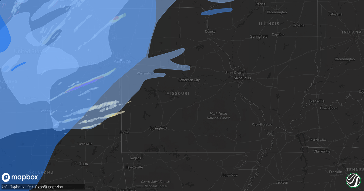
Hail Map in Missouri on December 15, 2021
Get this storm
December 15 map
$229
one time, instant access
Download today. No call, no setup
Keep the $229
Bought the map and want the full workflow? Apply the entire $229 to a subscription within 7 days. None of it is wasted.
Every map, not just this one
This buys you this map. Subscription and you get every map we run, in the markets you choose from a few cities to whole states to nationwide. Plus real-time alerts the moment a storm fires.
Contact data
Name, contact info, occupancy, even credit band for addresses in the footprint. You go from where it hit to who to call.
Become the source they trust
Unlimited branding weather history reports on demand. You already have the documented answer ready for the property owner, and you are the one who showed up with it.
Property data and RoofTrace estimates
Pull up any address you have got, its value and the exact code rules for that jurisdiction, straight from One Click Code. Then RoofTrace estimates the squares, pitch, and roof value, priced the way you price.
Storm reports in Missouri
Missouri
| Date | Description |
|---|---|
| 12/15/20215:17 PM CST | Golf ball sized hail reported on south main street. Power lines and trees down in town. Reported by law enforcement relayed by emergency management. |
| 12/15/20215:17 PM CST | Debris in the roadway and light poles down. Time estimated from radar. |
| 12/15/20215:13 PM CST | Delayed report. A few windows blown out of a home. |
| 12/15/20215:12 PM CST | Damage to outbuildings reported. |
| 12/15/20214:51 PM CST | Trained spotter reported 90 mph winds relayed by law enforcement. |
| 12/15/20214:51 PM CST | Trained spotter reported 90 mph winds relayed by law enforcement. |
| 12/15/20214:48 PM CST | Trained spotter reported 70 mph winds relayed to us by law enforcement. |
| 12/15/20214:37 PM CST | Corrects previous non-tstm wnd gst report from 1 w tarkio. Trained spotter report. |
| 12/15/20214:27 PM CST | Cwsw pella marion ia 4140 9295 peak wind gust from kpea. |
| 12/15/20214:27 PM CST | Corrects previous non-tstm wnd gst report from 2 n watson. |
| 12/15/20211:01 PM CST | Report from mping: 3-inch tree limbs broken; power poles broken. |
| 12/15/20212:53 AM CST | At 853 PM CST, severe thunderstorms were located along a line extending from near Cotter to 9 miles southwest of Wayland, moving east at 50 mph. HAZARD...70 mph wind gusts. SOURCE...Radar indicated. IMPACT...Expect considerable tree damage. Damage is likely to mobile homes, roofs, and outbuildings. Locations impacted include... Burlington, Fort Madison, Keokuk, Carthage, Oquawka, Nauvoo, West Burlington, Hamilton, Warsaw, Mediapolis, La Harpe, Dallas City, Danville, Stronghurst, Bowen, Middletown, Carman, Gladstone, Terre Haute and West Point. |
| 12/15/20212:34 AM CST | At 833 PM CST, severe thunderstorms were located along a line extending from near Kinross to Memphis, moving northeast at 55 mph. HAZARD...70 mph wind gusts. SOURCE...Radar indicated. IMPACT...Expect considerable tree damage. Damage is likely to mobile homes, roofs, and outbuildings. Severe thunderstorms will be near... Kinross around 840 PM CST. |
| 12/15/20212:34 AM CST | At 834 PM CST, severe thunderstorms were located along a line extending from near Higbee to near Tipton, moving east at 55 mph. HAZARD...60 mph wind gusts. SOURCE...Radar indicated. IMPACT...Expect damage to roofs, siding, and trees. Severe thunderstorms will be near... Madison around 850 PM CST.Other locations in the path of these severe thunderstorms includeJamestown, Paris, Easley, Ashland and Columbia Regional Airport.This includes Interstate 70 in Missouri between exits 115 and 148. This also includes Rock Bridge State Park, Finger Lakes State Park,Union Covered Bridge Historic Site, Jewell Cemetery Historic Site,and Mark Twain Lake Recreational Area. |
| 12/15/20212:25 AM CST | At 825 PM CST, severe thunderstorms were located along a line extending from near Huntsville to near Fayette to near Pilot Grove to near Otterville, moving northeast at 80 mph. HAZARD...60 mph wind gusts. SOURCE...Radar indicated. IMPACT...Expect damage to roofs, siding, and trees. Locations impacted include... Moberly, Boonville, Fayette, Huntsville, New Franklin, Pilot Grove, Higbee, Otterville, Bunceton, Clark, Cairo, Armstrong, Prairie Home, Renick, Jacksonville, Franklin, Wooldridge and Lamine.This includes Interstate 70 in Missouri between mile markers 94 and114. |
| 12/15/20211:42 AM CST | At 742 PM CST, severe thunderstorms were located along a line extending from 11 miles southwest of Appleton City to Schell City to near Walker, moving northeast at 65 mph. HAZARD...60 mph wind gusts. SOURCE...Radar indicated. IMPACT...Expect damage to roofs, siding, and trees. Locations impacted include... Truman Lake... Appleton City... Osceola... Lowry City... Roscoe... Tiffin... Johnson City... Taberville... Iconium... Monegaw Springs... |
| 12/15/20211:31 AM CST | At 730 PM CST, severe thunderstorms were located along a line extending from near Oskaloosa to 11 miles southeast of Centerville, moving east at 40 mph. HAZARD...70 mph wind gusts and penny size hail. SOURCE...Radar indicated. IMPACT...Expect considerable tree damage. Damage is likely to mobile homes, roofs, and outbuildings. Locations impacted include... Fairfield, Sigourney, Memphis, Keosauqua, Hedrick, What Cheer, Richland, Batavia, Birmingham, Milton, Delta, Libertyville, Maharishi Vedic City, Keswick, Cantril, South English, Packwood, Harper, Martinsburg and Rutledge. |
| 12/15/20211:09 AM CST | At 708 PM CST, severe thunderstorms were located along a line extending from near Grinnell to 11 miles west of Unionville, moving east at 65 mph. HAZARD...70 mph wind gusts. SOURCE...Radar indicated. IMPACT...Expect considerable tree damage. Damage is likely to mobile homes, roofs, and outbuildings. Locations impacted include... Ottumwa, Oskaloosa, Pella, Grinnell, Knoxville, Centerville, Albia, Bloomfield, Montezuma, Brooklyn, New Sharon, Eddyville, Ottumwa Industrial Airport, Rock Creek Lake, Lake Sundown, Rathbun Lake, Lake Red Rock, Eldon, Victor and Sully.This includes Interstate 80 between mile markers 170 and 204. |
| 12/15/20211:08 AM CST | At 707 PM CST, severe thunderstorms were located along a line extending from near Fulton to near Redfield to near Galesburg, moving east at 60 mph. HAZARD...60 mph wind gusts and penny size hail. SOURCE...Radar indicated. IMPACT...Expect damage to roofs, siding, and trees. Locations impacted include... Pittsburg... Prairie State Park... Nevada... Fort Scott... Lamar... Frontenac... Girard... Arma... Marmaton... Liberal... Sheldon... Mulberry... Mindenmines... Franklin... Montevallo... Arcadia... Walker... Schell City... Bronaugh... Walnut... This includes Interstate 49 between mile markers 66 and 107. |
| 12/15/20211:08 AM CST | At 707 PM CST, severe thunderstorms were located along a line extending from near Wellington to near Kingsville to near Rich Hill, moving northeast at 80 mph. HAZARD...70 mph wind gusts. SOURCE...Radar indicated. IMPACT...Expect considerable tree damage. Damage is likely to mobile homes, roofs, and outbuildings. Locations impacted include... Sedalia, Warrensburg, Marshall, Clinton, Boonville, Odessa, Higginsville, Lexington, Butler, Windsor, Knob Noster, Fayette, Concordia, Holden, Slater, Garden City, Sweet Springs, Rich Hill, Glasgow and Whiteman Air Force Base.This includes Interstate 70 in Missouri between mile markers 35 and115. |
| 12/15/202112:43 AM CST | At 642 PM CST, severe thunderstorms were located along a line extending from Lee's Summit to Raymore to near Drexel, moving northeast at 80 mph. HAZARD...70 mph wind gusts. SOURCE...Radar indicated. IMPACT...Expect considerable tree damage. Damage is likely to mobile homes, roofs, and outbuildings. Locations impacted include... Lee's Summit, Belton, Raymore, Warrensburg, Harrisonville, Pleasant Hill, Greenwood, Peculiar, Knob Noster, Holden, Lake Lotawana, Garden City, Whiteman Air Force Base, Lake Winnebago, Lone Jack, Leeton, Freeman, Chilhowee, East Lynne and Kingsville. |
| 12/15/202112:35 AM CST | At 634 PM CST, a severe thunderstorm was located over Levasy, or near Buckner, moving east at 65 mph. HAZARD...70 mph wind gusts. SOURCE...Radar indicated. IMPACT...Expect considerable tree damage. Damage is likely to mobile homes, roofs, and outbuildings. Locations impacted include... Independence, Blue Springs, Grain Valley, Oak Grove, Odessa, Higginsville, Lexington, Buckner, Concordia, Lake Lotawana, Waverly, Wellington, Corder, Alma, Sibley, Blackburn, Mayview, Levasy, Lake Lafayette and Emma.This includes Interstate 70 in Missouri between mile markers 20 and62. |
| 12/15/202112:16 AM CST | At 615 PM CST, a severe thunderstorm was located over Humboldt, moving east at 65 mph. HAZARD...60 mph wind gusts and quarter size hail. SOURCE...Radar indicated. IMPACT...Hail damage to vehicles is expected. Expect wind damage to roofs, siding, and trees. Locations impacted include... Nevada... Fort Scott... Marmaton... Bronson... Uniontown... Walker... Bronaugh... Fulton... Redfield... Moundville... Richards... Milo... Mapleton... Deerfield... Metz... Stotesbury... Harding... Petersburg... Porterville... Xenia... This includes Interstate 49 between mile markers 79 and 107. |
| 12/15/202112:11 AM CST | At 610 PM CST, severe thunderstorms were located along a line extending from near Osawatomie to near Kincaid to Humboldt, moving east at 60 mph. HAZARD...70 mph wind gusts. SOURCE...Radar indicated. IMPACT...Expect considerable tree damage. Damage is likely to mobile homes, roofs, and outbuildings. Locations impacted include... Lee's Summit, Grandview, Belton, Raymore, Harrisonville, Pleasant Hill, Paola, Spring Hill, Greenwood, Peculiar, Osawatomie, Louisburg, Butler, Adrian, Garden City, Rich Hill, Pleasanton, La Cygne, Mound City and Archie. |
| 12/15/202112:00 AM CST | At 559 PM CST, a severe thunderstorm was located near Olathe, moving east at 60 mph. HAZARD...Two inch hail and 70 mph wind gusts. SOURCE...Trained weather spotters. IMPACT...People and animals outdoors will be injured. Expect hail damage to roofs, siding, windows, and vehicles. Expect considerable tree damage. Wind damage is also likely to mobile homes, roofs, and outbuildings. Locations impacted include... Kansas City, Overland Park, Olathe, Independence, Lee's Summit, Shawnee, Blue Springs, Lenexa, Leawood, Raytown, Grandview, Belton, Prairie Village, Raymore, Gardner, Grain Valley, Merriam, Mission, Pleasant Hill and Spring Hill.This includes the following highways... Interstate 70 in Missouri between mile markers 1 and 29. Interstate 35 in Missouri between mile markers 0 and 4. Interstate 35 in Kansas between mile markers 211 and 235. Interstate 635 between mile markers 0 and 2. Interstate 470 between mile markers 0 and 16. Interstate 435 between mile markers 0 and 8, and between milemarkers 57 and 83. |
| 12/14/202111:31 PM CST | At 531 PM CST, a severe thunderstorm was located near Ottawa, moving northeast at 70 mph. HAZARD...70 mph wind gusts and ping pong ball size hail. SOURCE...Trained weather spotters. IMPACT...People and animals outdoors will be injured. Expect hail damage to roofs, siding, windows, and vehicles. Expect considerable tree damage. Wind damage is also likely to mobile homes, roofs, and outbuildings. Locations impacted include... Overland Park, Olathe, Shawnee, Lenexa, Leawood, Prairie Village, Gardner, Merriam, Mission, Bonner Springs, De Soto, Paola, Spring Hill, Edwardsville, Louisburg, Fairway, Mission Hills, Edgerton, Westwood and Lake Quivira.This includes the following highways... Interstate 35 in Kansas between mile markers 200 and 230. Interstate 635 near mile marker 0. Interstate 435 between mile markers 0 and 7, and between milemarkers 76 and 83. |
| 12/14/202111:22 PM CST | At 522 PM CST, severe thunderstorms were located along a line extending from near Lake Icaria to 6 miles northwest of Ravenwood, moving northeast at 85 mph. HAZARD...70 mph wind gusts. SOURCE...Radar indicated. IMPACT...Expect considerable tree damage. Damage is likely to mobile homes, roofs, and outbuildings. Locations impacted include... Mount Ayr and Leon.This includes Interstate 35 between mile markers 1 and 44. |
| 12/14/202111:18 PM CST | At 518 PM CST, a severe thunderstorm was located near Oskaloosa, moving northeast at 75 mph. HAZARD...70 mph wind gusts. SOURCE...Radar indicated. IMPACT...Expect considerable tree damage. Damage is likely to mobile homes, roofs, and outbuildings. Locations impacted include... Shawnee, Leavenworth, Liberty, Gladstone, Lansing, Excelsior Springs, Cameron, Smithville, Kearney, Bonner Springs, Parkville, Tonganoxie, Platte City, Basehor, Edwardsville, North Kansas City, Riverside, Lawson, Plattsburg and Lathrop.This includes the following highways... Interstate 70 in Missouri near mile marker 0. Interstate 70 in Kansas between mile markers 410 and 423. Interstate 35 in Missouri between mile markers 6 and 55. Interstate 35 in Kansas between mile markers 232 and 234. Interstate 29 between mile markers 0 and 30. Interstate 635 between mile markers 1 and 12. Interstate 435 between mile markers 9 and 55. Kansas Turnpike between mile markers 206 and 226. |
| 12/14/202110:13 PM CST | At 412 PM CST, severe thunderstorms were located along a line extending from near Pisgah to near Hamburg, moving northeast at 70 mph. THESE ARE DESTRUCTIVE STORMS FOR SOUTHWEST IOWA! HAZARD...80 mph wind gusts. SOURCE...Radar indicated. IMPACT...Flying debris will be dangerous to those caught without shelter. Mobile homes will be heavily damaged. Expect considerable damage to roofs, windows, and vehicles. Extensive tree damage and power outages are likely. Locations impacted include... Corning and Lenox.This includes Interstate 80 between mile markers 50 and 82. |
| 12/14/20219:55 PM CST | At 354 PM CST, severe thunderstorms were located along a line extending from near Waterloo to 5 miles northeast of Summerfield, moving east at 75 mph. THESE ARE DESTRUCTIVE STORMS. HAZARD...90 mph wind gusts. SOURCE...Trained weather spotters. IMPACT...You are in a life-threatening situation. Flying debris may be deadly to those caught without shelter. Mobile homes will be heavily damaged or destroyed. Homes and businesses will have substantial roof and window damage. Expect extensive tree damage and power outages. Locations impacted include... Shelby, Minden, Avoca and Walnut.This includes Interstate 80 in Iowa between mile markers 29 and 48. |
| 12/14/20219:06 PM CST | Tree was blown over onto roadway at intersection of highway ww and s. Rangeline road. |
| 12/14/20219:00 PM CST | Street light snapped and blocking roadway at 7th and cherry. |
| 12/14/20218:59 PM CST | Several trees blown down across old plank road near intersection with route k. The trees are over a foot in diameter. |
| 12/14/20218:59 PM CST | Power lines down at providence and wilkes. |
| 12/14/20218:53 PM CST | Ten inch diameter tree blown over onto old highway 63 near dripping springs road. |
| 12/14/20218:44 PM CST | Tree blown down onto route f at intersection with stidham road. |
| 12/14/20218:41 PM CST | 1.5 foot diameter tree blown down. |
| 12/14/20218:35 PM CST | Kmby. |
| 12/14/20218:09 PM CST | A local report indicates 58 MPH wind near SEDALIA MEMORIAL ARPT |
| 12/14/20218:09 PM CST | Corrects previous tstm wnd gst report from sedalia memorial arpt. |
| 12/14/20217:30 PM CST | Most of the roof to an automotive repair facility was blown off. Time estimated from radar. |
| 12/14/20217:24 PM CST | Estimated 75 to 80 mph winds reported as storms moved through unionville. |
| 12/14/20217:17 PM CST | A local report indicates 60 MPH wind near 3 W CENTERVIEW |
| 12/14/20217:06 PM CST | State troopers car pushed off the road. Time estimated based on radar. |
| 12/14/20216:55 PM CST | Several trees down in southeast trenton. |
| 12/14/20216:53 PM CST | Estimated wind gust at nws kansas city. |
| 12/14/20216:46 PM CST | Numerous trees... Power lines... And signs blown down in trenton. Part of roof blown off in downtown. |
| 12/14/20216:45 PM CST | A local report indicates 60 MPH wind near 1 NW LAKE WINNEBAGO |
| 12/14/20216:39 PM CST | A local report indicates 60 MPH wind near 2 S BRIMSON |
| 12/14/20216:29 PM CST | Multiple windows blown out and shingles removed from roof. Two 6 to 8 inch diameter trees blown down. |
| 12/14/20216:23 PM CST | Report of power poles down in bethany. Time estimated via radar. |
| 12/14/20216:20 PM CST | Large tree down blocking highway 116 west of plattsburg. |
| 12/14/20216:19 PM CST | Report of carport and lean to blown over. |
| 12/14/20216:10 PM CST | A local report indicates 1.00 inch wind near LAKE WAUKOMIS |
| 12/14/20216:09 PM CST | A local report indicates 77 MPH wind near KANSAS CITY DOWNTOWN AI |
| 12/14/20216:09 PM CST | Video of roof ripping off hanger at kmkc. Asos measured wind gust of 77 mph. |
| 12/14/20216:06 PM CST | Report of people trapped in a cellar with house collapsed on top. Law enforcement and fire department responding. |
| 12/14/20216:06 PM CST | Power lines down near nw 56th st and interstate 29. Time estimated via radar. |
| 12/14/20216:00 PM CST | Several power poles down and an estimated 2500 people out of power. |
All States Impacted by Hail Map on December 15, 2021
Cities Impacted by Hail Map on December 15, 2021
- Nowata, OK
- Delaware, OK
- Americus, KS
- Emporia, KS
- Uniontown, KS
- Redfield, KS
- Whitewater, KS
- Newton, KS
- Mapleton, KS
- Fort Scott, KS
- Moran, KS
- Fulton, KS
- Bronson, KS
- Odebolt, IA
- Holmen, WI
- Axtell, KS
- Pawnee City, NE
- Burchard, NE
- Plattsmouth, NE
- Pacific Junction, IA
- Glenwood, IA
- Murray, NE
- Savonburg, KS
- Fall River, KS
- Fredonia, KS
- Toronto, KS
- Saint Edward, NE
- Fullerton, NE
- Belgrade, NE
- Oakland, IA
- Carson, IA
- Onaga, KS
- Ayr, NE
- Hastings, NE
- Avoca, NE
- Weeping Water, NE
- Elmwood, NE
- Neodesha, KS
- Ottawa, KS
- Onalaska, WI
- Burns, KS
- Osceola, NE
- Giltner, NE
- Hordville, NE
- Marquette, NE
- Stromsburg, NE
- Phillips, NE
- Polk, NE
- Aurora, NE
- Doniphan, NE
- Silver Creek, NE
- Clarks, NE
- Ogden, IA
- Milford, NE
- Dorchester, NE
- Winfield, KS
- Stark, KS
- Prague, NE
- Bruno, NE
- Springfield, NE
- Eagle, NE
- Gretna, NE
- Papillion, NE
- Murdock, NE
- Omaha, NE
- Louisville, NE
- Alvo, NE
- Ashland, NE
- Elk City, KS
- Olpe, KS
- Strong City, KS
- Greenwood, NE
- Pleasant Dale, NE
- Lincoln, NE
- Friend, NE
- Leigh, NE
- Monroe, NE
- Duncan, NE
- Hampton, NE
- Trumbull, NE
- Clarkson, NE
- Shelby, NE
- Columbus, NE
- Arcadia, KS
- Walnut, KS
- Bronaugh, MO
- Erie, KS
- Saint Paul, KS
- Farlington, KS
- Girard, KS
- Liberal, MO
- Hepler, KS
- Morrowville, KS
- Clifton, KS
- Mound City, MO
- Skidmore, MO
- Barnard, MO
- Ravenwood, MO
- Maryville, MO
- Graham, MO
- Maitland, MO
- Clyde, MO
- Conception Junction, MO
- Pierson, IA
- Bronson, IA
- Hornick, IA
- Climbing Hill, IA
- Sloan, IA
- Correctionville, IA
- Kingsley, IA
- Moville, IA
- Anthon, IA
- Salix, IA
- Jefferson, IA
- Augusta, KS
- Bartlesville, OK
- Nehawka, NE
- Carroll, IA
- Scranton, IA
- Cambridge, KS
- Latham, KS
- Burden, KS
- Atlanta, KS
- Trempealeau, WI
- Galesville, WI
- Dakota, MN
- Roseland, NE
- Bladen, NE
- Linn, KS
- Agenda, KS
- Concordia, KS
- Washington, KS
- Clyde, KS
- Hollenberg, KS
- Haddam, KS
- Missouri Valley, IA
- Humboldt, KS
- La Harpe, KS
- Iola, KS
- Yates Center, KS
- Coon Rapids, IA
- Exira, IA
- Hamlin, IA
- Syracuse, NE
- Vassar, KS
- Neosho Rapids, KS
- Lebo, KS
- New Century, KS
- Pomona, KS
- Quenemo, KS
- Wellsville, KS
- Gardner, KS
- Eudora, KS
- Cedar Point, KS
- Lyndon, KS
- Osage City, KS
- Edgerton, KS
- Reading, KS
- Olathe, KS
- Melvern, KS
- Cottonwood Falls, KS
- Baldwin City, KS
- Bennet, NE
- Nebraska City, NE
- Macedonia, IA
- Marne, IA
- Union, NE
- Hancock, IA
- Hastings, IA
- Treynor, IA
- Brayton, IA
- Silver City, IA
- Unadilla, NE
- Council Bluffs, IA
- Mineola, IA
- Offutt Afb, NE
- Dunbar, NE
- Walnut, IA
- Elk Horn, IA
- Bellevue, NE
- Guthrie Center, IA
- Malvern, IA
- Palmyra, NE
- Otoe, NE
- Henderson, IA
- Audubon, IA
- Atlantic, IA
- Bayard, IA
- Edgar, NE
- Williams, IA
- Blairsburg, IA
- David City, NE
- Richards, MO
- Ithaca, NE
- Lincolnville, KS
- Madison, KS
- Palmer, NE
- Essex, IA
- Buffalo, KS
- Fort Calhoun, NE
- Iowa Falls, IA
- Popejoy, IA
- Dows, IA
- Alden, IA
- Hampton, IA
- Filley, NE
- Beatrice, NE
- Blue Springs, NE
- Steele City, NE
- Fairbury, NE
- Belleville, KS
- Odell, NE
- Cuba, KS
- Diller, NE
- Hanover, KS
- Wymore, NE
- Endicott, NE
- Mahaska, KS
- Hooper, NE
- Cedar Bluffs, NE
- Ames, NE
- Fremont, NE
- Onawa, IA
- Whiting, IA
- Decatur, NE
- Macy, NE
- Thayer, KS
- Arma, KS
- Galesburg, KS
- Piedmont, KS
- Severy, KS
- Washta, IA
- Quimby, IA
- Ettrick, WI
- Winona, MN
- La Crescent, MN
- Brainard, NE
- Boone, IA
- Stratford, IA
- Pilot Mound, IA
- Schuyler, NE
- Howard, KS
- Grenola, KS
- Longton, KS
- Moline, KS
- Rock, KS
- Juniata, NE
- Holton, KS
- Waverly, KS
- Dexter, KS
- Burlington, KS
- Hartford, KS
- Talmage, NE
- Powhattan, KS
- Hiawatha, KS
- Salina, KS
- Assaria, KS
- Gypsum, KS
- Solomon, KS
- Chanute, KS
- Bellwood, NE
- Rising City, NE
- Cherryvale, KS
- Dennis, KS
- Parsons, KS
- Havana, KS
- Sedan, KS
- Independence, KS
- Elk Falls, KS
- West Point, NE
- Garnett, KS
- Williamsburg, KS
- White Cloud, KS
- Craig, MO
- Dodge, NE
- Greene, IA
- Charles City, IA
- Marble Rock, IA
- Bristow, IA
- Palmer, KS
- Waverly, NE
- Ceresco, NE
- Bancroft, NE
- Parnell, MO
- Sheridan, MO
- Stanberry, MO
- Walker, MO
- Nevada, MO
- Fort Leavenworth, KS
- Gridley, KS
- Vinita, OK
- Clay Center, KS
- Morganville, KS
- Miltonvale, KS
- Wetmore, KS
- Netawaka, KS
- Grand Island, NE
- Howells, NE
- Saint Paul, NE
- Elsmore, KS
- Scribner, NE
- Havensville, KS
- Admire, KS
- Summerfield, KS
- Nemaha, NE
- Brownville, NE
- Baileyville, KS
- Humboldt, NE
- Table Rock, NE
- Auburn, NE
- Raymond, NE
- Leon, KS
- Aredale, IA
- Rose Hill, KS
- Tobias, NE
- Rogers, NE
- Burr, NE
- Douglas, NE
- Martell, NE
- Crete, NE
- Rodney, IA
- Smithland, IA
- Barnsdall, OK
- Ochelata, OK
- Chapman, NE
- Malcolm, NE
- Davey, NE
- Firth, NE
- Panama, NE
- Hickman, NE
- Adams, NE
- Pickrell, NE
- Panora, IA
- Bagley, IA
- Yale, IA
- Jamaica, IA
- Central City, NE
- Dayton, IA
- Wisner, NE
- Beemer, NE
- Sergeant Bluff, IA
- Goff, KS
- Bennington, NE
- Waterloo, NE
- Elkhorn, NE
- Benedict, NE
- Barnes, KS
- Greenleaf, KS
- Mead, NE
- Yutan, NE
- Stanhope, IA
- Boxholm, IA
- Paton, IA
- York, NE
- Hubbell, NE
- Munden, KS
- Narka, KS
- Melrose, WI
- Derby, KS
- Andover, KS
- Wichita, KS
- Virginia, NE
- Crab Orchard, NE
- Linwood, NE
- Sterling, NE
- Roca, NE
- Horton, KS
- Robinson, KS
- Bolckow, MO
- Forest City, MO
- Oregon, MO
- Grand Junction, IA
- Dana, IA
- Rippey, IA
- North Bend, NE
- Morse Bluff, NE
- Manley, NE
- Charter Oak, IA
- Grimes, IA
- Verdigre, NE
- Milton, KS
- Surprise, NE
- Bondurant, IA
- Counselor, NM
- Pemberton, MN
- Wallingford, IA
- Randall, KS
- Pritchett, CO
- Center, CO
- Vernon Center, MN
- Offerle, KS
- Oberlin, KS
- Branson, CO
- Downs, KS
- Wilsey, KS
- Maybell, CO
- Happy, TX
- Halbur, IA
- Durango, CO
- Barnum, IA
- White River, SD
- Fort Garland, CO
- Tierra Amarilla, NM
- Pierre, SD
- Fulton, SD
- San Jon, NM
- Weldon, IA
- White Owl, SD
- Thoreau, NM
- Danville, KS
- Wentworth, SD
- Bristow, NE
- Rainsville, NM
- Minneota, MN
- Amalia, NM
- Malmo, NE
- Cunningham, KS
- Soldier, IA
- Cimarron, KS
- Hillsboro, KS
- Revere, MN
- Lineville, IA
- Rosalia, KS
- Casa Blanca, NM
- Tabor, IA
- Idaho Springs, CO
- Magnet, NE
- Harveyville, KS
- Box Elder, SD
- Merna, NE
- Calumet, IA
- Presho, SD
- Scotia, NE
- Albin, WY
- Lost Springs, WY
- Meservey, IA
- Haysville, KS
- Storden, MN
- Breckenridge, MO
- Childress, TX
- Independence, MO
- Canjilon, NM
- Springlake, TX
- Swink, CO
- Drummond, OK
- Placitas, NM
- Lyman, NE
- Jamestown, KS
- Solano, NM
- Oakdale, NE
- Pisgah, IA
- Pratt, KS
- Fairview, KS
- Platte, SD
- Missouri City, MO
- Webster, MN
- Coaldale, CO
- Burlington, CO
- Rockwell, IA
- Truesdale, IA
- Leavenworth, KS
- Cherokee, IA
- Plankinton, SD
- Bryant, SD
- Naponee, NE
- Laurens, IA
- Bruce, SD
- Turon, KS
- Warner, SD
- Martensdale, IA
- Bogue, KS
- Alva, OK
- Arnolds Park, IA
- Cologne, MN
- Pukwana, SD
- Hobbs, NM
- Corning, IA
- Pueblo, CO
- Grant City, MO
- Lake View, IA
- Hardy, IA
- Morland, KS
- Dexter, IA
- Cedaredge, CO
- Oklahoma City, OK
- Glencoe, MN
- Yampa, CO
- Effingham, KS
- Dolliver, IA
- Longford, KS
- Vaughn, NM
- Logan, IA
- Vega, TX
- Wiggins, CO
- Lodgepole, SD
- Orchard, CO
- Blooming Prairie, MN
- Halstead, KS
- Northville, SD
- Chester, OK
- Olney Springs, CO
- Mapleton, IA
- McCracken, KS
- Vinson, OK
- Matador, TX
- Flagler, CO
- Allenspark, CO
- Taloga, OK
- Kenyon, MN
- Hospers, IA
- Watertown, SD
- Colton, SD
- Bloomfield, NM
- Fort Sumner, NM
- Jamestown, NM
- Clinton, MN
- Hanston, KS
- Wilmore, KS
- Okarche, OK
- Coin, IA
- Odessa, MN
- Madison, MN
- Alcester, SD
- Buena Vista, NM
- Lonsdale, MN
- Steen, MN
- Guernsey, WY
- Kensington, KS
- Bethune, CO
- Martin, SD
- Harrisburg, SD
- Allerton, IA
- Emmet, NE
- Colon, NE
- Mitchell, NE
- Dulce, NM
- Enders, NE
- Wayne, NE
- Central City, CO
- North Loup, NE
- Roxbury, KS
- Lorimor, IA
- Milbank, SD
- Blockton, IA
- Rockham, SD
- Nekoma, KS
- Weston, NE
- Lockney, TX
- Rexford, KS
- Herndon, KS
- Elysian, MN
- Kersey, CO
- Guymon, OK
- Molina, CO
- Claflin, KS
- Satanta, KS
- Gilbert, IA
- Hills, MN
- Granada, MN
- Gibbon, NE
- Lewisville, MN
- Owanka, SD
- Artesian, SD
- Beaver, OK
- Clay Center, NE
- Clearwater, KS
- Carpenter, WY
- Idledale, CO
- Goodwin, SD
- Fort Pierre, SD
- Manly, IA
- Edgerton, MO
- Dearborn, MO
- Simpson, KS
- Jewell, IA
- Dunnell, MN
- Hitchcock, SD
- Murray, IA
- Quanah, TX
- Darfur, MN
- Quitaque, TX
- Rociada, NM
- Gateway, CO
- Miller, SD
- Poncha Springs, CO
- Marion, SD
- Warsaw, MN
- Blackwell, OK
- Atlanta, NE
- Mora, NM
- Nunn, CO
- Vivian, SD
- Fairburn, SD
- Ringwood, OK
- Byers, KS
- Blencoe, IA
- Booneville, IA
- Enning, SD
- Wallace, NE
- Spencer, IA
- Hugoton, KS
- Palco, KS
- Mercer, MO
- Oneida, KS
- Omega, OK
- Superior, NE
- Waubay, SD
- Vona, CO
- Mount Hope, KS
- Newman Grove, NE
- Memphis, TX
- Dresden, KS
- Lu Verne, IA
- Mason City, NE
- Latimer, IA
- Valmora, NM
- Denison, KS
- De Witt, NE
- Ness City, KS
- Steinauer, NE
- Morgan, MN
- Silver Lake, KS
- Titonka, IA
- Wolfforth, TX
- Nicollet, MN
- Delphos, KS
- Parmelee, SD
- South Haven, KS
- Crookston, NE
- Farley, MO
- Phippsburg, CO
- Parlin, CO
- Alta, IA
- Peru, IA
- Wildorado, TX
- Hershey, NE
- Eagle Grove, IA
- Edgemont, SD
- Romeo, CO
- Boncarbo, CO
- Oldham, SD
- Chillicothe, MO
- Empire, CO
- Freeman, SD
- Scranton, KS
- Granville, IA
- Ridgway, CO
- Chester, SD
- Fonda, IA
- Vadito, NM
- Erick, OK
- Del Norte, CO
- Tatum, NM
- Saint Libory, NE
- Moorland, IA
- Golden, CO
- Rosalie, NE
- Red Feather Lakes, CO
- Winfred, SD
- Ogden, KS
- Thurston, NE
- Binger, OK
- Hinton, IA
- Fordyce, NE
- Orchard, NE
- Deerfield, KS
- Maxwell, NM
- Littleton, CO
- Datil, NM
- Scandia, KS
- Emerson, NE
- Goodland, KS
- Palisade, NE
- Cee Vee, TX
- Osmond, NE
- Wesley, IA
- Mankato, MN
- Ravenna, NE
- Garden Grove, IA
- Oskaloosa, KS
- Foss, OK
- Sheffield, IA
- Lamoni, IA
- Modale, IA
- Holland, MN
- Shubert, NE
- New Underwood, SD
- Maize, KS
- Villisca, IA
- Corydon, IA
- Highland, KS
- Stapleton, NE
- Torreon, NM
- Ellsworth, MN
- Sundown, TX
- Carlsbad, NM
- Minturn, CO
- Ohio City, CO
- Ringsted, IA
- Hardwick, MN
- Bison, OK
- Sanborn, MN
- Lenox, IA
- Parker, KS
- Lakefield, MN
- Western, NE
- Creston, IA
- Canistota, SD
- Oneill, NE
- Frankfort, KS
- Schleswig, IA
- Granite, CO
- Clarksdale, MO
- Encino, NM
- Windsor Heights, IA
- Elbert, CO
- Anton Chico, NM
- Waterbury, NE
- Shambaugh, IA
- Crescent, IA
- Kiowa, KS
- Marienthal, KS
- Westbrook, MN
- Scarville, IA
- Humphrey, NE
- Colony, OK
- Snowmass, CO
- Early, IA
- Weston, MO
- Hagerman, NM
- Canones, NM
- Center, NE
- Interior, SD
- Luther, IA
- San Ysidro, NM
- Sayre, OK
- Sentinel, OK
- Parshall, CO
- Burns, CO
- Crawford, OK
- Gilmore City, IA
- North Sioux City, SD
- Santa Fe, NM
- Canton, OK
- Wamego, KS
- Albany, MO
- Dillon, CO
- Sutherland, IA
- West Des Moines, IA
- Hamilton, KS
- Topeka, KS
- Brookville, KS
- Cedar, KS
- Welda, KS
- Willow Island, NE
- Elsie, NE
- Saint Joseph, MO
- Oelrichs, SD
- Tingley, IA
- Reva, SD
- Fairmont, NE
- Ricketts, IA
- Hartford, SD
- Cheney, KS
- Yoder, WY
- Thurman, IA
- Jackson, NE
- Laramie, WY
- Long Island, KS
- Murdock, KS
- Prairie Village, KS
- Randolph, IA
- Cordova, NM
- Lorraine, KS
- Waseca, MN
- Hollis, OK
- Brownell, KS
- Lebanon, KS
- Burr Oak, KS
- Ashland, KS
- Ireton, IA
- Rozel, KS
- Salem, NE
- Crossroads, NM
- Adrian, TX
- Ottosen, IA
- Bradley, SD
- Johnston, IA
- Imperial, NE
- Basalt, CO
- Dundas, MN
- Callaway, NE
- Ojo Caliente, NM
- Kanopolis, KS
- Oak Grove, MO
- Ellendale, MN
- Peralta, NM
- Peabody, KS
- Clayton, KS
- Beulah, CO
- Sioux Falls, SD
- Berthoud, CO
- Brady, NE
- Evans, CO
- Dow City, IA
- Clatonia, NE
- Garrett, WY
- Lester, IA
- Fairfax, MN
- Albuquerque, NM
- Drake, CO
- Newport, NE
- Pinehill, NM
- Wood Lake, NE
- Fort Morgan, CO
- Fedora, SD
- Gillett Grove, IA
- Lovington, NM
- Mclean, TX
- Duncombe, IA
- Delta, CO
- Blanchard, IA
- Jetmore, KS
- Falun, KS
- Piqua, KS
- Canute, OK
- Harrison, NE
- Lincoln, KS
- Andale, KS
- Hereford, TX
- Lucas, IA
- Clearmont, MO
- Grenville, NM
- Underwood, IA
- Hurley, SD
- Simla, CO
- Du Bois, NE
- Cochiti Pueblo, NM
- Savannah, MO
- Afton, IA
- Darlington, MO
- Portales, NM
- Braddyville, IA
- Oakwood, OK
- Medford, OK
- Bigelow, MN
- San Cristobal, NM
- Bingham Lake, MN
- Oyens, IA
- Cuervo, NM
- De Soto, IA
- La Veta, CO
- Emmons, MN
- Bard, NM
- Waco, NE
- Farragut, IA
- Winterset, IA
- Cook, NE
- Ashton, IA
- Byers, CO
- San Luis, CO
- Volin, SD
- Sheridan Lake, CO
- Deshler, NE
- Knierim, IA
- Aspinwall, IA
- Taiban, NM
- Chappell, NE
- Oxford, NE
- Fostoria, IA
- Pfeifer, KS
- Jordan, MN
- Shawnee, WY
- Bucklin, KS
- Watrous, NM
- Cody, NE
- Bradgate, IA
- Ohkay Owingeh, NM
- Midland, SD
- Kirtland, NM
- Little River, KS
- Windom, KS
- Plains, TX
- Seagraves, TX
- Ree Heights, SD
- Battle Creek, NE
- Trinchera, CO
- Las Vegas, NM
- Lubbock, TX
- Tampa, KS
- Nenzel, NE
- Neola, IA
- Nemo, SD
- Echo, MN
- Canby, MN
- Trenton, MO
- Gresham, NE
- Le Mars, IA
- Panhandle, TX
- Cresbard, SD
- Hanlontown, IA
- Lake City, CO
- Amboy, MN
- Mission, SD
- Cascade, CO
- Stuart, NE
- Harlan, IA
- Hernandez, NM
- Orrick, MO
- Fort Cobb, OK
- Liberal, KS
- Valley Falls, KS
- Logan, KS
- Reliance, SD
- Byron, NE
- Chadron, NE
- Summerfield, TX
- Bovina, TX
- Wolcott, CO
- Belle Plaine, MN
- Otho, IA
- Everly, IA
- Limon, CO
- Chandler, MN
- Seminole, TX
- Tijeras, NM
- Ensign, KS
- Gill, CO
- Torrington, WY
- Shickley, NE
- Pitkin, CO
- Lance Creek, WY
- Mooreland, OK
- Patterson, IA
- Alda, NE
- Hubbard, IA
- Sylvia, KS
- Axtell, NE
- Willow, OK
- Elk Mountain, WY
- Des Moines, IA
- Hugo, CO
- Pleasanton, NE
- Nevada, IA
- Corsica, SD
- Sawyer, KS
- Rapid City, SD
- Lancaster, KS
- Colome, SD
- Cheyenne, OK
- Rush, CO
- Grafton, IA
- Gravity, IA
- Prewitt, NM
- Summit, SD
- Larrabee, IA
- Granada, CO
- Hasty, CO
- Erwin, SD
- Shattuck, OK
- Johnstown, CO
- Cortez, CO
- Protection, KS
- Stilwell, KS
- Holdrege, NE
- Esbon, KS
- Cubero, NM
- Syracuse, KS
- Mcdonald, NM
- Henry, SD
- Shawnee, CO
- Chama, CO
- McDonald, KS
- Freedom, OK
- Rollinsville, CO
- Archer, NE
- Plattsburg, MO
- Hardy, NE
- Forgan, OK
- La Loma, NM
- Coldwater, KS
- Hardin, MO
- Monument, CO
- Hopkins, MO
- El Prado, NM
- Neligh, NE
- Potwin, KS
- Ralls, TX
- Gann Valley, SD
- Hardtner, KS
- Willard, NM
- Wounded Knee, SD
- Union City, OK
- Allen, KS
- Mcalister, NM
- Creighton, NE
- Thor, IA
- Wagner, SD
- Pilger, NE
- Monument, KS
- Lake Arthur, NM
- Colby, KS
- Durham, OK
- Corona, NM
- Benkelman, NE
- Lexington, MO
- Folsom, NM
- Wheatland, WY
- Sutherland, NE
- Rulo, NE
- Potter, NE
- Anita, IA
- Buffalo Center, IA
- Berryton, KS
- Bailey, CO
- Ludell, KS
- Brighton, CO
- Stoneham, CO
- North Newton, KS
- Norwood Young America, MN
- Plainview, TX
- Ayrshire, IA
- Andover, SD
- Mosca, CO
- Wanda, MN
- Maple City, KS
- Ransom, KS
- Edgerton, MN
- College Springs, IA
- Randall, IA
- Garden City, KS
- Kranzburg, SD
- Bellvue, CO
- Dickens, NE
- Pecos, TX
- Ransom Canyon, TX
- Isabel, KS
- Leadville, CO
- Ponderosa, NM
- Lamont, OK
- Burnside, IA
- Delia, KS
- Isleta, NM
- Coleridge, NE
- Lone Jack, MO
- Ansley, NE
- Silverton, TX
- Grain Valley, MO
- Manville, WY
- Madrid, IA
- Garita, NM
- Julian, NE
- Gayville, SD
- Wabasso, MN
- Rolfe, IA
- Catharine, KS
- Linn Grove, IA
- Carr, CO
- Coal Creek, CO
- Winter Park, CO
- Akron, CO
- Holcomb, KS
- Keenesburg, CO
- Rosendale, MO
- Morton, TX
- Mangum, OK
- Hamilton, CO
- Henrietta, MO
- Naper, NE
- Beaumont, KS
- Greenwood, MO
- Agency, MO
- Cleo Springs, OK
- Riverton, NE
- Cotopaxi, CO
- Russell, MN
- Lehigh, IA
- Princeton, KS
- Stinnett, TX
- Lake Benton, MN
- Riley, KS
- San Rafael, NM
- Dodson, TX
- Hanska, MN
- Springfield, SD
- Wanblee, SD
- Hinton, OK
- Towanda, KS
- Blomkest, MN
- Dickens, IA
- Janesville, MN
- Gothenburg, NE
- Walker, KS
- Maple, TX
- Tererro, NM
- Alden, MN
- Clayton, NM
- Minneola, KS
- Cuba, NM
- Elk Creek, NE
- Gregory, SD
- Almena, KS
- Stewart, MN
- Goldfield, IA
- Raymond, KS
- New Prague, MN
- Lenora, KS
- Langford, SD
- Broken Bow, NE
- Camp Crook, SD
- Beresford, SD
- Rosebud, SD
- Turkey, TX
- Inwood, IA
- Shelton, NE
- Orlando, OK
- Medford, MN
- Halsey, NE
- Union Center, SD
- Navajo Dam, NM
- Harvard, NE
- Ellsworth, NE
- Heron Lake, MN
- Quinn, SD
- Fort Laramie, WY
- Camden, MO
- Labolt, SD
- Lennox, SD
- Kirk, CO
- Casey, IA
- Mancos, CO
- Hill City, SD
- Moriarty, NM
- Albert Lea, MN
- Utica, MO
- Hillsdale, WY
- Morrison, OK
- Granger, IA
- Indianola, IA
- Ralph, SD
- Humboldt, SD
- Geneva, MN
- Lamar, CO
- Earlham, IA
- Nash, OK
- Kaw City, OK
- Glen Haven, CO
- New Raymer, CO
- Whitman, NE
- Lakin, KS
- Harcourt, IA
- Elida, NM
- Lamy, NM
- Seward, NE
- Rutland, SD
- Home, KS
- Haswell, CO
- Abernathy, TX
- Ponca, NE
- Masterson, TX
- Geary, OK
- Ainsworth, NE
- Bertrand, NE
- Buckner, MO
- Manilla, IA
- Tahoka, TX
- Inman, NE
- Tracy, MN
- Egnar, CO
- Breda, IA
- Muscotah, KS
- Schaller, IA
- Granite Canon, WY
- Riverton, IA
- Saint Clair, MN
- Wilson, KS
- Merrill, IA
- Marvin, SD
- Milford, IA
- Purdum, NE
- Seibert, CO
- Abbyville, KS
- Courtland, KS
- Taylor, NE
- Macksburg, IA
- Beloit, KS
- Nathrop, CO
- Richfield, KS
- Saratoga, WY
- Wellington, KS
- Milan, KS
- Holman, NM
- Larkspur, CO
- Harris, IA
- Faribault, MN
- Deweese, NE
- Two Buttes, CO
- Floyd, NM
- Saronville, NE
- Manchester, OK
- Tabor, SD
- De Smet, SD
- Rushville, NE
- Clarion, IA
- Kilkenny, MN
- Aguilar, CO
- Porter, MN
- Pep, NM
- Mitchell, SD
- Badger, SD
- New Virginia, IA
- Vallecitos, NM
- Snyder, CO
- Gower, MO
- Mcpherson, KS
- Comfrey, MN
- Dacoma, OK
- Elm Creek, NE
- Farnhamville, IA
- Sutton, NE
- Bison, KS
- Penrose, CO
- Platte City, MO
- Amorita, OK
- Elyria, NE
- Woodland Park, CO
- Lafayette, MN
- McFall, MO
- Dighton, KS
- Jemez Pueblo, NM
- Burrton, KS
- Wood, SD
- Los Alamos, NM
- Greensburg, KS
- Ellsworth Afb, SD
- Macksville, KS
- Kittredge, CO
- Webber, KS
- Ankeny, IA
- Defiance, IA
- Sanford, CO
- Pond Creek, OK
- Indianola, NE
- Taunton, MN
- Eagle Lake, MN
- Garland, NE
- Rutland, IA
- Mcgrew, NE
- Jolley, IA
- Alpena, SD
- Gilead, NE
- Pierpont, SD
- Pena Blanca, NM
- Almont, CO
- Blue Earth, MN
- Aspen, CO
- Geddes, SD
- Waldorf, MN
- Natoma, KS
- Brookings, SD
- Soldier, KS
- La Jara, CO
- Tonkawa, OK
- Bouton, IA
- Bison, SD
- Dolores, CO
- Peetz, CO
- Sumner, NE
- Wakonda, SD
- Billings, OK
- Frederick, CO
- Bosque, NM
- Norway, KS
- Griswold, IA
- Falls City, NE
- Crystal Lake, IA
- Santa Rosa, NM
- Raymore, MO
- La Junta, CO
- Pomeroy, IA
- Fowler, CO
- Eldorado Springs, CO
- Fritch, TX
- Zenda, KS
- Gray, IA
- Martinsville, MO
- Cahone, CO
- Johnson, NE
- Burns, WY
- Atkinson, NE
- Estelline, SD
- Ideal, SD
- Vienna, SD
- Sidney, IA
- Greenfield, OK
- Anton, TX
- Castle Rock, CO
- Lone Tree, CO
- Causey, NM
- Springer, NM
- Worthington, MN
- Lake Preston, SD
- Paullina, IA
- Elba, NE
- Sargent, NE
- Buffalo Lake, MN
- Sidney, NE
- Wellington, CO
- Havelock, IA
- Badger, IA
- Mountain Lake, MN
- Lawrence, KS
- Granite Falls, MN
- Scott City, KS
- Bushnell, NE
- Padroni, CO
- Rosston, OK
- Madison, SD
- Sterling, CO
- San Fidel, NM
- Norton, KS
- Montevideo, MN
- Darrouzett, TX
- Marion, KS
- Canton, SD
- Lewis, KS
- Derby, IA
- Brandon, SD
- Eads, CO
- Hammon, OK
- Leonardville, KS
- Minneapolis, KS
- Bingham, NE
- Harrison, SD
- New Castle, CO
- Tekamah, NE
- Galt, MO
- Dallas Center, IA
- Erie, CO
- Howard, SD
- Canton, KS
- Ohiowa, NE
- Blanco, NM
- Conifer, CO
- Tie Siding, WY
- Bowman, ND
- Abiquiu, NM
- Brentford, SD
- Dodge City, KS
- Enochs, TX
- Gypsum, CO
- Minatare, NE
- Anthony, KS
- Veguita, NM
- Rock Valley, IA
- Swaledale, IA
- Amazonia, MO
- Tarkio, MO
- Coffey, MO
- Cedar Crest, NM
- Lynch, NE
- Lucerne, MO
- Eckert, CO
- Firestone, CO
- Gowrie, IA
- Ordway, CO
- Serafina, NM
- McClave, CO
- Elkhart, IA
- Red Cloud, NE
- Boys Town, NE
- Ruskin, NE
- Bosler, WY
- Magnolia, MN
- Valley Center, KS
- Egan, SD
- Greenwich, KS
- Hope, MN
- Slater, IA
- Arvada, CO
- Basehor, KS
- Linwood, KS
- Russell, KS
- Calumet, OK
- Percival, IA
- Carthage, SD
- Joes, CO
- Oxford, KS
- Tescott, KS
- Onida, SD
- El Rito, NM
- Churdan, IA
- Blair, NE
- Trementina, NM
- Geuda Springs, KS
- Johnson, KS
- Buhler, KS
- Cortland, NE
- Elliott, IA
- Pierce, CO
- Grants, NM
- Lehigh, KS
- Calhan, CO
- Slater, CO
- Deadwood, SD
- Woodburn, IA
- Farmington, NM
- Estherville, IA
- Texola, OK
- Muleshoe, TX
- Gordon, NE
- Liebenthal, KS
- Osceola, IA
- Elko New Market, MN
- Kingston, MO
- Saint Peter, MN
- Lucerne, CO
- Olathe, CO
- Valley, NE
- Ogallala, NE
- Jackson, MN
- Crosbyton, TX
- Chugwater, WY
- Westerville, NE
- Hildreth, NE
- New Market, IA
- Garden City, SD
- Nashville, KS
- Sudan, TX
- Grandview, MO
- Lindsay, NE
- Long Valley, SD
- Miami, TX
- Moorhead, IA
- White Deer, TX
- Lindsborg, KS
- Henderson, MN
- Gladstone, NM
- Costilla, NM
- Douglas, OK
- Formoso, KS
- Grand River, IA
- Sanborn, IA
- Shamrock, TX
- Crescent, OK
- May, OK
- Amarillo, TX
- Hartland, MN
- Mills, NM
- Conde, SD
- Sturgis, SD
- Cherry Creek, SD
- Bremen, KS
- Bloomington, NE
- New Laguna, NM
- Log Lane Village, CO
- Woody Creek, CO
- Ong, NE
- Bridgewater, IA
- Tea, SD
- Saint James, MN
- Oak, NE
- Andrews, TX
- Gilman City, MO
- Polk City, IA
- Lisco, NE
- Republican City, NE
- Turton, SD
- Olivet, SD
- Saint Onge, SD
- Meadow Grove, NE
- Florence, CO
- Thayer, IA
- Camden Point, MO
- Richmond, MO
- Bird City, KS
- Bevington, IA
- Ericson, NE
- Laredo, MO
- Hudson, KS
- Fort Dodge, IA
- Atchison, KS
- Lakota, IA
- Olivia, MN
- Windsor, CO
- Silver Plume, CO
- Fenton, IA
- Corwith, IA
- Watson, MO
- Rake, IA
- Garden Plain, KS
- Cedar Creek, NE
- Kennebec, SD
- Kanawha, IA
- Braymer, MO
- Indian Hills, CO
- Primghar, IA
- Elkhart, KS
- Meriden, WY
- Mooresville, MO
- Kearney, NE
- Waterville, MN
- Dinosaur, CO
- Ridgeway, MO
- Hennessey, OK
- Ulysses, NE
- Camargo, OK
- Elgin, NE
- Thompson, IA
- Earling, IA
- Randolph, NE
- Wood Lake, MN
- Meriden, IA
- Spirit Lake, IA
- Marland, OK
- Niobrara, NE
- Morrison, CO
- Massena, IA
- Evergreen, CO
- Miami, NM
- Lucien, OK
- Gallatin, MO
- Keystone, SD
- Sprague, NE
- Chama, NM
- Tipton, KS
- Wilber, NE
- Haigler, NE
- Viborg, SD
- Pipestone, MN
- Burke, SD
- Encampment, WY
- Bates City, MO
- Kremmling, CO
- Fontanelle, IA
- Virgil, SD
- New Richland, MN
- De Beque, CO
- Ghent, MN
- Follett, TX
- McFarland, KS
- Mulhall, OK
- Imogene, IA
- Wynot, NE
- Cordell, OK
- Waterflow, NM
- Englewood, KS
- Bayfield, CO
- Perryton, TX
- Genoa, NE
- Texhoma, TX
- Hillrose, CO
- Sandia Park, NM
- Denver, CO
- Medanales, NM
- Lanesboro, IA
- Whittemore, IA
- Florissant, CO
- Placerville, CO
- Sedgwick, KS
- Haven, KS
- Galva, KS
- Clive, IA
- Pueblo Of Acoma, NM
- Flandreau, SD
- Tryon, NE
- Brewster, MN
- Arboles, CO
- Edgewood, NM
- Jal, NM
- Twin Lakes, MN
- Sibley, MO
- La Crosse, KS
- Olsburg, KS
- Ewing, NE
- Smithville, MO
- Linden, IA
- Kearney, MO
- Le Center, MN
- Dimmitt, TX
- Plainview, NE
- Overton, NE
- Morrill, KS
- Canon City, CO
- Watonga, OK
- Jasper, MN
- Sapello, NM
- Embudo, NM
- Yorktown, IA
- Crested Butte, CO
- Ute, IA
- Maxwell, NE
- Sioux Rapids, IA
- Chatsworth, IA
- La Madera, NM
- Canova, SD
- Weldona, CO
- Groom, TX
- Plainville, KS
- Dorrance, KS
- House, NM
- Kimball, SD
- Sac City, IA
- Cleveland, NM
- Royal, IA
- Newcastle, NE
- Kingman, KS
- Lodgepole, NE
- Elwood, NE
- Fairfax, SD
- Stockton, KS
- Osborn, MO
- Saint Francis, KS
- Blunt, SD
- Carleton, NE
- Rio Rancho, NM
- Davis, SD
- Lytton, IA
- Glenwood Springs, CO
- Centerville, SD
- Kilgore, NE
- Tribune, KS
- Bendena, KS
- Maysville, MO
- Edson, KS
- Wiley, CO
- Bridgewater, SD
- Harper, KS
- Okreek, SD
- Fairfield, NE
- Seneca, KS
- Eddyville, NE
- Grantville, KS
- Nisland, SD
- Wheat Ridge, CO
- Wray, CO
- Lewiston, NE
- Penasco, NM
- Greenfield, IA
- Belden, NE
- Vici, OK
- Cheyenne Wells, CO
- Hart, TX
- Mallard, IA
- Bogard, MO
- Kiowa, CO
- Borger, TX
- Ludlow, SD
- Jewell, KS
- Ovid, CO
- Belle Plaine, KS
- Frost, MN
- Pine Bluffs, WY
- Athol, KS
- Marsland, NE
- Balko, OK
- Davenport, NE
- Hartley, IA
- Seneca, NE
- Holstein, NE
- Grant, IA
- Healy, KS
- Stella, NE
- Paoli, CO
- Ramona, KS
- Sun City, KS
- McLouth, KS
- Cheyenne, WY
- Brule, NE
- Bruning, NE
- Levant, KS
- Alden, KS
- Palmer, IA
- Curlew, IA
- Grant, CO
- Dwight, KS
- Arnold, NE
- Sedalia, CO
- Valley Springs, SD
- Ashton, NE
- Craig, NE
- New Cambria, KS
- Butterfield, MN
- Hartington, NE
- Louviers, CO
- Kit Carson, CO
- Fort Supply, OK
- Big Springs, NE
- Davis City, IA
- Pickstown, SD
- Clara City, MN
- Saint Marys, KS
- Montrose, CO
- Attica, KS
- White Lake, SD
- Pine, CO
- Clark, SD
- Wolsey, SD
- Kellerton, IA
- Dakota City, IA
- Leawood, KS
- Lorton, NE
- Corning, KS
- Genoa, CO
- Stickney, SD
- Lone Wolf, OK
- Logan, NM
- Merriman, NE
- Durham, KS
- Clearfield, IA
- Albert City, IA
- Graettinger, IA
- Rush Center, KS
- Moffat, CO
- Truman, MN
- Wasta, SD
- Collbran, CO
- Dwight, NE
- Lexington, NE
- Trent, SD
- Alton, IA
- Rock Port, MO
- Deer Creek, OK
- Van Tassell, WY
- Ogallah, KS
- Clearwater, NE
- Burdett, KS
- Partridge, KS
- Laverne, OK
- Ashton, SD
- Dallas, SD
- Danube, MN
- Wayside, TX
- Putnam, OK
- Fairplay, CO
- Ellston, IA
- McClelland, IA
- Douglass, KS
- Wood River, NE
- Granby, CO
- Hoyt, KS
- Boulder, CO
- Cochiti Lake, NM
- Venango, NE
- Winthrop, MN
- Bunker Hill, KS
- Richmond, KS
- Texhoma, OK
- Reading, MN
- Ignacio, CO
- Stratford, TX
- Broadwater, NE
- Cactus, TX
- Renwick, IA
- Ames, IA
- Arcadia, NE
- Oglala, SD
- Lakeside, NE
- Albert, KS
- Spalding, NE
- Redvale, CO
- Powersville, MO
- Pickering, MO
- Aurora, CO
- Dover, OK
- Earth, TX
- Saint Marys, IA
- Jamesport, MO
- Carter Lake, IA
- Dixon, NE
- Stamford, NE
- Bedford, IA
- Perry, IA
- Watkins, CO
- Varina, IA
- Olmitz, KS
- Prairie City, SD
- Dawson, NE
- Twin Brooks, SD
- Boone, CO
- Selden, KS
- Carver, MN
- Perry, OK
- Ramah, CO
- Cosby, MO
- Ormsby, MN
- Sacred Heart, MN
- Maywood, NE
- Newell, SD
- Kismet, KS
- Elk Point, SD
- Hendley, NE
- Arapahoe, CO
- Kasota, MN
- Okoboji, IA
- Sargents, CO
- Bazine, KS
- Rico, CO
- Winchester, KS
- Slaton, TX
- Seneca, SD
- Raton, NM
- Stratton, CO
- Amity, MO
- Grenville, SD
- Beaver Creek, MN
- Osage, WY
- Cavour, SD
- Ribera, NM
- Lucas, KS
- Goodwell, OK
- Matfield Green, KS
- Las Animas, CO
- Oacoma, SD
- Whitewood, SD
- Rocky, OK
- Rifle, CO
- Sharon Springs, KS
- Wauneta, NE
- Wellington, TX
- Appleton, MN
- Paradise, KS
- Roosevelt, OK
- Cambridge, NE
- Keyes, OK
- Bushton, KS
- Blue Springs, MO
- Pie Town, NM
- Monte Vista, CO
- Waldo, KS
- Grand Junction, CO
- La Jara, NM
- Goddard, KS
- Gruver, TX
- New Ulm, MN
- Thornton, IA
- Dannebrog, NE
- Courtland, MN
- Emmetsburg, IA
- Chamberlain, SD
- Henderson, NE
- Polo, MO
- Vermillion, SD
- Alexander, KS
- Swea City, IA
- Gallina, NM
- Brownfield, TX
- West Concord, MN
- Minden, IA
- Okaton, SD
- Northfield, MN
- Danbury, NE
- Renner, SD
- Spearman, TX
- Carroll, NE
- Bassett, NE
- Peru, NE
- Madrid, NE
- Fort Lupton, CO
- Ozawkie, KS
- Gorham, KS
- Milligan, NE
- Crooks, SD
- Huxley, IA
- Arlington, MN
- Nickerson, KS
- Sheldon, IA
- King City, MO
- Beaver Crossing, NE
- Glasco, KS
- Storm Lake, IA
- Thornton, CO
- Dumont, CO
- Model, CO
- Larned, KS
- Dunlap, IA
- Elbing, KS
- Lucan, MN
- Newkirk, OK
- Frisco, CO
- Westfield, IA
- Austin, MN
- Harrisburg, NE
- Melvin, IA
- Tabernash, CO
- Beardsley, MN
- South Fork, CO
- Dedham, IA
- Rock River, WY
- Mansfield, SD
- Delmont, SD
- Easton, MN
- Grafton, NE
- Fowler, KS
- Arlington, SD
- Barneston, NE
- Gaylord, MN
- Gracemont, OK
- Mapleton, MN
- North Platte, NE
- Sparks, NE
- Mead, CO
- Dawson, MN
- Cottonwood, MN
- Atwood, CO
- Dixon, WY
- Morristown, MN
- Englewood, CO
- Boise City, OK
- Cleveland, MO
- Doland, SD
- Gurley, NE
- Nageezi, NM
- Orient, IA
- Bartlett, NE
- Valparaiso, NE
- Agate, CO
- Alcalde, NM
- Avon, CO
- Vermillion, KS
- Grant, NE
- Plains, KS
- Sharpsburg, IA
- Milan, NM
- Kimball, NE
- Burt, IA
- Abie, NE
- Swanton, NE
- Coulter, IA
- Hayes, SD
- Clarks Grove, MN
- Little Sioux, IA
- Amistad, NM
- Wellfleet, NE
- Orange City, IA
- Nunda, SD
- Belpre, KS
- Manzanola, CO
- Spickard, MO
- Royal, NE
- Kyle, SD
- Lake City, SD
- Junction City, KS
- Loomis, NE
- Chula, MO
- Platteville, CO
- Ute Park, NM
- Larchwood, IA
- Huron, SD
- Madison Lake, MN
- Eunice, NM
- Verdon, NE
- Caldwell, KS
- Conception, MO
- Emerson, IA
- Ackworth, IA
- Utica, KS
- Red Cliff, CO
- Hay Springs, NE
- Cambridge, IA
- Holbrook, NE
- Hydro, OK
- Turney, MO
- Parachute, CO
- Dexter, NM
- Mountainair, NM
- Cripple Creek, CO
- Alvord, IA
- Rangely, CO
- Elsmere, NE
- Van Horn, TX
- Rand, CO
- Conchas Dam, NM
- Taos, NM
- Ralston, IA
- Mount Ayr, IA
- Emmett, KS
- Eureka, KS
- Viola, KS
- Chester, NE
- Palisade, CO
- Blue Rapids, KS
- Salida, CO
- Copeland, KS
- Olton, TX
- Orient, SD
- Colorado Springs, CO
- Liberty, MO
- Kaylor, SD
- Groton, SD
- Ida Grove, IA
- Reydon, OK
- Lindrith, NM
- Laurel, NE
- Lagrange, WY
- Salt Flat, TX
- Como, CO
- Astoria, SD
- Custer City, OK
- Grover, CO
- Burbank, SD
- Saint Charles, IA
- Iuka, KS
- Pocahontas, IA
- Peyton, CO
- Timnath, CO
- Boyd, MN
- Beaver City, NE
- Republic, KS
- Espanola, NM
- Blanca, CO
- Ivanhoe, MN
- Paxton, NE
- Stuart, IA
- Broadview, NM
- Woden, IA
- Hartville, WY
- Kirkman, IA
- Carter, OK
- Neal, KS
- Pine Ridge, SD
- Ingalls, KS
- Shallowater, TX
- Danbury, IA
- Portis, KS
- Custer, SD
- Belview, MN
- Arco, MN
- Humeston, IA
- Phillipsburg, KS
- Virgil, KS
- Idalou, TX
- Fleming, CO
- Gaylord, KS
- Paola, KS
- Yukon, OK
- Woodward, IA
- De Soto, KS
- Letcher, SD
- Odessa, MO
- Hardesty, OK
- Fulda, MN
- Enterprise, KS
- Hector, MN
- Loving, NM
- Mankato, KS
- Bluewater, NM
- Kenesaw, NE
- Sioux Center, IA
- Jarales, NM
- Green, KS
- Burdick, KS
- Forest City, IA
- Bradshaw, NE
- Broomfield, CO
- Wallace, KS
- Snyder, NE
- Winside, NE
- Smithfield, NE
- South Sioux City, NE
- Carrier, OK
- Wakita, OK
- Marietta, MN
- Hyannis, NE
- Raymond, SD
- Angel Fire, NM
- Riverdale, NE
- Hermosa, SD
- Burlingame, KS
- Towaoc, CO
- Dumas, TX
- Fort Thompson, SD
- Memphis, NE
- Terril, IA
- Texico, NM
- Abilene, KS
- Watson, MN
- Woodrow, CO
- Claremont, MN
- Kinsley, KS
- Kirtland Afb, NM
- Silt, CO
- Stratton, NE
- Auburn, KS
- Oshkosh, NE
- George, IA
- Piedmont, SD
- Greenville, IA
- Colorado City, CO
- Springfield, MN
- Irwin, IA
- Rogers, NM
- Utica, SD
- Laguna, NM
- Homer, NE
- Milroy, MN
- Farnam, NE
- La Vista, NE
- Waynoka, OK
- Weskan, KS
- Longdale, OK
- Lower Brule, SD
- Monument, NM
- New Holland, SD
- Denver City, TX
- Le Roy, KS
- Covington, OK
- Leoti, KS
- Hutchinson, MN
- Meade, KS
- Easton, MO
- Buford, WY
- Alleman, IA
- Bethany, MO
- Bird Island, MN
- Parkston, SD
- Breckenridge, CO
- Ames, OK
- Strang, NE
- Walsenburg, CO
- Clines Corners, NM
- Denver, MO
- El Dorado, KS
- Conway Springs, KS
- San Acacia, NM
- Cromwell, IA
- Rocky Ford, CO
- Alma, NE
- Westboro, MO
- Spearfish, SD
- Nucla, CO
- Maljamar, NM
- Mayfield, KS
- Craig, CO
- Mclean, NE
- Nazareth, TX
- Bricelyn, MN
- Algona, IA
- Ledyard, IA
- Roslyn, SD
- Gove, KS
- Hudson, CO
- Oto, IA
- Levelland, TX
- Newcastle, WY
- Turpin, OK
- Franktown, CO
- Livermore, CO
- Melbeta, NE
- Fairfax, MO
- Des Moines, NM
- Bancroft, IA
- Wausa, NE
- Alliance, NE
- Florence, SD
- Hebron, NE
- Mullen, NE
- Wakarusa, KS
- Fay, OK
- Winona, KS
- Waterville, KS
- Klemme, IA
- Grand Lake, CO
- Liberty Center, IA
- Staplehurst, NE
- Stewartsville, MO
- Gotebo, OK
- Auburn, IA
- Avondale, CO
- Paonia, CO
- Okabena, MN
- Sisseton, SD
- Goodell, IA
- Manhattan, KS
- Mason City, IA
- Leota, MN
- Walton, KS
- Seaforth, MN
- South Shore, SD
- Garretson, SD
- Spencer, NE
- Walton, NE
- Lake Mills, IA
- San Jose, NM
- Ferney, SD
- Antonito, CO
- Mondamin, IA
- Nodaway, IA
- Sharon, KS
- Little Rock, IA
- Southard, OK
- Park, KS
- Johnstown, NE
- Gering, NE
- Hutchinson, KS
- Silverton, CO
- Tyndall, SD
- Black Hawk, CO
- Correll, MN
- Manderson, SD
- Woodbine, KS
- Bennett, CO
- Britt, IA
- Kimballton, IA
- Yeso, NM
- Cherokee, OK
- Hot Springs, SD
- Portsmouth, IA
- Bern, KS
- Inman, KS
- Allen, SD
- Kiester, MN
- Commerce City, CO
- Valdez, NM
- Iroquois, SD
- Vesta, MN
- Rushville, MO
- Crook, CO
- Kennard, NE
- Kim, CO
- Sterling, KS
- Fruita, CO
- Thedford, NE
- Otis, KS
- Aberdeen, SD
- Mission Hill, SD
- Moscow, KS
- Osborne, KS
- Deer Trail, CO
- Alton, KS
- Stanton, IA
- Shawnee, KS
- Franklin, MN
- Garden City, IA
- Van Meter, IA
- Ceylon, MN
- Superior, IA
- Tulare, SD
- Saint Helena, NE
- Colman, SD
- Paguate, NM
- Matheson, CO
- Campbell, NE
- Lahoma, OK
- Lebanon, SD
- Carbondale, KS
- Aline, OK
- Panama, IA
- Worthing, SD
- Lost Springs, KS
- Cedar Vale, KS
- Story City, IA
- Highmore, SD
- Hazelton, KS
- Sabetha, KS
- Eden, SD
- Ranchos De Taos, NM
- Dunning, NE
- Kansas City, KS
- Wakeeney, KS
- Lismore, MN
- Nederland, CO
- Garden City, MN
- Cannon Afb, NM
- Smithwick, SD
- Hayes Center, NE
- Lacona, IA
- Ruthven, IA
- Pender, NE
- Exeter, NE
- Cleghorn, IA
- Peever, SD
- Somerset, CO
- New Hampton, MO
- Nortonville, KS
- Hope, KS
- Greeley, KS
- Bode, IA
- Greeley, CO
- Buffalo, SD
- Madelia, MN
- Kanorado, KS
- Beaver, IA
- Carpenter, SD
- Primrose, NE
- Belle Fourche, SD
- Glen Elder, KS
- Waldron, KS
- Meriden, KS
- El Reno, OK
- Weston, CO
- Tulia, TX
- Blair, OK
- Toponas, CO
- Clements, MN
- Anton, CO
- Templeton, IA
- Loop, TX
- Wathena, KS
- Ouray, CO
- Fort Meade, SD
- Cylinder, IA
- Glendo, WY
- Victor, CO
- Fort Riley, KS
- Volga, SD
- Gallup, NM
- Geneva, NE
- Fertile, IA
- Niwot, CO
- Lemoyne, NE
- Helena, MO
- Udall, KS
- Glenville, MN
- Redfield, SD
- Ellsworth, IA
- Floydada, TX
- Comstock, NE
- Rye, CO
- Skellytown, TX
- Austin, CO
- Woodston, KS
- Hanley Falls, MN
- Boyden, IA
- Scenic, SD
- Dacono, CO
- Higgins, TX
- Milesville, SD
- Hoisington, KS
- Goessel, KS
- Wolbach, NE
- Centralia, KS
- Beulah, WY
- Prescott, IA
- Le Sueur, MN
- Witten, SD
- Florence, KS
- Lansing, KS
- Magnolia, IA
- Oconto, NE
- New Auburn, MN
- Redwood Falls, MN
- Anadarko, OK
- Saint George, KS
- Arlington, KS
- Milan, MN
- Crowley, CO
- Oak Creek, CO
- Owatonna, MN
- Wahoo, NE
- Harris, MO
- Lane, KS
- Garber, OK
- Trimont, MN
- Pagosa Springs, CO
- Everest, KS
- Hunter, KS
- Lyons, CO
- Coolidge, KS
- Beattie, KS
- Saint Charles, SD
- Hunter, OK
- Manter, KS
- Uehling, NE
- Estancia, NM
- Campo, CO
- Cozad, NE
- Lathrop, MO
- Lookeba, OK
- Odessa, NE
- Lead, SD
- Pawnee Rock, KS
- Palmer Lake, CO
- Daykin, NE
- Chase, KS
- Sundance, WY
- Levasy, MO
- Pierce, NE
- Wellington, MO
- Crofton, NE
- Ropesville, TX
- Decatur, IA
- Elkton, SD
- Sedgwick, CO
- Glade, KS
- Fort Collins, CO
- Bloomfield, NE
- Aurora, KS
- Bennington, KS
- Twin Lakes, CO
- Leland, IA
- Jefferson, CO
- Gary, SD
- Sharon, OK
- Loup City, NE
- Stockholm, SD
- Carlisle, IA
- Council Grove, KS
- South Bend, NE
- Quinter, KS
- Mosquero, NM
- Carrollton, MO
- Hays, KS
- Hotchkiss, CO
- Amelia, NE
- Faith, SD
- Longmont, CO
- Guide Rock, NE
- Okeene, OK
- Alamosa, CO
- Kress, TX
- Divide, CO
- Wall, SD
- Hooper, CO
- Westphalia, KS
- Gilcrest, CO
- Holt, MO
- Wilson, TX
- Windom, MN
- Woodbine, IA
- Haxtun, CO
- Estes Park, CO
- Brunsville, IA
- Aztec, NM
- Amherst, TX
- Hale Center, TX
- Jennings, KS
- Claude, TX
- Regina, NM
- Clio, IA
- Clear Lake, IA
- Oakley, KS
- Mesa, CO
- Telluride, CO
- Talmage, KS
- Saguache, CO
- Maynard, MN
- Jelm, WY
- Sugar City, CO
- Leon, IA
- Powderhorn, CO
- Kelley, IA
- Armstrong, IA
- Edmond, OK
- Springview, NE
- Greeley, NE
- Stephan, SD
- Stillwater, OK
- Adrian, MN
- Maple Hill, KS
- Woolstock, IA
- Tell, TX
- Smith Center, KS
- Castana, IA
- Marathon, IA
- Ulysses, KS
- Hamburg, MN
- Rockwell City, IA
- Cushing, IA
- Continental Divide, NM
- Mullinville, KS
- Rockville, NE
- Oakland, NE
- Cumming, IA
- Parker, CO
- Deloit, IA
- Urbandale, IA
- Crawford, NE
- Archer, IA
- Spearville, KS
- Los Lunas, NM
- Baltic, SD
- Grainfield, KS
- Upland, NE
- Inland, NE
- Nelson, NE
- Creede, CO
- Ortonville, MN
- Cope, CO
- Cashion, OK
- Arthur, IA
- Pampa, TX
- Toronto, SD
- Altamont, MO
- De Kalb, MO
- Pep, TX
- Winner, SD
- Murdo, SD
- Riverside, MO
- Colwich, KS
- Waldron, MO
- McCool Junction, NE
- Union Star, MO
- Avon, SD
- Clovis, NM
- Steamboat Springs, CO
- Belvue, KS
- Wilcox, NE
- Buffalo Gap, SD
- Aurelia, IA
- Hedley, TX
- Cummings, KS
- Faulkton, SD
- Goltry, OK
- Creston, NE
- Bonesteel, SD
- Tokio, TX
- Canyon, TX
- Sleepy Eye, MN
- Lawson, MO
- Chimayo, NM
- Allen, NE
- Cawker City, KS
- Spivey, KS
- Wagon Mound, NM
- Geneseo, KS
- Springfield, CO
- White, SD
- Texline, TX
- Liberty, NE
- Rossville, KS
- Lyle, MN
- Waukee, IA
- Damar, KS
- Otis, CO
- Holyrood, KS
- Agra, KS
- Blue Hill, NE
- Marysville, KS
- Lecompton, KS
- Wall Lake, IA
- St John, KS
- Jamestown, CO
- Newkirk, NM
- Elmore, MN
- Castlewood, SD
- Perry, KS
- Ord, NE
- Hill City, KS
- Peculiar, MO
- Cassoday, KS
- Round Lake, MN
- Hesston, KS
- Clarendon, TX
- Dupree, SD
- Cerrillos, NM
- Ellsworth, KS
- Ocheyedan, IA
- Rea, MO
- Hitchcock, OK
- White Rock, NM
- Lyons, NE
- Hazel, SD
- Chambers, NE
- Willow Lake, SD
- Arriba, CO
- Luray, KS
- Holabird, SD
- Gould, OK
- Winnetoon, NE
- Monroe, SD
- Battle Creek, IA
- Altoona, IA
- Holly, CO
- Worth, MO
- Usaf Academy, CO
- Westminster, CO
- Nerstrand, MN
- Red Oak, IA
- Hamburg, IA
- Milnesand, NM
- Avoca, IA
- Winslow, NE
- Milliken, CO
- Beverly, KS
- Hayti, SD
- Petersburg, NE
- Persia, IA
- Franklin, NE
- Crestone, CO
- Winnebago, MN
- Buffalo Creek, CO
- Lusk, WY
- Stafford, KS
- Tyrone, OK
- Tuthill, SD
- Wessington, SD
- Belvidere, NE
- Ford, KS
- Eustis, NE
- Callender, IA
- Platte Center, NE
- Plato, MN
- Wilmont, MN
- Kendall, KS
- Vilas, CO
- Walnut Grove, MN
- Bonner Springs, KS
- Eagle, CO
- Rowan, IA
- Elmo, MO
- Circleville, KS
- Page, NE
- Salem, SD
- Norwalk, IA
- Bayard, NE
- Georgetown, CO
- Green Mountain Falls, CO
- Newell, IA
- Oketo, KS
- Wild Horse, CO
- Mellette, SD
- Collyer, KS
- Garfield, KS
- Fruitland, NM
- Arroyo Seco, NM
- Cowgill, MO
- La Plata, NM
- Mayetta, KS
- Silverthorne, CO
- Guthrie, OK
- Gardner, CO
- Freeport, KS
- Alexandria, NE
- Frankfort, SD
- Clare, IA
- Fairmont, MN
- Ashby, NE
- Melrose, NM
- Ethan, SD
- Truro, IA
- Butte, NE
- Lawton, IA
- Smyer, TX
- Velarde, NM
- Carson, NM
- Louisville, CO
- Carbon, IA
- Moorefield, NE
- Bond, CO
- Farwell, NE
- Lyons, SD
- Bridgeport, NE
- McCallsburg, IA
- Wakefield, KS
- Stanton, NE
- Newtown, MO
- Meno, OK
- Wilmot, SD
- Leedey, OK
- Doon, IA
- Avoca, MN
- Red Rock, OK
- Glidden, IA
- Jaroso, CO
- Glorieta, NM
- Nickerson, NE
- Shannon City, IA
- Hatfield, MO
- Tripp, SD
- Gate, OK
- Mobeetie, TX
- Miller, NE
- Great Bend, KS
- Ellis, KS
- Herman, NE
- Booker, TX
- Kenton, OK
- Plymouth, NE
- South Hutchinson, KS
- Dawson, IA
- Bristol, SD
- Fountain, CO
- Angora, NE
- Lipscomb, TX
- Ault, CO
- Hubbard, NE
- Westphalia, IA
- Concord, NE
- Rawlins, WY
- Plover, IA
- Berwick, IA
- Wells, MN
- Cimarron, NM
- Hamilton, MO
- Boelus, NE
- Pretty Prairie, KS
- Anselmo, NE
- Bosque Farms, NM
- Humboldt, IA
- Yankton, SD
- Roswell, NM
- Wetmore, CO
- Somers, IA
- Veteran, WY
- Youngsville, NM
- Dill City, OK
- Hayden, CO
- Diagonal, IA
- Menlo, IA
- Lees Summit, MO
- Tecumseh, NE
- Thomas, OK
- Carnegie, OK
- Saint Lawrence, SD
- Vail, CO
- Tilden, NE
- Kiron, IA
- Hemingford, NE
- Laporte, CO
- Burwell, NE
- Waukomis, OK
- Whiteface, TX
- Keystone, NE
- Jeffers, MN
- Arapaho, OK
- Hayward, MN
- Norwood, CO
- Bessie, OK
- Haviland, KS
- Trinidad, CO
- Scotland, SD
- Argonia, KS
- Reynolds, NE
- Heartwell, NE
- Strasburg, CO
- Cleveland, MN
- Bellingham, MN
- Dante, SD
- Capulin, CO
- Lindon, CO
- Elwood, KS
- Brandt, SD
- Kadoka, SD
- Woodstock, MN
- Montgomery, MN
- Colony, KS
- Hartford, IA
- Curtis, NE
- Morse, TX
- Draper, SD
- Ludlow, MO
- Irene, SD
- Good Thunder, MN
- Jemez Springs, NM
- Dalton, NE
- Shiprock, NM
- Roggen, CO
- Rembrandt, IA
- Livermore, IA
- White City, KS
- Kechi, KS
- Belen, NM
- Spencer, SD
- Sublette, KS
- Galt, IA
- Redding, IA
- Kensett, IA
- Oral, SD
- Spring Hill, KS
- Kirwin, KS
- Minden, NE
- Balaton, MN
- Howes, SD
- Vernon, CO
- Benton, KS
- Montrose, SD
- Granite, OK
- Yale, SD
- Pringle, SD
- Santa Cruz, NM
- Nara Visa, NM
- Cameron, MO
- Hudson, SD
- Lone Rock, IA
- Wiota, IA
- Hobart, OK
- Rockvale, CO
- Hawarden, IA
- Tecumseh, KS
- Porcupine, SD
- Helena, OK
- Questa, NM
- Big Stone City, SD
- Lohrville, IA
- Marcus, IA
- Weatherby, MO
- McCook, NE
- Princeton, MO
- Stanley, NM
- Lidderdale, IA
- Capitan, NM
- Ellinwood, KS
- Brewster, NE
- Currie, MN
- Litchfield, NE
- Sedan, NM
- Orleans, NE
- Milo, IA
- Lebanon, NE
- Batesland, SD
- Bentley, KS
- Lake City, IA
- Corrales, NM
- Briggsdale, CO
- La Salle, CO
- Cairo, NE
- Milford, KS
- Algodones, NM
- Bernalillo, NM
- Overland Park, KS
- Crawford, CO
- Atwood, KS
- Freeborn, MN
- Eckley, CO
- Sioux City, IA
- Odin, MN
- Cainsville, MO
- Plevna, KS
- Kingfisher, OK
- Wilsonville, NE
- Elmdale, KS
- Mount Vernon, SD
- Valentine, NE
- Tonganoxie, KS
- Carmen, OK
- Nardin, OK
- Santo Domingo Pueblo, NM
- Manitou Springs, CO
- Dell Rapids, SD
- Merino, CO
- Green Isle, MN
- Overbrook, KS
- Mountain View, OK
- Sweetwater, OK
- Renville, MN
- Louisburg, KS
- Lyons, KS
- Flora Vista, NM
- Coats, KS
- Arcadia, IA
- Dimock, SD
- Douglas, WY
- Savery, WY
- Cumberland, IA
- Hoskins, NE
- Wessington Springs, SD
- Alta Vista, KS
- Amherst, NE
- Edwards, CO
- Arnett, OK
- Faucett, MO
- Max, NE
- Farwell, TX
- Beeler, KS
- Littlefield, TX
- Quail, TX
- Radcliffe, IA
- Strandburg, SD
- Galva, IA
- Gentry, MO
- Minco, OK
- Long Pine, NE
- Fort Wingate, NM
- Arthur, NE
- Guilford, MO
- Brush, CO
- Neosho Falls, KS
- Lewellen, NE
- Hartsel, CO
- Lenexa, KS
- Grinnell, KS
- Barnard, KS
- New Deal, TX
- Albion, NE
- Flomot, TX
- Dix, NE
- Mud Butte, SD
- Corn, OK
- Fargo, OK
- Philip, SD
- Bluff City, KS
- Scottsbluff, NE
- Arroyo Hondo, NM
- Jefferson, SD
- Montezuma, NM
- Sylvan Grove, KS
- Wallace, SD
- Truchas, NM
- Vincent, IA
- Loyal, OK
- Eaton, CO
- Brock, NE
- Holstein, IA
- Yoder, CO
- Norris, SD
- Clifton, CO
- Karval, CO
- Norborne, MO
- Funk, NE
- Whiting, KS
- Schoenchen, KS
- Prairie View, KS
- Chamisal, NM
- Bee, NE
- Pecos, NM
- Piedmont, OK
- Welcome, MN
- Snowmass Village, CO
- Webster City, IA
- Mission, KS
- Fairview, SD
- Ortley, SD
- Westmoreland, KS
- Penokee, KS
- Denton, NE
- Easton, KS
- Vale, SD
- Roy, NM
- Enid, OK
- Cedar Rapids, NE
- Weatherford, OK
- Fe Warren Afb, WY
- Bucyrus, KS
- Belmond, IA
- Pleasant Hill, IA
- Alexander, IA
- Walthill, NE
- Randolph, KS
- Dakota City, NE
- Akron, IA
- Adair, IA
- Minnesota Lake, MN
- Henderson, CO
- Brunswick, NE
- Burlington Junction, MO
- Loveland, CO
- Washington, NE
- Joice, IA
- Elizabeth, CO
- Chapman, KS
- Parks, NE
- Norcatur, KS
- Norfolk, NE
- Capulin, NM
- Arlington, CO
- Centennial, WY
- Canadian, TX
- Brewster, KS
- Tucumcari, NM
- Denton, KS
- Goehner, NE
- Amherst, CO
- Conger, MN
- Prole, IA
- Revillo, SD
- Hallam, NE
- Dupont, CO
- Minburn, IA
- Blythedale, MO
- Ophir, CO
- Lelia Lake, TX
- Marquette, KS
- Magdalena, NM
- Cimarron, CO
- Caputa, SD
- Mulvane, KS
- Winnebago, NE
- Buena Vista, CO
- Hanna, WY
- Eagle Nest, NM
- Chacon, NM
- Hazard, NE
- Kidder, MO
- Tyler, MN
- Alma, CO
- Holyoke, CO
- Meredith, CO
- Maskell, NE
- Tome, NM
- Herrick, SD
- Cordova, NE
- Hollandale, MN
- Slayton, MN
- Rock Rapids, IA
- Coalmont, CO
- Webster, SD
- Northwood, IA
- Lake City, KS
- Manassa, CO
- Maurice, IA
- Clinton, OK
- Shidler, OK
- Dalhart, TX
- Honey Creek, IA
- Burlington, OK
- Arlington, NE
- Hot Sulphur Springs, CO
- Delavan, MN
- Coyote, NM
- Meeker, CO
- Manning, IA
- Eagleville, MO
- Tohatchi, NM
- Moundridge, KS
- Guadalupita, NM
- La Joya, NM
- Kenneth, MN
- Crownpoint, NM
- Idalia, CO
- Montezuma, KS
- Winston, MO
- Benton, IA
- Sherburn, MN
- Julesburg, CO
- Wright, KS
- Excelsior Springs, MO
- Wheeler, TX
- Emery, SD
- Ocate, NM
- Lynd, MN
- Hendricks, MN
- Brownton, MN
- Black Hawk, SD
- Medicine Lodge, KS
- Adel, IA
- Seiling, OK
- Garner, IA
- Whitewater, CO
- Lamberton, MN
- Woodward, OK
- Walsh, CO
- Severance, CO
- Garvin, MN
- Sunray, TX
- Walden, CO
- Kremlin, OK
- Alpha, MN
- Galeton, CO
- Clarkfield, MN
- Osawatomie, KS
- Roland, IA
- Chromo, CO
- Lesterville, SD
- Ward, CO
- Luverne, MN
- Elk City, OK
- Madison, NE
- Briscoe, TX
- Fairmont, OK
- Harrold, SD
- Herington, KS
- Woonsocket, SD
- Trimble, MO
- Lingle, WY
- Belton, MO
- Bath, SD
- Hartley, TX
- Howard, CO
- Remsen, IA
- Felt, OK
- Buffalo, OK
- Van Wert, IA
- Lemmon, SD
- Westside, IA
- Westcliffe, CO
- Rolla, KS
- Fairview, OK
- Socorro, NM
- Red River, NM
- Saint Francis, SD
- Shelby, IA
- Yuma, CO
- Dovray, MN
- Victoria, KS
- Denison, IA
- Jet, OK
- Napoleon, MO
- Parker, SD
- Gunnison, CO
- Mentone, TX
- Norwich, KS
- Iliff, CO
- Menno, SD
- Meadow, TX
- Jay Em, WY
- Runnells, IA
- Kanaranzi, MN
- Clarinda, IA
- Ponca City, OK
- Troy, KS
- Lewis, IA
- Belvidere, SD
- Jansen, NE
- Utica, NE
- Matlock, IA
- Friona, TX
- Sibley, IA
- Lake Norden, SD
- Meadow, SD
- Kamrar, IA
- Edison, NE
- Lake Crystal, MN
- Arkansas City, KS
- Nemaha, IA
- Lawrence, NE
- Ramona, SD
- Guffey, CO
- Manson, IA
- Stockville, NE
- Pierceville, KS
- Hull, IA
- Artesia, NM
- Iona, MN
- Gage, OK
- Marshall, MN
- Dixon, NM
- Lorenzo, TX
- Pleasant Hill, MO
- Grady, NM
- Northboro, IA
- Lake George, CO
- Hereford, CO
- Hoxie, KS
- Shenandoah, IA
- Lakeview, TX
- Alexandria, SD
- Hooker, OK
- Fraser, CO
- Carbondale, CO
- Lake Wilson, MN
- Whitney, NE
- Kansas City, MO
- Lake Andes, SD
- Webb, IA
- Clear Lake, SD
- Inavale, NE
- Cheraw, CO
- Eskridge, KS
- Paducah, TX
- Lafayette, CO
- Marshall, OK
- Maxwell, IA
- Armour, SD
- Gem, KS
- Stratford, SD
- Butler, OK
- Duke, OK
- Gibbon, MN
- West Bend, IA
- Mutual, OK
- Britton, SD
- Channing, TX
- Lock Springs, MO
- Chariton, IA
- Glenvil, NE
- Hamill, SD
- Arapahoe, NE
- Sinai, SD
- Chancellor, SD
- Mills, NE
- Aurora, SD
- Peck, KS
- Medicine Bow, WY
- Hesperus, CO
- Paxico, KS
- Redfield, IA
- Fieldton, TX
- Corona, SD
- Lake Park, IA
- Morrill, NE
- Sheldahl, IA
- Arnold, KS
- Villa Grove, CO
- Conejos, CO
- Petersburg, TX
- Isabella, OK
- Wakefield, NE
- Jameson, MO
- Culbertson, NE
- Hawk Springs, WY
- Braman, OK
- Bartley, NE
- Fillmore, MO
- Vail, IA
- Morton, MN
- Ventura, IA
- Rayville, MO
- McCoy, CO
- Clark, CO
- Rantoul, KS
- Altus, OK
- Arion, IA
- Dawn, MO
- Ruthton, MN
- Rushmore, MN
- Trenton, NE
- Alma, KS
- Champion, NE
- Mcconnell Afb, KS
- Pattonsburg, MO
- Peterson, IA
- Black Earth, WI
- Portage, IN
- Chilton, WI
- Round Lake, IL
- Niles, IL
- Franksville, WI
- Reeseville, WI
- Burlington, WI
- Ohio, IL
- Lodi, WI
- Van Orin, IL
- Brandon, WI
- Elmhurst, IL
- Campbellsport, WI
- Chicago Heights, IL
- Markham, IL
- Woodridge, IL
- Muskego, WI
- Palatine, IL
- Palos Park, IL
- Chicago Ridge, IL
- Plymouth, WI
- Waunakee, WI
- Jefferson, WI
- Waterman, IL
- Downers Grove, IL
- White Cloud, MI
- Winfield, IL
- Glenbeulah, WI
- Oregon, WI
- Union Pier, MI
- Lake Station, IN
- Oglesby, IL
- Arlington Heights, IL
- Blanchardville, WI
- Marshall, WI
- Doylestown, WI
- Collins, WI
- Trufant, MI
- Burnett, WI
- Country Club Hills, IL
- Lisle, IL
- Lyons, IL
- Saint Nazianz, WI
- Valders, WI
- Kewaskum, WI
- Pewaukee, WI
- Lomira, WI
- Munster, IN
- Bangor, MI
- Serena, IL
- Sears, MI
- La Grange Park, IL
- Seatonville, IL
- Hinsdale, IL
- Sheridan, IL
- Ashippun, WI
- Randolph, WI
- Highland Park, IL
- Maple Park, IL
- Franklin Grove, IL
- Hustisford, WI
- Troy Grove, IL
- Hales Corners, WI
- Beverly Shores, IN
- Wauconda, IL
- Saint Charles, IL
- Cedar Springs, MI
- Spring Lake, MI
- Oswego, IL
- Sandwich, IL
- Tinley Park, IL
- Glencoe, IL
- Glen Ellyn, IL
- Bridgman, MI
- Fox Lake, IL
- Brookfield, WI
- Burlington, IL
- North Prairie, WI
- Hoffman Estates, IL
- Westmont, IL
- Lemont, IL
- Arena, WI
- Bitely, MI
- Stone Park, IL
- Golf, IL
- Elgin, IL
- Elm Grove, WI
- Scottville, MI
- Newaygo, MI
- Romeoville, IL
- Belmont, MI
- Mundelein, IL
- Iron Ridge, WI
- Montague, MI
- Baroda, MI
- Cleveland, WI
- Paris, MI
- Sullivan, WI
- Glenview, IL
- Vernon Hills, IL
- Palos Heights, IL
- Waterloo, WI
- Ingleside, IL
- Saint Cloud, WI
- Roselle, IL
- Crystal Lake, IL
- Ixonia, WI
- Wilmette, IL
- Pentwater, MI
- Ottawa, IL
- Luther, MI
- Buffalo Grove, IL
- Sheboygan Falls, WI
- New Era, MI
- Tiskilwa, IL
- Whiting, IN
- Rochelle, IL
- Tonica, IL
- Evansville, WI
- Berwyn, IL
- Monticello, WI
- Pullman, MI
- Schiller Park, IL
- Delafield, WI
- Clyman, WI
- Libertyville, IL
- Wheeling, IL
- Cambria, WI
- Cedar Grove, WI
- Oconomowoc, WI
- Putnam, IL
- Algonquin, IL
- Pleasant Prairie, WI
- Mayville, WI
- Racine, WI
- Oak Park, IL
- Deerfield, IL
- Palmyra, WI
- Bridgeview, IL
- Evanston, IL
- Magnolia, IL
- Wheaton, IL
- Malden, IL
- Woodstock, IL
- Bellwood, IL
- Calumet City, IL
- Leland, IL
- Columbus, WI
- La Salle, IL
- Saugatuck, MI
- Argyle, WI
- Fountain, MI
- Peru, IL
- Morris, IL
- Morton Grove, IL
- Sturtevant, WI
- Amboy, IL
- Cedarburg, WI
- Gary, IN
- Orland Park, IL
- Kenilworth, IL
- Saint Francis, WI
- Blue Mounds, WI
- Bristol, WI
- Allendale, MI
- Franklin Park, IL
- Free Soil, MI
- Willow Springs, IL
- Brownsville, WI
- Valparaiso, IN
- Rockford, MI
- Lake Forest, IL
- Wayne, IL
- Malone, WI
- Warrenville, IL
- New Glarus, WI
- Wonder Lake, IL
- Big Bend, WI
- Franklin, WI
- Marseilles, IL
- Rodney, MI
- Homewood, IL
- Waldo, WI
- Millington, IL
- New Troy, MI
- Newton, WI
- Mendota, IL
- Great Lakes, IL
- Northbrook, IL
- Casnovia, MI
- West Olive, MI
- Medinah, IL
- Benton Harbor, MI
- Grand Haven, MI
- Riverdale, IL
- Watertown, WI
- West Bend, WI
- Butler, WI
- Park Ridge, IL
- Alsip, IL
- Horicon, WI
- Rothbury, MI
- Sussex, WI
- Reedsville, WI
- Monroe, WI
- Macatawa, MI
- Byron Center, MI
- Berrien Springs, MI
- Coopersville, MI
- Fort Atkinson, WI
- Gurnee, IL
- Crest Hill, IL
- Winnetka, IL
- Westchester, IL
- Bailey, MI
- Montgomery, IL
- Winthrop Harbor, IL
- Albany, WI
- Glendale Heights, IL
- La Grange, IL
- Grayslake, IL
- Lakeside, MI
- Hollandale, WI
- Sycamore, IL
- Hart, MI
- Silver Lake, WI
- Fremont, MI
- Galien, MI
- Nunica, MI
- Merrillville, IN
- Coloma, MI
- Streamwood, IL
- Burbank, IL
- Custer, MI
- Manistee, MI
- Worth, IL
- Twin Lake, MI
- Douglas, MI
- Evergreen Park, IL
- Richfield, WI
- West Brooklyn, IL
- Arlington, IL
- Summit Argo, IL
- Rolling Prairie, IN
- Middleton, WI
- South Milwaukee, WI
- Verona, WI
- Mequon, WI
- Elk Grove Village, IL
- Morrisonville, WI
- Allenton, WI
- Antioch, IL
- Cottage Grove, WI
- Skokie, IL
- Bureau, IL
- Elmwood Park, IL
- Howard City, MI
- Rubicon, WI
- Mount Calvary, WI
- Watervliet, MI
- Port Washington, WI
- Muskegon, MI
- Lombard, IL
- Wedron, IL
- Harvey, IL
- Evart, MI
- Sugar Grove, IL
- Ludington, MI
- Holland, MI
- Harbert, MI
- South Holland, IL
- Nashotah, WI
- Eden, WI
- Hickory Hills, IL
- Broadview, IL
- Thornton, IL
- Batavia, IL
- Millbrook, IL
- Allegan, MI
- Seneca, IL
- Reed City, MI
- Cudahy, WI
- Villa Park, IL
- Lake Mills, WI
- Forest Park, IL
- Ringwood, IL
- Henry, IL
- Griffith, IN
- Adell, WI
- Wasco, IL
- Oakfield, WI
- Plano, IL
- Carol Stream, IL
- Eagle, WI
- Marne, MI
- Darien, IL
- Stanwood, MI
- Deerfield, WI
- Juda, WI
- Poynette, WI
- Highwood, IL
- Clare, IL
- New Buffalo, MI
- Spring Valley, IL
- Colgate, WI
- Cary, IL
- Helenville, WI
- Hometown, IL
- Dorr, MI
- Johnson Creek, WI
- Sheboygan, WI
- Waukesha, WI
- Morley, MI
- Lake Zurich, IL
- Grand Ridge, IL
- Naperville, IL
- Genoa, IL
- Covert, MI
- Irons, MI
- Somonauk, IL
- Arlington, WI
- Big Rapids, MI
- Milwaukee, WI
- Belleville, WI
- Brookfield, IL
- Union Grove, WI
- Hazel Crest, IL
- Windsor, WI
- Aurora, IL
- Wilmot, WI
- Maywood, IL
- Hartford, MI
- Okauchee, WI
- Hubertus, WI
- Triumph, IL
- Cascade, WI
- Hartland, WI
- Ravenna, MI
- Slinger, WI
- Sodus, MI
- New Berlin, WI
- Lannon, WI
- Spring Grove, IL
- Dane, WI
- Brohman, MI
- Barryton, MI
- Mukwonago, WI
- Earlville, IL
- Grafton, WI
- Juneau, WI
- Harwood Heights, IL
- Yorkville, IL
- Wenona, IL
- Varna, IL
- Menomonee Falls, WI
- Prairie Du Sac, WI
- La Porte, IN
- Fennville, MI
- Hennepin, IL
- Addison, IL
- River Grove, IL
- Rosendale, WI
- Clarendon Hills, IL
- Brooklyn, WI
- Bartlett, IL
- Barrington, IL
- Mecosta, MI
- Kingston, IL
- Riverside, IL
- Waukegan, IL
- Posen, IL
- Bloomingdale, IL
- Oak Brook, IL
- Carpentersville, IL
- McNabb, IL
- Hudsonville, MI
- Des Plaines, IL
- Belgium, WI
- Lockport, IL
- Fall River, WI
- Branch, MI
- River Forest, IL
- Lowell, WI
- Granville, IL
- Eldorado, WI
- West Chicago, IL
- Deforest, WI
- Hartford, WI
- Princeton, IL
- Waupun, WI
- Caledonia, WI
- Random Lake, WI
- Cedar Point, IL
- Dundee, IL
- Zion, IL
- Utica, IL
- Plainfield, IL
- Western Springs, IL
- Ashton, IL
- Madison, WI
- Lake Bluff, IL
- Jenison, MI
- Shorewood, IL
- Salem, WI
- Mcfarland, WI
- Oak Creek, WI
- Oak Lawn, IL
- Mark, IL
- Brodhead, WI
- Mount Prospect, IL
- Huntley, IL
- Pierson, MI
- Markesan, WI
- Prospect Heights, IL
- Rochester, WI
- Lincolnshire, IL
- Grand Rapids, MI
- Greendale, WI
- Waterford, WI
- Oak Forest, IL
- La Moille, IL
- Oostburg, WI
- Wadsworth, IL
- Fruitport, MI
- Wood Dale, IL
- Hersey, MI
- Conklin, MI
- Cambridge, WI
- Trevor, WI
- Sawyer, MI
- Jackson, WI
- Mears, MI
- Fox River Grove, IL
- Kirkland, IL
- Midlothian, IL
- Dalzell, IL
- Hammond, IN
- Zeeland, MI
- Lincolnwood, IL
- Schaumburg, IL
- Joliet, IL
- Lake Geneva, WI
- Lebanon, WI
- South Haven, MI
- Esmond, IL
- Streator, IL
- East Troy, WI
- Leonore, IL
- Marengo, IL
- Westville, IN
- Sun Prairie, WI
- Twin Lakes, WI
- Malta, IL
- Stoughton, WI
- Hampshire, IL
- Island Lake, IL
- Mazomanie, WI
- Chase, MI
- Dousman, WI
- East Chicago, IN
- New Holstein, WI
- Palos Hills, IL
- Whitelaw, WI
- Germantown, WI
- Buchanan, MI
- Robbins, IL
- Bristol, IL
- Kenosha, WI
- Rolling Meadows, IL
- Cherry, IL
- Hanover Park, IL
- Comstock Park, MI
- Cortland, IL
- Wyoming, MI
- Baldwin, MI
- Kohler, WI
- Three Oaks, MI
- Shelby, MI
- Fredonia, WI
- Lacon, IL
- Standard, IL
- Fox Lake, WI
- Itasca, IL
- Newark, IL
- Barneveld, WI
- South Elgin, IL
- Lee, IL
- Dekalb, IL
- Willowbrook, IL
- Grant, MI
- Chicago, IL
- Idlewild, MI
- Chesterton, IN
- Coral, MI
- Paw Paw, IL
- Beaver Dam, WI
- Elkhart Lake, WI
- Mount Horeb, WI
- Lake In The Hills, IL
- Richmond, IL
- Hinckley, IL
- Saint Joseph, MI
- Hillside, IL
- Cicero, IL
- Cross Plains, WI
- Lake Villa, IL
- Harvard, IL
- Lansing, IL
- Holton, MI
- Tustin, MI
- Dolton, IL
- Bensenville, IL
- Sand Lake, MI
- Kent City, MI
- Depue, IL
- Hebron, IL
- Shabbona, IL
- Marion, MI
- Kiel, WI
- Steward, IL
- Melrose Park, IL
- Sublette, IL
- Compton, IL
- Highland, IN
- Walnut, IL
- Wales, WI
- Fond Du Lac, WI
- Sauk City, WI
- Saukville, WI
- Whitehall, MI
- Hamilton, MI
- Kansasville, WI
- Lostant, IL
- Rio, WI
- North Aurora, IL
- Hesperia, MI
- Union, IL
- Grand Junction, MI
- Hines, IL
- Hobart, IN
- Chippewa Lake, MI
- Ladd, IL
- Neosho, WI
- Bolingbrook, IL
- Geneva, IL
- Homer Glen, IL
- Mooseheart, IL
- Gilberts, IL
- Leroy, MI
- Sparta, MI
- Justice, IL
- Manitowoc, WI
- Berkeley, IL
- Mchenry, IL
- Edgerton, WI
- Minooka, IL
- Blue Island, IL
- North Chicago, IL
- Walkerville, MI
- Michigan City, IN
- Theresa, WI
- Stevensville, MI
- Dover, IL
- Grandville, MI
- Crestwood, IL
- Genoa City, WI
- Elburn, IL
- Big Rock, IL
- Muscatine, IA
- Washington, IA
- Stacyville, IA
- Newhall, IA
- Columbia, MO
- Moravia, IA
- Atalissa, IA
- Victor, IA
- Illinois City, IL
- De Soto, WI
- University Park, IA
- Hills, IA
- Grand Meadow, MN
- Wyoming, IA
- Centerville, IA
- Ferguson, IA
- Middletown, IA
- Marion, IA
- Jim Falls, WI
- Manchester, IA
- Salem, IA
- Swisher, IA
- Oronoco, MN
- Plano, IA
- Altoona, KS
- Buckingham, IA
- Martelle, IA
- Keytesville, MO
- Beacon, IA
- Earlville, IA
- Fredericksburg, IA
- Carman, IL
- Wellman, IA
- Zumbro Falls, MN
- Hopkinton, IA
- Delhi, IA
- Letts, IA
- Cashton, WI
- Dexter, MN
- Little Cedar, IA
- Calamus, IA
- Chelsea, IA
- Hiawatha, IA
- Milan, IL
- Fall Creek, WI
- Unionville, IA
- Albia, IA
- Dodge, WI
- Granton, WI
- Fremont, IA
- Prairieburg, IA
- Pilot Grove, MO
- Chippewa Falls, WI
- Riceville, IA
- New Liberty, IA
- Mount Auburn, IA
- Saint Anthony, IA
- Chilhowee, MO
- Anamosa, IA
- Vinton, IA
- Dike, IA
- Archie, MO
- Garland, KS
- Glasgow, MO
- Ontario, WI
- New London, IA
- Dover, MO
- Alburnett, IA
- Rock Falls, IA
- Brownsdale, MN
- Fairfield, IA
- Tiffin, IA
- De Witt, IA
- Batavia, IA
- Shell Rock, IA
- Rudolph, WI
- Allison, IA
- Babcock, WI
- Barnes City, IA
- Preston, MN
- Montrose, MO
- Knoxville, IA
- Rocheport, MO
- Gerlaw, IL
- Hartwick, IA
- Centerville, KS
- Amoret, MO
- Dorchester, WI
- Morning Sun, IA
- Nelson, WI
- Floyd, IA
- Colo, IA
- Conesville, IA
- Ely, IA
- Bernard, IA
- Tipton, IA
- Dorchester, IA
- Sherrill, IA
- West Branch, IA
- Sargeant, MN
- Spring Grove, MN
- Dover, MN
- Delaware, IA
- Nekoosa, WI
- Stevens Point, WI
- Hughesville, MO
- Killduff, IA
- Montezuma, IA
- Chatfield, MN
- Durango, IA
- La Cygne, KS
- Foster, MO
- Chaseburg, WI
- Altura, MN
- Dickeyville, WI
- Rudd, IA
- Minnesota City, MN
- Welton, IA
- Keystone, IA
- Cincinnati, IA
- Chapin, IA
- Mabel, MN
- New Hampton, IA
- Hokah, MN
- Worthington, IA
- Dyersville, IA
- Altoona, WI
- Grundy Center, IA
- Eldora, IA
- Tracy, IA
- Peosta, IA
- Hume, MO
- Spragueville, IA
- Monroe, IA
- Evansdale, IA
- Garden City, MO
- Steamboat Rock, IA
- Crawfordsville, IA
- Adrian, MO
- Waverly, MO
- Bussey, IA
- Miami, MO
- Higginsville, MO
- Ostrander, MN
- Delmar, IA
- Conrad, IA
- Blakesburg, IA
- Quasqueton, IA
- Waverly, IA
- Spencer, WI
- Spring Valley, MN
- Eldridge, IA
- Guernsey, IA
- Unionville, MO
- Rose Creek, MN
- Watkins, IA
- South Amana, IA
- Atkins, IA
- Harvey, IA
- Fort Atkinson, IA
- Mount Pleasant, IA
- Lanesboro, MN
- West Burlington, IA
- Marshall, MO
- Pollock, MO
- Berwick, IL
- Potosi, WI
- Stratford, WI
- Centerview, MO
- Malta Bend, MO
- Butler, MO
- Deerfield, MO
- Gibson, IA
- Webster, IA
- Grand Mound, IA
- Baxter, IA
- Grinnell, IA
- Mound City, KS
- Coralville, IA
- Langworthy, IA
- Protivin, IA
- Moberly, MO
- Kellogg, IA
- Donahue, IA
- New Franklin, MO
- Readstown, WI
- Cuba City, WI
- Eitzen, MN
- Parnell, IA
- Adams, MN
- New Albin, IA
- Alma, MO
- Clinton, MO
- Morley, IA
- Roseville, IL
- Preston, IA
- Houston, MN
- Amana, IA
- Cassville, WI
- Saint Charles, MN
- Collins, IA
- Coon Valley, WI
- Parkersburg, IA
- Walcott, IA
- Liscomb, IA
- Greenwood, WI
- Clemons, IA
- North English, IA
- Colby, WI
- Athens, WI
- Hayfield, MN
- Kieler, WI
- Nora Springs, IA
- Ryan, IA
- Holy Cross, IA
- Winfield, IA
- Blair, WI
- Prior Lake, MN
- Drakesville, IA
- Harmony, MN
- Ionia, IA
- Port Edwards, WI
- Columbus Junction, IA
- Owen, WI
- State Center, IA
- Ottumwa, IA
- Columbia, IA
- Lancaster, WI
- Harper, IA
- Kingsville, MO
- Osseo, WI
- Mechanicsville, IA
- Swan, IA
- Richland, IA
- West Liberty, IA
- Alma Center, WI
- Clifton Hill, MO
- Eau Claire, WI
- Prairie Home, MO
- Hudson, IA
- Gilbertville, IA
- Holland, IA
- Prescott, KS
- Elkton, MN
- Keswick, IA
- Blairstown, MO
- Fountain, MN
- Mount Vernon, IA
- Colfax, IA
- Union, IA
- Clarence, IA
- New Hartford, IA
- Rochester, MN
- Norway, IA
- Mediapolis, IA
- Junction City, WI
- Laurel, IA
- Mitchellville, IA
- Kalona, IA
- Utica, MN
- Conroy, IA
- Riverside, IA
- Searsboro, IA
- Hillsboro, WI
- Gladstone, IL
- Monmouth, IA
- Hillsboro, IA
- Center Junction, IA
- New Sharon, IA
- Otley, IA
- Wooldridge, MO
- East Lynne, MO
- Ridgeway, IA
- Wever, IA
- Sigourney, IA
- Dixon, IA
- Toledo, IA
- Thorp, WI
- Libertyville, IA
- Haverhill, IA
- Buffalo, IA
- Lime Springs, IA
- Kellogg, MN
- North Liberty, IA
- Gladbrook, IA
- Shakopee, MN
- Alma, WI
- Benedict, KS
- Fountain City, WI
- Viola, WI
- Oakville, IA
- Stetsonville, WI
- Lynnville, IA
- Montour, IA
- Blue Grass, IA
- Stanley, WI
- Cochrane, WI
- Long Grove, IA
- Plainfield, IA
- Olds, IA
- Neillsville, WI
- Seaton, IL
- Yarmouth, IA
- Mingo, IA
- Rockland, WI
- Olin, IA
- Willard, WI
- Genoa, WI
- Kincaid, KS
- Unity, WI
- Milladore, WI
- Shellsburg, IA
- Abbotsford, WI
- Seymour, IA
- Reinbeck, IA
- West Chester, IA
- Wausau, WI
- Van Horne, IA
- Boyd, WI
- Necedah, WI
- Colwell, IA
- Black River Falls, WI
- Smithton, MO
- Ollie, IA
- Lawler, IA
- Wapello, IA
- Monticello, IA
- Davenport, IA
- Lowden, IA
- Plainview, MN
- Amsterdam, MO
- Elroy, WI
- Kendall, WI
- Kasson, MN
- Gilman, IA
- Packwood, IA
- Clutier, IA
- Pleasanton, KS
- Arrow Rock, MO
- Lisbon, IA
- Janesville, IA
- Rich Hill, MO
- Loyal, WI
- Millville, MN
- New Vienna, IA
- Burnsville, MN
- Otterville, MO
- Waltham, MN
- Durand, WI
- Waterloo, IA
- La Motte, IA
- Lost Nation, IA
- Wykoff, MN
- South English, IA
- Wabasha, MN
- Elberon, IA
- Bellevue, IA
- Arcadia, WI
- Holden, MO
- Sully, IA
- Ladora, IA
- Saint Ansgar, IA
- Center Point, IA
- Blue Mound, KS
- McIntire, IA
- Tama, IA
- Leeton, MO
- Nelson, MO
- Mindoro, WI
- Bradford, IA
- Le Grand, IA
- Bennett, IA
- Independence, IA
- Caledonia, MN
- Little York, IL
- Alta Vista, IA
- New Lisbon, WI
- Drexel, MO
- Taopi, MN
- Brandon, IA
- Denver, IA
- Viroqua, WI
- Jesup, IA
- Higbee, MO
- Peterson, MN
- Iowa City, IA
- Taylor, WI
- Clarksville, IA
- Fulton, MO
- East Dubuque, IL
- Hamilton, IA
- Farley, IA
- Winthrop, IA
- Hayesville, IA
- Burlington, IA
- Mayview, MO
- Maquoketa, IA
- Curtiss, WI
- Beaman, IA
- Decorah, IA
- Melbourne, IA
- Armstrong, MO
- Martinsburg, IA
- Stockton, IA
- Sparta, WI
- Coggon, IA
- Baldwin, IA
- Tomah, WI
- Garwin, IA
- Salisbury, MO
- Homestead, IA
- Arpin, WI
- Vesper, WI
- Creighton, MO
- Cedar Falls, IA
- Rockford, IA
- Camp Douglas, WI
- Osage, IA
- Carpenter, IA
- Cadott, WI
- Eldon, IA
- Cedar Rapids, IA
- Lone Tree, IA
- Durant, IA
- Delta, IA
- Slater, MO
- Cedar, IA
- Hazel Green, WI
- Leighton, IA
- Wellsburg, IA
- Byron, MN
- Bloomfield, IA
- Kirkville, IA
- Marshfield, WI
- Westby, WI
- Wilton, WI
- Stanwood, IA
- New Providence, IA
- Williamson, IA
- Orchard, IA
- Stout, IA
- Rockville, MO
- Monmouth, IL
- Sedalia, MO
- Fairchild, WI
- Oquawka, IL
- Lansing, IA
- Stewartville, MN
- Albion, IA
- Moulton, IA
- Prairie City, IA
- Cameron, IL
- Ira, IA
- Promise City, IA
- Mondovi, WI
- Moscow, IA
- Frederika, IA
- Rhodes, IA
- Blackburn, MO
- Whiteman Air Force Base, MO
- Zwingle, IA
- Concordia, MO
- Humphreys, MO
- Brooklyn, IA
- Wheatland, IA
- What Cheer, IA
- Exline, IA
- Morrison, IA
- Luzerne, IA
- Humbird, WI
- Racine, MN
- Williamsburg, IA
- La Monte, MO
- Withee, WI
- Platteville, WI
- Melrose, IA
- Toddville, IA
- Merrillan, WI
- Galesburg, IL
- Dubuque, IA
- Hustler, WI
- Danville, IA
- Walford, IA
- Lincoln, IA
- Solon, IA
- Kesley, IA
- Belle Plaine, IA
- Sumner, IA
- Knob Noster, MO
- Rowley, IA
- Fontana, KS
- Eddyville, IA
- Houstonia, MO
- Calmar, IA
- Boonville, MO
- Vining, IA
- Lewiston, MN
- Taylor Ridge, IL
- Birmingham, IA
- Urich, MO
- Franklin, MO
- Stoddard, WI
- Udell, IA
- Dougherty, IA
- Ferryville, WI
- Mystic, IA
- Oxford Junction, IA
- Hedrick, IA
- Freeman, MO
- Marathon, WI
- Whitehall, WI
- Lovilia, IA
- Eleva, WI
- Augusta, WI
- Tripoli, IA
- Zearing, IA
- Walker, IA
- Traer, IA
- Wayland, IA
- Plymouth, IA
- Marengo, IA
- Mosinee, WI
- Garrison, IA
- Galena, IL
- Guttenberg, IA
- Stronghurst, IL
- Masonville, IA
- Dysart, IA
- Strum, WI
- Malcom, IA
- Reasnor, IA
- Chili, WI
- Brownsville, MN
- Stockport, IA
- Mantorville, MN
- Blackwater, MO
- Whitten, IA
- Ainsworth, IA
- Cresco, IA
- Central City, IA
- Biggsville, IL
- Middle Amana, IA
- Blairstown, IA
- Pleasantville, IA
- Urbana, IA
- Strasburg, MO
- Warrensburg, MO
- Waucoma, IA
- Rollingstone, MN
- Custer, WI
- Deep River, IA
- Andrew, IA
- Lansing, MN
- Elma, IA
- Eyota, MN
- Onslow, IA
- Oxford, IA
- Clark, MO
- Robins, IA
- Hixton, WI
- Epworth, IA
- Marshalltown, IA
- Geneva, IA
- Le Roy, MN
- Rose Hill, IA
- Nichols, IA
- Lakeville, MN
- Chillicothe, IA
- Gilliam, MO
- Sweet Springs, MO
- Cascade, IA
- La Farge, WI
- Brighton, IA
- Sperry, IA
- Millersburg, IA
- Pella, IA
- Fayette, MO
- Rushford, MN
- Edgar, WI
- Mount Union, IA
- Pittsville, WI
- Lockridge, IA
- Millerton, IA
- Palo, IA
- Keithsburg, IL
- Elgin, MN
- Fairfax, IA
- Medford, WI
- Warrens, WI
- Canton, MN
- Keota, IA
- Nashua, IA
- Melcher Dallas, IA
- Ackley, IA
- Newton, IA
- Pine Island, MN
- Media, IL
- Independence, WI
- Russell, IA
- Luxemburg, IA
- Oskaloosa, IA
- Springville, IA
- Montpelier, IA
- Huntsville, MO
- Windsor, MO
- Kirkwood, IL
- Charlotte, IA
- Harrisonville, MO
- Savage, MN
- Wilton, IA
- Smithshire, IL
- La Porte City, IA
- Aplington, IA
- Austinville, IA
- Green Ridge, MO
- Chester, IA
- West Point, IA
- Wisconsin Rapids, WI
- Dodge Center, MN
- Lublin, WI
- Norwalk, WI
- Dumont, IA
- Corder, MO
- Milan, MO
- Agency, IA
- Andalusia, IL
- Bagley, WI
- Bloomington, WI
- Garnavillo, IA
- Prairie Du Chien, WI
- Colchester, IL
- Niota, IL
- Macomb, IL
- Carthage, IL
- La Harpe, IL
- Dallas City, IL
- Good Hope, IL
- Argyle, IA
- Hamilton, IL
- Nauvoo, IL
- Keokuk, IA
- Montrose, IA
- Blandinsville, IL
- Wayland, MO
- Sciota, IL
- Kahoka, MO
- Bushnell, IL


