Hail Map in Arkansas on October 15, 2022
The weather event in Arkansas on October 15, 2022 includes Hail and Wind maps. 10 states and 336 cities were impacted and suffered possible damage. The total estimated number of properties impacted is 78,028.
Want more than just the map?
Turn this storm into a full workflow.
- Owner + property data so you know who to knock
- OnDemand branded weather history reports to win the "did we even have hail?" argument
- RoofTrace estimate so reps stop guessing numbers at the door
Bought this map? Upgrade within 7 days and we'll credit the $230. (10-15 min setup call)
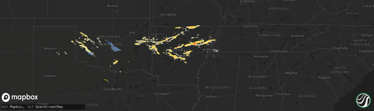
Hail
Wind
78,028
Estimated number of impacted properties by a 1.00" hail or larger18,299
Estimated number of impacted properties by a 1.75" hail or larger668
Estimated number of impacted properties by a 2.50" hail or largerStorm reports in Arkansas
Arkansas
| Date | Description |
|---|---|
| 10/15/20226:45 PM CDT | A local report indicates 1.50 inch wind near 3 NNW CROWS |
| 10/15/20226:43 PM CDT | A local report indicates 1.00 inch wind near 1 NE WATALULA |
| 10/15/20226:38 PM CDT | A local report indicates 1.00 inch wind near 2 NNW WATALULA |
| 10/15/20226:35 PM CDT | Thunderstorm wind gusts estimated to 60 mph. |
| 10/15/20226:35 PM CDT | Strong thunderstorm wind snapped large tree limbs. |
| 10/15/20226:35 PM CDT | Thunderstorm wind gusts es |
| 10/15/20226:34 PM CDT | Report from mping. |
| 10/15/20226:32 PM CDT | A local report indicates 1.00 inch wind near 1 ESE FORT SMITH |
| 10/15/20226:30 PM CDT | Time estimated from radar. |
| 10/15/20226:30 PM CDT | Strong thunderstorm wind blew down power lines. |
| 10/15/20226:24 PM CDT | A local report indicates 1.00 inch wind near 2 W BARLING |
| 10/15/20226:20 PM CDT | A local report indicates 1.00 inch wind near 1 S FORT SMITH |
| 10/15/20226:19 PM CDT | A local report indicates 1.25 inch wind near 2 WNW SODA VALLEY |
| 10/15/20225:56 PM CDT | Pictures of golfball sized hail shared to us via social media east of cabot... South of austin. |
| 10/15/20225:56 PM CDT | Pictures of golfball sized hail shared to us via social |
| 10/15/20225:48 PM CDT | A local report indicates 1.50 inch wind near 2 SE CABOT |
| 10/15/20225:46 PM CDT | A local report indicates 1.00 inch wind near HACKETT |
| 10/15/20225:09 PM CDT | A trained storm spotter measured spiky hail that was 2 inches in diameter. |
| 10/15/20225:01 PM CDT | Trained storm spotter reported quarter sized hail just east of the highway 31 and 38 intersection. |
| 10/15/20223:44 PM CDT | Ping pong ball sized hail reported about a mile south of nimrod lake. |
| 10/15/20225:24 AM CDT | At 1024 PM CDT, a severe thunderstorm was located near Ashport, or near Fort Pillow State Park, moving east at 35 mph. HAZARD...Golf ball size hail and 60 mph wind gusts. SOURCE...Radar indicated. IMPACT...People and animals outdoors will be injured. Expect hail damage to roofs, siding, windows, and vehicles. Expect wind damage to roofs, siding, and trees. Locations impacted include... Covington, Ripley, Fort Pillow State Park, Halls, Fulton, Nutbush, Forked Deer, Ashport, Ft Pillow, Henning, Gates, Gilt Edge, Burlison, Garland, Dryhill, Luckett, Flippin, Turnpike, Rialto and Curve. |
| 10/15/20224:56 AM CDT | At 955 PM CDT, a severe thunderstorm was located over Estes, or 12 miles southeast of Downtown Little Rock, moving east at 20 mph. HAZARD...60 mph wind gusts and quarter size hail. SOURCE...Radar indicated. IMPACT...Hail damage to vehicles is expected. Expect wind damage to roofs, siding, and trees. Locations impacted include... Little Rock... England... Wrightsville... Keo... Ironton... Estes... Toltec Mounds State Park... Sweet Home... State Fairgrounds... Scott... Baseline... Tucker... Higgins... College Station... Quapaw Quarter... Woodson... Hensley... Bredlow Corner... Willow Beach... Toltec... |
| 10/15/20224:32 AM CDT | At 931 PM CDT, a severe thunderstorm was located over Ironton, or 8 miles southeast of Southwest Little Rock, moving east at 25 mph. HAZARD...60 mph wind gusts and quarter size hail. SOURCE...Radar indicated. IMPACT...Hail damage to vehicles is expected. Expect wind damage to roofs, siding, and trees. Locations impacted include... Little Rock... North Little Rock... Bryant... Downtown Little Rock... Southwest Little Rock... Shannon Hills... Wrightsville... Redfield... Otter Creek... Ironton... Estes... Toltec Mounds State Park... East End... Orion... Sweet Home... Geyer Springs... Mabelvale... State Fairgrounds... Scott... Alexander... |
| 10/15/20224:07 AM CDT | At 906 PM CDT, a severe thunderstorm was located near Cherry Valley, or 7 miles south of Harrisburg, moving east at 35 mph. HAZARD...Golf ball size hail and 60 mph wind gusts. SOURCE...Radar indicated. IMPACT...People and animals outdoors will be injured. Expect hail damage to roofs, siding, windows, and vehicles. Expect wind damage to roofs, siding, and trees. Locations impacted include... Marked Tree, Harrisburg, Tyronza, Cherry Valley, Payneway, Wiley Crossing, Birdeye, Weona Junction, Weona, Stewart, Dub, Colton, Twist, Bay Village, Coldwater, Alto, Landers, Beasley, Boat Run and Spear Lake. |
| 10/15/20224:06 AM CDT | At 906 PM CDT, a severe thunderstorm was located near Moorefield, or 7 miles east of Batesville, moving east at 20 mph. HAZARD...60 mph wind gusts and quarter size hail. SOURCE...Radar indicated. IMPACT...Hail damage to vehicles is expected. Expect wind damage to roofs, siding, and trees. Locations impacted include... Batesville... Tuckerman... Newark... Strawberry... Lynn... Magness... Moorefield... Sulphur Rock... Aetna... Charlotte... Gainesboro... Pfeiffer... Dowdy... Kenyon... Elgin... Driftwood... Cord... |
| 10/15/20224:02 AM CDT | At 901 PM CDT, a severe thunderstorm was located over Benton, moving southeast at 20 mph. HAZARD...Ping pong ball size hail and 60 mph wind gusts. SOURCE...Radar indicated. IMPACT...People and animals outdoors will be injured. Expect hail damage to roofs, siding, windows, and vehicles. Expect wind damage to roofs, siding, and trees. Locations impacted include... Little Rock... Benton... Bryant... Southwest Little Rock... Haskell... Shannon Hills... Tull... Otter Creek... East End... Mabelvale... Salem in Saline County... Alexander... Bauxite... Avilla... Sardis... Shaw... Congo... Vimy Ridge... Grape... Parkers-Iron Springs... |
| 10/15/20224:01 AM CDT | At 901 PM CDT, a severe thunderstorm was located near Weiner, or 7 miles northwest of Harrisburg, moving east at 35 mph. HAZARD...Golf ball size hail and 60 mph wind gusts. SOURCE...Radar indicated. IMPACT...People and animals outdoors will be injured. Expect hail damage to roofs, siding, windows, and vehicles. Expect wind damage to roofs, siding, and trees. Locations impacted include... Jonesboro, Trumann, Harrisburg, Lake City, Lepanto, Bay, Greenfield, Hergett, Apt, Tulot, Hatchie Coon, Gum Point, Maple Grove, Promised Land, Cary, Judd Hill, Lache Lake, Poplar Ridge, Bunney and Lunsford. |
| 10/15/20223:33 AM CDT | At 833 PM CDT, a severe thunderstorm was located 7 miles southeast of Echo, or 8 miles north of Waldron, moving southeast at 30 mph. HAZARD...60 mph wind gusts and quarter size hail. SOURCE...Radar indicated. IMPACT...Hail damage to vehicles is expected. Expect wind damage to roofs, siding, and trees. Locations impacted include... Waldron... Oden... Cardiff... Gravelly... Union Hill... Olio... Hon... Cedar Creek... Bluffton... Nola... Needmore... Harvey... Parks... Blue Ball... Ione... Elm Park... Waltreak... |
| 10/15/20223:24 AM CDT | At 823 PM CDT, a severe thunderstorm was located 10 miles northwest of Salem in Saline County, or 13 miles northwest of Benton, moving east at 10 mph. HAZARD...Ping pong ball size hail and 60 mph wind gusts. SOURCE...Radar indicated. IMPACT...People and animals outdoors will be injured. Expect hail damage to roofs, siding, windows, and vehicles. Expect wind damage to roofs, siding, and trees. Locations impacted include... Little Rock... Benton... West Little Rock... Bryant... Shannon Hills... Pinnacle Mountain State Park... Salem in Saline County... Chenal Valley... Otter Creek... Alexander... Avilla... Congo... Grape... Bland... Ferndale... Natural Steps... |
| 10/15/20223:23 AM CDT | At 822 PM CDT, a severe thunderstorm was located near Algoa, or 7 miles southeast of Newport, moving east at 25 mph. HAZARD...60 mph wind gusts and half dollar size hail. SOURCE...Radar indicated. IMPACT...Hail damage to vehicles is expected. Expect wind damage to roofs, siding, and trees. Locations impacted include... Weiner, Cherry Valley, Hickory Ridge, Waldenburg, Fisher, Pitts, Hydrick, Wiley Crossing, Pittinger, Supply, Tilton, Brushy Lake, Mersman, Fair Field, Uno, Otwell and Bayou De View State Wildlife Management Area. |
| 10/15/20223:16 AM CDT | At 816 PM CDT, a severe thunderstorm was located over Echo, or 12 miles west of Booneville, moving east at 10 mph. HAZARD...Ping pong ball size hail and 60 mph wind gusts. SOURCE...Radar indicated. IMPACT...People and animals outdoors will be injured. Expect hail damage to roofs, siding, windows, and vehicles. Expect wind damage to roofs, siding, and trees. Locations impacted include... Booneville... Mansfield... Echo... Caulksville... Barber... Lucas... Chismville... Carolan... Grayson... Glendale in Logan County... Ione... Elm Park... |
| 10/15/20223:11 AM CDT | At 810 PM CDT, a severe thunderstorm was located near Burnville, moving east at 15 mph. HAZARD...Ping pong ball size hail and 60 mph wind gusts. SOURCE...Radar indicated. IMPACT...People and animals outdoors will be injured. Expect hail damage to roofs, siding, windows, and vehicles. Expect wind damage to roofs, siding, and trees. Locations in or near the path include... Charleston... Greenwood... Huntington... Washburn... Burnville... Fort Chaffee... Milltown... Crossroads... Witcherville... Dayton... |
| 10/15/20223:11 AM CDT | At 811 PM CDT, a severe thunderstorm was located 7 miles north of Tupelo, or 8 miles south of Newport, moving east at 40 mph. HAZARD...Half dollar size hail. SOURCE...Radar indicated. IMPACT...Damage to vehicles is expected. Locations impacted include... Newport... Augusta... Patterson... Grubbs... Tupelo... Algoa... McFadden... McCrory... Beedeville... Amagon... Balch... Blackville... Stegall... Fitzhugh... Erwin... Pumpkin Bend... |
| 10/15/20222:47 AM CDT | At 747 PM CDT, a severe thunderstorm was located over Quitman, or 11 miles southwest of Heber Springs, moving northeast at 25 mph. HAZARD...Ping pong ball size hail. SOURCE...Radar indicated. IMPACT...People and animals outdoors will be injured. Expect damage to roofs, siding, windows, and vehicles. Locations impacted include... Heber Springs... Quitman... Dam Site Marina... Hopewell in Cleburne County... Pearson... Eden Isle... Wilburn... |
| 10/15/20222:46 AM CDT | At 746 PM CDT, a severe thunderstorm was located near Pleasant Plains, or 17 miles northwest of Augusta, moving east at 30 mph. HAZARD...Half dollar size hail. SOURCE...Radar indicated. IMPACT...Damage to vehicles is expected. Locations impacted include... Newport... Diaz... Pleasant Plains... Oil Trough... Russell... Jacksonport... Tupelo... Bradford... Weldon... Olyphant... Shoffner... Thida... Ingleside... Heffington... Possum Grape... Denmark... Velvet Ridge... Macks... Roosevelt... |
| 10/15/20222:41 AM CDT | At 740 PM CDT, a severe thunderstorm was located 8 miles northeast of Hot Springs Village, moving east at 10 mph. HAZARD...Ping pong ball size hail and 60 mph wind gusts. SOURCE...Radar indicated. IMPACT...People and animals outdoors will be injured. Expect hail damage to roofs, siding, windows, and vehicles. Expect wind damage to roofs, siding, and trees. Locations impacted include... Bland... Paron... Reform... |
| 10/15/20222:25 AM CDT | At 724 PM CDT, a severe thunderstorm was located near Devils Knob, or 16 miles north of Clarksville, moving northeast at 35 mph. HAZARD...Golf ball size hail. SOURCE...Radar indicated. IMPACT...People and animals outdoors will be injured. Expect damage to roofs, siding, windows, and vehicles. Locations impacted include... Jasper... Dillen... Moore... Devils Knob... Piercetown... Walnut... Pruitt... Bertha... Rosetta... Upper Buffalo Wilderness Area... Ben Hur... Catalpa... Fort Douglas... Crossroad... Fallsville... Swain... Haw Creek Falls Campground... Gum Springs in Newton County... Oark... Nail... |
| 10/15/20222:21 AM CDT | At 721 PM CDT, a severe thunderstorm was located near Pangburn, or 12 miles north of Searcy, moving east at 30 mph. HAZARD...60 mph wind gusts and half dollar size hail. SOURCE...Radar indicated. IMPACT...Hail damage to vehicles is expected. Expect wind damage to roofs, siding, and trees. Locations impacted include... Pleasant Plains... Russell... Steprock... Albion... Hickory Flat... Clay... Providence... Dewey... Denmark... Sunnydale... Velvet Ridge... Roosevelt... |
| 10/15/20222:11 AM CDT | At 711 PM CDT, a severe thunderstorm was located 5 miles south of Muldrow, moving northeast at 20 mph. HAZARD...60 mph wind gusts and half dollar size hail. SOURCE...Radar indicated. IMPACT...Hail damage to vehicles is expected. Expect wind damage to roofs, siding, and trees. Locations in or near the path include... Fort Smith... Van Buren... Muldrow... Roland... Spiro... Arkoma... Moffett... Figure Five... Fort Smith Regional Airport... Short... Kibler... Shibley... Scullyville... Braden... Mill Creek... Cottonwood... Uniontown... Dora... Furry... This includes the following highways, Interstate 40 in Arkansas between mile markers 0 and 8. Interstate 40 in Oklahoma between mile markers 315 and 328. Interstate 540 between mile markers 1 and 12. |
| 10/15/20221:51 AM CDT | At 651 PM CDT, a severe thunderstorm was located over Lonoke, moving east at 10 mph. HAZARD...60 mph wind gusts and quarter size hail. SOURCE...Radar indicated. IMPACT...Hail damage to vehicles is expected. Expect wind damage to roofs, siding, and trees. Locations impacted include... Lonoke... Carlisle... McCreanor... Sisemore... Meto... Bevis Corner... Furlow... Woodlawn... Fairview in Lonoke County... |
| 10/15/20221:50 AM CDT | At 649 PM CDT, a severe thunderstorm was located over Rose Bud, or 10 miles south of Heber Springs, moving east at 30 mph. HAZARD...Half dollar size hail. SOURCE...Radar indicated. IMPACT...Damage to vehicles is expected. Locations impacted include... Quitman... Pangburn... Rose Bud... Crosby... Gravel Hill... Letona... Albion... Clay... Wilburn... Center Hill... Sidon... Hopewell in Cleburne County... Joy... Pickens in White County... Armstrong Springs... Dewey... |
| 10/15/20221:47 AM CDT | At 647 PM CDT, a severe thunderstorm was located 5 miles southeast of Cass, moving northeast at 15 mph. HAZARD...60 mph wind gusts and quarter size hail. SOURCE...Radar indicated. IMPACT...Hail damage to vehicles is expected. Expect wind damage to roofs, siding, and trees. Locations in or near the path include... Cass... Pettigrew... Boston... Taft... Red Star... Redding... |
| 10/15/20221:46 AM CDT | At 646 PM CDT, a severe thunderstorm was located near Cass, or 9 miles northeast of Ozark, moving northeast at 25 mph. HAZARD...60 mph wind gusts and quarter size hail. SOURCE...Radar indicated. IMPACT...Hail damage to vehicles is expected. Expect wind damage to roofs, siding, and trees. Locations impacted include... Devils Knob... Oak Grove in Johnson County... Salus... Wolf Pen Campground... Catalpa... Arbaugh... Yale... Friley... Ozone... Fallsville... Oark... Dixon Ridge... |
| 10/15/20221:43 AM CDT | At 643 PM CDT, a severe thunderstorm was located over Barling, moving northeast at 10 mph. HAZARD...60 mph wind gusts and quarter size hail. SOURCE...Radar indicated. IMPACT...Hail damage to vehicles is expected. Expect wind damage to roofs, siding, and trees. Locations in or near the path include... Fort Smith... Van Buren... Charleston... Greenwood... Alma... Barling... Lavaca... Mulberry... Dyer... Branch... Bloomer... Excelsior... Fort Smith Regional Airport... Jenny Lind... Kibler... Central City... Concord... Shibley... Rye Hill... Vesta...This includes the following highways, Interstate 40 in Arkansas between mile markers 5 and 20. Interstate 540 between mile markers 1 and 10. Interstate 49 near mile marker 22. |
| 10/15/20221:40 AM CDT | At 640 PM CDT, a severe thunderstorm was located 7 miles north of Lonsdale, or 8 miles east of Hot Springs Village, moving southeast at 20 mph. HAZARD...Ping pong ball size hail and 60 mph wind gusts. SOURCE...Radar indicated. IMPACT...People and animals outdoors will be injured. Expect hail damage to roofs, siding, windows, and vehicles. Expect wind damage to roofs, siding, and trees. Locations impacted include... Benton... Bryant... Hot Springs Village... Haskell... Traskwood... Lonsdale... Salem in Saline County... Alexander... Bauxite... Avilla... Nance... Congo... Grape... Bland... Crows... Owensville... |
| 10/15/20221:16 AM CDT | At 616 PM CDT, a severe thunderstorm was located near Thurman, or 11 miles west of Des Arc, moving east at 20 mph. HAZARD...Half dollar size hail. SOURCE...Radar indicated. IMPACT...Damage to vehicles is expected. Locations impacted include... Des Arc... Thurman... Sand Hill... Hayley... Jasmine... Hickory Plains... |
| 10/15/20221:09 AM CDT | At 608 PM CDT, a severe thunderstorm was located near Dyer, moving northeast at 35 mph. HAZARD...60 mph wind gusts and quarter size hail. SOURCE...Radar indicated. IMPACT...Hail damage to vehicles is expected. Expect wind damage to roofs, siding, and trees. Locations in or near the path include... Ozark... Mulberry... Dyer... Cass... Fern... Jethro... Barnes... Watalula... Piney... Toney... Turners Bend... Lonelm... Cravens... Paradise...This includes Interstate 40 in Arkansas between mile markers 15 and35. |
| 10/15/20221:09 AM CDT | At 609 PM CDT, a severe thunderstorm was located over Mallet Town, or 12 miles north of Conway, moving east at 30 mph. HAZARD...Golf ball size hail. SOURCE...Radar indicated. IMPACT...People and animals outdoors will be injured. Expect damage to roofs, siding, windows, and vehicles. Locations impacted include... Greenbrier... Wooster... Quitman... Guy... Damascus... Twin Groves... Mallet Town... Woolly Hollow State Park... Barney... Enders... Martinville... |
| 10/15/20221:00 AM CDT | At 600 PM CDT, a severe thunderstorm was located 9 miles southwest of Adona, or 12 miles southwest of Perryville, moving northeast at 20 mph. HAZARD...60 mph wind gusts and quarter size hail. SOURCE...Radar indicated. IMPACT...Hail damage to vehicles is expected. Expect wind damage to roofs, siding, and trees. Locations impacted include... Perryville... Oppelo... Perry... Adona... Wye Mountain... Williams Junction... Aplin... Antioch in Perry County... Wye... Deberrie... Oak Grove in Perry County... Long Mountain... Thornburg... Pleasant Valley in Perry County... Cherry Hill in Perry County... |
| 10/15/202212:58 AM CDT | At 558 PM CDT, a severe thunderstorm was located over Jenny Lind, moving east at 20 mph. HAZARD...60 mph wind gusts and half dollar size hail. SOURCE...Radar indicated. IMPACT...Hail damage to vehicles is expected. Expect wind damage to roofs, siding, and trees. Locations in or near the path include... Fort Smith... Greenwood... Barling... Lavaca... Hackett... Bloomer... Excelsior... Fort Smith Regional Airport... Burnville... Jenny Lind... Central City... Rye Hill... Ursula... This includes Interstate 540 between mile markers 12 and 14. |
| 10/15/202212:56 AM CDT | At 556 PM CDT, a severe thunderstorm was located 7 miles northeast of Hot Springs Village, moving east at 20 mph. HAZARD...60 mph wind gusts and quarter size hail. SOURCE...Radar indicated. IMPACT...Hail damage to vehicles is expected. Expect wind damage to roofs, siding, and trees. Locations impacted include... Hot Springs Village... Paron... Grape... Bland... Crows... Owensville... Reform... |
| 10/15/202212:41 AM CDT | At 541 PM CDT, a severe thunderstorm was located near Hattieville, or near Morrilton, moving northeast at 20 mph. HAZARD...Ping pong ball size hail and 60 mph wind gusts. SOURCE...Radar indicated. IMPACT...People and animals outdoors will be injured. Expect hail damage to roofs, siding, windows, and vehicles. Expect wind damage to roofs, siding, and trees. Locations impacted include... Morrilton... Oppelo... Bethlehem... Sequoya Park... Lanty... Hill Creek... Solgohachia... St. Vincent... Hattieville... Springfield... Middleton... Plumerville... Birdtown... Blackwell... Overcup... Wonderview... Kenwood... |
| 10/15/202212:27 AM CDT | At 527 PM CDT, a severe thunderstorm was located near Parnell, or near Jacksonville, moving east at 20 mph. HAZARD...60 mph wind gusts and quarter size hail. SOURCE...Radar indicated. IMPACT...Hail damage to vehicles is expected. Expect wind damage to roofs, siding, and trees. Locations impacted include... Jacksonville... Cabot... Little Rock AFB... Ward... Austin in Lonoke County... Thurman... Old Austin... Parnell... Sylvania... South Bend... Furlow... Butlerville... Woodlawn... Fairview in Lonoke County... |
| 10/15/202212:23 AM CDT | At 523 PM CDT, a severe thunderstorm was located near Barrettsville, or 10 miles northeast of Lonoke, moving southeast at 15 mph. HAZARD...Golf ball size hail and 60 mph wind gusts. SOURCE...Radar indicated. IMPACT...People and animals outdoors will be injured. Expect hail damage to roofs, siding, windows, and vehicles. Expect wind damage to roofs, siding, and trees. Locations impacted include... Hazen... Carlisle... Barrettsville... Prairie Center... Center Point... Screeton... |
| 10/15/202212:13 AM CDT | At 512 PM CDT, a severe thunderstorm was located 3 miles southwest of Pocola, moving east at 10 mph. HAZARD...60 mph wind gusts and half dollar size hail. SOURCE...Radar indicated. IMPACT...Hail damage to vehicles is expected. Expect wind damage to roofs, siding, and trees. Locations in or near the path include... Pocola... Hackett... Bonanza... Midland... Cameron... Excelsior... Jenny Lind... Rock Island... Jenson... Arkola... |
| 10/15/202212:12 AM CDT | At 511 PM CDT, a severe thunderstorm was located near Jessieville, or 8 miles north of Hot Springs Village, moving southeast at 10 mph. HAZARD...60 mph wind gusts and half dollar size hail. SOURCE...Radar indicated. IMPACT...Hail damage to vehicles is expected. Expect wind damage to roofs, siding, and trees. Locations impacted include... Hot Springs Village... Jessieville... Reform... Paron... |
| 10/15/202212:08 AM CDT | At 508 PM CDT, a severe thunderstorm was located near Petit Jean River WMA, or 10 miles south of Russellville, moving east at 20 mph. HAZARD...60 mph wind gusts and quarter size hail. SOURCE...Radar indicated. IMPACT...Hail damage to vehicles is expected. Expect wind damage to roofs, siding, and trees. Locations impacted include... Petit Jean State Park... Carden Bottoms... Casa... Aplin... Lakeview in Yell County... Holla Bend... Pontoon... Centerville... |
| 10/14/202211:47 PM CDT | At 447 PM CDT, a severe thunderstorm was located over Sylvania, or near Cabot, moving east at 10 mph. HAZARD...60 mph wind gusts and half dollar size hail. SOURCE...Radar indicated. IMPACT...Hail damage to vehicles is expected. Expect wind damage to roofs, siding, and trees. Locations impacted include... Ward... Carlisle... Barrettsville... Thurman... Sylvania... Hayley... Butlerville... Hickory Plains... Woodlawn... Screeton... |
| 10/14/202211:37 PM CDT | At 437 PM CDT, a severe thunderstorm was located 3 miles northwest of Cameron, moving east at 10 mph. HAZARD...60 mph wind gusts and half dollar size hail. SOURCE...Radar indicated. IMPACT...Hail damage to vehicles is expected. Expect wind damage to roofs, siding, and trees. Locations in or near the path include... Fort Smith... Poteau... Pocola... Spiro... Hackett... Bonanza... Midland... Cameron... Shady Point... Rock Island... Scullyville... Rye Hill... Jenson... |
| 10/14/202211:24 PM CDT | At 424 PM CDT, a severe thunderstorm was located 10 miles north of Jessieville, or 15 miles northwest of Hot Springs Village, moving southeast at 15 mph. HAZARD...60 mph wind gusts and half dollar size hail. SOURCE...Radar indicated. IMPACT...Hail damage to vehicles is expected. Expect wind damage to roofs, siding, and trees. Locations impacted include... Hot Springs Village... Long Mountain... Hollis... |
| 10/14/202210:48 PM CDT | At 348 PM CDT, a severe thunderstorm was located near Plainview in Yell County, or 13 miles southeast of Danville, moving southeast at 15 mph. HAZARD...60 mph wind gusts and half dollar size hail. SOURCE...Radar indicated. IMPACT...Hail damage to vehicles is expected. Expect wind damage to roofs, siding, and trees. Locations impacted include... Carter Cove Park... Hollis... Garden Point Recreation Area... Fourche Junction... Deberrie... Nimrod... |
| 10/14/202210:15 PM CDT | A local report indicates 1.00 inch wind near 3 N MOUNTAIN HOME |
| 10/14/202210:09 PM CDT | One inch hail reported at osceloa police hq. |
| 10/14/20229:50 PM CDT | Half dollar size hail in etowah. |
| 10/14/20229:40 PM CDT | **delayed report** received social media pictures of hail from near calico rock... Time estimated from radar data. |
| 10/14/20229:38 PM CDT | A local report indicates 1.00 inch wind near 1 WNW OLD JOE |
| 10/14/20229:36 PM CDT | 2 inch measured hail in lepanto. |
| 10/14/20229:31 PM CDT | Several car windshields were damaged. |
| 10/14/20229:27 PM CDT | Golf ball size hail reported in payneway. |
| 10/14/20229:25 PM CDT | A local report indicates 1.25 inch wind near ALEXANDER |
| 10/14/20229:23 PM CDT | A local report indicates 1.25 inch wind near 2 N SPRINGHILL |
| 10/14/20229:09 PM CDT | Occurred at the intersection of highway 65 and 74. |
| 10/14/20228:56 PM CDT | Half dollar size hail reported in weiner. |
| 10/14/20228:11 PM CDT | Golfball sized hail reported in paron... On highway 9 by ham radio operators. |
| 10/14/20227:59 PM CDT | **delayed report** received social media pictures of hail from near the independence and jackson co. Line... Between thida and possum grape. Time estimated from radar d |
| 10/14/20227:58 PM CDT | Received a report |
| 10/14/20227:58 PM CDT | Received a report of measured 3 hail in the town of olyphant... Right along t |
| 10/14/20227:37 PM CDT | Broadcast media shared a picture of hail at least 2 inches in diameter that broke the back window of a car in salus... Ar. |
| 10/14/20227:35 PM CDT | A picture of 1.5 inch hail was shared with the office from grubbs via twitter. |
| 10/14/20227:15 PM CDT | Ping pong ball sized hail was shared with the office via twitter with a picture. |
| 10/14/20227:04 PM CDT | 1.5 inch hail was reported via mping north of interstate 40 near the highway 31 and 236 intersection. |
All States Impacted by Hail Map on October 15, 2022
Cities Impacted by Hail Map on October 15, 2022
- Charlotte, AR
- Cord, AR
- Sulphur Rock, AR
- Batesville, AR
- Newark, AR
- Manila, AR
- Caraway, AR
- Hagarville, AR
- Lamar, AR
- Tyronza, AR
- Oakland, AR
- Yellville, AR
- Lakeview, AR
- Mountain Home, AR
- Bull Shoals, AR
- Midway, AR
- Wiseman, AR
- Horseshoe Bend, AR
- Center Ridge, AR
- Hartman, AR
- Leedey, OK
- Calumet, OK
- El Reno, OK
- Welling, OK
- Fort Gibson, OK
- Park Hill, OK
- Tahlequah, OK
- Leslie, AR
- Maricopa, AZ
- Leachville, AR
- Cabot, AR
- Memphis, TN
- Butler, OK
- Fort Smith, AR
- Claude, TX
- Jessieville, AR
- Redfield, AR
- Danville, AR
- Ola, AR
- Rover, AR
- Plainview, AR
- Calico Rock, AR
- Norfork, AR
- Hernando, MS
- San Tan Valley, AZ
- Stilwell, OK
- Mansfield, AR
- Wilson, OK
- Ozark, AR
- Bunch, OK
- Cookson, OK
- Hoxie, AR
- Lynn, AR
- Alicia, AR
- Swifton, AR
- Arnett, OK
- Vici, OK
- Turrell, AR
- Henderson, AR
- Weatherford, OK
- Geary, OK
- Cash, AR
- Custer City, OK
- Thomas, OK
- Arapaho, OK
- Clinton, OK
- Arlington, AZ
- Tonopah, AZ
- Buckeye, AZ
- Winkelman, AZ
- Vian, OK
- Sallisaw, OK
- Sheridan, AR
- Hensley, AR
- Jonesboro, AR
- Sherrill, AR
- Pottsboro, TX
- Sayre, OK
- Piedmont, OK
- North Little Rock, AR
- Little Rock, AR
- Gans, OK
- Muldrow, OK
- Lawton, OK
- Pettigrew, AR
- Briscoe, TX
- Sweetwater, OK
- Wheeler, TX
- Carter, OK
- Phoenix, AZ
- Ozone, AR
- Deer, AR
- Oark, AR
- Taloga, OK
- Greenfield, OK
- Watonga, OK
- Van Buren, AR
- Oxford, AR
- Salem, AR
- Hydro, OK
- Forrest City, AR
- Wynne, AR
- Cedarville, AR
- Altus, AR
- Harriet, AR
- Mount Judea, AR
- Rudy, AR
- Alma, AR
- Dyer, AR
- Charleston, AR
- Pelsor, AR
- Marshall, AR
- Uniontown, AR
- Dover, AR
- Witts Springs, AR
- Lavaca, AR
- Mulberry, AR
- Saint Joe, AR
- Mountainburg, AR
- Cecil, AR
- Clarksville, AR
- Chester, AR
- Ponca, AR
- Bradenton, FL
- Sarasota, FL
- Winslow, AR
- Bluffton, AR
- Reydon, OK
- West Fork, AR
- Elizabeth, AR
- England, AR
- Bryant, AR
- Mabelvale, AR
- Scott, AR
- Benton, AR
- Hot Springs Village, AR
- Paron, AR
- Lonsdale, AR
- Alexander, AR
- Perryville, AR
- Waldron, AR
- Mesa, AZ
- Eloy, AZ
- Picacho, AZ
- Vilonia, AR
- Enola, AR
- Greenbrier, AR
- Crawford, OK
- Cheyenne, OK
- Pindall, AR
- Everton, AR
- Elk City, OK
- Dardanelle, AR
- Casa, AR
- Belleville, AR
- Ardmore, OK
- Canehill, AR
- Natural Dam, AR
- Prairie Grove, AR
- Edmond, OK
- Gilbert, AZ
- Chandler, AZ
- Imperial, CA
- Germantown, TN
- Collierville, TN
- Hulbert, OK
- Wideman, AR
- Viola, AR
- Bexar, AR
- Corn, OK
- Myrtle, MO
- Hardy, AR
- Sturkie, AR
- Camp, AR
- Ravenden, AR
- Pocahontas, AR
- Mammoth Spring, AR
- Warner, OK
- Porum, OK
- Webbers Falls, OK
- Gore, OK
- Council Hill, OK
- Checotah, OK
- Braggs, OK
- Oktaha, OK
- Muskogee, OK
- Boynton, OK
- Valley Springs, AR
- Hammon, OK
- Fountain Hills, AZ
- Scottsdale, AZ
- Joiner, AR
- Dyess, AR
- Cordell, OK
- Russellville, AR
- Malvern, AR
- Carlisle, AR
- Henning, TN
- Winterhaven, CA
- Yuma, AZ
- Hackett, AR
- Cameron, OK
- Concord, AR
- Gatewood, MO
- Couch, MO
- Mountain View, OK
- Damascus, AR
- Bee Branch, AR
- Ravenden Springs, AR
- Doniphan, MO
- Glencoe, AR
- Thayer, MO
- Hartford, AR
- Winfield, KS
- Rock, KS
- Letona, AR
- Augusta, AR
- Lepanto, AR
- Pleasant Plains, AR
- Heber Springs, AR
- Osceola, AR
- Weiner, AR
- Bradford, AR
- Harrisburg, AR
- Keiser, AR
- Searcy, AR
- Fisher, AR
- Etowah, AR
- Floral, AR
- Beedeville, AR
- Cherry Valley, AR
- Judsonia, AR
- Hickory Ridge, AR
- Pangburn, AR
- Bald Knob, AR
- Oil Trough, AR
- Rose Bud, AR
- McCrory, AR
- Newport, AR
- Trumann, AR
- Marked Tree, AR
- Amagon, AR
- Wellton, AZ
- Lelia Lake, TX
- Springfield, AR
- Plumerville, AR
- Booneville, AR
- Ward, AR
- Lonoke, AR
- Brawley, CA
- Decatur, TX
- Minco, OK
- Springer, OK
- Davis, OK
- Dougherty, OK
- Sulphur, OK
- Dill City, OK
- Sentinel, OK
- Gotebo, OK
- Hobart, OK
- Canute, OK
- Lone Wolf, OK
- Des Arc, AR
- Quitman, AR
- Binger, OK
- Austin, AR
- Greenwood, AR
- Bigelow, AR
- Roland, AR
- Naples, FL
- Hickory Plains, AR
- Coolidge, AZ
- Little Rock Air Force Base, AR
- Jacksonville, AR
- Barling, AR
- Paradise Valley, AZ
- Roosevelt, OK
- Arkoma, OK
- Spiro, OK
- Pocola, OK
- Midland, AR
- Huntington, AR
- Atoka, OK
- Calexico, CA
- Solgohachia, AR
- Morrilton, AR
- Heber, CA
- El Centro, CA
- Hedley, TX
- Olive Branch, MS
- Hughes, AR
- Tecumseh, OK
- Ringling, OK
- Rocky, OK
- Florence, AZ
- Foss, OK
- Atkins, AR
- Widener, AR
- Gracemont, OK
- Carnegie, OK
- Lookeba, OK
- Fort Cobb, OK
- Heth, AR
- Farmersville, TX
- Greenville, TX
- Celeste, TX
- Guy, AR
- Clarendon, TX
- Sherwood, AR
- Conway, AR
- Cibola, AZ
- Griffithville, AR
- Peel, AR
- Queen Creek, AZ
- Casa Grande, AZ
- Rio Verde, AZ
- Fort Mcdowell, AZ
- Camargo, OK
- Bethany, OK
- Oklahoma City, OK
- Yukon, OK
- Jones, OK
- Lexington, OK
- Newalla, OK
- Konawa, OK
- Norman, OK
- Asher, OK
- Wanette, OK
- Macomb, OK
- Noble, OK
- Mcloud, OK
- Maud, OK
- Choctaw, OK
- Tucson, AZ
- Alvord, TX
- Chico, TX


