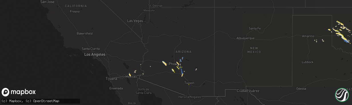
Hail Map in Arizona on October 15, 2022
The weather event in Arizona on October 15, 2022 includes Hail and Wind maps. 10 states and 336 cities were impacted and suffered possible damage. The total estimated number of properties impacted is 61,199.
Want more than just the map?
Turn this storm into a full workflow.
- Owner + property data so you know who to knock
- OnDemand branded weather history reports to win the "did we even have hail?" argument
- RoofTrace estimate so reps stop guessing numbers at the door
Bought this map? Upgrade within 7 days and we'll credit the $230. (10-15 min setup call)
Hail
Wind
61,199
Estimated number of impacted properties by a 1.00" hail or larger0
Estimated number of impacted properties by a 1.75" hail or larger0
Estimated number of impacted properties by a 2.50" hail or largerStorm reports in Arizona
Arizona
| Date | Description |
|---|---|
| 10/15/20226:01 PM CDT | Large hail on i-10 near picacho. |
| 10/15/20223:45 PM CDT | Large tree uprooted and fell onto a nearby suv. |
| 10/15/20223:08 PM CDT | Measured using a handheld anemometer... Associated with thunderstorm gust front. |
| 10/15/20227:54 AM CDT | At 1253 PM MST, severe thunderstorms were located along a line extending from near Sun Lakes to Freestone Park to Apache Junction, moving north at 30 mph. HAZARD...60 mph wind gusts. SOURCE...Radar indicated. IMPACT...Expect damage to roofs, siding, and trees. Locations impacted include... Phoenix, Mesa, Chandler, Glendale, Scottsdale, Gilbert, Tempe, Apache Junction, Fountain Hills, Paradise Valley, Laveen, East Mesa, Gold Canyon, Sugarloaf Mountain and Sun Lakes.This includes the following highways...AZ Interstate 10 between mile markers 140 and 176.AZ Interstate 17 between mile markers 195 and 209.AZ Route 51 between mile markers 1 and 15. |
| 10/15/20227:08 AM CDT | At 1208 PM MST, severe thunderstorms were located along a line extending from near Casa Grande to near Blackwater to 8 miles south of Boyce Thompson Arboretum, moving north at 35 mph. HAZARD...60 mph wind gusts. SOURCE...Radar indicated. IMPACT...Expect damage to roofs, siding, and trees. Locations impacted include... Mesa, Chandler, Gilbert, Casa Grande, Apache Junction, Florence, Coolidge, Gold Canyon, Sun Lakes, East Mesa, Queen Creek, Arizona City, La Palma, Gold Camp and Lost Dutchman State Park.This includes the following highways...AZ Interstate 10 between mile markers 168 and 204.AZ Interstate 8 between mile markers 171 and 178.US Highway 60 between mile markers 187 and 224. |
| 10/15/20225:56 AM CDT | At 1055 AM MST, a severe thunderstorm was located over Seville, or near Gilbert, moving north at 45 mph. HAZARD...60 mph wind gusts and penny size hail. SOURCE...Radar indicated. IMPACT...Expect damage to roofs, siding, and trees. Locations impacted include... Phoenix, Mesa, Chandler, Scottsdale, Gilbert, Tempe, Fountain Hills, Paradise Valley, East Mesa, Sun Lakes, Queen Creek, Tempe Marketplace, Papago Park, Piestewa Peak Park and Falcon Field Airport.This includes the following highways...AZ Interstate 10 between mile markers 152 and 157.AZ Route 51 between mile markers 1 and 6.US Highway 60 between mile markers 173 and 190. |
| 10/15/20225:42 AM CDT | At 1042 AM MST, a severe thunderstorm was located over San Xavier Community, or near Tucson, moving north at 25 mph. HAZARD...60 mph wind gusts and quarter size hail. SOURCE...Radar indicated. IMPACT...Hail damage to vehicles is expected. Expect wind damage to roofs, siding, and trees. Locations impacted include... Tucson, Marana, Davis-Monthan Air Force Base, Casas Adobes, Drexel Heights, Flowing Wells, South Tucson, Pascua Pueblo Yaqui Reservation, Catalina Foothills, Tucson International Airport, Valencia West, Summit, Tucson Estates and San Xavier Mission. |
| 10/15/20225:00 AM CDT | At 1000 PM MST, a severe thunderstorm was located 9 miles southwest of Estrella Mountain Ranch, or 12 miles southwest of Goodyear, moving northwest at 25 mph. HAZARD...Ping pong ball size hail and 60 mph wind gusts. SOURCE...Radar indicated. IMPACT...People and animals outdoors will be injured. Expect hail damage to roofs, siding, windows, and vehicles. Expect wind damage to roofs, siding, and trees. Locations impacted include... Goodyear, Buckeye, Palo Verde, Painted Rock Dam, Liberty, Perryville, Rainbow Valley, Hassayampa and Arlington.This includes the following highways...AZ Interstate 10 between mile markers 112 and 119.AZ Route 85 between mile markers 135 and 154. |
| 10/15/20224:01 AM CDT | At 900 PM MST, a severe thunderstorm was located 18 miles west of Tonopah, moving northwest at 20 mph. HAZARD...60 mph wind gusts and quarter size hail. SOURCE...Radar indicated. IMPACT...Hail damage to vehicles is expected. Expect wind damage to roofs, siding, and trees. This severe thunderstorm will remain over mainly rural areas of east central La Paz and Maricopa Counties.This includes AZ Interstate 10 between mile markers 59 and 84. |
| 10/15/20223:35 AM CDT | Report of quarter sized hail near scottsdale road and doubletree ranch rd. |
| 10/15/20223:25 AM CDT | Hailstones up to 2 inches in diameter reported near 64th st. And shea blvd. |
| 10/15/20222:45 AM CDT | Hailstones up to 1.5 inches in diameter reported in mesa near brown rd. And gilbert rd. |
| 10/15/20222:25 AM CDT | At 724 PM MST, a severe thunderstorm was located 7 miles northwest of Tonopah, moving northwest at 25 mph. HAZARD...Ping pong ball size hail and 60 mph wind gusts. SOURCE...Radar indicated. IMPACT...People and animals outdoors will be injured. Expect hail damage to roofs, siding, windows, and vehicles. Expect wind damage to roofs, siding, and trees. This severe thunderstorm will remain over mainly rural areas of Maricopa County.This includes AZ Interstate 10 between mile markers 86 and 93. |
| 10/15/20221:50 AM CDT | Hailstones up to 1 inch in diameter reported near ellsworth rd. And riggs rd. Most of the hail was pea sized. |
| 10/15/20221:49 AM CDT | At 649 PM MST, a severe thunderstorm was located 7 miles southwest of Buckeye, moving northwest at 30 mph. HAZARD...Ping pong ball size hail and 60 mph wind gusts. SOURCE...Radar indicated. IMPACT...People and animals outdoors will be injured. Expect hail damage to roofs, siding, windows, and vehicles. Expect wind damage to roofs, siding, and trees. Locations impacted include... Buckeye, Tonopah, Palo Verde Nuclear Generation Station, Wintersburg and Hassayampa.This includes the following highways...AZ Interstate 10 between mile markers 92 and 114.AZ Route 85 between mile markers 152 and 154. |
| 10/15/20221:24 AM CDT | At 623 PM MST, severe thunderstorms were located along a line extending from near Tonto Basin to near Sycamore Creek to near Horseshoe Reservoir to Camp Creek, moving north at 45 mph. HAZARD...60 to 65 mph wind gusts and quarter size hail. SOURCE...Radar indicated. IMPACT...Hail damage to vehicles is expected. Expect wind damage to roofs, siding, and trees. Locations impacted include... Payson, Oxbow Estates, Round Valley, Horseshoe Reservoir, Rye, Deer Creek and Tonto Natural Bridge State Park.This includes the following highways... State Route 260 near mile marker 252. State Route 188 between mile markers 275 and 276. State Route 87 southbound between mile markers 241 and 251. State Route 87 between mile markers 230 and 253, and near milemarker 262. |
| 10/15/20221:17 AM CDT | At 617 PM MST, severe thunderstorms were located along a line extending from near Sunflower to near Sycamore Creek to 8 miles east of Camp Creek to 6 miles northwest of Rio Verde, moving north at 50 mph. HAZARD...60 mph wind gusts. SOURCE...Radar indicated. IMPACT...Expect damage to roofs, siding, and trees. Locations impacted include... Scottsdale, Sycamore Creek, Sunflower, Desert Mountain, Camp Creek, Horseshoe Reservoir and Seven Springs.This includes AZ Route 87 between mile markers 215 and 229. |
| 10/15/20221:01 AM CDT | At 600 PM MST, a severe thunderstorm was located over Tonopah, moving northwest at 30 mph. HAZARD...60 mph wind gusts and quarter size hail. SOURCE...Radar indicated. IMPACT...Hail damage to vehicles is expected. Expect wind damage to roofs, siding, and trees. Locations impacted include... Tonopah and Wintersburg. This includes AZ Interstate 10 between mile markers 82 and 103. |
| 10/15/202212:41 AM CDT | At 540 PM MST, severe thunderstorms were located along a line extending from Saguaro Lake to near Granite Reef Dam to Gilbert to near Seville, moving north at 35 mph. HAZARD...60 mph wind gusts. SOURCE...Radar indicated. IMPACT...Expect damage to roofs, siding, and trees. Locations impacted include... Phoenix, Mesa, Chandler, Scottsdale, Gilbert, Tempe, Apache Junction, Fountain Hills, Paradise Valley, East Mesa, Sugarloaf Mountain, Sun Lakes, Ballantine Trailhead, Round Valley and Queen Creek.This includes the following highways...AZ Interstate 10 between mile markers 144 and 184.AZ Interstate 17 between mile markers 195 and 196.AZ Route 51 between mile markers 1 and 6, and near mile marker 9. |
| 10/15/202212:13 AM CDT | At 512 PM MST, a severe thunderstorm was located near Aravaipa Canyon Wilderness, or 11 miles northeast of Mammoth, moving north at 25 mph. HAZARD...60 mph wind gusts and nickel size hail. SOURCE...Radar indicated. IMPACT...Expect damage to roofs, siding, and trees. Locations impacted include... Aravaipa Canyon Wilderness and San Carlos Reservoir. |
| 10/15/202212:01 AM CDT | At 501 PM MST, severe thunderstorms were located along a line extending from near Florence Junction to Magma to near Blackwater to near Coolidge, moving north at 45 mph. HAZARD...70 mph wind gusts. SOURCE...Radar indicated. IMPACT...Expect considerable tree damage. Damage is likely to mobile homes, roofs, and outbuildings. Locations impacted include... Mesa, Gilbert, Apache Junction, Coolidge, Gold Canyon, Queen Creek, Blackwater, Chandler Heights, Gold Camp, Lost Dutchman State Park, Goldfield, Magma, San Tan Village Mall, San Tan Valley and Seville.This includes the following highways...US Highway 60 between mile markers 190 and 217.AZ Route 87 between mile markers 134 and 149.AZ Route 202 between mile markers 29 and 41. |
| 10/14/202211:32 PM CDT | At 432 PM MST, severe thunderstorms were located along a line extending from 16 miles southeast of Florence to 9 miles southeast of Coolidge Airport to near Picacho, moving northwest at 30 mph. HAZARD...60 mph wind gusts and penny size hail. SOURCE...Radar indicated. IMPACT...Expect damage to roofs, siding, and trees. Locations impacted include... Florence, Coolidge, La Palma, Blackwater, Magma, Randolph, Coolidge Airport and Valley Farms.This includes the following highways...AZ Route 87 between mile markers 124 and 144.AZ Route 79 between mile markers 130 and 145. |
| 10/14/202211:16 PM CDT | At 416 PM MST, severe thunderstorms were located along a line extending from 17 miles southwest of Kearny to 6 miles north of Picacho Peak State Park to 12 miles south of Arizona City, moving north at 25 mph. HAZARD...60 mph wind gusts and penny size hail. SOURCE...Radar indicated. IMPACT...Expect damage to roofs, siding, and trees. Locations impacted include... Eloy, Picacho, Picacho Peak State Park, Cactus Forest and East Chui-Chu. |
| 10/14/202211:11 PM CDT | At 411 PM MST/411 PM PDT/, a severe thunderstorm was located 8 miles southwest of Martinez Lake, moving northwest at 20 mph. HAZARD...60 mph wind gusts and quarter size hail. SOURCE...Radar indicated. IMPACT...Hail damage to vehicles is expected. Expect wind damage to roofs, siding, and trees. This severe thunderstorm will remain over mainly rural areas of southwestern La Paz and east central Imperial Counties. |
| 10/14/202210:49 PM CDT | At 349 PM MST, severe thunderstorms were located along a line extending from near Picacho to near Chui-Chu, moving north at 35 mph. HAZARD...60 mph wind gusts and quarter size hail. SOURCE...Radar indicated. IMPACT...Hail damage to vehicles is expected. Expect wind damage to roofs, siding, and trees. Locations impacted include... Casa Grande, Florence, Coolidge, Maricopa, Queen Creek, Arizona City, La Palma, Blackwater, Toltec, Magma, San Tan Valley, Coolidge Airport, Bapchule, Olberg and Arizola.This includes the following highways...AZ Interstate 10 between mile markers 172 and 204.AZ Interstate 8 between mile markers 160 and 178.US Highway 60 between mile markers 214 and 217. |
| 10/14/202210:36 PM CDT | At 335 PM MST, a couple of severe thunderstorms were located 7 miles south an 10 miles southwest of Picacho, or 22 to 25 miles southeast of Casa Grande, moving north at 25 mph. HAZARD...60 mph wind gusts and quarter size hail. SOURCE...Radar indicated. IMPACT...Hail damage to vehicles is expected. Expect wind damage to roofs, siding, and trees. Locations impacted include... Eloy, Picacho, Chui-Chu, Picacho Peak State Park, Shopishk and East Chui-Chu. |
| 10/14/20229:32 PM CDT | At 232 PM MST/232 PM PDT/, a severe thunderstorm was located over Palo Verde, or 32 miles north of Martinez Lake, moving west at 15 mph. HAZARD...60 mph wind gusts and quarter size hail. SOURCE...Radar indicated. IMPACT...Hail damage to vehicles is expected. Expect wind damage to roofs, siding, and trees. Locations impacted include... Blythe, Cibola and Palo Verde. This includes CA Route 78 between mile markers 74 and 80. |
| 10/14/20229:07 PM CDT | A local report indicates 68 MPH wind near 7 NE WINTERSBURG |
| 10/14/20229:03 PM CDT | Several trees were snapped. Downed power poles affecting 121 customers was reported by the utility company in an area between 379th avenue and 355th avenue and between |
| 10/14/20229:00 PM CDT | Several trees uprooted and power poles snapped. |
| 10/14/20228:49 PM CDT | Corrects previous tstm wnd dmg report from 8 e wintersburg. Downed power poles affecting 41 customers were reported between buchanan street to yuma road and between pow |
| 10/14/20228:48 PM CDT | Downed power poles affecting 41 customers were reported between buchanan street to yuma road and between powers butte road to johnson road. |
| 10/14/20228:38 PM CDT | At 137 PM MST, severe thunderstorms were located along a line extending from near Round Valley to near Scottsdale to near Downtown Glendale, moving north at 35 mph. HAZARD...60 mph wind gusts. SOURCE...Radar indicated. IMPACT...Expect damage to roofs, siding, and trees. Locations impacted include... Phoenix, Scottsdale, Fountain Hills, Paradise Valley, Sugarloaf Mountain, New River, Sycamore Creek, Ballantine Trailhead, Round Valley, Sunflower, Cave Creek, Carefree, Papago Park, Piestewa Peak Park and Deer Valley Airport.This includes the following highways...AZ Interstate 17 between mile markers 209 and 241.AZ Route 51 between mile markers 1 and 15.AZ Route 87 between mile markers 202 and 219. |
| 10/14/20228:27 PM CDT | At 126 PM MST, severe thunderstorms were located along a line extending from Downtown Phoenix to near South Mountain Park to 8 miles east of Estrella, moving northwest at 25 mph. HAZARD...60 mph wind gusts. Blowing dust with visibility as low as one mile. SOURCE...Radar indicated. IMPACT...Expect damage to roofs, siding, and trees. Locations impacted include... Phoenix, Glendale, Peoria, Surprise, Avondale, Goodyear, Buckeye, El Mirage, Tolleson, Youngtown, Sun City West, Waddell, Laveen, Cashion and Sun City.This includes the following highways...AZ Interstate 10 between mile markers 115 and 152.AZ Interstate 17 between mile markers 195 and 210.AZ Route 51 near mile marker 1. |
| 10/14/20228:05 PM CDT | Power poles downed in tonapah affecting 96 customers in an area between 425th drive to 411th ave and between glendale avenue and i-10. |
| 10/14/20227:40 PM CDT | Downed powerlines affecting 252 customers were reported in an area between the hassayampa river to elliot road to 355th avenue to wintersburg road. |
| 10/14/20227:39 PM CDT | 18 power poles affecting 52 customers were downed in an area between s higley road and s mandarin drive and between e san tan blvd and w san dance drive. Winds were est |
| 10/14/20227:15 PM CDT | Corrects previous tstm wnd dmg report from 4 sw queen creek. Corrects previous tstm wnd dmg report from 4 sw queen creek. Powerlines downed along e tangelo avenue and h |
All States Impacted by Hail Map on October 15, 2022
Cities Impacted by Hail Map on October 15, 2022
- Charlotte, AR
- Cord, AR
- Sulphur Rock, AR
- Batesville, AR
- Newark, AR
- Manila, AR
- Caraway, AR
- Hagarville, AR
- Lamar, AR
- Tyronza, AR
- Oakland, AR
- Yellville, AR
- Lakeview, AR
- Mountain Home, AR
- Bull Shoals, AR
- Midway, AR
- Wiseman, AR
- Horseshoe Bend, AR
- Center Ridge, AR
- Hartman, AR
- Leedey, OK
- Calumet, OK
- El Reno, OK
- Welling, OK
- Fort Gibson, OK
- Park Hill, OK
- Tahlequah, OK
- Leslie, AR
- Maricopa, AZ
- Leachville, AR
- Cabot, AR
- Memphis, TN
- Butler, OK
- Fort Smith, AR
- Claude, TX
- Jessieville, AR
- Redfield, AR
- Danville, AR
- Ola, AR
- Rover, AR
- Plainview, AR
- Calico Rock, AR
- Norfork, AR
- Hernando, MS
- San Tan Valley, AZ
- Stilwell, OK
- Mansfield, AR
- Wilson, OK
- Ozark, AR
- Bunch, OK
- Cookson, OK
- Hoxie, AR
- Lynn, AR
- Alicia, AR
- Swifton, AR
- Arnett, OK
- Vici, OK
- Turrell, AR
- Henderson, AR
- Weatherford, OK
- Geary, OK
- Cash, AR
- Custer City, OK
- Thomas, OK
- Arapaho, OK
- Clinton, OK
- Arlington, AZ
- Tonopah, AZ
- Buckeye, AZ
- Winkelman, AZ
- Vian, OK
- Sallisaw, OK
- Sheridan, AR
- Hensley, AR
- Jonesboro, AR
- Sherrill, AR
- Pottsboro, TX
- Sayre, OK
- Piedmont, OK
- North Little Rock, AR
- Little Rock, AR
- Gans, OK
- Muldrow, OK
- Lawton, OK
- Pettigrew, AR
- Briscoe, TX
- Sweetwater, OK
- Wheeler, TX
- Carter, OK
- Phoenix, AZ
- Ozone, AR
- Deer, AR
- Oark, AR
- Taloga, OK
- Greenfield, OK
- Watonga, OK
- Van Buren, AR
- Oxford, AR
- Salem, AR
- Hydro, OK
- Forrest City, AR
- Wynne, AR
- Cedarville, AR
- Altus, AR
- Harriet, AR
- Mount Judea, AR
- Rudy, AR
- Alma, AR
- Dyer, AR
- Charleston, AR
- Pelsor, AR
- Marshall, AR
- Uniontown, AR
- Dover, AR
- Witts Springs, AR
- Lavaca, AR
- Mulberry, AR
- Saint Joe, AR
- Mountainburg, AR
- Cecil, AR
- Clarksville, AR
- Chester, AR
- Ponca, AR
- Bradenton, FL
- Sarasota, FL
- Winslow, AR
- Bluffton, AR
- Reydon, OK
- West Fork, AR
- Elizabeth, AR
- England, AR
- Bryant, AR
- Mabelvale, AR
- Scott, AR
- Benton, AR
- Hot Springs Village, AR
- Paron, AR
- Lonsdale, AR
- Alexander, AR
- Perryville, AR
- Waldron, AR
- Mesa, AZ
- Eloy, AZ
- Picacho, AZ
- Vilonia, AR
- Enola, AR
- Greenbrier, AR
- Crawford, OK
- Cheyenne, OK
- Pindall, AR
- Everton, AR
- Elk City, OK
- Dardanelle, AR
- Casa, AR
- Belleville, AR
- Ardmore, OK
- Canehill, AR
- Natural Dam, AR
- Prairie Grove, AR
- Edmond, OK
- Gilbert, AZ
- Chandler, AZ
- Imperial, CA
- Germantown, TN
- Collierville, TN
- Hulbert, OK
- Wideman, AR
- Viola, AR
- Bexar, AR
- Corn, OK
- Myrtle, MO
- Hardy, AR
- Sturkie, AR
- Camp, AR
- Ravenden, AR
- Pocahontas, AR
- Mammoth Spring, AR
- Warner, OK
- Porum, OK
- Webbers Falls, OK
- Gore, OK
- Council Hill, OK
- Checotah, OK
- Braggs, OK
- Oktaha, OK
- Muskogee, OK
- Boynton, OK
- Valley Springs, AR
- Hammon, OK
- Fountain Hills, AZ
- Scottsdale, AZ
- Joiner, AR
- Dyess, AR
- Cordell, OK
- Russellville, AR
- Malvern, AR
- Carlisle, AR
- Henning, TN
- Winterhaven, CA
- Yuma, AZ
- Hackett, AR
- Cameron, OK
- Concord, AR
- Gatewood, MO
- Couch, MO
- Mountain View, OK
- Damascus, AR
- Bee Branch, AR
- Ravenden Springs, AR
- Doniphan, MO
- Glencoe, AR
- Thayer, MO
- Hartford, AR
- Winfield, KS
- Rock, KS
- Letona, AR
- Augusta, AR
- Lepanto, AR
- Pleasant Plains, AR
- Heber Springs, AR
- Osceola, AR
- Weiner, AR
- Bradford, AR
- Harrisburg, AR
- Keiser, AR
- Searcy, AR
- Fisher, AR
- Etowah, AR
- Floral, AR
- Beedeville, AR
- Cherry Valley, AR
- Judsonia, AR
- Hickory Ridge, AR
- Pangburn, AR
- Bald Knob, AR
- Oil Trough, AR
- Rose Bud, AR
- McCrory, AR
- Newport, AR
- Trumann, AR
- Marked Tree, AR
- Amagon, AR
- Wellton, AZ
- Lelia Lake, TX
- Springfield, AR
- Plumerville, AR
- Booneville, AR
- Ward, AR
- Lonoke, AR
- Brawley, CA
- Decatur, TX
- Minco, OK
- Springer, OK
- Davis, OK
- Dougherty, OK
- Sulphur, OK
- Dill City, OK
- Sentinel, OK
- Gotebo, OK
- Hobart, OK
- Canute, OK
- Lone Wolf, OK
- Des Arc, AR
- Quitman, AR
- Binger, OK
- Austin, AR
- Greenwood, AR
- Bigelow, AR
- Roland, AR
- Naples, FL
- Hickory Plains, AR
- Coolidge, AZ
- Little Rock Air Force Base, AR
- Jacksonville, AR
- Barling, AR
- Paradise Valley, AZ
- Roosevelt, OK
- Arkoma, OK
- Spiro, OK
- Pocola, OK
- Midland, AR
- Huntington, AR
- Atoka, OK
- Calexico, CA
- Solgohachia, AR
- Morrilton, AR
- Heber, CA
- El Centro, CA
- Hedley, TX
- Olive Branch, MS
- Hughes, AR
- Tecumseh, OK
- Ringling, OK
- Rocky, OK
- Florence, AZ
- Foss, OK
- Atkins, AR
- Widener, AR
- Gracemont, OK
- Carnegie, OK
- Lookeba, OK
- Fort Cobb, OK
- Heth, AR
- Farmersville, TX
- Greenville, TX
- Celeste, TX
- Guy, AR
- Clarendon, TX
- Sherwood, AR
- Conway, AR
- Cibola, AZ
- Griffithville, AR
- Peel, AR
- Queen Creek, AZ
- Casa Grande, AZ
- Rio Verde, AZ
- Fort Mcdowell, AZ
- Camargo, OK
- Bethany, OK
- Oklahoma City, OK
- Yukon, OK
- Jones, OK
- Lexington, OK
- Newalla, OK
- Konawa, OK
- Norman, OK
- Asher, OK
- Wanette, OK
- Macomb, OK
- Noble, OK
- Mcloud, OK
- Maud, OK
- Choctaw, OK
- Tucson, AZ
- Alvord, TX
- Chico, TX


