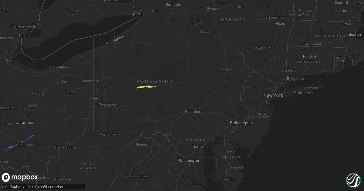
Hail Map in Pennsylvania on October 15, 2021
Get this storm
October 15 map
$229
one time, instant access
Download today. No call, no setup
Keep the $229
Bought the map and want the full workflow? Apply the entire $229 to a subscription within 7 days. None of it is wasted.
Every map, not just this one
This buys you this map. Subscription and you get every map we run, in the markets you choose from a few cities to whole states to nationwide. Plus real-time alerts the moment a storm fires.
Contact data
Name, contact info, occupancy, even credit band for addresses in the footprint. You go from where it hit to who to call.
Become the source they trust
Unlimited branding weather history reports on demand. You already have the documented answer ready for the property owner, and you are the one who showed up with it.
Property data and RoofTrace estimates
Pull up any address you have got, its value and the exact code rules for that jurisdiction, straight from One Click Code. Then RoofTrace estimates the squares, pitch, and roof value, priced the way you price.
Storm reports in Pennsylvania
Pennsylvania
| Date | Description |
|---|---|
| 10/15/20211:46 PM CDT | Several trees and power lines were blown down. |
| 10/15/202111:58 AM CDT | Tree down. |
| 10/15/202111:52 AM CDT | Multiple trees down from grampian to glen richey. |
| 10/15/20217:58 AM CDT | At 1258 PM EDT, a severe thunderstorm was located near Curwensville, moving east at 30 mph. HAZARD...60 mph wind gusts and quarter size hail. SOURCE...Radar indicated. IMPACT...Hail damage to vehicles is expected. Expect wind damage to roofs, siding, and trees. Locations impacted include... Clearfield, Philipsburg, Woodland, Curwensville, Hyde, Osceola Mills, Plymptonville, Chester Hill, North Philipsburg, South Philipsburg, Moshannon, Black Moshannon State Park, Jeffries, Morrisdale, West Decatur, Grassflat, Kylertown and Wallaceton.For those driving on Interstate 80, this includes areas between theClearfield and Snow Shoe exits, specifically from mile markers 120 to143.This includes Interstate 99 near mile marker 64. |
| 10/15/20217:17 AM CDT | At 1217 PM EDT, a severe thunderstorm was located 10 miles east of Punxsutawney, moving east at 25 mph. HAZARD...60 mph wind gusts and quarter size hail. SOURCE...Radar indicated. IMPACT...Hail damage to vehicles is expected. Expect wind damage to roofs, siding, and trees. Locations impacted include... Clearfield, Woodland, Curwensville, Hyde, Plymptonville, Rockton, S.B. Elliot State Park, Grampian, Wallaceton, Troutville, Lumber City and Clearfield-Lawrence Airport.For those driving on Interstate 80, this includes areas between theDubois Route 255 and Kylertown exits, specifically from mile markers110 to 125. |
| 10/15/20216:55 AM CDT | Report of damage to multiple utility poles and trees down on wires. Time estimated based on radar. |
| 10/15/20216:42 AM CDT | Report of multiple downed trees and roof damage to 2 home in monroe and millcreek townships. |
| 10/15/20216:41 AM CDT | Pictures of snapped trees and trees down on power lines along south reisburg road in monroe township. Time estimated based on radar. |
| 10/15/20216:40 AM CDT | Corrected time from 226 pm. Multiple trees reported down on divens road... Damage to a house on south reidsburg road. Time estimated based on radar. |
| 10/15/20216:04 AM CDT | Pictures show large trees snapped near the base in the chicora and keppels corner area. Time estimated based on radar. |
| 10/15/20215:53 AM CDT | Pictures of snapped trees near east butler. Time estimated based on radar |
| 10/15/20215:34 AM CDT | Large oak tree snapped and toppled maple trees on old route 68 |
| 10/15/20215:30 AM CDT | Multiple reports of tree damage in cranberry township. Time estimated based on radar. |
| 10/15/20215:20 AM CDT | Large trees uprooted. Time estimated from radar |
| 10/15/20215:19 AM CDT | Reports and pictures of damage to trees and outdoor sheds. Time estimated based on radar. |
| 10/15/20215:16 AM CDT | Ef1 tornado |
| 10/15/20215:16 AM CDT | Numerous pictures showing snapped and uprooted trees... Downed power lines... And home damage. Time estimated based on radar. |
| 10/15/20215:14 AM CDT | Report of a destroyed mobile home and several trees and limbs down. Time estimated based on radar. |
| 10/15/20215:13 AM CDT | Pictures show downed trees and telephone poles on 9th street extension in new sewickley township - possible tornado damage. Time estimated from radar. |
| 10/15/20215:12 AM CDT | Pictures show tree limbs and trunks snapped in monaca heights area. Time estimated from radar. |
| 10/15/20215:07 AM CDT | Ef0 tornado |
| 10/14/20219:43 PM CDT | At 242 PM EDT, a severe thunderstorm was located near Guys Mills, or near Meadville, moving east at 30 mph. HAZARD...60 mph wind gusts and quarter size hail. SOURCE...Radar indicated. IMPACT...Minor damage to vehicles is possible. Expect damage to trees and power lines. Locations impacted include... Titusville, Riceville, Guys Mills, Hydetown, Blooming Valley, Townville and Spartansburg. |
All States Impacted by Hail Map on October 15, 2021
Cities Impacted by Hail Map on October 15, 2021
- Ripley, TN
- Brownsville, TN
- Clearfield, PA
- Curwensville, PA
- Palestine, AR
- Cotton Plant, AR
- Des Arc, AR
- Wilson, AR
- Osceola, AR
- Adona, AR
- Perry, AR
- Houston, AR
- Morrilton, AR
- Sharon, TN
- Newbern, TN
- Kenton, TN
- Dyer, TN
- Rutherford, TN
- Greenfield, TN
- Big Sandy, TN
- Springville, TN
- Bells, TN
- Cabot, AR
- Hanover, IN
- Lexington, IN
- Underwood, IN
- Scottsburg, IN
- Newport, AR
- Plainview, AR
- Paron, AR
- Casa, AR
- Dardanelle, AR
- Bigelow, AR
- Conway, AR
- Scott, AR
- Morrisdale, PA
- West Decatur, PA
- Wallaceton, PA
- Waverly, TN
- McEwen, TN
- Evansville, IN
- Lepanto, AR
- Joiner, AR
- Marked Tree, AR
- Dyess, AR
- Etowah, AR
- Keiser, AR
- Mahaffey, PA
- Lonoke, AR
- Austin, AR
- Jacksonville, AR
- Ward, AR
- Coldwater, MS
- Senatobia, MS
- Holly Springs, MS
- Robinsonville, MS
- Amagon, AR
- Cash, AR
- Nabb, IN
- Henryville, IN
- Perryville, AR
- Philipsburg, PA
- Benton, IL
- Sesser, IL
- Whittington, IL
- Ewing, IL
- Ola, AR
- Danville, AR
- Jackson, TN
- Humboldt, TN
- Cedar Hill, TN
- Adams, TN
- Grampian, PA
- Olanta, PA
- Punxsutawney, PA
- Glen Richey, PA
- Madison, IN
- Marysville, IN
- Trumann, AR
- Bay, AR
- Wheatley, AR
- Brinkley, AR
- Belleville, AR
- Plumerville, AR
- Springfield, TN
- Cross Plains, TN
- England, AR
- Little Rock, AR
- Covington, TN
- Mayflower, AR
- Roland, AR
- Rossiter, PA
- Gadsden, TN
- Alamo, TN
- Forrest City, AR
- Goodwin, AR
- Henning, TN
- Mount Vernon, IN
- Monaca, PA
- Industry, PA
- Hookstown, PA
- Aliquippa, PA
- Midland, PA
- Georgetown, PA
- Shippingport, PA
- Butler, PA
- East Butler, PA
- Westfield, NY
- Mayville, NY
- Dewittville, NY
- Stockton, NY
- Sherman, NY
- Ripley, NY
- King Ferry, NY
- Interlaken, NY
- Lodi, NY
- Boonville, IN
- Chandler, IN
- Newburgh, IN
- Chrisney, IN
- Lamar, IN
- Gentryville, IN
- Pekin, IN
- Rover, AR
- Hickory Plains, AR
- Carlisle, AR
- Lynchburg, OH
- Hillsboro, OH
- Leesburg, OH
- Greenfield, OH
- South Salem, OH
- Chillicothe, OH
- Frankfort, OH
- Laurelville, OH
- Kingston, OH
- Circleville, OH
- Stoutsville, OH
- Amanda, OH
- Lancaster, OH
- Tarlton, OH
- Covington, KY
- Florence, KY
- Latonia, KY
- Ft Mitchell, KY
- Erlanger, KY


