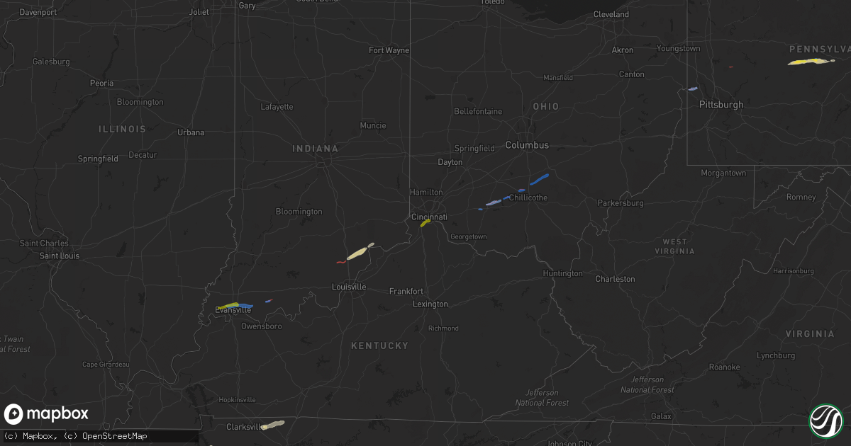
Hail Map on October 15, 2021
Get this storm
October 15 map
$229
one time, instant access
Download today. No call, no setup
Keep the $229
Bought the map and want the full workflow? Apply the entire $229 to a subscription within 7 days. None of it is wasted.
Every map, not just this one
This buys you this map. Subscription and you get every map we run, in the markets you choose from a few cities to whole states to nationwide. Plus real-time alerts the moment a storm fires.
Contact data
Name, contact info, occupancy, even credit band for addresses in the footprint. You go from where it hit to who to call.
Become the source they trust
Unlimited branding weather history reports on demand. You already have the documented answer ready for the property owner, and you are the one who showed up with it.
Property data and RoofTrace estimates
Pull up any address you have got, its value and the exact code rules for that jurisdiction, straight from One Click Code. Then RoofTrace estimates the squares, pitch, and roof value, priced the way you price.
States Impacted by Hail Map on October 15, 2021
Storm reports
Ohio
| Date | Description |
|---|---|
| 10/15/20212:42 PM CDT | Sandusky county emergency management reports damage to a home and garage on county road 268... North of vickery. Time estimated by radar. |
| 10/15/20212:42 PM CDT | This weak tornado started just about 300 feet west of n vickery road and 1200 feet north of whitmore road. This tornado moved generally from west southwest to east nort |
| 10/15/20213:58 AM CDT | A couple trees down on lower clearfork road. Time estimated based on radar. |
| 10/15/20212:51 AM CDT | Trees down |
| 10/15/20211:35 AM CDT | Several large branches downed in sugar grove. Time estimated by radar. |
| 10/15/20211:31 AM CDT | 2 trees down. Time estimated from radar. |
| 10/15/20211:15 AM CDT | Multiple trees and power poles downed. |
| 10/15/20211:10 AM CDT | House damaged on shoemaker rd |
| 10/15/202112:58 AM CDT | Roof removed from home... Along with numerous trees down from probable tornado. Time estimated from radar. |
| 10/15/202112:44 AM CDT | Numerous trees blown down. 25 acres of corn flattened. |
| 10/15/202112:29 AM CDT | Several residential structures damaged along stewart street near main street in south salem. Widespread tree damage in the area. Probable tornado. |
| 10/15/202112:05 AM CDT | Garage and shed damaged from probable tornado. Time estimated from radar. |
| 10/15/202112:04 AM CDT | Trees down from probable tornado. Time estimated from radar. |
| 10/15/202112:00 AM CDT | Trees down from probable tornado. Time estimated from radar. |
| 10/14/202110:47 PM CDT | At 347 PM EDT, a severe thunderstorm was located near Castalia, or near Port Clinton, moving northeast at 35 mph. HAZARD...60 mph wind gusts. SOURCE...Radar indicated. IMPACT...Expect damage to trees and power lines. Locations impacted include... Sandusky, Port Clinton, Kelleys Island, Put-In-Bay, Clyde, Castalia, Catawba Island, Marblehead, Bay View, Bloomingville, Sandusky South, Fairview Lanes, Whites Landing and Vickery. |
Tennessee
| Date | Description |
|---|---|
| 10/15/20212:14 AM CDT | At 713 PM CDT, a severe thunderstorm was located over Bargerton, or near Lexington, moving east at 35 mph. HAZARD...60 mph wind gusts. SOURCE...Radar indicated. IMPACT...Expect damage to roofs, siding, and trees. Locations impacted include... Lexington, Natchez Trace State Park, Natchez Trace State Forest, Parsons, Decaturville, Reagan, Blue Goose, Mifflin, Bargerton, Wildersville, Parkers Crossroads, Darden, Scotts Hill, Clarksburg, Hickory Flat, Rock Hill, Holladay, Middle Fork, Hinson Springs and Perryville. |
| 10/15/20211:43 AM CDT | At 643 PM CDT, severe thunderstorms were located along a line extending from near Fairview to Mercer, moving east at 30 mph. HAZARD...60 mph wind gusts and quarter size hail. SOURCE...Radar indicated. IMPACT...Hail damage to vehicles is expected. Expect wind damage to roofs, siding, and trees. Locations impacted include... Jackson, Lexington, Henderson, Chickasaw State Forest, Chickasaw State Park, Fairview, Three Way, Blue Goose, Mifflin, Bargerton, Bemis, Parkers Crossroads, Cloverport, Mercer, Carroll, Medina, Toone, Finger, Medon and Hickory Flat. |
| 10/15/20211:28 AM CDT | At 628 PM CDT, a severe thunderstorm was located near Hillville, or 8 miles southeast of Brownsville, moving east at 35 mph. HAZARD...60 mph wind gusts and quarter size hail. SOURCE...Radar indicated. IMPACT...Hail damage to vehicles is expected. Expect wind damage to roofs, siding, and trees. Locations impacted include... Jackson, Henderson, Chickasaw State Park, Bemis, Hillville, Cloverport, Mercer, Medon, Neely, Pinson, Huntersville, Beech Bluff, Westover, Madison Hall, Uptonville, Teague, Maple Grove, Leighton, East Union and Malesus. |
| 10/15/202112:56 AM CDT | At 556 PM CDT, a severe thunderstorm was located near Nutbush, or 8 miles west of Brownsville, moving east at 60 mph. HAZARD...60 mph wind gusts and quarter size hail. SOURCE...Radar indicated. IMPACT...Hail damage to vehicles is expected. Expect wind damage to roofs, siding, and trees. Locations impacted include... Jackson, Brownsville, Humboldt, Milan, Fairview, Alamo, Bells, Three Way, Belle Eagle, Holly Grove, Adair, Carroll, Medina, Gadsden, Allens, Huntersville, Christmasville, Westover, Jones and Shepp. |
| 10/15/202112:45 AM CDT | At 545 PM CDT, a severe thunderstorm was located near Camden, moving northeast at 35 mph. HAZARD...60 mph wind gusts and penny size hail. SOURCE...Radar indicated. IMPACT...Expect damage to roofs, siding, and trees. Locations impacted include... Waverly, Camden, Erin, New Johnsonville, McEwen and Tennessee Ridge. |
| 10/14/202111:42 PM CDT | At 441 PM CDT, a severe thunderstorm was located near Dyess, or near Keiser, moving east at 55 mph. HAZARD...60 mph wind gusts and nickel size hail. SOURCE...Radar indicated. IMPACT...Expect damage to roofs, siding, and trees. Locations impacted include... Ripley, Osceola, Luxora, Wilson, Keiser, Fort Pillow State Park, Halls, Dyess, Burdette, Marie, Fulton, Ashport, Ft Pillow, Henning, Gates, Etowah, Victoria, Edith, Eastview and O'Donnell Bend. |
Kentucky
| Date | Description |
|---|---|
| 10/15/20214:08 PM CDT | Trees down around the 2500 block of cox mill road. |
| 10/15/20214:07 PM CDT | Trees down at the 5 mile marker of princeton rd. |
| 10/15/20214:06 PM CDT | Trees down at highway 272 and petsch lane. |
| 10/15/20213:40 PM CDT | A tree fell on a power line and brought down 3 poles along martindale drive. Report from precc. |
| 10/15/20212:22 AM CDT | At 721 PM CDT, a severe thunderstorm was located over Evansville, moving east at 35 mph. HAZARD...60 mph wind gusts and penny size hail. SOURCE...Radar indicated. IMPACT...Expect damage to roofs, siding, and trees. This severe thunderstorm will be near... Melody Hill around 725 PM CDT.This includes Interstate 69 in Indiana between Mile Markers 8 and 15. |
| 10/15/20211:39 AM CDT | At 639 PM CDT, a severe thunderstorm was located near Springfield, moving northeast at 35 mph. HAZARD...60 mph wind gusts and nickel size hail. SOURCE...Radar indicated. IMPACT...Expect damage to roofs, siding, and trees. Locations impacted include... Springfield, White House, Greenbrier, Coopertown, Cross Plains, Orlinda and Cedar Hill.This includes Interstate 65 between mile markers 107 and 109. |
| 10/15/20211:07 AM CDT | At 606 PM CDT, a severe thunderstorm was located near La Center, moving east at 35 mph. HAZARD...60 mph wind gusts and penny size hail. SOURCE...Public. IMPACT...Expect damage to roofs, siding, and trees. Locations impacted include... Paducah, Metropolis, La Center, Brookport, West Paducah, Kevil, Joppa and Olmsted, and Fort Massac State Park.This includes the following highways... Interstate 24 in Kentucky between Mile Markers 1 and 5. Interstate 24 in Illinois between Mile Markers 32 and 38. |
| 10/15/202112:44 AM CDT | Numerous large trees and power lines down. |
| 10/14/202110:47 PM CDT | At 347 PM CDT, a severe thunderstorm was located over Cadiz, moving east at 35 mph. HAZARD...60 mph wind gusts and penny size hail. SOURCE...Radar indicated. IMPACT...Expect damage to roofs, siding, and trees. This severe thunderstorm will remain over mainly rural areas of central Christian and northeastern Trigg Counties.This includes the following highways... Interstate 24 in Kentucky between Mile Markers 60 and 74. Pennyrile Parkway between Mile Markers 5 and 21. |
| 10/14/202110:38 PM CDT | Several tree limbs downed along banklick rd. Time estimated by radar. |
| 10/14/202110:33 PM CDT | Numerous trees down from possible tornado. Time estimated from radar. |
| 10/14/202110:31 PM CDT | Numerous trees down from possible tornado. Time estimated from radar. |
| 10/14/202110:06 PM CDT | Tree down. Time estimated from radar. |
| 10/14/20219:49 PM CDT | At 248 PM CDT, a severe thunderstorm was located 7 miles southwest of Benton, moving east at 30 mph. HAZARD...60 mph wind gusts. SOURCE...Radar indicated. IMPACT...Expect damage to roofs, siding, and trees. This severe thunderstorm will remain over mainly rural areas of southern Marshall County, including the following locations... Aurora, Hardin and Brewers. |
| 10/14/20219:28 PM CDT | At 227 PM CDT, a severe thunderstorm was located over Mayfield, moving east at 30 mph. HAZARD...60 mph wind gusts and penny size hail. SOURCE...Radar indicated. IMPACT...Expect damage to roofs, siding, and trees. This severe thunderstorm will remain over mainly rural areas of northeastern Graves County.This includes Interstate 69 in Kentucky between Mile Markers 21 and33. |
Illinois
| Date | Description |
|---|---|
| 10/15/20215:51 PM CDT | 1 tree down over old u.s. Highway 51. |
Pennsylvania
| Date | Description |
|---|---|
| 10/15/20211:46 PM CDT | Several trees and power lines were blown down. |
| 10/15/202111:58 AM CDT | Tree down. |
| 10/15/202111:52 AM CDT | Multiple trees down from grampian to glen richey. |
| 10/15/20217:58 AM CDT | At 1258 PM EDT, a severe thunderstorm was located near Curwensville, moving east at 30 mph. HAZARD...60 mph wind gusts and quarter size hail. SOURCE...Radar indicated. IMPACT...Hail damage to vehicles is expected. Expect wind damage to roofs, siding, and trees. Locations impacted include... Clearfield, Philipsburg, Woodland, Curwensville, Hyde, Osceola Mills, Plymptonville, Chester Hill, North Philipsburg, South Philipsburg, Moshannon, Black Moshannon State Park, Jeffries, Morrisdale, West Decatur, Grassflat, Kylertown and Wallaceton.For those driving on Interstate 80, this includes areas between theClearfield and Snow Shoe exits, specifically from mile markers 120 to143.This includes Interstate 99 near mile marker 64. |
| 10/15/20217:17 AM CDT | At 1217 PM EDT, a severe thunderstorm was located 10 miles east of Punxsutawney, moving east at 25 mph. HAZARD...60 mph wind gusts and quarter size hail. SOURCE...Radar indicated. IMPACT...Hail damage to vehicles is expected. Expect wind damage to roofs, siding, and trees. Locations impacted include... Clearfield, Woodland, Curwensville, Hyde, Plymptonville, Rockton, S.B. Elliot State Park, Grampian, Wallaceton, Troutville, Lumber City and Clearfield-Lawrence Airport.For those driving on Interstate 80, this includes areas between theDubois Route 255 and Kylertown exits, specifically from mile markers110 to 125. |
| 10/15/20216:55 AM CDT | Report of damage to multiple utility poles and trees down on wires. Time estimated based on radar. |
| 10/15/20216:42 AM CDT | Report of multiple downed trees and roof damage to 2 home in monroe and millcreek townships. |
| 10/15/20216:41 AM CDT | Pictures of snapped trees and trees down on power lines along south reisburg road in monroe township. Time estimated based on radar. |
| 10/15/20216:40 AM CDT | Corrected time from 226 pm. Multiple trees reported down on divens road... Damage to a house on south reidsburg road. Time estimated based on radar. |
| 10/15/20216:04 AM CDT | Pictures show large trees snapped near the base in the chicora and keppels corner area. Time estimated based on radar. |
| 10/15/20215:53 AM CDT | Pictures of snapped trees near east butler. Time estimated based on radar |
| 10/15/20215:34 AM CDT | Large oak tree snapped and toppled maple trees on old route 68 |
| 10/15/20215:30 AM CDT | Multiple reports of tree damage in cranberry township. Time estimated based on radar. |
| 10/15/20215:20 AM CDT | Large trees uprooted. Time estimated from radar |
| 10/15/20215:19 AM CDT | Reports and pictures of damage to trees and outdoor sheds. Time estimated based on radar. |
| 10/15/20215:16 AM CDT | Ef1 tornado |
| 10/15/20215:16 AM CDT | Numerous pictures showing snapped and uprooted trees... Downed power lines... And home damage. Time estimated based on radar. |
| 10/15/20215:14 AM CDT | Report of a destroyed mobile home and several trees and limbs down. Time estimated based on radar. |
| 10/15/20215:13 AM CDT | Pictures show downed trees and telephone poles on 9th street extension in new sewickley township - possible tornado damage. Time estimated from radar. |
| 10/15/20215:12 AM CDT | Pictures show tree limbs and trunks snapped in monaca heights area. Time estimated from radar. |
| 10/15/20215:07 AM CDT | Ef0 tornado |
| 10/14/20219:43 PM CDT | At 242 PM EDT, a severe thunderstorm was located near Guys Mills, or near Meadville, moving east at 30 mph. HAZARD...60 mph wind gusts and quarter size hail. SOURCE...Radar indicated. IMPACT...Minor damage to vehicles is possible. Expect damage to trees and power lines. Locations impacted include... Titusville, Riceville, Guys Mills, Hydetown, Blooming Valley, Townville and Spartansburg. |
New York
| Date | Description |
|---|---|
| 10/15/20214:10 AM CDT | Tree down on a residence. No injuries repored at this time. Time is estimated by radar. |
| 10/15/20214:01 AM CDT | Outside industrial tent twisted. |
| 10/15/20214:00 AM CDT | Small tree down on non-residential building. |
| 10/15/20213:20 AM CDT | Tree down blocking roadway. Time estimated by radar. |
| 10/15/20211:30 AM CDT | At 630 PM EDT, a severe thunderstorm was located near Lake Erie State Park, or near Fredonia, moving northeast at 20 mph. HAZARD...60 mph wind gusts and penny size hail. SOURCE...Radar indicated. IMPACT...Expect damage to trees and power lines. Locations impacted include... Dunkirk, Fredonia, Silver Creek, Lake Erie State Park, SUNY Fredonia, Portland, Sheridan, Stockton, Brocton and Arkwright.This includes Interstate 90 near exit 59. |
| 10/15/20211:15 AM CDT | At 614 PM EDT, a severe thunderstorm was located over Darien Lakes State Park, moving east at 30 mph. HAZARD...60 mph wind gusts and quarter size hail. SOURCE...Radar indicated. IMPACT...Minor damage to vehicles is possible. Expect wind damage to trees and power lines. Locations impacted include... Batavia, Darien Lakes State Park, Marilla, Le Roy, Pembroke, Bennington, Akron, Alden, Attica and Pavilion.This includes Interstate 90 between exits 48A and 47. |
| 10/15/202112:53 AM CDT | At 552 PM EDT, a severe thunderstorm was located over Westfield, or 17 miles southwest of Fredonia, moving northeast at 25 mph. HAZARD...60 mph wind gusts and penny size hail. SOURCE...Radar indicated. IMPACT...Expect damage to trees and power lines. Locations impacted include... Dunkirk, Fredonia, Westfield, Mayville, Lake Erie State Park, SUNY Fredonia, Portland, Stockton, Brocton and Cassadaga.This includes Interstate 90 near exit 60. |
| 10/14/202111:27 PM CDT | At 427 PM EDT, a severe thunderstorm was located over Niles, or 11 miles southeast of Auburn, moving east at 25 mph. HAZARD...60 mph wind gusts and quarter size hail. SOURCE...Radar indicated. IMPACT...Hail damage to vehicles is expected. Expect wind damage to roofs, siding, and trees. Locations impacted include... Pompey, Manlius, Owasco, Otisco, Preble, Moravia, Niles, Scott, Truxton and Cuyler. |
| 10/14/202111:12 PM CDT | At 412 PM EDT, a severe thunderstorm was located near Grand Valley, moving northeast at 20 mph. HAZARD...60 mph wind gusts and penny size hail. SOURCE...Radar indicated. IMPACT...Expect damage to roofs, siding, and trees. Locations impacted include... Warren, Scandia, Warren South, Kinzua Dam, Chapman State Park, Starbrick and Clarendon. |
| 10/14/202110:45 PM CDT | At 345 PM EDT, a severe thunderstorm was located near Levanna, or 8 miles south of Seneca Falls, moving east at 25 mph. HAZARD...60 mph wind gusts and quarter size hail. SOURCE...Radar indicated. IMPACT...Hail damage to vehicles is expected. Expect wind damage to roofs, siding, and trees. Locations impacted include... Auburn, Romulus, Fayette, Owasco, Fleming, Skaneateles, Ledyard, Moravia, Union Springs and Niles. |
Arkansas
| Date | Description |
|---|---|
| 10/15/20213:25 PM CDT | Pictures of snapped and down trees near w. Republican rd and centennial rd. |
| 10/15/20213:20 PM CDT | A local report indicates a tornado near 2 SSW ROLLING HILLS |
| 10/15/20211:37 PM CDT | Social media report and picture of half dollar sized hail southwest of oppelo between arena road and the perry/conway county line. |
| 10/15/20211:00 PM CDT | A local report indicates 1.00 inch wind near OLA |
| 10/15/20217:31 AM CDT | At 1231 PM CDT, a severe thunderstorm was located near Fourche Valley, or 8 miles west of Danville, moving east at 40 mph. HAZARD...60 mph wind gusts and nickel size hail. SOURCE...Radar indicated. IMPACT...Expect damage to roofs, siding, and trees. Locations impacted include... Danville... Pottsville... Ola... Carden Bottoms... Plainview in Yell County... Petit Jean River WMA... Galla Creek WMA... Belleville... Havana... Casa... Aplin... Corinth... Birta... Nimrod... Ranger... Wing... Holla Bend... Kingston... Rover... Sunlight Bay Park... |
| 10/14/202111:46 PM CDT | At 446 PM CDT, a severe thunderstorm was located near Brinkley, moving east at 20 mph. HAZARD...60 mph wind gusts and quarter size hail. SOURCE...Radar indicated. IMPACT...Hail damage to vehicles is expected. Expect wind damage to roofs, siding, and trees. Locations impacted include... Forrest City, Wynne, Madison, Palestine, Village Creek State Park, Caldwell, Colt, Wheatley, Widener, Haynes, New Salem, Cody, Oak Forest, Slonikers Mill, Fitzgerald Crossing, Westor, New Castle, Soudan, Goodwin and McElroy. |
| 10/14/202111:25 PM CDT | At 425 PM CDT, a severe thunderstorm was located 7 miles south of Sisemore, or 7 miles south of Lonoke, moving east at 60 mph. HAZARD...60 mph wind gusts and quarter size hail. SOURCE...Radar indicated. IMPACT...Hail damage to vehicles is expected. Expect wind damage to roofs, siding, and trees. Locations impacted include... Lonoke... England... Carlisle... Humnoke... Keo... McCreanor... Brummitt... Prairie Center... Parkers Corner... Sisemore... Allport... Coy... Bevis Corner... Screeton... Toltec... Culler... Tomberlin... Pettus... Seaton... Blakemore... |
| 10/14/202110:53 PM CDT | At 353 AM CDT, severe thunderstorms were located along a line extending from 5 miles east of Fort Gibson to 3 miles northeast of Greenleaf State Park to 4 miles east of Warner, moving east at 45 mph. HAZARD...60 mph wind gusts. SOURCE...Radar indicated. IMPACT...Expect damage to roofs, siding, and trees. Locations in or near the path include... Tahlequah... Sallisaw... Stilwell... Westville... Vian... Gore... Webbers Falls... Marble City... Braggs... Brushy... Adair State Park... Christie... Greenleaf State Park... Pumpkin Center... Maryetta... Cookson... Brushy Lake State Park... Cherokee Landing State Park... Bunch... Lake Tenkiller State Park...This includes Interstate 40 in Oklahoma between mile markers 288 and299. |
| 10/14/202110:41 PM CDT | At 341 PM CDT, a severe thunderstorm was located near Sylvania, or 7 miles east of Cabot, moving east at 45 mph. HAZARD...60 mph wind gusts and quarter size hail. SOURCE...Radar indicated. IMPACT...Hail damage to vehicles is expected. Expect wind damage to roofs, siding, and trees. Locations impacted include... Cabot... Des Arc... Ward... Austin in Lonoke County... Fredonia... Barrettsville... Old Austin... Sylvania... Thurman... Parnell... Griffithville... Vinity Corner... McClelland... Gregory... Hayley... Dagmar WMA... Jasmine... Georgetown... Dixie... Sand Hill...This includes the following highways... Interstate 40 between mile markers 199 and 208. US Highway 67 between mile markers 21 and 24. |
| 10/14/202110:35 PM CDT | At 335 PM CDT, a severe thunderstorm was located over Grubbs, or 8 miles east of Newport, moving northeast at 30 mph. HAZARD...60 mph wind gusts and quarter size hail. SOURCE...Radar indicated. IMPACT...Hail damage to vehicles is expected. Expect wind damage to roofs, siding, and trees. Locations impacted include... Jonesboro, Bono, Weiner, Cash, Pitts, Hergett, Apt, Herman, Valley View, Dryden, Dorothy, Risher, Winesburg, Gilkerson, Uno, Otwell, Cary, Herndon, Bayou De View State Wildlife Management Area and Craighead Forest Park. |
| 10/14/202110:03 PM CDT | At 303 PM CDT, severe thunderstorms were located along a line extending from 6 miles southeast of Pickles Gap to near Morgan to Pinnacle Mountain State Park, mov |
| 10/14/20219:18 PM CDT | At 217 PM CDT, a severe thunderstorm was located 9 miles north of Jessieville, or 12 miles north of Hot Springs Village, moving east at 40 mph. HAZARD...60 mph wind gusts and quarter size hail. SOURCE...Radar indicated. IMPACT...Hail damage to vehicles is expected. Expect wind damage to roofs, siding, and trees. Locations impacted include... Wye Mountain... Little Italy... Williams Junction... Chenal Valley... Wye... Long Mountain... Paron... Thornburg... Pleasant Valley in Perry County... Reform... Ferndale... |
| 10/14/20218:58 PM CDT | At 158 PM CDT, a severe thunderstorm was located near Conway, moving east at 35 mph. HAZARD...Ping pong ball size hail and 60 mph wind gusts. SOURCE...Radar indicated. IMPACT...People and animals outdoors will be injured. Expect hail damage to roofs, siding, windows, and vehicles. Expect wind damage to roofs, siding, and trees. Locations impacted include... Conway... Greenbrier... Vilonia... Mayflower... Wooster... Enola... Menifee... Mount Vernon... Pickles Gap... Springhill... Toad Suck... Plumerville... Holland... Bigelow... Fourche... Hamlet... Saltillo... Otto... New Dixie... This includes Interstate 40 between mile markers 112 and 134. |
| 10/14/20218:30 PM CDT | At 129 PM CDT, a severe thunderstorm was located near Muddy Creek WMA, or 17 miles north of Mount Ida, moving east at 50 mph. HAZARD...60 mph wind gusts and quarter size hail. SOURCE...Radar indicated. IMPACT...Hail damage to vehicles is expected. Expect wind damage to roofs, siding, and trees. Locations impacted include... Hot Springs Village... Jessieville... Carter Cove Park... Chula... Mt Tabor... Fannie... Hamilton... Fourche Junction... Hollis... Onyx... Fourche Mountain Recreation Are... Story... Sunlight Bay Park... Garden Point Recreation Area... Nimrod... |
| 10/14/20218:11 PM CDT | At 110 PM CDT, a severe thunderstorm was located near Carden Bottoms, or 12 miles northwest of Perryville, moving east at 40 mph. HAZARD...60 mph wind gusts and half dollar size hail. SOURCE...Radar indicated. IMPACT...Hail damage to vehicles is expected. Expect wind damage to roofs, siding, and trees. Locations impacted include... Conway... Morrilton... Perryville... Atkins... Wooster... Oppelo... Menifee... Perry... Adona... Houston... Bethlehem... Sequoya Park... Hill Creek... Carden Bottoms... Solgohachia... Petit Jean State Park... Mallet Town... Galla Creek WMA... Toad Suck... Springfield...This includes Interstate 40 between mile markers 99 and 130. |
Mississippi
| Date | Description |
|---|---|
| 10/15/20212:09 AM CDT | At 709 PM CDT, a severe thunderstorm was located over Independence, or 13 miles east of Senatobia, moving east at 35 mph. HAZARD...60 mph wind gusts. SOURCE...Radar indicated. IMPACT...Expect damage to roofs, siding, and trees. Locations impacted include... Holly Springs, Wall Doxey State Park, Barr, Bethlehem, Independence, Laws Hill, Marianna, Potts Camp, Malone, Wakefield, Waterford, Aiken, Higdon, Crossroad, Tyro, Watson, Gilton, Chulahoma, Lake Center and Galena. |
| 10/15/20211:21 AM CDT | At 621 PM CDT, a severe thunderstorm was located near Eudora, or 12 miles west of Hernando, moving east at 35 mph. HAZARD...60 mph wind gusts and penny size hail. SOURCE...Radar indicated. IMPACT...Expect damage to roofs, siding, and trees. Locations impacted include... Southaven, Olive Branch, Horn Lake, Hernando, Lake Cormorant, Phillipp, Eudora, Lewisburg, Wakefield, Newport, Clack, Trinity, Cockrum, Frees Corners, Cedarview, Bright, Nesbit, Handy Corner, Glover and Banks. |
| 10/15/202112:31 AM CDT | At 531 PM CDT, a severe thunderstorm was located over Haynes, or near Forrest City, moving east at 45 mph. HAZARD...60 mph wind gusts and quarter size hail. SOURCE...Radar indicated. IMPACT...Hail damage to vehicles is expected. Expect wind damage to roofs, siding, and trees. Locations impacted include... Southaven, Horn Lake, Forrest City, Marianna, Hughes, Madison, Walls, Horseshoe Lake, Widener, Haynes, Lake Cormorant, Eudora, Brickeys, Arkabutla, Pinckney, Lynchburg, Phillipp, Robinsonville, Cody and Clack. |
Indiana
| Date | Description |
|---|---|
| 10/15/20212:35 AM CDT | At 735 PM CDT, a severe thunderstorm was located near Melody Hill, moving east at 40 mph. HAZARD...60 mph wind gusts and penny size hail. SOURCE...Radar indicated. IMPACT...Expect damage to roofs, siding, and trees. This severe thunderstorm will be near... Chandler around 740 PM CDT. Boonville around 750 PM CDT.This includes Interstate 69 in Indiana near Mile Marker 7. |
| 10/14/20219:41 PM CDT | A tree fell across a vehicle in lexington... In. |
| 10/14/20219:41 PM CDT | 15 to 20 trees reported down on poplar street. |
| 10/14/20219:40 PM CDT | Brief ef0 tornado with peak winds of 80 mph. It was on the ground for 0.6 miles with a path width peaking at 75 yards. |
| 10/14/20219:16 PM CDT | Report of wires and tree branches down on a house along the 8000 block of e lakeside dr. |
| 10/14/20219:15 PM CDT | Very brief ef0 tornado touchdown with peak winds of 70-75 mph. On the ground only for 0.1 miles with a width of 60-70 yards. |
| 10/14/20218:10 PM CDT | Trees down in the area of hwy 62 and county road 1250. Electrical lines down in the area as well. |
| 10/14/20218:10 PM CDT | Path length 1.1 miles. Several trees were snapped in the location of county road 1250n and the railroad tracks... About 1 mile west of hwy 231. The tornado tracked abou |
| 10/14/20217:22 PM CDT | Large tree on a house and electrical wires down. |
Oklahoma
| Date | Description |
|---|---|
| 10/15/20217:54 AM CDT | At 1254 AM CDT, a severe thunderstorm was located near Harrah, moving east at 35 mph. HAZARD...60 mph wind gusts and quarter size hail. SOURCE...Radar indicated. IMPACT...Hail damage to vehicles is expected. Expect wind damage to roofs, siding, and trees. Locations impacted include... Eastern Oklahoma City, Shawnee, Choctaw, Harrah, McLoud, Prague, Meeker, Johnson, Sparks, Newalla and Aydelotte. |
| 10/15/20217:12 AM CDT | At 1212 AM CDT, a severe thunderstorm was located over southwestern Oklahoma City, or near Will Rogers Airport, moving east at 30 mph. HAZARD...70 mph wind gusts and ping pong ball size hail. SOURCE...Radar indicated. IMPACT...People and animals outdoors will be injured. Expect hail damage to roofs, siding, windows, and vehicles. Expect considerable tree damage. Wind damage is also likely to mobile homes, roofs, and outbuildings. Locations impacted include... Oklahoma City, Moore, Midwest City, Del City, Newcastle, Bethany, Choctaw, Warr Acres, Harrah, Spencer, Nichols Hills, Jones, Nicoma Park, Luther, Valley Brook, Tinker Air Force Base, Stanley Draper Lake, Newalla, Forest Park and Woodlawn Park. |
| 10/14/202110:29 PM CDT | At 329 AM CDT, severe thunderstorms were located along a line extending from 2 miles southeast of Taft to Oktaha to 4 miles north of Raiford, moving east at 45 mph. HAZARD...60 mph wind gusts. SOURCE...Trained weather spotters. IMPACT...Expect damage to roofs, siding, and trees. Locations in or near the path include... Muskogee... Tahlequah... Fort Gibson... Checotah... Warner... Porum... Webbers Falls... Oktaha... Braggs... Taft... Council Hill... Rentiesville... Stidham... Greenleaf State Park... Pumpkin Center... Vivian... Lake Eufaula State Park... Keefeton... Wainwright... Summit...This includes Interstate 40 in Oklahoma between mile markers 252 and288. |
| 10/14/20219:51 PM CDT | At 251 AM CDT, severe thunderstorms were located along a line extending from near Okmulgee State Park to Schulter to 3 miles southwest of Weleetka, moving east at 45 mph. HAZARD...60 mph wind gusts and half dollar size hail. SOURCE...Radar indicated. IMPACT...Hail damage to vehicles is expected. Expect wind damage to roofs, siding, and trees. Locations in or near the path include... Muskogee... Fort Gibson... Checotah... Warner... Morris... Dewar... Oktaha... Boynton... Grayson... Council Hill... Rentiesville... Hoffman... Stidham... Lake Eufaula State Park... Keefeton... Wainwright... Summit... Hitchita... Pierce... Eram...This includes Interstate 40 in Oklahoma between mile markers 239 and278. |
| 10/14/20219:26 PM CDT | At 226 AM CDT, severe thunderstorms were located along a line extending from Welty to 2 miles west of Okemah to 5 miles southwest of Cromwell, moving east at 35 mph. HAZARD...60 mph wind gusts and quarter size hail. SOURCE...Radar indicated. IMPACT...Hail damage to vehicles is expected. Expect wind damage to roofs, siding, and trees. Locations in or near the path include... Okmulgee... Okemah... Okfuskee... Henryetta... Boley... Weleetka... Schulter... Bearden... Castle... Clearview... Okmulgee State Park... Welty... Pharoah... Bryant... Mason... This includes Interstate 40 in Oklahoma between mile markers 212 and239. |
| 10/14/20218:41 PM CDT | At 141 AM CDT, severe thunderstorms were located along a line extending from 6 miles southeast of Sparks to Prague to 2 miles south of Johnson, moving east at 30 mph. HAZARD...60 mph wind gusts and half dollar size hail. SOURCE...Radar indicated. IMPACT...Hail damage to vehicles is expected. Expect wind damage to roofs, siding, and trees. Locations in or near the path include... Okemah... Okfuskee... Boley... Weleetka... Paden... Bearden... Castle... Clearview... Welty... Mason...This includes Interstate 40 in Oklahoma between mile markers 212 and229. |
| 10/14/20218:39 PM CDT | At 138 AM CDT, severe thunderstorms were located along a line extending from 3 miles west of Prague to near Tecumseh to near Etowah, moving east at 40 mph. HAZARD...60 mph wind gusts and quarter size hail. SOURCE...Radar indicated. IMPACT...Hail damage to vehicles is expected. Expect wind damage to roofs, siding, and trees. Locations impacted include... Southeastern Norman, Shawnee, Seminole, Tecumseh, Prague, Pink, Meeker, Maud, Earlsboro, Bowlegs, Tribbey, Cromwell, Johnson, Etowah, Brooksville, Macomb, Little, Bethel Acres, Lima and Aydelotte. |
Cities Impacted by Hail Map on October 15, 2021
- Ripley, TN
- Brownsville, TN
- Clearfield, PA
- Curwensville, PA
- Palestine, AR
- Cotton Plant, AR
- Des Arc, AR
- Wilson, AR
- Osceola, AR
- Adona, AR
- Perry, AR
- Houston, AR
- Morrilton, AR
- Sharon, TN
- Newbern, TN
- Kenton, TN
- Dyer, TN
- Rutherford, TN
- Greenfield, TN
- Big Sandy, TN
- Springville, TN
- Bells, TN
- Cabot, AR
- Hanover, IN
- Lexington, IN
- Underwood, IN
- Scottsburg, IN
- Newport, AR
- Plainview, AR
- Paron, AR
- Casa, AR
- Dardanelle, AR
- Bigelow, AR
- Conway, AR
- Scott, AR
- Morrisdale, PA
- West Decatur, PA
- Wallaceton, PA
- Waverly, TN
- McEwen, TN
- Evansville, IN
- Lepanto, AR
- Joiner, AR
- Marked Tree, AR
- Dyess, AR
- Etowah, AR
- Keiser, AR
- Mahaffey, PA
- Lonoke, AR
- Austin, AR
- Jacksonville, AR
- Ward, AR
- Coldwater, MS
- Senatobia, MS
- Holly Springs, MS
- Robinsonville, MS
- Amagon, AR
- Cash, AR
- Nabb, IN
- Henryville, IN
- Perryville, AR
- Philipsburg, PA
- Benton, IL
- Sesser, IL
- Whittington, IL
- Ewing, IL
- Ola, AR
- Danville, AR
- Jackson, TN
- Humboldt, TN
- Cedar Hill, TN
- Adams, TN
- Grampian, PA
- Olanta, PA
- Punxsutawney, PA
- Glen Richey, PA
- Madison, IN
- Marysville, IN
- Trumann, AR
- Bay, AR
- Wheatley, AR
- Brinkley, AR
- Belleville, AR
- Plumerville, AR
- Springfield, TN
- Cross Plains, TN
- England, AR
- Little Rock, AR
- Covington, TN
- Mayflower, AR
- Roland, AR
- Rossiter, PA
- Gadsden, TN
- Alamo, TN
- Forrest City, AR
- Goodwin, AR
- Henning, TN
- Mount Vernon, IN
- Monaca, PA
- Industry, PA
- Hookstown, PA
- Aliquippa, PA
- Midland, PA
- Georgetown, PA
- Shippingport, PA
- Butler, PA
- East Butler, PA
- Westfield, NY
- Mayville, NY
- Dewittville, NY
- Stockton, NY
- Sherman, NY
- Ripley, NY
- King Ferry, NY
- Interlaken, NY
- Lodi, NY
- Boonville, IN
- Chandler, IN
- Newburgh, IN
- Chrisney, IN
- Lamar, IN
- Gentryville, IN
- Pekin, IN
- Rover, AR
- Hickory Plains, AR
- Carlisle, AR
- Lynchburg, OH
- Hillsboro, OH
- Leesburg, OH
- Greenfield, OH
- South Salem, OH
- Chillicothe, OH
- Frankfort, OH
- Laurelville, OH
- Kingston, OH
- Circleville, OH
- Stoutsville, OH
- Amanda, OH
- Lancaster, OH
- Tarlton, OH
- Covington, KY
- Florence, KY
- Latonia, KY
- Ft Mitchell, KY
- Erlanger, KY