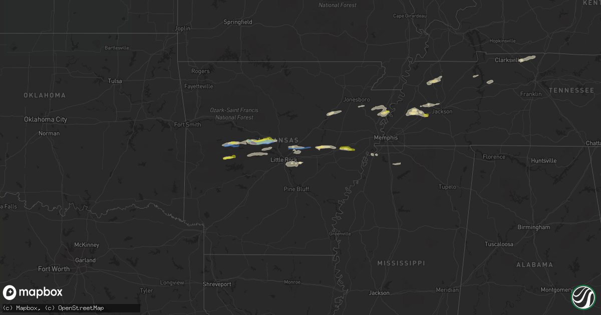
Hail Map in Arkansas on October 15, 2021
Get this storm
October 15 map
$229
one time, instant access
Download today. No call, no setup
Keep the $229
Bought the map and want the full workflow? Apply the entire $229 to a subscription within 7 days. None of it is wasted.
Every map, not just this one
This buys you this map. Subscription and you get every map we run, in the markets you choose from a few cities to whole states to nationwide. Plus real-time alerts the moment a storm fires.
Contact data
Name, contact info, occupancy, even credit band for addresses in the footprint. You go from where it hit to who to call.
Become the source they trust
Unlimited branding weather history reports on demand. You already have the documented answer ready for the property owner, and you are the one who showed up with it.
Property data and RoofTrace estimates
Pull up any address you have got, its value and the exact code rules for that jurisdiction, straight from One Click Code. Then RoofTrace estimates the squares, pitch, and roof value, priced the way you price.
Storm reports in Arkansas
Arkansas
| Date | Description |
|---|---|
| 10/15/20213:25 PM CDT | Pictures of snapped and down trees near w. Republican rd and centennial rd. |
| 10/15/20213:20 PM CDT | A local report indicates a tornado near 2 SSW ROLLING HILLS |
| 10/15/20211:37 PM CDT | Social media report and picture of half dollar sized hail southwest of oppelo between arena road and the perry/conway county line. |
| 10/15/20211:00 PM CDT | A local report indicates 1.00 inch wind near OLA |
| 10/15/20217:31 AM CDT | At 1231 PM CDT, a severe thunderstorm was located near Fourche Valley, or 8 miles west of Danville, moving east at 40 mph. HAZARD...60 mph wind gusts and nickel size hail. SOURCE...Radar indicated. IMPACT...Expect damage to roofs, siding, and trees. Locations impacted include... Danville... Pottsville... Ola... Carden Bottoms... Plainview in Yell County... Petit Jean River WMA... Galla Creek WMA... Belleville... Havana... Casa... Aplin... Corinth... Birta... Nimrod... Ranger... Wing... Holla Bend... Kingston... Rover... Sunlight Bay Park... |
| 10/14/202111:46 PM CDT | At 446 PM CDT, a severe thunderstorm was located near Brinkley, moving east at 20 mph. HAZARD...60 mph wind gusts and quarter size hail. SOURCE...Radar indicated. IMPACT...Hail damage to vehicles is expected. Expect wind damage to roofs, siding, and trees. Locations impacted include... Forrest City, Wynne, Madison, Palestine, Village Creek State Park, Caldwell, Colt, Wheatley, Widener, Haynes, New Salem, Cody, Oak Forest, Slonikers Mill, Fitzgerald Crossing, Westor, New Castle, Soudan, Goodwin and McElroy. |
| 10/14/202111:25 PM CDT | At 425 PM CDT, a severe thunderstorm was located 7 miles south of Sisemore, or 7 miles south of Lonoke, moving east at 60 mph. HAZARD...60 mph wind gusts and quarter size hail. SOURCE...Radar indicated. IMPACT...Hail damage to vehicles is expected. Expect wind damage to roofs, siding, and trees. Locations impacted include... Lonoke... England... Carlisle... Humnoke... Keo... McCreanor... Brummitt... Prairie Center... Parkers Corner... Sisemore... Allport... Coy... Bevis Corner... Screeton... Toltec... Culler... Tomberlin... Pettus... Seaton... Blakemore... |
| 10/14/202110:53 PM CDT | At 353 AM CDT, severe thunderstorms were located along a line extending from 5 miles east of Fort Gibson to 3 miles northeast of Greenleaf State Park to 4 miles east of Warner, moving east at 45 mph. HAZARD...60 mph wind gusts. SOURCE...Radar indicated. IMPACT...Expect damage to roofs, siding, and trees. Locations in or near the path include... Tahlequah... Sallisaw... Stilwell... Westville... Vian... Gore... Webbers Falls... Marble City... Braggs... Brushy... Adair State Park... Christie... Greenleaf State Park... Pumpkin Center... Maryetta... Cookson... Brushy Lake State Park... Cherokee Landing State Park... Bunch... Lake Tenkiller State Park...This includes Interstate 40 in Oklahoma between mile markers 288 and299. |
| 10/14/202110:41 PM CDT | At 341 PM CDT, a severe thunderstorm was located near Sylvania, or 7 miles east of Cabot, moving east at 45 mph. HAZARD...60 mph wind gusts and quarter size hail. SOURCE...Radar indicated. IMPACT...Hail damage to vehicles is expected. Expect wind damage to roofs, siding, and trees. Locations impacted include... Cabot... Des Arc... Ward... Austin in Lonoke County... Fredonia... Barrettsville... Old Austin... Sylvania... Thurman... Parnell... Griffithville... Vinity Corner... McClelland... Gregory... Hayley... Dagmar WMA... Jasmine... Georgetown... Dixie... Sand Hill...This includes the following highways... Interstate 40 between mile markers 199 and 208. US Highway 67 between mile markers 21 and 24. |
| 10/14/202110:35 PM CDT | At 335 PM CDT, a severe thunderstorm was located over Grubbs, or 8 miles east of Newport, moving northeast at 30 mph. HAZARD...60 mph wind gusts and quarter size hail. SOURCE...Radar indicated. IMPACT...Hail damage to vehicles is expected. Expect wind damage to roofs, siding, and trees. Locations impacted include... Jonesboro, Bono, Weiner, Cash, Pitts, Hergett, Apt, Herman, Valley View, Dryden, Dorothy, Risher, Winesburg, Gilkerson, Uno, Otwell, Cary, Herndon, Bayou De View State Wildlife Management Area and Craighead Forest Park. |
| 10/14/202110:03 PM CDT | At 303 PM CDT, severe thunderstorms were located along a line extending from 6 miles southeast of Pickles Gap to near Morgan to Pinnacle Mountain State Park, mov |
| 10/14/20219:18 PM CDT | At 217 PM CDT, a severe thunderstorm was located 9 miles north of Jessieville, or 12 miles north of Hot Springs Village, moving east at 40 mph. HAZARD...60 mph wind gusts and quarter size hail. SOURCE...Radar indicated. IMPACT...Hail damage to vehicles is expected. Expect wind damage to roofs, siding, and trees. Locations impacted include... Wye Mountain... Little Italy... Williams Junction... Chenal Valley... Wye... Long Mountain... Paron... Thornburg... Pleasant Valley in Perry County... Reform... Ferndale... |
| 10/14/20218:58 PM CDT | At 158 PM CDT, a severe thunderstorm was located near Conway, moving east at 35 mph. HAZARD...Ping pong ball size hail and 60 mph wind gusts. SOURCE...Radar indicated. IMPACT...People and animals outdoors will be injured. Expect hail damage to roofs, siding, windows, and vehicles. Expect wind damage to roofs, siding, and trees. Locations impacted include... Conway... Greenbrier... Vilonia... Mayflower... Wooster... Enola... Menifee... Mount Vernon... Pickles Gap... Springhill... Toad Suck... Plumerville... Holland... Bigelow... Fourche... Hamlet... Saltillo... Otto... New Dixie... This includes Interstate 40 between mile markers 112 and 134. |
| 10/14/20218:30 PM CDT | At 129 PM CDT, a severe thunderstorm was located near Muddy Creek WMA, or 17 miles north of Mount Ida, moving east at 50 mph. HAZARD...60 mph wind gusts and quarter size hail. SOURCE...Radar indicated. IMPACT...Hail damage to vehicles is expected. Expect wind damage to roofs, siding, and trees. Locations impacted include... Hot Springs Village... Jessieville... Carter Cove Park... Chula... Mt Tabor... Fannie... Hamilton... Fourche Junction... Hollis... Onyx... Fourche Mountain Recreation Are... Story... Sunlight Bay Park... Garden Point Recreation Area... Nimrod... |
| 10/14/20218:11 PM CDT | At 110 PM CDT, a severe thunderstorm was located near Carden Bottoms, or 12 miles northwest of Perryville, moving east at 40 mph. HAZARD...60 mph wind gusts and half dollar size hail. SOURCE...Radar indicated. IMPACT...Hail damage to vehicles is expected. Expect wind damage to roofs, siding, and trees. Locations impacted include... Conway... Morrilton... Perryville... Atkins... Wooster... Oppelo... Menifee... Perry... Adona... Houston... Bethlehem... Sequoya Park... Hill Creek... Carden Bottoms... Solgohachia... Petit Jean State Park... Mallet Town... Galla Creek WMA... Toad Suck... Springfield...This includes Interstate 40 between mile markers 99 and 130. |
All States Impacted by Hail Map on October 15, 2021
Cities Impacted by Hail Map on October 15, 2021
- Ripley, TN
- Brownsville, TN
- Clearfield, PA
- Curwensville, PA
- Palestine, AR
- Cotton Plant, AR
- Des Arc, AR
- Wilson, AR
- Osceola, AR
- Adona, AR
- Perry, AR
- Houston, AR
- Morrilton, AR
- Sharon, TN
- Newbern, TN
- Kenton, TN
- Dyer, TN
- Rutherford, TN
- Greenfield, TN
- Big Sandy, TN
- Springville, TN
- Bells, TN
- Cabot, AR
- Hanover, IN
- Lexington, IN
- Underwood, IN
- Scottsburg, IN
- Newport, AR
- Plainview, AR
- Paron, AR
- Casa, AR
- Dardanelle, AR
- Bigelow, AR
- Conway, AR
- Scott, AR
- Morrisdale, PA
- West Decatur, PA
- Wallaceton, PA
- Waverly, TN
- McEwen, TN
- Evansville, IN
- Lepanto, AR
- Joiner, AR
- Marked Tree, AR
- Dyess, AR
- Etowah, AR
- Keiser, AR
- Mahaffey, PA
- Lonoke, AR
- Austin, AR
- Jacksonville, AR
- Ward, AR
- Coldwater, MS
- Senatobia, MS
- Holly Springs, MS
- Robinsonville, MS
- Amagon, AR
- Cash, AR
- Nabb, IN
- Henryville, IN
- Perryville, AR
- Philipsburg, PA
- Benton, IL
- Sesser, IL
- Whittington, IL
- Ewing, IL
- Ola, AR
- Danville, AR
- Jackson, TN
- Humboldt, TN
- Cedar Hill, TN
- Adams, TN
- Grampian, PA
- Olanta, PA
- Punxsutawney, PA
- Glen Richey, PA
- Madison, IN
- Marysville, IN
- Trumann, AR
- Bay, AR
- Wheatley, AR
- Brinkley, AR
- Belleville, AR
- Plumerville, AR
- Springfield, TN
- Cross Plains, TN
- England, AR
- Little Rock, AR
- Covington, TN
- Mayflower, AR
- Roland, AR
- Rossiter, PA
- Gadsden, TN
- Alamo, TN
- Forrest City, AR
- Goodwin, AR
- Henning, TN
- Mount Vernon, IN
- Monaca, PA
- Industry, PA
- Hookstown, PA
- Aliquippa, PA
- Midland, PA
- Georgetown, PA
- Shippingport, PA
- Butler, PA
- East Butler, PA
- Westfield, NY
- Mayville, NY
- Dewittville, NY
- Stockton, NY
- Sherman, NY
- Ripley, NY
- King Ferry, NY
- Interlaken, NY
- Lodi, NY
- Boonville, IN
- Chandler, IN
- Newburgh, IN
- Chrisney, IN
- Lamar, IN
- Gentryville, IN
- Pekin, IN
- Rover, AR
- Hickory Plains, AR
- Carlisle, AR
- Lynchburg, OH
- Hillsboro, OH
- Leesburg, OH
- Greenfield, OH
- South Salem, OH
- Chillicothe, OH
- Frankfort, OH
- Laurelville, OH
- Kingston, OH
- Circleville, OH
- Stoutsville, OH
- Amanda, OH
- Lancaster, OH
- Tarlton, OH
- Covington, KY
- Florence, KY
- Latonia, KY
- Ft Mitchell, KY
- Erlanger, KY


