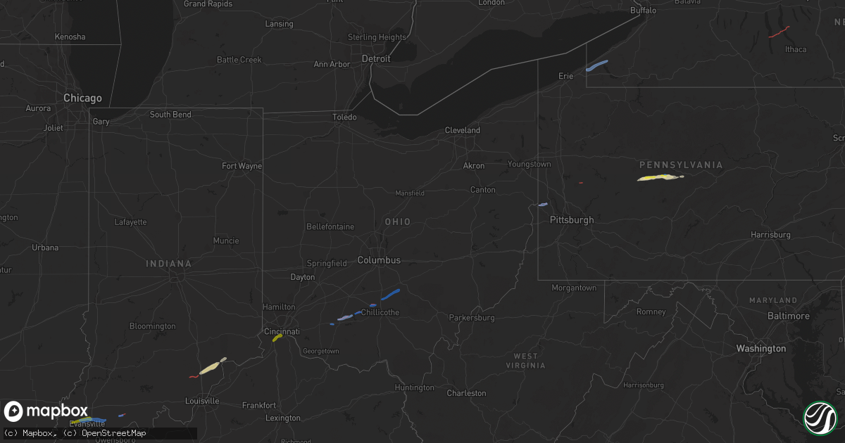
Hail Map in Ohio on October 15, 2021
Get this storm
October 15 map
$229
one time, instant access
Download today. No call, no setup
Keep the $229
Bought the map and want the full workflow? Apply the entire $229 to a subscription within 7 days. None of it is wasted.
Every map, not just this one
This buys you this map. Subscription and you get every map we run, in the markets you choose from a few cities to whole states to nationwide. Plus real-time alerts the moment a storm fires.
Contact data
Name, contact info, occupancy, even credit band for addresses in the footprint. You go from where it hit to who to call.
Become the source they trust
Unlimited branding weather history reports on demand. You already have the documented answer ready for the property owner, and you are the one who showed up with it.
Property data and RoofTrace estimates
Pull up any address you have got, its value and the exact code rules for that jurisdiction, straight from One Click Code. Then RoofTrace estimates the squares, pitch, and roof value, priced the way you price.
Storm reports in Ohio
Ohio
| Date | Description |
|---|---|
| 10/15/20212:42 PM CDT | Sandusky county emergency management reports damage to a home and garage on county road 268... North of vickery. Time estimated by radar. |
| 10/15/20212:42 PM CDT | This weak tornado started just about 300 feet west of n vickery road and 1200 feet north of whitmore road. This tornado moved generally from west southwest to east nort |
| 10/15/20213:58 AM CDT | A couple trees down on lower clearfork road. Time estimated based on radar. |
| 10/15/20212:51 AM CDT | Trees down |
| 10/15/20211:35 AM CDT | Several large branches downed in sugar grove. Time estimated by radar. |
| 10/15/20211:31 AM CDT | 2 trees down. Time estimated from radar. |
| 10/15/20211:15 AM CDT | Multiple trees and power poles downed. |
| 10/15/20211:10 AM CDT | House damaged on shoemaker rd |
| 10/15/202112:58 AM CDT | Roof removed from home... Along with numerous trees down from probable tornado. Time estimated from radar. |
| 10/15/202112:44 AM CDT | Numerous trees blown down. 25 acres of corn flattened. |
| 10/15/202112:29 AM CDT | Several residential structures damaged along stewart street near main street in south salem. Widespread tree damage in the area. Probable tornado. |
| 10/15/202112:05 AM CDT | Garage and shed damaged from probable tornado. Time estimated from radar. |
| 10/15/202112:04 AM CDT | Trees down from probable tornado. Time estimated from radar. |
| 10/15/202112:00 AM CDT | Trees down from probable tornado. Time estimated from radar. |
| 10/14/202110:47 PM CDT | At 347 PM EDT, a severe thunderstorm was located near Castalia, or near Port Clinton, moving northeast at 35 mph. HAZARD...60 mph wind gusts. SOURCE...Radar indicated. IMPACT...Expect damage to trees and power lines. Locations impacted include... Sandusky, Port Clinton, Kelleys Island, Put-In-Bay, Clyde, Castalia, Catawba Island, Marblehead, Bay View, Bloomingville, Sandusky South, Fairview Lanes, Whites Landing and Vickery. |
All States Impacted by Hail Map on October 15, 2021
Cities Impacted by Hail Map on October 15, 2021
- Ripley, TN
- Brownsville, TN
- Clearfield, PA
- Curwensville, PA
- Palestine, AR
- Cotton Plant, AR
- Des Arc, AR
- Wilson, AR
- Osceola, AR
- Adona, AR
- Perry, AR
- Houston, AR
- Morrilton, AR
- Sharon, TN
- Newbern, TN
- Kenton, TN
- Dyer, TN
- Rutherford, TN
- Greenfield, TN
- Big Sandy, TN
- Springville, TN
- Bells, TN
- Cabot, AR
- Hanover, IN
- Lexington, IN
- Underwood, IN
- Scottsburg, IN
- Newport, AR
- Plainview, AR
- Paron, AR
- Casa, AR
- Dardanelle, AR
- Bigelow, AR
- Conway, AR
- Scott, AR
- Morrisdale, PA
- West Decatur, PA
- Wallaceton, PA
- Waverly, TN
- McEwen, TN
- Evansville, IN
- Lepanto, AR
- Joiner, AR
- Marked Tree, AR
- Dyess, AR
- Etowah, AR
- Keiser, AR
- Mahaffey, PA
- Lonoke, AR
- Austin, AR
- Jacksonville, AR
- Ward, AR
- Coldwater, MS
- Senatobia, MS
- Holly Springs, MS
- Robinsonville, MS
- Amagon, AR
- Cash, AR
- Nabb, IN
- Henryville, IN
- Perryville, AR
- Philipsburg, PA
- Benton, IL
- Sesser, IL
- Whittington, IL
- Ewing, IL
- Ola, AR
- Danville, AR
- Jackson, TN
- Humboldt, TN
- Cedar Hill, TN
- Adams, TN
- Grampian, PA
- Olanta, PA
- Punxsutawney, PA
- Glen Richey, PA
- Madison, IN
- Marysville, IN
- Trumann, AR
- Bay, AR
- Wheatley, AR
- Brinkley, AR
- Belleville, AR
- Plumerville, AR
- Springfield, TN
- Cross Plains, TN
- England, AR
- Little Rock, AR
- Covington, TN
- Mayflower, AR
- Roland, AR
- Rossiter, PA
- Gadsden, TN
- Alamo, TN
- Forrest City, AR
- Goodwin, AR
- Henning, TN
- Mount Vernon, IN
- Monaca, PA
- Industry, PA
- Hookstown, PA
- Aliquippa, PA
- Midland, PA
- Georgetown, PA
- Shippingport, PA
- Butler, PA
- East Butler, PA
- Westfield, NY
- Mayville, NY
- Dewittville, NY
- Stockton, NY
- Sherman, NY
- Ripley, NY
- King Ferry, NY
- Interlaken, NY
- Lodi, NY
- Boonville, IN
- Chandler, IN
- Newburgh, IN
- Chrisney, IN
- Lamar, IN
- Gentryville, IN
- Pekin, IN
- Rover, AR
- Hickory Plains, AR
- Carlisle, AR
- Lynchburg, OH
- Hillsboro, OH
- Leesburg, OH
- Greenfield, OH
- South Salem, OH
- Chillicothe, OH
- Frankfort, OH
- Laurelville, OH
- Kingston, OH
- Circleville, OH
- Stoutsville, OH
- Amanda, OH
- Lancaster, OH
- Tarlton, OH
- Covington, KY
- Florence, KY
- Latonia, KY
- Ft Mitchell, KY
- Erlanger, KY


