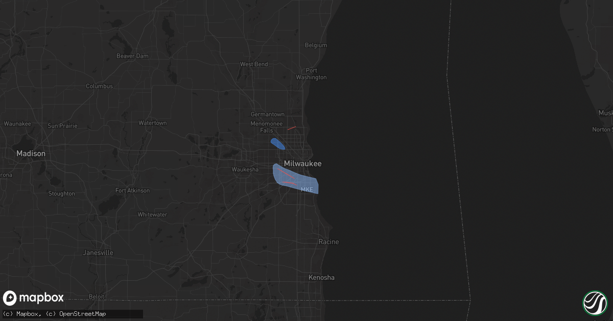
Hail Map in Milwaukee, WI on October 12, 2022
Get this storm
October 12 map
$229
one time, instant access
Download today. No call, no setup
Keep the $229
Bought the map and want the full workflow? Apply the entire $229 to a subscription within 7 days. None of it is wasted.
Every map, not just this one
This buys you this map. Subscription and you get every map we run, in the markets you choose from a few cities to whole states to nationwide. Plus real-time alerts the moment a storm fires.
Contact data
Name, contact info, occupancy, even credit band for addresses in the footprint. You go from where it hit to who to call.
Become the source they trust
Unlimited branding weather history reports on demand. You already have the documented answer ready for the property owner, and you are the one who showed up with it.
Property data and RoofTrace estimates
Pull up any address you have got, its value and the exact code rules for that jurisdiction, straight from One Click Code. Then RoofTrace estimates the squares, pitch, and roof value, priced the way you price.
Storm reports in Milwaukee, WI
Milwaukee, WI
| Date | Description |
|---|---|
| 10/12/20221:00 PM CDT | Large limbs down. Time estimated from radar. |
| 10/12/202212:52 PM CDT | Report from mping: 1-inch tree limbs broken; shingles blown off. |
| 10/12/202212:46 PM CDT | Trees downed 68th & harrison and 65th & cleveland ave milwaukee/west allis border. |
| 10/12/202212:40 PM CDT | Tree branches down along e bolivar ave along with some yard decorations damaged. |
| 10/12/202212:34 PM CDT | Peak gust at mitchell international. |
| 10/12/202212:30 PM CDT | 3 inch diameter tree limbs snapped at 2nd street and plainfield avenue. Time estimated from radar. |
| 10/12/202212:30 PM CDT | A local report indicates a tornado near BROWN DEER |
| 10/12/202212:26 PM CDT | Report from mping: 3-inch tree limbs broken; power poles broken. Estimated 50-60 mph. |
| 10/12/202212:24 PM CDT | Large trees down on hayes avenue between 72nd and 74th streets. Power lines down on 72nd street between hayes avenue and beloit road. Time estimated from radar. |
| 10/12/202212:19 PM CDT | Peak winds around 75 mph... Ended around s 58th st between w stack dr and s 57th st. Lasted less than 10 minutes. Path length about 3 miles. |
All States Impacted by Hail Map on October 12, 2022
All Cities Impacted by Hail Map on October 12, 2022
- Judsonia, AR
- Jay, OK
- Jackson, TN
- Ponca, AR
- Parthenon, AR
- Saltillo, TN
- Morris Chapel, TN
- Savannah, TN
- Collinwood, TN
- Lutts, TN
- Olivehill, TN
- Gentry, AR
- Siloam Springs, AR
- Albany, KY
- Alpha, KY
- Burkesville, KY
- Monticello, KY
- Ozark, AR
- Nixa, MO
- Clever, MO
- Billings, MO
- Belden, MS
- Tupelo, MS
- Pontotoc, MS
- Delaplaine, AR
- Hamburg, AR
- Jacksonville, AR
- Pineville, MO
- Anderson, MO
- Vaiden, MS
- Columbus, MS
- Cabot, AR
- Hazlehurst, MS
- Crystal Springs, MS
- Salina, OK
- Saint Paul, AR
- Witter, AR
- Pettigrew, AR
- Cleveland, AR
- Somerville, TN
- South West City, MO
- Afton, OK
- Grove, OK
- Rogersville, MO
- Strafford, MO
- Springfield, MO
- Clinton, AR
- Scotland, AR
- Fort Gay, WV
- Lowmansville, KY
- Crum, WV
- Wittensville, KY
- Inez, KY
- Ulysses, KY
- Tutor Key, KY
- River, KY
- Louisa, KY
- Stambaugh, KY
- Sitka, KY
- Paintsville, KY
- Flatgap, KY
- Oil Springs, KY
- Tomahawk, KY
- Staffordsville, KY
- Mulberry, AR
- Horseshoe Bend, AR
- Salem, AR
- Byhalia, MS
- Hernando, MS
- Coldwater, MS
- Reeds Spring, MO
- Galena, MO
- Cape Fair, MO
- Greenup, KY
- South Point, OH
- Ashland, KY
- Argillite, KY
- Kitts Hill, OH
- Flatwoods, KY
- Ironton, OH
- Noel, MO
- Alicia, AR
- Hoxie, AR
- Brownsville, TN
- Pangburn, AR
- Moro, AR
- Grand Junction, TN
- Hickory Valley, TN
- Marianna, AR
- Palestine, AR
- Benton, AR
- Bismarck, AR
- Courtland, MS
- Pittsboro, MS
- Randolph, MS
- Coffeeville, MS
- Water Valley, MS
- Oakland, MS
- Vance, MS
- Houlka, MS
- Pope, MS
- Big Creek, MS
- Vardaman, MS
- Banner, MS
- Calhoun City, MS
- Batesville, MS
- Coahoma, MS
- Enid, MS
- Lambert, MS
- Marks, MS
- Bruce, MS
- Parsons, TN
- Wildersville, TN
- Lexington, TN
- Darden, TN
- Salyersville, KY
- Hazel Green, KY
- Campton, KY
- Sardis, MS
- Carthage, AR
- Malvern, AR
- Donaldson, AR
- Sparkman, AR
- Leola, AR
- Arkadelphia, AR
- Sidney, AR
- Evening Shade, AR
- Watts, OK
- Colcord, OK
- Cherry Valley, AR
- Thaxton, MS
- Oxford, MS
- Blue Mountain, MS
- Holly Springs, MS
- De Witt, AR
- Gillett, AR
- Tichnor, AR
- Charleston, MS
- Duncan, MS
- Drew, MS
- Holcomb, MS
- Gunnison, MS
- Merigold, MS
- Ruleville, MS
- Snow Lake, AR
- Mound Bayou, MS
- Greenwood, MS
- Shelby, MS
- Schlater, MS
- Minter City, MS
- Philipp, MS
- Aberdeen, MS
- Sparta, MO
- Ozark, MO
- Decatur, AR
- Canehill, AR
- Corning, AR
- Biggers, AR
- McRae, AR
- Searcy, AR
- Hartman, AR
- Clarksville, AR
- Gurdon, AR
- Collierville, TN
- Tutwiler, MS
- Tillatoba, MS
- Sumner, MS
- Half Way, MO
- Forsyth, MO
- Taneyville, MO
- Rogers, AR
- Lowell, AR
- Spokane, MO
- Alligator, MS
- Clarksdale, MS
- Crumrod, AR
- Cookeville, TN
- Saffell, AR
- Sulphur Rock, AR
- Strawberry, AR
- Mount Pleasant, AR
- Cave City, AR
- Lynn, AR
- Batesville, AR
- Mercer, TN
- Denmark, TN
- Fayetteville, AR
- Stanton, TN
- Enville, TN
- Reagan, TN
- Sardis, TN
- Scotts Hill, TN
- Scranton, AR
- New Blaine, AR
- Bolivar, TN
- Aliceville, AL
- Roland, AR
- Mayflower, AR
- Saint Charles, AR
- Hanceville, AL
- Paron, AR
- Oak Grove, LA
- Eudora, AR
- Owingsville, KY
- Morehead, KY
- Hillsboro, KY
- Sharpsburg, KY
- Tatum, TX
- Beckville, TX
- Wiergate, TX
- Jasper, TX
- Wadley, AL
- Tuskegee, AL
- Natchez, MS
- Crosby, MS
- Adamsville, TN
- Selmer, TN
- Bethel Springs, TN
- Stantonville, TN
- New Albany, MS
- El Dorado, AR
- Tallassee, AL
- Broxton, GA
- Jemison, AL
- Shelby, AL
- Columbiana, AL
- Calera, AL
- Taylor, AR
- McNeil, AR
- Bessemer, AL
- McCalla, AL
- Waterford, MS
- Union, MS
- Philadelphia, MS
- Walnut Grove, MS
- Lake, MS
- Princeton, LA
- Haughton, LA
- Sarah, MS
- Senatobia, MS
- Shubuta, MS
- Gilbertown, AL
- Silas, AL
- Waynesboro, MS
- Fulton, MS
- Morton, MS
- Camden, AR
- Converse, LA
- Lena, MS
- Forest, MS
- Como, MS
- Livingston, TX
- Warren, TX
- Woodville, TX
- Plantersville, MS
- Junction City, AR
- Haynesville, LA
- Giddings, TX
- Ledbetter, TX
- Lincoln, TX
- Lorman, MS
- White Hall, AR
- Mantachie, MS
- Frankville, AL
- Sheridan, AR
- Stamps, AR
- Pike Road, AL
- Mathews, AL
- Fitzpatrick, AL
- Union Church, MS
- Quitman, MS
- Butler, AL
- Jachin, AL
- Ward, AL
- Meridian, MS
- Lisman, AL
- Pennington, AL
- Shelbyville, TX
- Homer, LA
- Lisbon, LA
- Summerfield, LA
- Gallion, AL
- Horn Lake, MS
- Memphis, TN
- Southaven, MS
- Lake Providence, LA
- Apple Springs, TX
- Groveton, TX
- Houston, MS
- Okolona, MS
- Portland, AR
- Bentley, LA
- Trout, LA
- Ball, LA
- Boyce, LA
- Dry Prong, LA
- Pineville, LA
- Alexandria, LA
- Jena, LA
- Pollock, LA
- Jonesville, LA
- Olla, LA
- Cecil, AL
- Tunica, MS
- Lake Village, AR
- Montrose, AR
- Ethel, LA
- Pitkin, LA
- Franklin, TX
- Marquez, TX
- Antoine, AR
- Okolona, AR
- Delight, AR
- Enterprise, MS
- Greenwood Springs, MS
- Blue Springs, MS
- Myrtle, MS
- Abbeville, MS
- Baldwyn, MS
- Vina, AL
- Detroit, AL
- Guin, AL
- Booneville, MS
- Marietta, MS
- Mooreville, MS
- Ecru, MS
- Guntown, MS
- Brilliant, AL
- Tremont, MS
- Etta, MS
- Hamilton, AL
- Beaverton, AL
- Winfield, AL
- Nettleton, MS
- Saltillo, MS
- Newton, MS
- Rose Hill, MS
- Chunky, MS
- Hickory, MS
- Linden, AL
- Thomaston, AL
- Minden, LA
- Hampton, AR
- Clayton, AL
- Louisville, AL
- Midway, AL
- Banks, AL
- Shorter, AL
- Eupora, MS
- Walthall, MS
- Thomasville, AL
- Castor, LA
- Marshall, TX
- De Berry, TX
- Saint Francisville, LA
- Jackson, LA
- Roxie, MS
- Bearden, AR
- Jersey, AR
- Prescott, AR
- Chidester, AR
- Louin, MS
- Damascus, AR
- Greenbrier, AR
- Springfield, AR
- Summers, AR
- Farmington, AR
- Prairie Grove, AR
- Lincoln, AR
- Cedarbluff, MS
- Woodland, MS
- West Point, MS
- Paris, AR
- Magazine, AR
- Boligee, AL
- Eutaw, AL
- Lewisville, AR
- Dundee, MS
- Notasulga, AL
- Sulligent, AL
- Lawrence, MS
- Conehatta, MS
- Grapevine, AR
- Pine Bluff, AR
- Troup, TX
- Kosciusko, MS
- Potts Camp, MS
- Mantee, MS
- Liberty, MS
- Gloster, MS
- Stonewall, LA
- Keatchie, LA
- Gloster, LA
- Natchitoches, LA
- Campti, LA
- Garrison, TX
- Springhill, LA
- Winslow, AR
- Mountainburg, AR
- Elkins, AR
- Franklin, TN
- Harrisonburg, LA
- Greensboro, AL
- Demopolis, AL
- Faunsdale, AL
- Durant, MS
- Red Banks, MS
- Reklaw, TX
- Jacksonville, TX
- Elm Grove, LA
- Ringgold, LA
- Sarepta, LA
- Pachuta, MS
- Newbern, AL
- Uniontown, AL
- York, AL
- Stonewall, MS
- Toxey, AL
- Starkville, MS
- Sicily Island, LA
- Gibsland, LA
- Arcadia, LA
- Shuqualak, MS
- Macon, MS
- Moundville, AL
- Crossett, AR
- Fort Gaines, GA
- Abbeville, AL
- Plain Dealing, LA
- Overton, TX
- Anguilla, MS
- Shellman, GA
- Dawson, GA
- Colt, AR
- Morris, GA
- Cuthbert, GA
- Olive Branch, MS
- Walls, MS
- Lake Cormorant, MS
- Nesbit, MS
- Germantown, TN
- Shannon, MS
- Caledonia, MS
- Dermott, AR
- Grayson, KY
- Olive Hill, KY
- Cotton Valley, LA
- Benton, LA
- Forrest City, AR
- Tiplersville, MS
- Walnut, MS
- Falkner, MS
- Ripley, MS
- Ashland, MS
- Sherwood, AR
- England, AR
- Rayville, LA
- Kilgore, TX
- Decatur, MS
- Coushatta, LA
- Daviston, AL
- Goodwater, AL
- Rockford, AL
- Millry, AL
- Kennard, TX
- San Augustine, TX
- Center, TX
- Nacogdoches, TX
- Normangee, TX
- Wilson, LA
- Dumas, MS
- New Site, MS
- Golden, MS
- Eldridge, AL
- Rienzi, MS
- Crenshaw, MS
- Port Gibson, MS
- Russell, KY
- Leesville, LA
- Hamilton, MS
- Saline, LA
- Robeline, LA
- Morrisville, MO
- Shongaloo, LA
- Doyline, LA
- Nashville, GA
- Willacoochee, GA
- Greenville, MS
- Bradley, AR
- Clinton, LA
- Sledge, MS
- Kirby, AR
- Langley, AR
- Fayette, MS
- Clanton, AL
- Wray, GA
- Centreville, MS
- Magnolia, AR
- Stephens, AR
- Simsboro, LA
- Ramer, AL
- Montgomery, AL
- Jamestown, LA
- Cedar Creek, TX
- Lexington, MS
- West, MS
- Alexander City, AL
- Provencal, LA
- Murfreesboro, AR
- Mansfield, LA
- Mount Holly, AR
- Plaucheville, LA
- Moreauville, LA
- Simmesport, LA
- Dadeville, AL
- Athens, LA
- Henderson, TX
- Otis, LA
- Dayton, TX
- Coleman, GA
- Hermitage, AR
- Amity, AR
- Louann, AR
- Bluff City, AR
- Mellwood, AR
- Ashland, LA
- Verbena, AL
- Brookwood, AL
- Coffeeville, AL
- Millport, AL
- Prairie, MS
- Steens, MS
- Sallis, MS
- Emerson, AR
- Napoleonville, LA
- Bolivar, MO
- Brighton, MO
- Willard, MO
- Muldrow, OK
- Needham, AL
- Tuskegee Institute, AL
- Epps, LA
- Grand Cane, LA
- Frierson, LA
- Bossier City, LA
- Pierre Part, LA
- Brookeland, TX
- Deridder, LA
- Newton, TX
- Merryville, LA
- Burkeville, TX
- Pheba, MS
- Maben, MS
- Union Springs, AL
- Hickory Flat, MS
- Scooba, MS
- Hollandale, MS
- Butler, WI
- Menomonee Falls, WI
- Milwaukee, WI
- Oak Creek, WI
- Hales Corners, WI
- Brookfield, WI
- New Berlin, WI
- Greendale, WI
- Saint Francis, WI
- Cudahy, WI
- South Milwaukee, WI
- Watertown, WI
- Johnson Creek, WI
- Helenville, WI
- Dousman, WI
- Mukwonago, WI
- Waukesha, WI
- Whitewater, WI
- Burlington, WI
- Elkhorn, WI
- Pewaukee, WI
- Union Grove, WI
- Sturtevant, WI
- Franksville, WI
- Racine, WI
- Waterford, WI
- Burns, TN
- Fairview, TN
- Dickson, TN
- Kingston Springs, TN
- Nashville, TN
- Brentwood, TN
- Antioch, TN
- Bon Aqua, TN
- Lyles, TN
- Gallatin, TN
- Mount Juliet, TN
- Hendersonville, TN
- Old Hickory, TN
- Lebanon, TN
- Austin, AR


