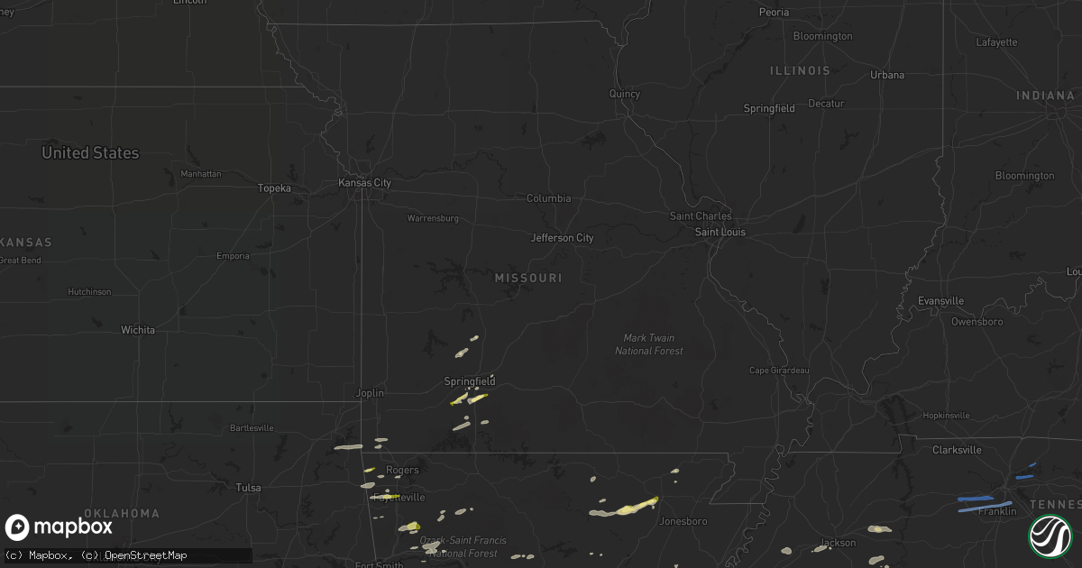
Hail Map in Missouri on October 12, 2022
Get this storm
October 12 map
$229
one time, instant access
Download today. No call, no setup
Keep the $229
Bought the map and want the full workflow? Apply the entire $229 to a subscription within 7 days. None of it is wasted.
Every map, not just this one
This buys you this map. Subscription and you get every map we run, in the markets you choose from a few cities to whole states to nationwide. Plus real-time alerts the moment a storm fires.
Contact data
Name, contact info, occupancy, even credit band for addresses in the footprint. You go from where it hit to who to call.
Become the source they trust
Unlimited branding weather history reports on demand. You already have the documented answer ready for the property owner, and you are the one who showed up with it.
Property data and RoofTrace estimates
Pull up any address you have got, its value and the exact code rules for that jurisdiction, straight from One Click Code. Then RoofTrace estimates the squares, pitch, and roof value, priced the way you price.
Storm reports in Missouri
Missouri
| Date | Description |
|---|---|
| 10/12/20228:15 AM CDT | Quarter size hail reported in ozark. |
| 10/12/20228:05 AM CDT | Photo sent via social media. |
| 10/12/20227:52 AM CDT | Quarter or larger hail between nixa and clever. Time and exact location estimated from radar. |
| 10/12/20226:23 AM CDT | At 1122 AM CDT, a severe thunderstorm was located near Datto, or near Corning, moving northeast at 40 mph. HAZARD...60 mph wind gusts and quarter size hail. SOURCE...Radar indicated. IMPACT...Hail damage to vehicles is expected. Expect wind damage to roofs, siding, and trees. Locations impacted include... Corning, Reyno, Knobel, McDougal, Datto, Crockett, Heelstring, Twin Oaks, Tipperary, Palatka and Hickoria. |
| 10/12/20223:32 AM CDT | At 831 AM CDT, a severe thunderstorm was located over Reeds Spring, or near Kimberling City, moving east at 55 mph. HAZARD...60 mph wind gusts and quarter size hail. SOURCE...Radar indicated. IMPACT...Hail damage to vehicles is expected. Expect wind damage to roofs, siding, and trees. Locations impacted include... Branson, Lake Taneycomo, Table Rock Lake, Shepherd of the Hills State Park, Silver Dollar City, Forsyth, Merriam Woods, Kissee Mills, Reeds Spring, Rockaway Beach, Bull Creek, Indian Point, Branson West, Galena, Taneyville, Mccord Bend, Spokane, Chestnutridge, Rome and Chadwick. |
| 10/12/20223:02 AM CDT | At 801 AM CDT, a severe thunderstorm was located over Nixa, moving northeast at 45 mph. HAZARD...60 mph wind gusts and quarter size hail. SOURCE...Radar indicated. IMPACT...Hail damage to vehicles is expected. Expect wind damage to roofs, siding, and trees. Locations impacted include... Southeastern Springfield, Nixa, Ozark, Battlefield, Rogersville, Seymour, Sparta, Highlandville, Fremont Hills, Fordland, Diggins, Turners, Linden and Galloway. |
All States Impacted by Hail Map on October 12, 2022
Cities Impacted by Hail Map on October 12, 2022
- Judsonia, AR
- Jay, OK
- Jackson, TN
- Ponca, AR
- Parthenon, AR
- Saltillo, TN
- Morris Chapel, TN
- Savannah, TN
- Collinwood, TN
- Lutts, TN
- Olivehill, TN
- Gentry, AR
- Siloam Springs, AR
- Albany, KY
- Alpha, KY
- Burkesville, KY
- Monticello, KY
- Ozark, AR
- Nixa, MO
- Clever, MO
- Billings, MO
- Belden, MS
- Tupelo, MS
- Pontotoc, MS
- Delaplaine, AR
- Hamburg, AR
- Jacksonville, AR
- Pineville, MO
- Anderson, MO
- Vaiden, MS
- Columbus, MS
- Cabot, AR
- Hazlehurst, MS
- Crystal Springs, MS
- Salina, OK
- Saint Paul, AR
- Witter, AR
- Pettigrew, AR
- Cleveland, AR
- Somerville, TN
- South West City, MO
- Afton, OK
- Grove, OK
- Rogersville, MO
- Strafford, MO
- Springfield, MO
- Clinton, AR
- Scotland, AR
- Fort Gay, WV
- Lowmansville, KY
- Crum, WV
- Wittensville, KY
- Inez, KY
- Ulysses, KY
- Tutor Key, KY
- River, KY
- Louisa, KY
- Stambaugh, KY
- Sitka, KY
- Paintsville, KY
- Flatgap, KY
- Oil Springs, KY
- Tomahawk, KY
- Staffordsville, KY
- Mulberry, AR
- Horseshoe Bend, AR
- Salem, AR
- Byhalia, MS
- Hernando, MS
- Coldwater, MS
- Reeds Spring, MO
- Galena, MO
- Cape Fair, MO
- Greenup, KY
- South Point, OH
- Ashland, KY
- Argillite, KY
- Kitts Hill, OH
- Flatwoods, KY
- Ironton, OH
- Noel, MO
- Alicia, AR
- Hoxie, AR
- Brownsville, TN
- Pangburn, AR
- Moro, AR
- Grand Junction, TN
- Hickory Valley, TN
- Marianna, AR
- Palestine, AR
- Benton, AR
- Bismarck, AR
- Courtland, MS
- Pittsboro, MS
- Randolph, MS
- Coffeeville, MS
- Water Valley, MS
- Oakland, MS
- Vance, MS
- Houlka, MS
- Pope, MS
- Big Creek, MS
- Vardaman, MS
- Banner, MS
- Calhoun City, MS
- Batesville, MS
- Coahoma, MS
- Enid, MS
- Lambert, MS
- Marks, MS
- Bruce, MS
- Parsons, TN
- Wildersville, TN
- Lexington, TN
- Darden, TN
- Salyersville, KY
- Hazel Green, KY
- Campton, KY
- Sardis, MS
- Carthage, AR
- Malvern, AR
- Donaldson, AR
- Sparkman, AR
- Leola, AR
- Arkadelphia, AR
- Sidney, AR
- Evening Shade, AR
- Watts, OK
- Colcord, OK
- Cherry Valley, AR
- Thaxton, MS
- Oxford, MS
- Blue Mountain, MS
- Holly Springs, MS
- De Witt, AR
- Gillett, AR
- Tichnor, AR
- Charleston, MS
- Duncan, MS
- Drew, MS
- Holcomb, MS
- Gunnison, MS
- Merigold, MS
- Ruleville, MS
- Snow Lake, AR
- Mound Bayou, MS
- Greenwood, MS
- Shelby, MS
- Schlater, MS
- Minter City, MS
- Philipp, MS
- Aberdeen, MS
- Sparta, MO
- Ozark, MO
- Decatur, AR
- Canehill, AR
- Corning, AR
- Biggers, AR
- McRae, AR
- Searcy, AR
- Hartman, AR
- Clarksville, AR
- Gurdon, AR
- Collierville, TN
- Tutwiler, MS
- Tillatoba, MS
- Sumner, MS
- Half Way, MO
- Forsyth, MO
- Taneyville, MO
- Rogers, AR
- Lowell, AR
- Spokane, MO
- Alligator, MS
- Clarksdale, MS
- Crumrod, AR
- Cookeville, TN
- Saffell, AR
- Sulphur Rock, AR
- Strawberry, AR
- Mount Pleasant, AR
- Cave City, AR
- Lynn, AR
- Batesville, AR
- Mercer, TN
- Denmark, TN
- Fayetteville, AR
- Stanton, TN
- Enville, TN
- Reagan, TN
- Sardis, TN
- Scotts Hill, TN
- Scranton, AR
- New Blaine, AR
- Bolivar, TN
- Aliceville, AL
- Roland, AR
- Mayflower, AR
- Saint Charles, AR
- Hanceville, AL
- Paron, AR
- Oak Grove, LA
- Eudora, AR
- Owingsville, KY
- Morehead, KY
- Hillsboro, KY
- Sharpsburg, KY
- Tatum, TX
- Beckville, TX
- Wiergate, TX
- Jasper, TX
- Wadley, AL
- Tuskegee, AL
- Natchez, MS
- Crosby, MS
- Adamsville, TN
- Selmer, TN
- Bethel Springs, TN
- Stantonville, TN
- New Albany, MS
- El Dorado, AR
- Tallassee, AL
- Broxton, GA
- Jemison, AL
- Shelby, AL
- Columbiana, AL
- Calera, AL
- Taylor, AR
- McNeil, AR
- Bessemer, AL
- McCalla, AL
- Waterford, MS
- Union, MS
- Philadelphia, MS
- Walnut Grove, MS
- Lake, MS
- Princeton, LA
- Haughton, LA
- Sarah, MS
- Senatobia, MS
- Shubuta, MS
- Gilbertown, AL
- Silas, AL
- Waynesboro, MS
- Fulton, MS
- Morton, MS
- Camden, AR
- Converse, LA
- Lena, MS
- Forest, MS
- Como, MS
- Livingston, TX
- Warren, TX
- Woodville, TX
- Plantersville, MS
- Junction City, AR
- Haynesville, LA
- Giddings, TX
- Ledbetter, TX
- Lincoln, TX
- Lorman, MS
- White Hall, AR
- Mantachie, MS
- Frankville, AL
- Sheridan, AR
- Stamps, AR
- Pike Road, AL
- Mathews, AL
- Fitzpatrick, AL
- Union Church, MS
- Quitman, MS
- Butler, AL
- Jachin, AL
- Ward, AL
- Meridian, MS
- Lisman, AL
- Pennington, AL
- Shelbyville, TX
- Homer, LA
- Lisbon, LA
- Summerfield, LA
- Gallion, AL
- Horn Lake, MS
- Memphis, TN
- Southaven, MS
- Lake Providence, LA
- Apple Springs, TX
- Groveton, TX
- Houston, MS
- Okolona, MS
- Portland, AR
- Bentley, LA
- Trout, LA
- Ball, LA
- Boyce, LA
- Dry Prong, LA
- Pineville, LA
- Alexandria, LA
- Jena, LA
- Pollock, LA
- Jonesville, LA
- Olla, LA
- Cecil, AL
- Tunica, MS
- Lake Village, AR
- Montrose, AR
- Ethel, LA
- Pitkin, LA
- Franklin, TX
- Marquez, TX
- Antoine, AR
- Okolona, AR
- Delight, AR
- Enterprise, MS
- Greenwood Springs, MS
- Blue Springs, MS
- Myrtle, MS
- Abbeville, MS
- Baldwyn, MS
- Vina, AL
- Detroit, AL
- Guin, AL
- Booneville, MS
- Marietta, MS
- Mooreville, MS
- Ecru, MS
- Guntown, MS
- Brilliant, AL
- Tremont, MS
- Etta, MS
- Hamilton, AL
- Beaverton, AL
- Winfield, AL
- Nettleton, MS
- Saltillo, MS
- Newton, MS
- Rose Hill, MS
- Chunky, MS
- Hickory, MS
- Linden, AL
- Thomaston, AL
- Minden, LA
- Hampton, AR
- Clayton, AL
- Louisville, AL
- Midway, AL
- Banks, AL
- Shorter, AL
- Eupora, MS
- Walthall, MS
- Thomasville, AL
- Castor, LA
- Marshall, TX
- De Berry, TX
- Saint Francisville, LA
- Jackson, LA
- Roxie, MS
- Bearden, AR
- Jersey, AR
- Prescott, AR
- Chidester, AR
- Louin, MS
- Damascus, AR
- Greenbrier, AR
- Springfield, AR
- Summers, AR
- Farmington, AR
- Prairie Grove, AR
- Lincoln, AR
- Cedarbluff, MS
- Woodland, MS
- West Point, MS
- Paris, AR
- Magazine, AR
- Boligee, AL
- Eutaw, AL
- Lewisville, AR
- Dundee, MS
- Notasulga, AL
- Sulligent, AL
- Lawrence, MS
- Conehatta, MS
- Grapevine, AR
- Pine Bluff, AR
- Troup, TX
- Kosciusko, MS
- Potts Camp, MS
- Mantee, MS
- Liberty, MS
- Gloster, MS
- Stonewall, LA
- Keatchie, LA
- Gloster, LA
- Natchitoches, LA
- Campti, LA
- Garrison, TX
- Springhill, LA
- Winslow, AR
- Mountainburg, AR
- Elkins, AR
- Franklin, TN
- Harrisonburg, LA
- Greensboro, AL
- Demopolis, AL
- Faunsdale, AL
- Durant, MS
- Red Banks, MS
- Reklaw, TX
- Jacksonville, TX
- Elm Grove, LA
- Ringgold, LA
- Sarepta, LA
- Pachuta, MS
- Newbern, AL
- Uniontown, AL
- York, AL
- Stonewall, MS
- Toxey, AL
- Starkville, MS
- Sicily Island, LA
- Gibsland, LA
- Arcadia, LA
- Shuqualak, MS
- Macon, MS
- Moundville, AL
- Crossett, AR
- Fort Gaines, GA
- Abbeville, AL
- Plain Dealing, LA
- Overton, TX
- Anguilla, MS
- Shellman, GA
- Dawson, GA
- Colt, AR
- Morris, GA
- Cuthbert, GA
- Olive Branch, MS
- Walls, MS
- Lake Cormorant, MS
- Nesbit, MS
- Germantown, TN
- Shannon, MS
- Caledonia, MS
- Dermott, AR
- Grayson, KY
- Olive Hill, KY
- Cotton Valley, LA
- Benton, LA
- Forrest City, AR
- Tiplersville, MS
- Walnut, MS
- Falkner, MS
- Ripley, MS
- Ashland, MS
- Sherwood, AR
- England, AR
- Rayville, LA
- Kilgore, TX
- Decatur, MS
- Coushatta, LA
- Daviston, AL
- Goodwater, AL
- Rockford, AL
- Millry, AL
- Kennard, TX
- San Augustine, TX
- Center, TX
- Nacogdoches, TX
- Normangee, TX
- Wilson, LA
- Dumas, MS
- New Site, MS
- Golden, MS
- Eldridge, AL
- Rienzi, MS
- Crenshaw, MS
- Port Gibson, MS
- Russell, KY
- Leesville, LA
- Hamilton, MS
- Saline, LA
- Robeline, LA
- Morrisville, MO
- Shongaloo, LA
- Doyline, LA
- Nashville, GA
- Willacoochee, GA
- Greenville, MS
- Bradley, AR
- Clinton, LA
- Sledge, MS
- Kirby, AR
- Langley, AR
- Fayette, MS
- Clanton, AL
- Wray, GA
- Centreville, MS
- Magnolia, AR
- Stephens, AR
- Simsboro, LA
- Ramer, AL
- Montgomery, AL
- Jamestown, LA
- Cedar Creek, TX
- Lexington, MS
- West, MS
- Alexander City, AL
- Provencal, LA
- Murfreesboro, AR
- Mansfield, LA
- Mount Holly, AR
- Plaucheville, LA
- Moreauville, LA
- Simmesport, LA
- Dadeville, AL
- Athens, LA
- Henderson, TX
- Otis, LA
- Dayton, TX
- Coleman, GA
- Hermitage, AR
- Amity, AR
- Louann, AR
- Bluff City, AR
- Mellwood, AR
- Ashland, LA
- Verbena, AL
- Brookwood, AL
- Coffeeville, AL
- Millport, AL
- Prairie, MS
- Steens, MS
- Sallis, MS
- Emerson, AR
- Napoleonville, LA
- Bolivar, MO
- Brighton, MO
- Willard, MO
- Muldrow, OK
- Needham, AL
- Tuskegee Institute, AL
- Epps, LA
- Grand Cane, LA
- Frierson, LA
- Bossier City, LA
- Pierre Part, LA
- Brookeland, TX
- Deridder, LA
- Newton, TX
- Merryville, LA
- Burkeville, TX
- Pheba, MS
- Maben, MS
- Union Springs, AL
- Hickory Flat, MS
- Scooba, MS
- Hollandale, MS
- Butler, WI
- Menomonee Falls, WI
- Milwaukee, WI
- Oak Creek, WI
- Hales Corners, WI
- Brookfield, WI
- New Berlin, WI
- Greendale, WI
- Saint Francis, WI
- Cudahy, WI
- South Milwaukee, WI
- Watertown, WI
- Johnson Creek, WI
- Helenville, WI
- Dousman, WI
- Mukwonago, WI
- Waukesha, WI
- Whitewater, WI
- Burlington, WI
- Elkhorn, WI
- Pewaukee, WI
- Union Grove, WI
- Sturtevant, WI
- Franksville, WI
- Racine, WI
- Waterford, WI
- Burns, TN
- Fairview, TN
- Dickson, TN
- Kingston Springs, TN
- Nashville, TN
- Brentwood, TN
- Antioch, TN
- Bon Aqua, TN
- Lyles, TN
- Gallatin, TN
- Mount Juliet, TN
- Hendersonville, TN
- Old Hickory, TN
- Lebanon, TN
- Austin, AR


