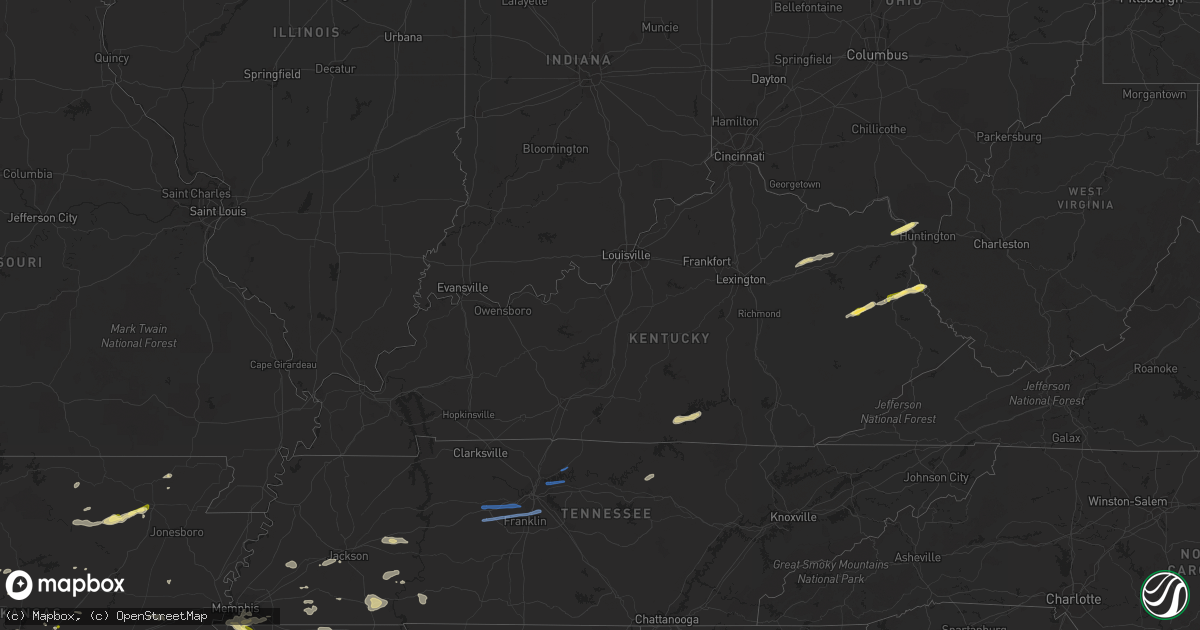
Hail Map in Kentucky on October 12, 2022
Get this storm
October 12 map
$229
one time, instant access
Download today. No call, no setup
Keep the $229
Bought the map and want the full workflow? Apply the entire $229 to a subscription within 7 days. None of it is wasted.
Every map, not just this one
This buys you this map. Subscription and you get every map we run, in the markets you choose from a few cities to whole states to nationwide. Plus real-time alerts the moment a storm fires.
Contact data
Name, contact info, occupancy, even credit band for addresses in the footprint. You go from where it hit to who to call.
Become the source they trust
Unlimited branding weather history reports on demand. You already have the documented answer ready for the property owner, and you are the one who showed up with it.
Property data and RoofTrace estimates
Pull up any address you have got, its value and the exact code rules for that jurisdiction, straight from One Click Code. Then RoofTrace estimates the squares, pitch, and roof value, priced the way you price.
Storm reports in Kentucky
Kentucky
| Date | Description |
|---|---|
| 10/12/20225:24 PM CDT | An open air barn had its roof peeled off and thrown into the field east of the barn. The nws storm survey team noted that the wood of the barn was dry rotted and weathe |
| 10/12/20225:22 PM CDT | A barn was moved off its foundation and lost its roof. According to the nws storm survey team... The cement block footers showed no indication of anchors to the barn an |
| 10/12/20225:21 PM CDT | A peg construction barn collapsed with most debris uniformly laying towards the ene and ne. The roof was dislodged and tossed 150 feet to the east of the barn... But th |
| 10/12/20225:21 PM CDT | Corrects previous tstm wnd dmg report from 2 nw odessa. Trees down along east fork road. Time estimated from radar. |
| 10/12/20225:21 PM CDT | Trees down along east fork road. |
| 10/12/20225:21 PM CDT | Multiple tree limbs between 5 and 7 inches in diameter were downed due to thunderstorm winds. Trees did not appear to be rotted... And were all laying uniformly towards |
| 10/12/20225:20 PM CDT | Multiple barns and farm structures |
| 10/12/20225:20 PM CDT | An older barn lost a large section of the roofing... Causing one side to collapse. The roof sections were intact and traveled about 30 feet eastward... Away from the ba |
| 10/12/20225:20 PM CDT | Thunderstorm winds led to the destruction of 2 barns on a property. The barns were old... And were not anchored down to the ground. One barn was moved off its foundatio |
| 10/12/20225:18 PM CDT | Corrects previous tstm wnd dmg report from odessa. Trees down along white oak road off of highway 36. Time estimated from radar. |
| 10/12/20225:18 PM CDT | Trees down along white oak road off of highway 36. |
| 10/12/20225:13 PM CDT | Corrects previous tstm wnd dmg report from reynoldsville. Thunderstorm wind gusts caused significant damage to a barn and an out building in the reynoldsville area. At |
| 10/12/20225:13 PM CDT | Thunderstorm wind gusts caused significant damage to a barn and an out building in the reynoldsville area. At least a couple of very large tree limbs were also brought |
| 10/12/20225:08 PM CDT | Trees reported down near the intersection of knob lick road and sulphur well knob lick road. |
| 10/12/20225:05 PM CDT | Corrects previous tstm wnd dmg report from 1 ne flat creek. Tree down along flat creek road. Time estimated from radar. |
| 10/12/20225:05 PM CDT | Tree down along flat creek road. |
| 10/12/20222:54 PM CDT | Trees were reported to have been blown down along ky 2019. The event time is radar estimate. |
| 10/12/20222:50 PM CDT | Trees were reported to have been blown down along ky 460 near the morgan county line. The event time is estimated. |
| 10/12/20222:27 PM CDT | Trees down on us route 62 just west of sardis. Damage to a barn roof. |
| 10/12/20221:43 AM CDT | At 643 PM EDT, a severe thunderstorm was located over Hilda, or near Morehead, moving northeast at 30 mph. HAZARD...60 mph wind gusts and quarter size hail. SOURCE...Radar indicated. IMPACT...Hail damage to vehicles is expected. Expect wind damage to roofs, siding, and trees. This severe thunderstorm will be near... Cranston around 650 PM EDT. Waltz around 655 PM EDT. Triplett around 700 PM EDT. |
| 10/12/20221:21 AM CDT | At 621 PM EDT, a severe thunderstorm was located over Wyoming, or near Owingsville, moving northeast at 35 mph. HAZARD...60 mph wind gusts and quarter size hail. SOURCE...Radar indicated. IMPACT...Hail damage to vehicles is expected. Expect wind damage to roofs, siding, and trees. This severe thunderstorm will be near... Grange City around 625 PM EDT. Hillsboro around 630 PM EDT. Ringos Mills around 635 PM EDT. Plummers Landing around 640 PM EDT.Other locations in the path of this severe thunderstorm include MusesMills. |
| 10/12/20221:10 AM CDT | At 609 PM EDT/509 PM CDT/, a severe thunderstorm was located near Greensburg, moving east at 25 mph. HAZARD...60 mph wind gusts. SOURCE...Radar indicated. IMPACT...Expect damage to roofs, siding, and trees. This severe thunderstorm will remain over mainly rural areas of southeastern Green, south central Taylor and north central Adair Counties, including the following locations... Gresham, Cane Valley, Absher, Mount Gilead, Haskingsville, Yuma, Burdick, Coburg, Romine and Roachville. |
| 10/12/202212:04 AM CDT | At 504 PM CDT, a severe thunderstorm was located 8 miles northwest of Edmonton, moving east at 20 mph. HAZARD...60 mph wind gusts. SOURCE...Radar indicated. IMPACT...Expect damage to roofs, siding, and trees. This severe thunderstorm will remain over mainly rural areas of southwestern Green and northwestern Metcalfe Counties, including the following locations... Liletown, Newt, Pierce, Center, Little Barren, Node, Thurlow, Crailhope, Knob Lick and Beechville. |
| 10/11/202211:54 PM CDT | At 454 PM EDT, a severe thunderstorm was located near Calf Creek, or 7 miles northeast of Inez, moving northeast at 30 mph. HAZARD...60 mph wind gusts and quarter size hail. SOURCE...Radar indicated. IMPACT...Hail damage to vehicles is expected. Expect wind damage to roofs, siding, and trees. Locations impacted include... Kiahsville, Dunlow, Clifford, Glenhayes and Wilsondale. |
| 10/11/202211:38 PM CDT | At 438 PM EDT, a severe thunderstorm was located near Grayson, moving northeast at 30 mph. HAZARD...60 mph wind gusts and quarter size hail. SOURCE...Radar indicated. IMPACT...Hail damage to vehicles is expected. Expect wind damage to roofs, siding, and trees. Locations impacted include... Grayson, Princess, Oldtown, Naples, Coalton, Rush and Hopewell. This includes Interstate 64 in Kentucky between mile markers 167 and185. |
| 10/11/202211:38 PM CDT | At 437 PM CDT, a severe thunderstorm was located 7 miles northeast of Scottsville, moving east at 30 mph. HAZARD...60 mph wind gusts and penny size hail. SOURCE...Radar indicated. IMPACT...Expect damage to roofs, siding, and trees. This severe thunderstorm will remain over mainly rural areas of northwestern Monroe, northeastern Allen and southern Barren Counties, including the following locations... Dry Fork, Eighty Eight, Bristletown, Maynard, Lucas, Haywood, Sulphur Lick, Austin, Nobob and Tracy. |
| 10/11/202211:26 PM CDT | At 426 PM EDT, a severe thunderstorm was located near Steubenville, or near Monticello, moving northeast at 35 mph. HAZARD...60 mph wind gusts and quarter size hail. SOURCE...Radar indicated. IMPACT...Hail damage to vehicles is expected. Expect wind damage to roofs, siding, and trees. This severe thunderstorm will be near... Steubenville around 430 PM EDT. Mill Springs around 435 PM EDT. Naomi around 440 PM EDT. Frazer around 445 PM EDT.Other locations in the path of this severe thunderstorm includeBronston and Burnside. |
| 10/11/202211:25 PM CDT | At 424 PM EDT, a severe thunderstorm was located over Stambaugh, or near Paintsville, moving northeast at 35 mph. HAZARD...60 mph wind gusts and quarter size hail. SOURCE...Radar indicated. IMPACT...Hail damage to vehicles is expected. Expect wind damage to roofs, siding, and trees. Locations impacted include... Ulysses, Charley, Clifford and Gallup. |
| 10/11/202211:17 PM CDT | At 416 PM EDT/316 PM CDT/, a severe thunderstorm was located 9 miles east of Burkesville, moving northeast at 60 mph. HAZARD...60 mph wind gusts and nickel size hail. SOURCE...Radar indicated. IMPACT...Expect damage to roofs, siding, and trees. This severe thunderstorm will be near... Jamestown around 330 PM CDT. |
| 10/11/202211:09 PM CDT | At 409 PM EDT, a severe thunderstorm was located over Parnell, or 7 miles northwest of Monticello, moving northeast at 35 mph. HAZARD...60 mph wind gusts. SOURCE...Radar indicated. IMPACT...Expect damage to roofs, siding, and trees. This severe thunderstorm will remain over mainly rural areas of northwestern Wayne County. |
| 10/11/202211:06 PM CDT | At 406 PM EDT, a severe thunderstorm was located over Hargis, or 8 miles northeast of Salyersville, moving northeast at 35 mph. HAZARD...60 mph wind gusts and quarter size hail. SOURCE...Radar indicated. IMPACT...Hail damage to vehicles is expected. Expect wind damage to roofs, siding, and trees. This severe thunderstorm will be near... Elna around 410 PM EDT. Kerz around 420 PM EDT. Chandlerville around 425 PM EDT. |
| 10/11/202210:50 PM CDT | At 348 PM EDT, a severe thunderstorm was located 8 miles north of Albany, or 16 miles north of Byrdstown, moving northeast at 35 mph. HAZARD...60 mph wind gusts. SOURCE...Radar indicated. IMPACT...Expect damage to roofs, siding, and trees. This severe thunderstorm will be near... Cabell around 400 PM EDT.Other locations in the path of this severe thunderstorm includeParnell. |
| 10/11/202210:38 PM CDT | At 338 PM EDT, a severe thunderstorm was located over Netty, or 9 miles west of Salyersville, moving northeast at 35 mph. HAZARD...60 mph wind gusts and quarter size hail. SOURCE...Radar indicated. IMPACT...Hail damage to vehicles is expected. Expect wind damage to roofs, siding, and trees. This severe thunderstorm will be near... Patton around 345 PM EDT. Bloomington around 350 PM EDT. Plutarch around 355 PM EDT.Other locations in the path of this severe thunderstorm include Everand Minefork. |
| 10/11/20229:44 PM CDT | At 244 PM CDT, a severe thunderstorm was located 7 miles northwest of Albany, moving east at 35 mph. HAZARD...60 mph wind gusts and nickel size hail. SOURCE...Radar indicated. IMPACT...Expect damage to roofs, siding, and trees. This severe thunderstorm will remain over mainly rural areas of northern Clinton, south central Russell and east central Cumberland Counties, including the following locations... Aaron, Desda, Cumberland City, Ida, Willis Creek, Marlow, Long Bottom, Narvel, Seventy Six and Rowena. |
All States Impacted by Hail Map on October 12, 2022
Cities Impacted by Hail Map on October 12, 2022
- Judsonia, AR
- Jay, OK
- Jackson, TN
- Ponca, AR
- Parthenon, AR
- Saltillo, TN
- Morris Chapel, TN
- Savannah, TN
- Collinwood, TN
- Lutts, TN
- Olivehill, TN
- Gentry, AR
- Siloam Springs, AR
- Albany, KY
- Alpha, KY
- Burkesville, KY
- Monticello, KY
- Ozark, AR
- Nixa, MO
- Clever, MO
- Billings, MO
- Belden, MS
- Tupelo, MS
- Pontotoc, MS
- Delaplaine, AR
- Hamburg, AR
- Jacksonville, AR
- Pineville, MO
- Anderson, MO
- Vaiden, MS
- Columbus, MS
- Cabot, AR
- Hazlehurst, MS
- Crystal Springs, MS
- Salina, OK
- Saint Paul, AR
- Witter, AR
- Pettigrew, AR
- Cleveland, AR
- Somerville, TN
- South West City, MO
- Afton, OK
- Grove, OK
- Rogersville, MO
- Strafford, MO
- Springfield, MO
- Clinton, AR
- Scotland, AR
- Fort Gay, WV
- Lowmansville, KY
- Crum, WV
- Wittensville, KY
- Inez, KY
- Ulysses, KY
- Tutor Key, KY
- River, KY
- Louisa, KY
- Stambaugh, KY
- Sitka, KY
- Paintsville, KY
- Flatgap, KY
- Oil Springs, KY
- Tomahawk, KY
- Staffordsville, KY
- Mulberry, AR
- Horseshoe Bend, AR
- Salem, AR
- Byhalia, MS
- Hernando, MS
- Coldwater, MS
- Reeds Spring, MO
- Galena, MO
- Cape Fair, MO
- Greenup, KY
- South Point, OH
- Ashland, KY
- Argillite, KY
- Kitts Hill, OH
- Flatwoods, KY
- Ironton, OH
- Noel, MO
- Alicia, AR
- Hoxie, AR
- Brownsville, TN
- Pangburn, AR
- Moro, AR
- Grand Junction, TN
- Hickory Valley, TN
- Marianna, AR
- Palestine, AR
- Benton, AR
- Bismarck, AR
- Courtland, MS
- Pittsboro, MS
- Randolph, MS
- Coffeeville, MS
- Water Valley, MS
- Oakland, MS
- Vance, MS
- Houlka, MS
- Pope, MS
- Big Creek, MS
- Vardaman, MS
- Banner, MS
- Calhoun City, MS
- Batesville, MS
- Coahoma, MS
- Enid, MS
- Lambert, MS
- Marks, MS
- Bruce, MS
- Parsons, TN
- Wildersville, TN
- Lexington, TN
- Darden, TN
- Salyersville, KY
- Hazel Green, KY
- Campton, KY
- Sardis, MS
- Carthage, AR
- Malvern, AR
- Donaldson, AR
- Sparkman, AR
- Leola, AR
- Arkadelphia, AR
- Sidney, AR
- Evening Shade, AR
- Watts, OK
- Colcord, OK
- Cherry Valley, AR
- Thaxton, MS
- Oxford, MS
- Blue Mountain, MS
- Holly Springs, MS
- De Witt, AR
- Gillett, AR
- Tichnor, AR
- Charleston, MS
- Duncan, MS
- Drew, MS
- Holcomb, MS
- Gunnison, MS
- Merigold, MS
- Ruleville, MS
- Snow Lake, AR
- Mound Bayou, MS
- Greenwood, MS
- Shelby, MS
- Schlater, MS
- Minter City, MS
- Philipp, MS
- Aberdeen, MS
- Sparta, MO
- Ozark, MO
- Decatur, AR
- Canehill, AR
- Corning, AR
- Biggers, AR
- McRae, AR
- Searcy, AR
- Hartman, AR
- Clarksville, AR
- Gurdon, AR
- Collierville, TN
- Tutwiler, MS
- Tillatoba, MS
- Sumner, MS
- Half Way, MO
- Forsyth, MO
- Taneyville, MO
- Rogers, AR
- Lowell, AR
- Spokane, MO
- Alligator, MS
- Clarksdale, MS
- Crumrod, AR
- Cookeville, TN
- Saffell, AR
- Sulphur Rock, AR
- Strawberry, AR
- Mount Pleasant, AR
- Cave City, AR
- Lynn, AR
- Batesville, AR
- Mercer, TN
- Denmark, TN
- Fayetteville, AR
- Stanton, TN
- Enville, TN
- Reagan, TN
- Sardis, TN
- Scotts Hill, TN
- Scranton, AR
- New Blaine, AR
- Bolivar, TN
- Aliceville, AL
- Roland, AR
- Mayflower, AR
- Saint Charles, AR
- Hanceville, AL
- Paron, AR
- Oak Grove, LA
- Eudora, AR
- Owingsville, KY
- Morehead, KY
- Hillsboro, KY
- Sharpsburg, KY
- Tatum, TX
- Beckville, TX
- Wiergate, TX
- Jasper, TX
- Wadley, AL
- Tuskegee, AL
- Natchez, MS
- Crosby, MS
- Adamsville, TN
- Selmer, TN
- Bethel Springs, TN
- Stantonville, TN
- New Albany, MS
- El Dorado, AR
- Tallassee, AL
- Broxton, GA
- Jemison, AL
- Shelby, AL
- Columbiana, AL
- Calera, AL
- Taylor, AR
- McNeil, AR
- Bessemer, AL
- McCalla, AL
- Waterford, MS
- Union, MS
- Philadelphia, MS
- Walnut Grove, MS
- Lake, MS
- Princeton, LA
- Haughton, LA
- Sarah, MS
- Senatobia, MS
- Shubuta, MS
- Gilbertown, AL
- Silas, AL
- Waynesboro, MS
- Fulton, MS
- Morton, MS
- Camden, AR
- Converse, LA
- Lena, MS
- Forest, MS
- Como, MS
- Livingston, TX
- Warren, TX
- Woodville, TX
- Plantersville, MS
- Junction City, AR
- Haynesville, LA
- Giddings, TX
- Ledbetter, TX
- Lincoln, TX
- Lorman, MS
- White Hall, AR
- Mantachie, MS
- Frankville, AL
- Sheridan, AR
- Stamps, AR
- Pike Road, AL
- Mathews, AL
- Fitzpatrick, AL
- Union Church, MS
- Quitman, MS
- Butler, AL
- Jachin, AL
- Ward, AL
- Meridian, MS
- Lisman, AL
- Pennington, AL
- Shelbyville, TX
- Homer, LA
- Lisbon, LA
- Summerfield, LA
- Gallion, AL
- Horn Lake, MS
- Memphis, TN
- Southaven, MS
- Lake Providence, LA
- Apple Springs, TX
- Groveton, TX
- Houston, MS
- Okolona, MS
- Portland, AR
- Bentley, LA
- Trout, LA
- Ball, LA
- Boyce, LA
- Dry Prong, LA
- Pineville, LA
- Alexandria, LA
- Jena, LA
- Pollock, LA
- Jonesville, LA
- Olla, LA
- Cecil, AL
- Tunica, MS
- Lake Village, AR
- Montrose, AR
- Ethel, LA
- Pitkin, LA
- Franklin, TX
- Marquez, TX
- Antoine, AR
- Okolona, AR
- Delight, AR
- Enterprise, MS
- Greenwood Springs, MS
- Blue Springs, MS
- Myrtle, MS
- Abbeville, MS
- Baldwyn, MS
- Vina, AL
- Detroit, AL
- Guin, AL
- Booneville, MS
- Marietta, MS
- Mooreville, MS
- Ecru, MS
- Guntown, MS
- Brilliant, AL
- Tremont, MS
- Etta, MS
- Hamilton, AL
- Beaverton, AL
- Winfield, AL
- Nettleton, MS
- Saltillo, MS
- Newton, MS
- Rose Hill, MS
- Chunky, MS
- Hickory, MS
- Linden, AL
- Thomaston, AL
- Minden, LA
- Hampton, AR
- Clayton, AL
- Louisville, AL
- Midway, AL
- Banks, AL
- Shorter, AL
- Eupora, MS
- Walthall, MS
- Thomasville, AL
- Castor, LA
- Marshall, TX
- De Berry, TX
- Saint Francisville, LA
- Jackson, LA
- Roxie, MS
- Bearden, AR
- Jersey, AR
- Prescott, AR
- Chidester, AR
- Louin, MS
- Damascus, AR
- Greenbrier, AR
- Springfield, AR
- Summers, AR
- Farmington, AR
- Prairie Grove, AR
- Lincoln, AR
- Cedarbluff, MS
- Woodland, MS
- West Point, MS
- Paris, AR
- Magazine, AR
- Boligee, AL
- Eutaw, AL
- Lewisville, AR
- Dundee, MS
- Notasulga, AL
- Sulligent, AL
- Lawrence, MS
- Conehatta, MS
- Grapevine, AR
- Pine Bluff, AR
- Troup, TX
- Kosciusko, MS
- Potts Camp, MS
- Mantee, MS
- Liberty, MS
- Gloster, MS
- Stonewall, LA
- Keatchie, LA
- Gloster, LA
- Natchitoches, LA
- Campti, LA
- Garrison, TX
- Springhill, LA
- Winslow, AR
- Mountainburg, AR
- Elkins, AR
- Franklin, TN
- Harrisonburg, LA
- Greensboro, AL
- Demopolis, AL
- Faunsdale, AL
- Durant, MS
- Red Banks, MS
- Reklaw, TX
- Jacksonville, TX
- Elm Grove, LA
- Ringgold, LA
- Sarepta, LA
- Pachuta, MS
- Newbern, AL
- Uniontown, AL
- York, AL
- Stonewall, MS
- Toxey, AL
- Starkville, MS
- Sicily Island, LA
- Gibsland, LA
- Arcadia, LA
- Shuqualak, MS
- Macon, MS
- Moundville, AL
- Crossett, AR
- Fort Gaines, GA
- Abbeville, AL
- Plain Dealing, LA
- Overton, TX
- Anguilla, MS
- Shellman, GA
- Dawson, GA
- Colt, AR
- Morris, GA
- Cuthbert, GA
- Olive Branch, MS
- Walls, MS
- Lake Cormorant, MS
- Nesbit, MS
- Germantown, TN
- Shannon, MS
- Caledonia, MS
- Dermott, AR
- Grayson, KY
- Olive Hill, KY
- Cotton Valley, LA
- Benton, LA
- Forrest City, AR
- Tiplersville, MS
- Walnut, MS
- Falkner, MS
- Ripley, MS
- Ashland, MS
- Sherwood, AR
- England, AR
- Rayville, LA
- Kilgore, TX
- Decatur, MS
- Coushatta, LA
- Daviston, AL
- Goodwater, AL
- Rockford, AL
- Millry, AL
- Kennard, TX
- San Augustine, TX
- Center, TX
- Nacogdoches, TX
- Normangee, TX
- Wilson, LA
- Dumas, MS
- New Site, MS
- Golden, MS
- Eldridge, AL
- Rienzi, MS
- Crenshaw, MS
- Port Gibson, MS
- Russell, KY
- Leesville, LA
- Hamilton, MS
- Saline, LA
- Robeline, LA
- Morrisville, MO
- Shongaloo, LA
- Doyline, LA
- Nashville, GA
- Willacoochee, GA
- Greenville, MS
- Bradley, AR
- Clinton, LA
- Sledge, MS
- Kirby, AR
- Langley, AR
- Fayette, MS
- Clanton, AL
- Wray, GA
- Centreville, MS
- Magnolia, AR
- Stephens, AR
- Simsboro, LA
- Ramer, AL
- Montgomery, AL
- Jamestown, LA
- Cedar Creek, TX
- Lexington, MS
- West, MS
- Alexander City, AL
- Provencal, LA
- Murfreesboro, AR
- Mansfield, LA
- Mount Holly, AR
- Plaucheville, LA
- Moreauville, LA
- Simmesport, LA
- Dadeville, AL
- Athens, LA
- Henderson, TX
- Otis, LA
- Dayton, TX
- Coleman, GA
- Hermitage, AR
- Amity, AR
- Louann, AR
- Bluff City, AR
- Mellwood, AR
- Ashland, LA
- Verbena, AL
- Brookwood, AL
- Coffeeville, AL
- Millport, AL
- Prairie, MS
- Steens, MS
- Sallis, MS
- Emerson, AR
- Napoleonville, LA
- Bolivar, MO
- Brighton, MO
- Willard, MO
- Muldrow, OK
- Needham, AL
- Tuskegee Institute, AL
- Epps, LA
- Grand Cane, LA
- Frierson, LA
- Bossier City, LA
- Pierre Part, LA
- Brookeland, TX
- Deridder, LA
- Newton, TX
- Merryville, LA
- Burkeville, TX
- Pheba, MS
- Maben, MS
- Union Springs, AL
- Hickory Flat, MS
- Scooba, MS
- Hollandale, MS
- Butler, WI
- Menomonee Falls, WI
- Milwaukee, WI
- Oak Creek, WI
- Hales Corners, WI
- Brookfield, WI
- New Berlin, WI
- Greendale, WI
- Saint Francis, WI
- Cudahy, WI
- South Milwaukee, WI
- Watertown, WI
- Johnson Creek, WI
- Helenville, WI
- Dousman, WI
- Mukwonago, WI
- Waukesha, WI
- Whitewater, WI
- Burlington, WI
- Elkhorn, WI
- Pewaukee, WI
- Union Grove, WI
- Sturtevant, WI
- Franksville, WI
- Racine, WI
- Waterford, WI
- Burns, TN
- Fairview, TN
- Dickson, TN
- Kingston Springs, TN
- Nashville, TN
- Brentwood, TN
- Antioch, TN
- Bon Aqua, TN
- Lyles, TN
- Gallatin, TN
- Mount Juliet, TN
- Hendersonville, TN
- Old Hickory, TN
- Lebanon, TN
- Austin, AR


