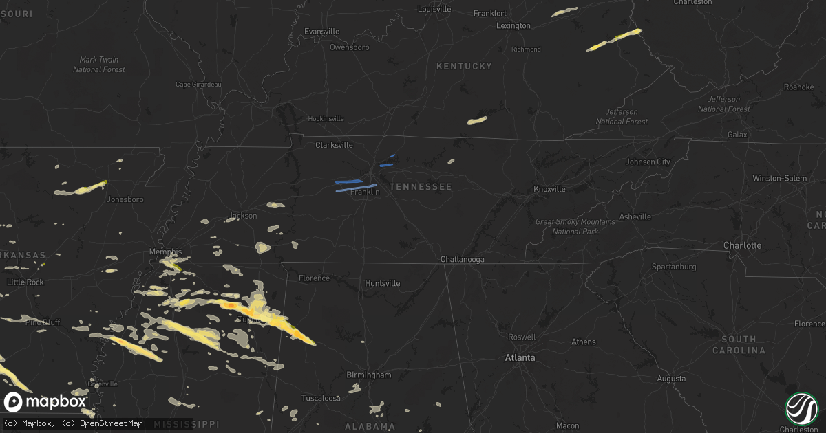
Hail Map in Tennessee on October 12, 2022
Get this storm
October 12 map
$229
one time, instant access
Download today. No call, no setup
Keep the $229
Bought the map and want the full workflow? Apply the entire $229 to a subscription within 7 days. None of it is wasted.
Every map, not just this one
This buys you this map. Subscription and you get every map we run, in the markets you choose from a few cities to whole states to nationwide. Plus real-time alerts the moment a storm fires.
Contact data
Name, contact info, occupancy, even credit band for addresses in the footprint. You go from where it hit to who to call.
Become the source they trust
Unlimited branding weather history reports on demand. You already have the documented answer ready for the property owner, and you are the one who showed up with it.
Property data and RoofTrace estimates
Pull up any address you have got, its value and the exact code rules for that jurisdiction, straight from One Click Code. Then RoofTrace estimates the squares, pitch, and roof value, priced the way you price.
Storm reports in Tennessee
Tennessee
| Date | Description |
|---|---|
| 10/12/20226:35 PM CDT | Awos station krnc mcminnville airport. |
| 10/12/20226:16 PM CDT | A small but intense 1/2 mile long by 250 yards wide microburst struck an area along interstate drive from around monogard drive southeastward to hwy 55. Sheet metal was |
| 10/12/20226:15 PM CDT | Large section of the raider academy gym was blown off. Winds were estimated up to 75 mph. |
| 10/12/20226:15 PM CDT | Significant wind damage occurred across manchester. Two gas stations at interstate dr and hwy 55 suffered awning and roof damage... A nearby building lost much of its r |
| 10/12/20226:14 PM CDT | Corrects previous tstm wnd dmg report from manchester. Numerous trees were blown down across manchester including at dave king park... A trailer court on oakdale street |
| 10/12/20226:13 PM CDT | Sign and fence blown down and mailbox blown off post on bashaw creek road. |
| 10/12/20226:12 PM CDT | Trees fell on power lines on college street at the intersection of hwy 41 and hwy 55. |
| 10/12/20225:58 PM CDT | Numerous trees were blown down along mt. Olivet rd and red gate ct. |
| 10/12/20225:57 PM CDT | Twitter tspotter reports of trees blown down in the 300 block of normandy rd... On hawthorne hill rd near flat creek... And on hwy 82 near himesville. |
| 10/12/20224:57 PM CDT | 24 inch diameter maple tree down on garage in dunn... South of lawrenceburg. |
| 10/12/20224:53 PM CDT | Social media reports showed several trees blown down in the summertown area with some blocking roads. |
| 10/12/20224:43 PM CDT | Several trees and power lines were blown down in the henryville area. |
| 10/12/20224:43 PM CDT | Two lanes blocked by fallen tree at the intersection of gallatin road and big station camp blvd. Tspotter report. |
| 10/12/20224:32 PM CDT | Tree down on fence. |
| 10/12/20224:32 PM CDT | Tree fell on a house in east nashville near mas tacos with siding damage on the house. |
| 10/12/20224:25 PM CDT | Twitter tspotter photo showed a tree snapped near crockett park. |
| 10/12/20224:21 PM CDT | Around 15 scattered reports of trees and power lines blown down were received from franklin to brentwood. |
| 10/12/20224:10 PM CDT | *** 1 fatal *** a tree was blown down onto a vehicle on old natchez trace killing a 22 year old woman. |
| 10/12/20224:03 PM CDT | Large trees down and blocking road on cumberland drive and sugar maple drive. |
| 10/12/20224:00 PM CDT | Large tree limbs down at the intersection of hwy 100 and westview blvd. |
| 10/12/20223:57 PM CDT | Gas station awning destroyed by winds near walmart in fairview. Tspotter report. |
| 10/12/20223:57 PM CDT | Fallen trees destroyed three trailer homes on festival ct near the walmart. |
| 10/12/20223:45 PM CDT | Steeple blown off east hickman baptist church. |
| 10/12/20223:33 PM CDT | Large tree branch down causing some roof damage to a house and also to a car. |
| 10/12/20223:05 PM CDT | Trees and powerlines down across saltillo... Pickwick... Big ivy... And gillis mills areas. |
| 10/12/202212:08 AM CDT | At 507 PM CDT, severe thunderstorms were located along a line extending from near Hartsville to near Lebanon, moving east at 45 mph. HAZARD...60 mph wind gusts and penny size hail. SOURCE...Radar indicated. IMPACT...Expect damage to roofs, siding, and trees. Locations impacted include... Lebanon, Carthage, Hartsville, Gordonsville, Hickman, South Carthage, Tuckers Crossroads, Dixon Springs, Pleasant Shade and Dickerson Chapel Recreation Area.This includes Interstate 40 between mile markers 236 and 262. |
| 10/11/202211:50 PM CDT | At 450 PM CDT, severe thunderstorms were located along a line extending from near Belinda City to 12 miles southwest of Murfreesboro, moving east at 40 mph. HAZARD...60 mph wind gusts and penny size hail. SOURCE...Radar indicated. IMPACT...Expect damage to roofs, siding, and trees. Locations impacted include... Murfreesboro, Lebanon, Woodbury, Smyrna, La Vergne, Mount Juliet, Watertown, Walterhill, Belinda City, Rural Hill, Auburntown, Lascassas, Tuckers Crossroads, Christiana, Fosterville, Cedars Of Lebanon State Park, Rover, Rockvale, Bradyville and Milton.This includes the following highways... Interstate 40 between mile markers 227 and 249. Interstate 24 between mile markers 69 and 95. Interstate 840 between mile markers 48 and 76. |
| 10/11/202211:41 PM CDT | At 441 PM CDT, a severe thunderstorm was located over Lakewood, or 11 miles southwest of Gallatin, moving east at 40 mph. HAZARD...60 mph wind gusts and penny size hail. SOURCE...Radar indicated. IMPACT...Expect damage to roofs, siding, and trees. Locations impacted include... Gallatin, Lebanon, Hendersonville, Mount Juliet, Lakewood, Hermitage, Old Hickory, Belinda City and Green Hill.This includes the following highways... Interstate 40 between mile markers 220 and 237. Interstate 840 between mile markers 72 and 76. |
| 10/11/202211:20 PM CDT | At 419 PM CDT, severe thunderstorms were located along a line extending from near Belle Meade to near Thompson's Station, moving east at 35 mph. HAZARD...70 mph wind gusts and penny size hail. SOURCE...Radar indicated. IMPACT...Expect considerable tree damage. Damage is likely to mobile homes, roofs, and outbuildings. Locations impacted include... Franklin, Nashville, Smyrna, Brentwood, La Vergne, Spring Hill, Nolensville, Forest Hills, Oak Hill, Belle Meade, Thompson's Station, Hermitage, Bellevue, Antioch, Rural Hill, Berry Hill, Bells Bend, Natchez Trace At Highway 96, Triune and Percy Priest Lake.This includes the following highways... Interstate 40 between mile markers 194 and 222. Interstate 65 between mile markers 56 and 86. Interstate 24 between mile markers 47 and 72. Interstate 840 between mile markers 23 and 51. |
| 10/11/202210:36 PM CDT | At 336 PM CDT, severe thunderstorms were located along a line extending from 7 miles north of Dickson to Centerville, moving east at 40 mph. HAZARD...60 mph wind gusts and nickel size hail. SOURCE...Radar indicated. IMPACT...Expect damage to roofs, siding, and trees. Locations impacted include... Dickson, Ashland City, Centerville, White Bluff, Kingston Springs, Pegram, Burns, Bellevue, Fairview, Charlotte, Vanleer, Bon Aqua, Bells Bend, Primm Springs, Lyles, Natchez Trace At Highway 96, Pinewood, Leipers Fork and Nunnelly.This includes the following highways... Interstate 40 between mile markers 161 and 202. Interstate 840 between mile markers 1 and 23. |
All States Impacted by Hail Map on October 12, 2022
Cities Impacted by Hail Map on October 12, 2022
- Judsonia, AR
- Jay, OK
- Jackson, TN
- Ponca, AR
- Parthenon, AR
- Saltillo, TN
- Morris Chapel, TN
- Savannah, TN
- Collinwood, TN
- Lutts, TN
- Olivehill, TN
- Gentry, AR
- Siloam Springs, AR
- Albany, KY
- Alpha, KY
- Burkesville, KY
- Monticello, KY
- Ozark, AR
- Nixa, MO
- Clever, MO
- Billings, MO
- Belden, MS
- Tupelo, MS
- Pontotoc, MS
- Delaplaine, AR
- Hamburg, AR
- Jacksonville, AR
- Pineville, MO
- Anderson, MO
- Vaiden, MS
- Columbus, MS
- Cabot, AR
- Hazlehurst, MS
- Crystal Springs, MS
- Salina, OK
- Saint Paul, AR
- Witter, AR
- Pettigrew, AR
- Cleveland, AR
- Somerville, TN
- South West City, MO
- Afton, OK
- Grove, OK
- Rogersville, MO
- Strafford, MO
- Springfield, MO
- Clinton, AR
- Scotland, AR
- Fort Gay, WV
- Lowmansville, KY
- Crum, WV
- Wittensville, KY
- Inez, KY
- Ulysses, KY
- Tutor Key, KY
- River, KY
- Louisa, KY
- Stambaugh, KY
- Sitka, KY
- Paintsville, KY
- Flatgap, KY
- Oil Springs, KY
- Tomahawk, KY
- Staffordsville, KY
- Mulberry, AR
- Horseshoe Bend, AR
- Salem, AR
- Byhalia, MS
- Hernando, MS
- Coldwater, MS
- Reeds Spring, MO
- Galena, MO
- Cape Fair, MO
- Greenup, KY
- South Point, OH
- Ashland, KY
- Argillite, KY
- Kitts Hill, OH
- Flatwoods, KY
- Ironton, OH
- Noel, MO
- Alicia, AR
- Hoxie, AR
- Brownsville, TN
- Pangburn, AR
- Moro, AR
- Grand Junction, TN
- Hickory Valley, TN
- Marianna, AR
- Palestine, AR
- Benton, AR
- Bismarck, AR
- Courtland, MS
- Pittsboro, MS
- Randolph, MS
- Coffeeville, MS
- Water Valley, MS
- Oakland, MS
- Vance, MS
- Houlka, MS
- Pope, MS
- Big Creek, MS
- Vardaman, MS
- Banner, MS
- Calhoun City, MS
- Batesville, MS
- Coahoma, MS
- Enid, MS
- Lambert, MS
- Marks, MS
- Bruce, MS
- Parsons, TN
- Wildersville, TN
- Lexington, TN
- Darden, TN
- Salyersville, KY
- Hazel Green, KY
- Campton, KY
- Sardis, MS
- Carthage, AR
- Malvern, AR
- Donaldson, AR
- Sparkman, AR
- Leola, AR
- Arkadelphia, AR
- Sidney, AR
- Evening Shade, AR
- Watts, OK
- Colcord, OK
- Cherry Valley, AR
- Thaxton, MS
- Oxford, MS
- Blue Mountain, MS
- Holly Springs, MS
- De Witt, AR
- Gillett, AR
- Tichnor, AR
- Charleston, MS
- Duncan, MS
- Drew, MS
- Holcomb, MS
- Gunnison, MS
- Merigold, MS
- Ruleville, MS
- Snow Lake, AR
- Mound Bayou, MS
- Greenwood, MS
- Shelby, MS
- Schlater, MS
- Minter City, MS
- Philipp, MS
- Aberdeen, MS
- Sparta, MO
- Ozark, MO
- Decatur, AR
- Canehill, AR
- Corning, AR
- Biggers, AR
- McRae, AR
- Searcy, AR
- Hartman, AR
- Clarksville, AR
- Gurdon, AR
- Collierville, TN
- Tutwiler, MS
- Tillatoba, MS
- Sumner, MS
- Half Way, MO
- Forsyth, MO
- Taneyville, MO
- Rogers, AR
- Lowell, AR
- Spokane, MO
- Alligator, MS
- Clarksdale, MS
- Crumrod, AR
- Cookeville, TN
- Saffell, AR
- Sulphur Rock, AR
- Strawberry, AR
- Mount Pleasant, AR
- Cave City, AR
- Lynn, AR
- Batesville, AR
- Mercer, TN
- Denmark, TN
- Fayetteville, AR
- Stanton, TN
- Enville, TN
- Reagan, TN
- Sardis, TN
- Scotts Hill, TN
- Scranton, AR
- New Blaine, AR
- Bolivar, TN
- Aliceville, AL
- Roland, AR
- Mayflower, AR
- Saint Charles, AR
- Hanceville, AL
- Paron, AR
- Oak Grove, LA
- Eudora, AR
- Owingsville, KY
- Morehead, KY
- Hillsboro, KY
- Sharpsburg, KY
- Tatum, TX
- Beckville, TX
- Wiergate, TX
- Jasper, TX
- Wadley, AL
- Tuskegee, AL
- Natchez, MS
- Crosby, MS
- Adamsville, TN
- Selmer, TN
- Bethel Springs, TN
- Stantonville, TN
- New Albany, MS
- El Dorado, AR
- Tallassee, AL
- Broxton, GA
- Jemison, AL
- Shelby, AL
- Columbiana, AL
- Calera, AL
- Taylor, AR
- McNeil, AR
- Bessemer, AL
- McCalla, AL
- Waterford, MS
- Union, MS
- Philadelphia, MS
- Walnut Grove, MS
- Lake, MS
- Princeton, LA
- Haughton, LA
- Sarah, MS
- Senatobia, MS
- Shubuta, MS
- Gilbertown, AL
- Silas, AL
- Waynesboro, MS
- Fulton, MS
- Morton, MS
- Camden, AR
- Converse, LA
- Lena, MS
- Forest, MS
- Como, MS
- Livingston, TX
- Warren, TX
- Woodville, TX
- Plantersville, MS
- Junction City, AR
- Haynesville, LA
- Giddings, TX
- Ledbetter, TX
- Lincoln, TX
- Lorman, MS
- White Hall, AR
- Mantachie, MS
- Frankville, AL
- Sheridan, AR
- Stamps, AR
- Pike Road, AL
- Mathews, AL
- Fitzpatrick, AL
- Union Church, MS
- Quitman, MS
- Butler, AL
- Jachin, AL
- Ward, AL
- Meridian, MS
- Lisman, AL
- Pennington, AL
- Shelbyville, TX
- Homer, LA
- Lisbon, LA
- Summerfield, LA
- Gallion, AL
- Horn Lake, MS
- Memphis, TN
- Southaven, MS
- Lake Providence, LA
- Apple Springs, TX
- Groveton, TX
- Houston, MS
- Okolona, MS
- Portland, AR
- Bentley, LA
- Trout, LA
- Ball, LA
- Boyce, LA
- Dry Prong, LA
- Pineville, LA
- Alexandria, LA
- Jena, LA
- Pollock, LA
- Jonesville, LA
- Olla, LA
- Cecil, AL
- Tunica, MS
- Lake Village, AR
- Montrose, AR
- Ethel, LA
- Pitkin, LA
- Franklin, TX
- Marquez, TX
- Antoine, AR
- Okolona, AR
- Delight, AR
- Enterprise, MS
- Greenwood Springs, MS
- Blue Springs, MS
- Myrtle, MS
- Abbeville, MS
- Baldwyn, MS
- Vina, AL
- Detroit, AL
- Guin, AL
- Booneville, MS
- Marietta, MS
- Mooreville, MS
- Ecru, MS
- Guntown, MS
- Brilliant, AL
- Tremont, MS
- Etta, MS
- Hamilton, AL
- Beaverton, AL
- Winfield, AL
- Nettleton, MS
- Saltillo, MS
- Newton, MS
- Rose Hill, MS
- Chunky, MS
- Hickory, MS
- Linden, AL
- Thomaston, AL
- Minden, LA
- Hampton, AR
- Clayton, AL
- Louisville, AL
- Midway, AL
- Banks, AL
- Shorter, AL
- Eupora, MS
- Walthall, MS
- Thomasville, AL
- Castor, LA
- Marshall, TX
- De Berry, TX
- Saint Francisville, LA
- Jackson, LA
- Roxie, MS
- Bearden, AR
- Jersey, AR
- Prescott, AR
- Chidester, AR
- Louin, MS
- Damascus, AR
- Greenbrier, AR
- Springfield, AR
- Summers, AR
- Farmington, AR
- Prairie Grove, AR
- Lincoln, AR
- Cedarbluff, MS
- Woodland, MS
- West Point, MS
- Paris, AR
- Magazine, AR
- Boligee, AL
- Eutaw, AL
- Lewisville, AR
- Dundee, MS
- Notasulga, AL
- Sulligent, AL
- Lawrence, MS
- Conehatta, MS
- Grapevine, AR
- Pine Bluff, AR
- Troup, TX
- Kosciusko, MS
- Potts Camp, MS
- Mantee, MS
- Liberty, MS
- Gloster, MS
- Stonewall, LA
- Keatchie, LA
- Gloster, LA
- Natchitoches, LA
- Campti, LA
- Garrison, TX
- Springhill, LA
- Winslow, AR
- Mountainburg, AR
- Elkins, AR
- Franklin, TN
- Harrisonburg, LA
- Greensboro, AL
- Demopolis, AL
- Faunsdale, AL
- Durant, MS
- Red Banks, MS
- Reklaw, TX
- Jacksonville, TX
- Elm Grove, LA
- Ringgold, LA
- Sarepta, LA
- Pachuta, MS
- Newbern, AL
- Uniontown, AL
- York, AL
- Stonewall, MS
- Toxey, AL
- Starkville, MS
- Sicily Island, LA
- Gibsland, LA
- Arcadia, LA
- Shuqualak, MS
- Macon, MS
- Moundville, AL
- Crossett, AR
- Fort Gaines, GA
- Abbeville, AL
- Plain Dealing, LA
- Overton, TX
- Anguilla, MS
- Shellman, GA
- Dawson, GA
- Colt, AR
- Morris, GA
- Cuthbert, GA
- Olive Branch, MS
- Walls, MS
- Lake Cormorant, MS
- Nesbit, MS
- Germantown, TN
- Shannon, MS
- Caledonia, MS
- Dermott, AR
- Grayson, KY
- Olive Hill, KY
- Cotton Valley, LA
- Benton, LA
- Forrest City, AR
- Tiplersville, MS
- Walnut, MS
- Falkner, MS
- Ripley, MS
- Ashland, MS
- Sherwood, AR
- England, AR
- Rayville, LA
- Kilgore, TX
- Decatur, MS
- Coushatta, LA
- Daviston, AL
- Goodwater, AL
- Rockford, AL
- Millry, AL
- Kennard, TX
- San Augustine, TX
- Center, TX
- Nacogdoches, TX
- Normangee, TX
- Wilson, LA
- Dumas, MS
- New Site, MS
- Golden, MS
- Eldridge, AL
- Rienzi, MS
- Crenshaw, MS
- Port Gibson, MS
- Russell, KY
- Leesville, LA
- Hamilton, MS
- Saline, LA
- Robeline, LA
- Morrisville, MO
- Shongaloo, LA
- Doyline, LA
- Nashville, GA
- Willacoochee, GA
- Greenville, MS
- Bradley, AR
- Clinton, LA
- Sledge, MS
- Kirby, AR
- Langley, AR
- Fayette, MS
- Clanton, AL
- Wray, GA
- Centreville, MS
- Magnolia, AR
- Stephens, AR
- Simsboro, LA
- Ramer, AL
- Montgomery, AL
- Jamestown, LA
- Cedar Creek, TX
- Lexington, MS
- West, MS
- Alexander City, AL
- Provencal, LA
- Murfreesboro, AR
- Mansfield, LA
- Mount Holly, AR
- Plaucheville, LA
- Moreauville, LA
- Simmesport, LA
- Dadeville, AL
- Athens, LA
- Henderson, TX
- Otis, LA
- Dayton, TX
- Coleman, GA
- Hermitage, AR
- Amity, AR
- Louann, AR
- Bluff City, AR
- Mellwood, AR
- Ashland, LA
- Verbena, AL
- Brookwood, AL
- Coffeeville, AL
- Millport, AL
- Prairie, MS
- Steens, MS
- Sallis, MS
- Emerson, AR
- Napoleonville, LA
- Bolivar, MO
- Brighton, MO
- Willard, MO
- Muldrow, OK
- Needham, AL
- Tuskegee Institute, AL
- Epps, LA
- Grand Cane, LA
- Frierson, LA
- Bossier City, LA
- Pierre Part, LA
- Brookeland, TX
- Deridder, LA
- Newton, TX
- Merryville, LA
- Burkeville, TX
- Pheba, MS
- Maben, MS
- Union Springs, AL
- Hickory Flat, MS
- Scooba, MS
- Hollandale, MS
- Butler, WI
- Menomonee Falls, WI
- Milwaukee, WI
- Oak Creek, WI
- Hales Corners, WI
- Brookfield, WI
- New Berlin, WI
- Greendale, WI
- Saint Francis, WI
- Cudahy, WI
- South Milwaukee, WI
- Watertown, WI
- Johnson Creek, WI
- Helenville, WI
- Dousman, WI
- Mukwonago, WI
- Waukesha, WI
- Whitewater, WI
- Burlington, WI
- Elkhorn, WI
- Pewaukee, WI
- Union Grove, WI
- Sturtevant, WI
- Franksville, WI
- Racine, WI
- Waterford, WI
- Burns, TN
- Fairview, TN
- Dickson, TN
- Kingston Springs, TN
- Nashville, TN
- Brentwood, TN
- Antioch, TN
- Bon Aqua, TN
- Lyles, TN
- Gallatin, TN
- Mount Juliet, TN
- Hendersonville, TN
- Old Hickory, TN
- Lebanon, TN
- Austin, AR


