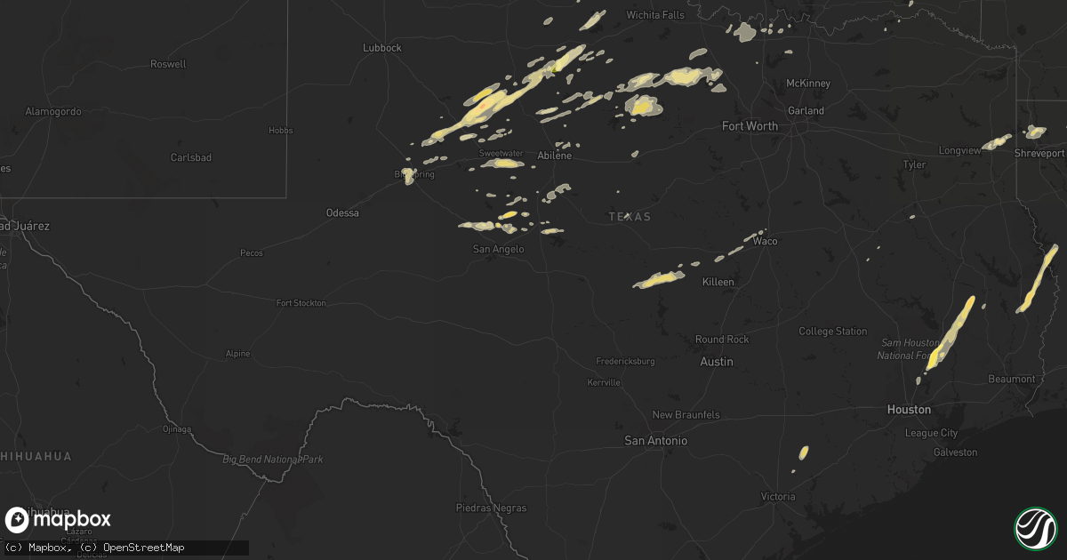
Hail Map in Texas on October 12, 2014
Get this storm
October 12 map
$229
one time, instant access
Download today. No call, no setup
Keep the $229
Bought the map and want the full workflow? Apply the entire $229 to a subscription within 7 days. None of it is wasted.
Every map, not just this one
This buys you this map. Subscription and you get every map we run, in the markets you choose from a few cities to whole states to nationwide. Plus real-time alerts the moment a storm fires.
Contact data
Name, contact info, occupancy, even credit band for addresses in the footprint. You go from where it hit to who to call.
Become the source they trust
Unlimited branding weather history reports on demand. You already have the documented answer ready for the property owner, and you are the one who showed up with it.
Property data and RoofTrace estimates
Pull up any address you have got, its value and the exact code rules for that jurisdiction, straight from One Click Code. Then RoofTrace estimates the squares, pitch, and roof value, priced the way you price.
Storm reports in Texas
Texas
| Date | Description |
|---|---|
| 10/12/20146:55 PM CDT | A local report indicates 60 MPH wind near 2 SW CANADIAN |
| 10/12/20146:40 PM CDT | A local report indicates 66 MPH wind near 10 N GROOM |
| 10/12/20146:29 PM CDT | A local report indicates 65 MPH wind near 10 ENE PALO DURO CANYON |
| 10/12/20146:09 PM CDT | A local report indicates 60 MPH wind near 2 S AMARILLO |
| 10/12/20146:09 PM CDT | A local report indicates 60 MPH wind near 6 NNW AMARILLO |
| 10/12/20146:08 PM CDT | A local report indicates 58 MPH wind near 1 NNW LAKE TANGLEWOOD |
| 10/12/20146:06 PM CDT | A local report indicates 59 MPH wind near 4 NNW LAKE TANGLEWOOD |
| 10/12/20146:05 PM CDT | A local report indicates 61 MPH wind near 11 WNW BOOTLEG |
| 10/12/20146:00 PM CDT | A local report indicates 59 MPH wind near 4 NNW AMARILLO |
| 10/12/20145:59 PM CDT | A local report indicates 59 MPH wind near 3 E BUSHLAND |
| 10/12/20145:58 PM CDT | A local report indicates 59 MPH wind near 2 N CANYON |
| 10/12/20145:53 PM CDT | Power lines down |
| 10/12/20145:49 PM CDT | A local report indicates 64 MPH wind near 11 WNW BOOTLEG |
| 10/12/20145:48 PM CDT | A local report indicates 62 MPH wind near 3 NNE UMBARGER |
| 10/12/20145:41 PM CDT | A local report indicates 60 MPH wind near 10 ESE VALLEY DE ORO |
| 10/12/20145:24 PM CDT | A local report indicates 60 MPH wind near 1 NNW HEREFORD |
| 10/12/20144:45 PM CDT | A local report indicates 1.75 inch wind near 1 SE CHESTER |
| 10/12/20144:35 PM CDT | Trees down near fm 2500 and puckett loop |
| 10/12/20143:48 PM CDT | Half dollar sized hail occurring in downtown cleveland. |
| 10/12/20146:53 AM CDT | Trees down all over county |
| 10/12/20146:44 AM CDT | Trees down all over county blocking hwys 84... 2138... 747 south... Cr 3908 ... 3708 |
| 10/12/20146:42 AM CDT | Numerous trees and power lines down in the southern portion of town on hwy 79 south and county road 407. |
| 10/12/20146:00 AM CDT | Csbf recorded peak gust of 68mph |
| 10/12/20145:21 AM CDT | Trees down... Barn blown down power lines down north of leesburg between leesburg and lake bob sandlin... Roads blocked |
| 10/12/20144:52 AM CDT | An ef-1 tornado touched down just south of fm 852 near the bison road and fm 852 intersection. The tornado moved east crossing fm 852 and passing along armadillo road n |
| 10/12/20144:25 AM CDT | A localized downburst affected a small area along interstate 30 on the south side of mount vernon...producing an estimated 70-80 mph winds. Damage consisted in the sign |
| 10/12/20144:05 AM CDT | A few trees down n of fairfield |
| 10/12/20144:00 AM CDT | Trees down in roadway |
| 10/12/20144:00 AM CDT | Trees down along sw 2090 near pursley |
| 10/12/20144:00 AM CDT | Trees down on fm 638 near the 638 and 642 intersection |
| 10/12/20143:35 AM CDT | Trees and branches down in terrell within an area between high/n rockwall/virginia/jackson streets. Chainsaws are needed to clear the trees and branches. |
| 10/12/20143:20 AM CDT | Delayed report via terrell tribune. Multiple reports of substantial tree damage |
| 10/12/20142:50 AM CDT | Delayed report of a portable outbuilding displaced around 30 ft with numerous trees uprooted |
| 10/12/20142:40 AM CDT | Thunderstorm winds knocked down large trees and tree limbs... New and metal post fences... And the shingles off roofs in a small area in sachse. A metal garage door was cav ( |
| 10/12/20142:18 AM CDT | Fence and large branches down in north plano at ridgeview and custer. |
| 10/12/20141:53 AM CDT | Power poles down on 380 on the west side of denton. 380 closed between hinkle dr. And malone st. |
| 10/12/20141:50 AM CDT | 18 wheeler blown over on its side |
| 10/12/20141:50 AM CDT | Some trees were blown down across the county. Locations include van alstyne and sherman |
| 10/12/20141:50 AM CDT | A local report indicates 1.50 inch wind near 7 SW BRONTE |
| 10/12/20141:50 AM CDT | The roof of fair hall at the north texas state fair grounds on n carroll blvd in denton was partially ripped off. |
| 10/12/20141:30 AM CDT | Unt campus |
| 10/12/20141:28 AM CDT | Large lines down across us 287 at cr 4838. Highway is shut down all directions. |
| 10/12/20141:26 AM CDT | A local report indicates 58 MPH wind near 9 SE DECATUR |
| 10/12/20141:24 AM CDT | Several power poles down on fm 2264 6 miles southeast of decatur. |
| 10/12/20141:22 AM CDT | Travel trailer turned on its side and shingles torn from multiple roofs 7 miles southeast of decatur |
| 10/12/20141:14 AM CDT | Numerous large tree limbs down. The limbs were in excess of 10 feet long. Numerous pecan trees uprooted. |
| 10/12/201412:46 AM CDT | Muenster pd reported 60-65 mph winds. |
| 10/12/201412:46 AM CDT | Silos damaged in the city of muenster. |
| 10/12/201412:40 AM CDT | Tree down blocking roadway ne of mineral wells |
| 10/12/201412:00 AM CDT | Foreman/construction trailer destroyed at new walmart construction site in breckenridge |
| 10/11/20149:01 PM CDT | A local report indicates 1.00 inch wind near WEINERT |
| 10/11/20149:00 PM CDT | A local report indicates 58 MPH wind near 3 NW KNOX CITY |
| 10/11/20149:00 PM CDT | A local report indicates 60 MPH wind near 3 NE ASPERMONT |
| 10/11/20147:26 PM CDT | A local report indicates 74 MPH wind near 3 W DOZIER |
| 10/11/20147:25 PM CDT | A local report indicates 68 MPH wind near 3 W DOZIER |
| 10/11/20147:00 PM CDT | A local report indicates 63 MPH wind near 11 N CLARENDON |
All States Impacted by Hail Map on October 12, 2014
Cities Impacted by Hail Map on October 12, 2014
- Hobart, OK
- Roosevelt, OK
- Olney, TX
- Newcastle, TX
- Loving, TX
- Graham, TX
- Edmond, OK
- Oklahoma City, OK
- Arapaho, OK
- Thomas, OK
- Weatherford, OK
- Clinton, OK
- Goodrich, TX
- New Caney, TX
- Livingston, TX
- Splendora, TX
- Chester, TX
- Shepherd, TX
- Dayton, TX
- Cleveland, TX
- Buffalo, OK
- Ashland, KS
- Wanette, OK
- Lexington, OK
- Blanket, TX
- Coldwater, KS
- Colorado City, TX
- Robert Lee, TX
- Follett, TX
- Henagar, AL
- Pisgah, AL
- Ider, AL
- Dutton, AL
- Flat Rock, AL
- Section, AL
- Bend, TX
- Lampasas, TX
- Lometa, TX
- San Saba, TX
- Fluvanna, TX
- Walters, OK
- Glen Allan, MS
- Shamrock, TX
- Wellington, TX
- Texola, OK
- Erick, OK
- Mustang, OK
- Yukon, OK
- Watonga, OK
- Nettleton, MS
- Anson, TX
- Stamford, TX
- Lueders, TX
- Avoca, TX
- Bowie, TX
- Jacksboro, TX
- Bryson, TX
- Vardaman, MS
- Bridgeport, TX
- Paradise, TX
- Jayton, TX
- Rotan, TX
- Snyder, TX
- Aspermont, TX
- Goldsboro, TX
- Novice, TX
- Winters, TX
- Benton, LA
- Shreveport, LA
- Voss, TX
- Ballinger, TX
- Wingate, TX
- Bronte, TX
- Geary, OK
- Calumet, OK
- Paducah, TX
- Seymour, TX
- Knox City, TX
- Old Glory, TX
- Decatur, TX
- Weinert, TX
- Munday, TX
- Hennessey, OK
- Meade, KS
- Watson, OK
- Eudora, AR
- Protection, KS
- Electra, TX
- Ira, TX
- Groveoak, AL
- Crossville, AL
- Albertville, AL
- Horton, AL
- Guntersville, AL
- Alvord, TX
- Chico, TX
- Goree, TX
- Colony, OK
- Cordell, OK
- Wilmore, KS
- Norton, TX
- Carter, OK
- Elk City, OK
- Dawson, AL
- Englewood, KS
- Dodson, LA
- Winnfield, LA
- Homer, LA
- Shongaloo, LA
- Cotton Valley, LA
- Haynesville, LA
- Minden, LA
- Burbank, OK
- Canute, OK
- Lone Wolf, OK
- Hinton, OK
- Dill City, OK
- Foss, OK
- Willow, OK
- Bessie, OK
- Hydro, OK
- Corn, OK
- Sentinel, OK
- Humble, TX
- Kingwood, TX
- Porter, TX
- O'Brien, TX
- Rochester, TX
- Big Spring, TX
- Abilene, TX
- Hooker, OK
- Tupelo, MS
- Pontotoc, MS
- Belden, MS
- Woodson, TX
- Throckmorton, TX
- Plains, KS
- Fyffe, AL
- Collinsville, AL
- Geraldine, AL
- Many, LA
- Jasper, TX
- Newton, TX
- Wiergate, TX
- Hemphill, TX
- Florien, LA
- Hallettsville, TX
- Rule, TX
- Sunflower, MS
- Powderly, TX
- Breckenridge, TX
- Graford, TX
- South Bend, TX
- Carbon Hill, AL
- Oakman, AL
- Jasper, AL
- Townley, AL
- Forgan, OK
- Gate, OK
- Turpin, OK
- Kismet, KS
- Liberal, KS
- Davidson, OK
- Hermleigh, TX
- Rolling Fork, MS
- Hollandale, MS
- Carlsbad, TX
- Gainesboro, TN
- Whitleyville, TN
- Bernice, LA
- Spearsville, LA
- Lillie, LA
- Junction City, AR
- El Dorado, AR
- Granville, TN
- Bloomington Springs, TN
- Buffalo Valley, TN
- Baxter, TN
- Merkel, TX
- Tioga, TX
- Collinsville, TX
- Gunter, TX
- Waco, TX
- China Spring, TX
- Crawford, TX
- Woodway, TX
- Grandfield, OK
- Sumner, TX
- Bellevue, TX
- Coahoma, TX
- Garwood, TX
- Edna, TX
- Copperas Cove, TX
- Sweetwater, TX
- Celina, TN
- Saint Jo, TX
- Nocona, TX
- Rising Star, TX
- Tremont, MS
- Marion, LA
- Canadian, TX
- Gainesville, TX
- Thackerville, OK
- Marshall, TX
- Karnack, TX
- Whitesboro, TX
- Aimwell, LA
- Harrisonburg, LA
- Altus, OK
- Fulton, MS
- Roscoe, TX
- Nolan, TX
- Miles, TX
- San Angelo, TX
- Reform, AL
- Millport, AL
- Gotebo, OK
- Mountain View, OK
- Rudy, AR
- Muenster, TX
- Lindsay, TX
- Oklaunion, TX
- Burkesville, KY
- Tompkinsville, KY
- Silver Point, TN
- Hilham, TN
- Moss, TN
- Doddsville, MS
- Indianola, MS
- Moorhead, MS
- Sadler, TX
- Mooringsport, LA
- Belcher, LA
- Anguilla, MS
- Roby, TX
- Bear Creek, AL
- Hackleburg, AL
- Ranger, TX
- Eastland, TX
- Crowell, TX
- Blackwell, TX
- Fayette, AL
- Bankston, AL
- Boynton, OK
- Hugoton, KS
- Albany, TX
- Fletcher, OK
- Lawton, OK
- Elgin, OK
- Marthaville, LA
- Berry, AL
- Cordova, AL
- Rusk, TX
- Jacksonville, TX
- Plantersville, MS
- Shannon, MS
- Okolona, MS
- Greenfield, TN
- Gleason, TN
- Dresden, TN
- Headrick, OK
- Blair, OK
- Olustee, OK
- Coffeeville, MS
- Grenada, MS
- Ethelsville, AL
- Jermyn, TX
- Oakwood, TX
- Ovalo, TX
- Lawn, TX
- Clyde, TX
- Covington, OK
- Bruce, MS
- Chillicothe, TX
- Vernon, TX
- Gail, TX
- Healdton, OK
- Sawyer, OK
- Colmesneil, TX
- Woodville, TX
- Perrin, TX
- Harrold, TX
- Sanger, TX
- Perry, OK
- Ringling, OK
- Strawn, TX
- Murray, KY
- Magnolia, AR
- Westbrook, TX
- Haskell, TX
- Sylvester, TX
- Oglesby, TX
- McGregor, TX
- Houlka, MS
- Hodgen, OK
- Eldridge, AL
- Mayersville, MS
- Winnsboro, LA
- Lookeba, OK
- Butler, OK
- Gatesville, TX


