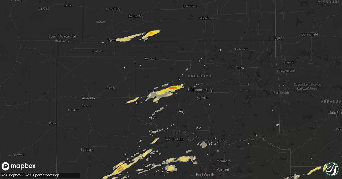
Hail Map on October 12, 2014
Get this storm
October 12 map
$229
one time, instant access
Download today. No call, no setup
Keep the $229
Bought the map and want the full workflow? Apply the entire $229 to a subscription within 7 days. None of it is wasted.
Every map, not just this one
This buys you this map. Subscription and you get every map we run, in the markets you choose from a few cities to whole states to nationwide. Plus real-time alerts the moment a storm fires.
Contact data
Name, contact info, occupancy, even credit band for addresses in the footprint. You go from where it hit to who to call.
Become the source they trust
Unlimited branding weather history reports on demand. You already have the documented answer ready for the property owner, and you are the one who showed up with it.
Property data and RoofTrace estimates
Pull up any address you have got, its value and the exact code rules for that jurisdiction, straight from One Click Code. Then RoofTrace estimates the squares, pitch, and roof value, priced the way you price.
States Impacted by Hail Map on October 12, 2014
Storm reports
Texas
| Date | Description |
|---|---|
| 10/12/20146:55 PM CDT | A local report indicates 60 MPH wind near 2 SW CANADIAN |
| 10/12/20146:40 PM CDT | A local report indicates 66 MPH wind near 10 N GROOM |
| 10/12/20146:29 PM CDT | A local report indicates 65 MPH wind near 10 ENE PALO DURO CANYON |
| 10/12/20146:09 PM CDT | A local report indicates 60 MPH wind near 6 NNW AMARILLO |
| 10/12/20146:09 PM CDT | A local report indicates 60 MPH wind near 2 S AMARILLO |
| 10/12/20146:08 PM CDT | A local report indicates 58 MPH wind near 1 NNW LAKE TANGLEWOOD |
| 10/12/20146:06 PM CDT | A local report indicates 59 MPH wind near 4 NNW LAKE TANGLEWOOD |
| 10/12/20146:05 PM CDT | A local report indicates 61 MPH wind near 11 WNW BOOTLEG |
| 10/12/20146:00 PM CDT | A local report indicates 59 MPH wind near 4 NNW AMARILLO |
| 10/12/20145:59 PM CDT | A local report indicates 59 MPH wind near 3 E BUSHLAND |
| 10/12/20145:58 PM CDT | A local report indicates 59 MPH wind near 2 N CANYON |
| 10/12/20145:53 PM CDT | Power lines down |
| 10/12/20145:49 PM CDT | A local report indicates 64 MPH wind near 11 WNW BOOTLEG |
| 10/12/20145:48 PM CDT | A local report indicates 62 MPH wind near 3 NNE UMBARGER |
| 10/12/20145:41 PM CDT | A local report indicates 60 MPH wind near 10 ESE VALLEY DE ORO |
| 10/12/20145:24 PM CDT | A local report indicates 60 MPH wind near 1 NNW HEREFORD |
| 10/12/20144:45 PM CDT | A local report indicates 1.75 inch wind near 1 SE CHESTER |
| 10/12/20144:35 PM CDT | Trees down near fm 2500 and puckett loop |
| 10/12/20143:48 PM CDT | Half dollar sized hail occurring in downtown cleveland. |
| 10/12/20146:53 AM CDT | Trees down all over county |
| 10/12/20146:44 AM CDT | Trees down all over county blocking hwys 84... 2138... 747 south... Cr 3908 ... 3708 |
| 10/12/20146:42 AM CDT | Numerous trees and power lines down in the southern portion of town on hwy 79 south and county road 407. |
| 10/12/20146:00 AM CDT | Csbf recorded peak gust of 68mph |
| 10/12/20145:21 AM CDT | Trees down... Barn blown down power lines down north of leesburg between leesburg and lake bob sandlin... Roads blocked |
| 10/12/20144:52 AM CDT | An ef-1 tornado touched down just south of fm 852 near the bison road and fm 852 intersection. The tornado moved east crossing fm 852 and passing along armadillo road n |
| 10/12/20144:25 AM CDT | A localized downburst affected a small area along interstate 30 on the south side of mount vernon...producing an estimated 70-80 mph winds. Damage consisted in the sign |
| 10/12/20144:05 AM CDT | A few trees down n of fairfield |
| 10/12/20144:00 AM CDT | Trees down on fm 638 near the 638 and 642 intersection |
| 10/12/20144:00 AM CDT | Trees down along sw 2090 near pursley |
| 10/12/20144:00 AM CDT | Trees down in roadway |
| 10/12/20143:35 AM CDT | Trees and branches down in terrell within an area between high/n rockwall/virginia/jackson streets. Chainsaws are needed to clear the trees and branches. |
| 10/12/20143:20 AM CDT | Delayed report via terrell tribune. Multiple reports of substantial tree damage |
| 10/12/20142:50 AM CDT | Delayed report of a portable outbuilding displaced around 30 ft with numerous trees uprooted |
| 10/12/20142:40 AM CDT | Thunderstorm winds knocked down large trees and tree limbs... New and metal post fences... And the shingles off roofs in a small area in sachse. A metal garage door was cav ( |
| 10/12/20142:18 AM CDT | Fence and large branches down in north plano at ridgeview and custer. |
| 10/12/20141:53 AM CDT | Power poles down on 380 on the west side of denton. 380 closed between hinkle dr. And malone st. |
| 10/12/20141:50 AM CDT | The roof of fair hall at the north texas state fair grounds on n carroll blvd in denton was partially ripped off. |
| 10/12/20141:50 AM CDT | 18 wheeler blown over on its side |
| 10/12/20141:50 AM CDT | Some trees were blown down across the county. Locations include van alstyne and sherman |
| 10/12/20141:50 AM CDT | A local report indicates 1.50 inch wind near 7 SW BRONTE |
| 10/12/20141:30 AM CDT | Unt campus |
| 10/12/20141:28 AM CDT | Large lines down across us 287 at cr 4838. Highway is shut down all directions. |
| 10/12/20141:26 AM CDT | A local report indicates 58 MPH wind near 9 SE DECATUR |
| 10/12/20141:24 AM CDT | Several power poles down on fm 2264 6 miles southeast of decatur. |
| 10/12/20141:22 AM CDT | Travel trailer turned on its side and shingles torn from multiple roofs 7 miles southeast of decatur |
| 10/12/20141:14 AM CDT | Numerous large tree limbs down. The limbs were in excess of 10 feet long. Numerous pecan trees uprooted. |
| 10/12/201412:46 AM CDT | Silos damaged in the city of muenster. |
| 10/12/201412:46 AM CDT | Muenster pd reported 60-65 mph winds. |
| 10/12/201412:40 AM CDT | Tree down blocking roadway ne of mineral wells |
| 10/12/201412:00 AM CDT | Foreman/construction trailer destroyed at new walmart construction site in breckenridge |
| 10/11/20149:01 PM CDT | A local report indicates 1.00 inch wind near WEINERT |
| 10/11/20149:00 PM CDT | A local report indicates 60 MPH wind near 3 NE ASPERMONT |
| 10/11/20149:00 PM CDT | A local report indicates 58 MPH wind near 3 NW KNOX CITY |
| 10/11/20147:26 PM CDT | A local report indicates 74 MPH wind near 3 W DOZIER |
| 10/11/20147:25 PM CDT | A local report indicates 68 MPH wind near 3 W DOZIER |
| 10/11/20147:00 PM CDT | A local report indicates 63 MPH wind near 11 N CLARENDON |
Illinois
| Date | Description |
|---|---|
| 10/12/20145:40 AM CDT | Large tree was blown down across lafayette street |
Kansas
| Date | Description |
|---|---|
| 10/12/20144:45 PM CDT | Hail is covering the ground. |
| 10/12/20144:45 PM CDT | A local report indicates 60 MPH wind near 11 SE MEADE STATE PARK |
| 10/12/20144:25 PM CDT | A local report indicates 1.00 inch wind near MEADE STATE PARK |
| 10/11/20147:57 PM CDT | Hail was the size of golfballs just before he called... Then became quarter size shortly after. |
| 10/11/20147:50 PM CDT | A local report indicates 60 MPH wind near 5 SSW COLDWATER |
Kentucky
| Date | Description |
|---|---|
| 10/12/20144:35 PM CDT | Trees down around highway 90 and dutch creek road. |
| 10/12/20144:30 PM CDT | Trees down near otter creek... East 90 and bow road. |
| 10/12/20144:25 PM CDT | Trees down near highway 485 and south 61. |
Tennessee
| Date | Description |
|---|---|
| 10/12/20143:55 PM CDT | Significant wind damage occurred in celina. Numerous trees were snapped or uprooted with power lines down. Some homes suffered siding and exterior damage and one busine |
| 10/12/20143:25 PM CDT | Quarter size hail reported by the public in southern gainesboro. |
Missouri
| Date | Description |
|---|---|
| 10/12/20146:58 AM CDT | A brief ef-0 tornado touched down along county road 1212 in lawrence county...3 miles north of chesapeake. Roof damage was observed on a single family home...along with |
| 10/12/20146:37 AM CDT | Power pole snapped. Three trees down. Three cars and one shed damaged. Road blocked between blue eye middle school and high school. |
| 10/12/20146:25 AM CDT | A brief ef-1 tornado occurred 5 miles southeast of lampe... Or about 1 mile north of blue eye. Winds were estimated to be 90 mph. Damage was mainly to outbuildings and tr (sg |
| 10/12/20146:25 AM CDT | Estimated winds of 80 to 90 mph uprooted and damaged numerous trees |
| 10/12/20146:25 AM CDT | Estiamted thunderstorm winds of 60 mph damaged an outbuilding and downed limbs near intersection of highways ww and pp |
| 10/12/20145:58 AM CDT | Report relayed via social media. Barn roof damaged. Tree down. Location is the bates corner area on fr1145. |
| 10/12/20143:35 AM CDT | Tree down |
Oklahoma
| Date | Description |
|---|---|
| 10/12/20144:55 AM CDT | Power lines down |
| 10/12/20144:40 AM CDT | Tree down on hwy 37 at iron stob road |
| 10/12/20143:55 AM CDT | Tree limbs down north of swink. |
| 10/12/20142:04 AM CDT | A local report indicates 60 MPH wind near 5 SSE HASKELL |
| 10/11/201411:00 PM CDT | Trees down in marlow |
| 10/11/201410:40 PM CDT | Tree damage and shingles blown off roofs. |
| 10/11/201410:00 PM CDT | A local report indicates 60 MPH wind near 3 W MEDICINE PARK |
| 10/11/20149:54 PM CDT | A local report indicates 80 MPH wind near HYDRO |
| 10/11/20149:32 PM CDT | Unknown if measured |
| 10/11/20149:32 PM CDT | Roof damage to a home. Relayed from kwtv |
| 10/11/20149:20 PM CDT | Manufactured home destroyed by straight line winds. Time estimated from radar. |
| 10/11/20149:06 PM CDT | A local report indicates 75 MPH wind near ALTUS AIR FORCE BASE |
| 10/11/20149:05 PM CDT | Motel roof damaged. |
| 10/11/20149:01 PM CDT | Relayed by altus em |
| 10/11/20148:35 PM CDT | A local report indicates 58 MPH wind near 10 ENE WILLOW |
| 10/11/20148:34 PM CDT | Relayed by kokh broadcast media |
| 10/11/20147:35 PM CDT | A local report indicates 68 MPH wind near 4 WNW BESSIE |
Alabama
| Date | Description |
|---|---|
| 10/12/20146:05 PM CDT | Updated...several trees down across west jasper including along airport rd. Dime size hail also reported near the intersection of old hwy 78 and airport rd. |
| 10/12/20145:45 PM CDT | One tree down along hwy 102 near turtle hole rd. Hail was falling at the time of the report...size unknown. |
| 10/12/20144:07 PM CDT | Quarter sized hail and a large tree down near the intersection of rose road and goodwin road in albertville. |
| 10/12/201412:45 PM CDT | Thunderstorm winds knocked power lines down onto a home. |
| 10/12/201412:45 PM CDT | Thunderstorm winds knocked trees down on south seneca road. |
| 10/11/20148:49 PM CDT | Quarter sized hail was reported near the intersection of highway 75 and cr 117. |
Mississippi
| Date | Description |
|---|---|
| 10/12/20146:18 PM CDT | Quarter-sized hail also damaged the hood of a vehicle. |
| 10/12/20146:02 PM CDT | Trees down in sunflower with one reported down on a house. A door was also blown off an apartment. |
| 10/12/20145:17 PM CDT | A local report indicates 1.00 inch wind near 4 E GLEN ALLAN |
| 10/11/201410:45 PM CDT | A local report indicates 1.00 inch wind near 3 NW TUPELO |
Louisiana
| Date | Description |
|---|---|
| 10/12/20146:45 PM CDT | Tree down near the intersection of highway 157 and c e day sr road east of benton |
| 10/12/20146:31 PM CDT | Several trees down along highway 159 and dorcheat road in the evergreen community. |
| 10/12/20146:00 PM CDT | Numerous trees down |
| 10/12/20145:58 PM CDT | Numerous trees down |
| 10/12/20144:50 PM CDT | Numerous trees down |
| 10/12/20144:50 PM CDT | Trees down |
Arkansas
| Date | Description |
|---|---|
| 10/12/20146:50 AM CDT | Trees were blown down in the southeastern portion of the county. |
| 10/12/20146:40 AM CDT | A local report indicates 60 MPH wind near 6 S JASPER |
| 10/12/20146:35 AM CDT | Several trees down in the area...including one tree that fell on a house. |
| 10/12/20146:30 AM CDT | A tree was blown down. |
| 10/12/20146:10 AM CDT | Limbs were blown down. |
| 10/12/20145:56 AM CDT | Trees down across highways 70... 41 south and hwy 24... Power out for 1200 people |
| 10/12/20145:43 AM CDT | An ef0 tornado briefly touched down just south of cr 108...where it snapped a number of trees and destroyed a barn. The estimated peak winds were 65-75 mph. The tornado |
| 10/12/20145:37 AM CDT | *** 1 fatal... 4 inj *** an ef2 tornado touched down just south of the arden community near highway 32... Where it snapped an uprooted numerous trees. The tornado then de (sh |
| 10/12/20145:21 AM CDT | Preliminary rating of ef1. Uprooted numerous trees. Snapped a few hardwood trunks. Minor damage...mostly shingles...to a couple of homes. Destroyed a couple of outbuild |
| 10/12/20145:12 AM CDT | Trees were blown down. |
| 10/12/20145:10 AM CDT | Trees and power lines were blown down. |
| 10/12/20145:10 AM CDT | Trees blocking roadway around county roads 8378 and 8340 |
| 10/12/20145:04 AM CDT | Nws storm survey revealed an ef1 tornado with peak winds of 100-110 mph and max width of 300 yds. A pole barn was destroyed...along with trees and power lines blown dow |
| 10/12/201412:10 AM CDT | A roof was blown off a classroom building and landed on a nearby roof. |
New Mexico
| Date | Description |
|---|---|
| 10/12/20143:46 PM CDT | Kabq asos. |
| 10/12/20143:30 PM CDT | Northeast new mexico landfill reporting gust of 60 mph from virga. |
| 10/12/20143:22 PM CDT | A local report indicates 66 MPH wind near 1 ESE PLACITAS |
| 10/12/20143:20 PM CDT | A local report indicates 58 MPH wind near 3 SE SANTA ANA PUEBLO |
| 10/12/20143:12 PM CDT | Ksaf asos. |
| 10/12/20142:32 PM CDT | Kfmn asos. |
Cities Impacted by Hail Map on October 12, 2014
- Hobart, OK
- Roosevelt, OK
- Olney, TX
- Newcastle, TX
- Loving, TX
- Graham, TX
- Edmond, OK
- Oklahoma City, OK
- Arapaho, OK
- Thomas, OK
- Weatherford, OK
- Clinton, OK
- Goodrich, TX
- New Caney, TX
- Livingston, TX
- Splendora, TX
- Chester, TX
- Shepherd, TX
- Dayton, TX
- Cleveland, TX
- Buffalo, OK
- Ashland, KS
- Wanette, OK
- Lexington, OK
- Blanket, TX
- Coldwater, KS
- Colorado City, TX
- Robert Lee, TX
- Follett, TX
- Henagar, AL
- Pisgah, AL
- Ider, AL
- Dutton, AL
- Flat Rock, AL
- Section, AL
- Bend, TX
- Lampasas, TX
- Lometa, TX
- San Saba, TX
- Fluvanna, TX
- Walters, OK
- Glen Allan, MS
- Shamrock, TX
- Wellington, TX
- Texola, OK
- Erick, OK
- Mustang, OK
- Yukon, OK
- Watonga, OK
- Nettleton, MS
- Anson, TX
- Stamford, TX
- Lueders, TX
- Avoca, TX
- Bowie, TX
- Jacksboro, TX
- Bryson, TX
- Vardaman, MS
- Bridgeport, TX
- Paradise, TX
- Jayton, TX
- Rotan, TX
- Snyder, TX
- Aspermont, TX
- Goldsboro, TX
- Novice, TX
- Winters, TX
- Benton, LA
- Shreveport, LA
- Voss, TX
- Ballinger, TX
- Wingate, TX
- Bronte, TX
- Geary, OK
- Calumet, OK
- Paducah, TX
- Seymour, TX
- Knox City, TX
- Old Glory, TX
- Decatur, TX
- Weinert, TX
- Munday, TX
- Hennessey, OK
- Meade, KS
- Watson, OK
- Eudora, AR
- Protection, KS
- Electra, TX
- Ira, TX
- Groveoak, AL
- Crossville, AL
- Albertville, AL
- Horton, AL
- Guntersville, AL
- Alvord, TX
- Chico, TX
- Goree, TX
- Colony, OK
- Cordell, OK
- Wilmore, KS
- Norton, TX
- Carter, OK
- Elk City, OK
- Dawson, AL
- Englewood, KS
- Dodson, LA
- Winnfield, LA
- Homer, LA
- Shongaloo, LA
- Cotton Valley, LA
- Haynesville, LA
- Minden, LA
- Burbank, OK
- Canute, OK
- Lone Wolf, OK
- Hinton, OK
- Dill City, OK
- Foss, OK
- Willow, OK
- Bessie, OK
- Hydro, OK
- Corn, OK
- Sentinel, OK
- Humble, TX
- Kingwood, TX
- Porter, TX
- O'Brien, TX
- Rochester, TX
- Big Spring, TX
- Abilene, TX
- Hooker, OK
- Tupelo, MS
- Pontotoc, MS
- Belden, MS
- Woodson, TX
- Throckmorton, TX
- Plains, KS
- Fyffe, AL
- Collinsville, AL
- Geraldine, AL
- Many, LA
- Jasper, TX
- Newton, TX
- Wiergate, TX
- Hemphill, TX
- Florien, LA
- Hallettsville, TX
- Rule, TX
- Sunflower, MS
- Powderly, TX
- Breckenridge, TX
- Graford, TX
- South Bend, TX
- Carbon Hill, AL
- Oakman, AL
- Jasper, AL
- Townley, AL
- Forgan, OK
- Gate, OK
- Turpin, OK
- Kismet, KS
- Liberal, KS
- Davidson, OK
- Hermleigh, TX
- Rolling Fork, MS
- Hollandale, MS
- Carlsbad, TX
- Gainesboro, TN
- Whitleyville, TN
- Bernice, LA
- Spearsville, LA
- Lillie, LA
- Junction City, AR
- El Dorado, AR
- Granville, TN
- Bloomington Springs, TN
- Buffalo Valley, TN
- Baxter, TN
- Merkel, TX
- Tioga, TX
- Collinsville, TX
- Gunter, TX
- Waco, TX
- China Spring, TX
- Crawford, TX
- Woodway, TX
- Grandfield, OK
- Sumner, TX
- Bellevue, TX
- Coahoma, TX
- Garwood, TX
- Edna, TX
- Copperas Cove, TX
- Sweetwater, TX
- Celina, TN
- Saint Jo, TX
- Nocona, TX
- Rising Star, TX
- Tremont, MS
- Marion, LA
- Canadian, TX
- Gainesville, TX
- Thackerville, OK
- Marshall, TX
- Karnack, TX
- Whitesboro, TX
- Aimwell, LA
- Harrisonburg, LA
- Altus, OK
- Fulton, MS
- Roscoe, TX
- Nolan, TX
- Miles, TX
- San Angelo, TX
- Reform, AL
- Millport, AL
- Gotebo, OK
- Mountain View, OK
- Rudy, AR
- Muenster, TX
- Lindsay, TX
- Oklaunion, TX
- Burkesville, KY
- Tompkinsville, KY
- Silver Point, TN
- Hilham, TN
- Moss, TN
- Doddsville, MS
- Indianola, MS
- Moorhead, MS
- Sadler, TX
- Mooringsport, LA
- Belcher, LA
- Anguilla, MS
- Roby, TX
- Bear Creek, AL
- Hackleburg, AL
- Ranger, TX
- Eastland, TX
- Crowell, TX
- Blackwell, TX
- Fayette, AL
- Bankston, AL
- Boynton, OK
- Hugoton, KS
- Albany, TX
- Fletcher, OK
- Lawton, OK
- Elgin, OK
- Marthaville, LA
- Berry, AL
- Cordova, AL
- Rusk, TX
- Jacksonville, TX
- Plantersville, MS
- Shannon, MS
- Okolona, MS
- Greenfield, TN
- Gleason, TN
- Dresden, TN
- Headrick, OK
- Blair, OK
- Olustee, OK
- Coffeeville, MS
- Grenada, MS
- Ethelsville, AL
- Jermyn, TX
- Oakwood, TX
- Ovalo, TX
- Lawn, TX
- Clyde, TX
- Covington, OK
- Bruce, MS
- Chillicothe, TX
- Vernon, TX
- Gail, TX
- Healdton, OK
- Sawyer, OK
- Colmesneil, TX
- Woodville, TX
- Perrin, TX
- Harrold, TX
- Sanger, TX
- Perry, OK
- Ringling, OK
- Strawn, TX
- Murray, KY
- Magnolia, AR
- Westbrook, TX
- Haskell, TX
- Sylvester, TX
- Oglesby, TX
- McGregor, TX
- Houlka, MS
- Hodgen, OK
- Eldridge, AL
- Mayersville, MS
- Winnsboro, LA
- Lookeba, OK
- Butler, OK
- Gatesville, TX