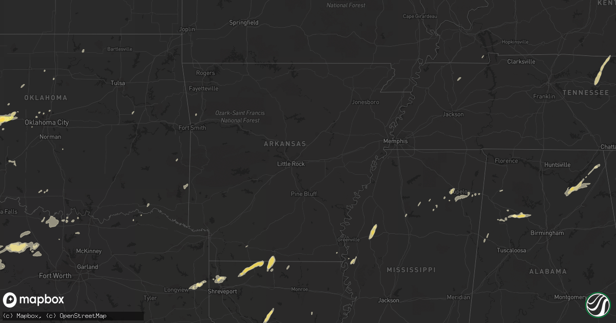
Hail Map in Arkansas on October 12, 2014
Get this storm
October 12 map
$229
one time, instant access
Download today. No call, no setup
Keep the $229
Bought the map and want the full workflow? Apply the entire $229 to a subscription within 7 days. None of it is wasted.
Every map, not just this one
This buys you this map. Subscription and you get every map we run, in the markets you choose from a few cities to whole states to nationwide. Plus real-time alerts the moment a storm fires.
Contact data
Name, contact info, occupancy, even credit band for addresses in the footprint. You go from where it hit to who to call.
Become the source they trust
Unlimited branding weather history reports on demand. You already have the documented answer ready for the property owner, and you are the one who showed up with it.
Property data and RoofTrace estimates
Pull up any address you have got, its value and the exact code rules for that jurisdiction, straight from One Click Code. Then RoofTrace estimates the squares, pitch, and roof value, priced the way you price.
Storm reports in Arkansas
Arkansas
| Date | Description |
|---|---|
| 10/12/20146:50 AM CDT | Trees were blown down in the southeastern portion of the county. |
| 10/12/20146:40 AM CDT | A local report indicates 60 MPH wind near 6 S JASPER |
| 10/12/20146:35 AM CDT | Several trees down in the area...including one tree that fell on a house. |
| 10/12/20146:30 AM CDT | A tree was blown down. |
| 10/12/20146:10 AM CDT | Limbs were blown down. |
| 10/12/20145:56 AM CDT | Trees down across highways 70... 41 south and hwy 24... Power out for 1200 people |
| 10/12/20145:43 AM CDT | An ef0 tornado briefly touched down just south of cr 108...where it snapped a number of trees and destroyed a barn. The estimated peak winds were 65-75 mph. The tornado |
| 10/12/20145:37 AM CDT | *** 1 fatal... 4 inj *** an ef2 tornado touched down just south of the arden community near highway 32... Where it snapped an uprooted numerous trees. The tornado then de (sh |
| 10/12/20145:21 AM CDT | Preliminary rating of ef1. Uprooted numerous trees. Snapped a few hardwood trunks. Minor damage...mostly shingles...to a couple of homes. Destroyed a couple of outbuild |
| 10/12/20145:12 AM CDT | Trees were blown down. |
| 10/12/20145:10 AM CDT | Trees blocking roadway around county roads 8378 and 8340 |
| 10/12/20145:10 AM CDT | Trees and power lines were blown down. |
| 10/12/20145:04 AM CDT | Nws storm survey revealed an ef1 tornado with peak winds of 100-110 mph and max width of 300 yds. A pole barn was destroyed...along with trees and power lines blown dow |
| 10/12/201412:10 AM CDT | A roof was blown off a classroom building and landed on a nearby roof. |
All States Impacted by Hail Map on October 12, 2014
Cities Impacted by Hail Map on October 12, 2014
- Hobart, OK
- Roosevelt, OK
- Olney, TX
- Newcastle, TX
- Loving, TX
- Graham, TX
- Edmond, OK
- Oklahoma City, OK
- Arapaho, OK
- Thomas, OK
- Weatherford, OK
- Clinton, OK
- Goodrich, TX
- New Caney, TX
- Livingston, TX
- Splendora, TX
- Chester, TX
- Shepherd, TX
- Dayton, TX
- Cleveland, TX
- Buffalo, OK
- Ashland, KS
- Wanette, OK
- Lexington, OK
- Blanket, TX
- Coldwater, KS
- Colorado City, TX
- Robert Lee, TX
- Follett, TX
- Henagar, AL
- Pisgah, AL
- Ider, AL
- Dutton, AL
- Flat Rock, AL
- Section, AL
- Bend, TX
- Lampasas, TX
- Lometa, TX
- San Saba, TX
- Fluvanna, TX
- Walters, OK
- Glen Allan, MS
- Shamrock, TX
- Wellington, TX
- Texola, OK
- Erick, OK
- Mustang, OK
- Yukon, OK
- Watonga, OK
- Nettleton, MS
- Anson, TX
- Stamford, TX
- Lueders, TX
- Avoca, TX
- Bowie, TX
- Jacksboro, TX
- Bryson, TX
- Vardaman, MS
- Bridgeport, TX
- Paradise, TX
- Jayton, TX
- Rotan, TX
- Snyder, TX
- Aspermont, TX
- Goldsboro, TX
- Novice, TX
- Winters, TX
- Benton, LA
- Shreveport, LA
- Voss, TX
- Ballinger, TX
- Wingate, TX
- Bronte, TX
- Geary, OK
- Calumet, OK
- Paducah, TX
- Seymour, TX
- Knox City, TX
- Old Glory, TX
- Decatur, TX
- Weinert, TX
- Munday, TX
- Hennessey, OK
- Meade, KS
- Watson, OK
- Eudora, AR
- Protection, KS
- Electra, TX
- Ira, TX
- Groveoak, AL
- Crossville, AL
- Albertville, AL
- Horton, AL
- Guntersville, AL
- Alvord, TX
- Chico, TX
- Goree, TX
- Colony, OK
- Cordell, OK
- Wilmore, KS
- Norton, TX
- Carter, OK
- Elk City, OK
- Dawson, AL
- Englewood, KS
- Dodson, LA
- Winnfield, LA
- Homer, LA
- Shongaloo, LA
- Cotton Valley, LA
- Haynesville, LA
- Minden, LA
- Burbank, OK
- Canute, OK
- Lone Wolf, OK
- Hinton, OK
- Dill City, OK
- Foss, OK
- Willow, OK
- Bessie, OK
- Hydro, OK
- Corn, OK
- Sentinel, OK
- Humble, TX
- Kingwood, TX
- Porter, TX
- O'Brien, TX
- Rochester, TX
- Big Spring, TX
- Abilene, TX
- Hooker, OK
- Tupelo, MS
- Pontotoc, MS
- Belden, MS
- Woodson, TX
- Throckmorton, TX
- Plains, KS
- Fyffe, AL
- Collinsville, AL
- Geraldine, AL
- Many, LA
- Jasper, TX
- Newton, TX
- Wiergate, TX
- Hemphill, TX
- Florien, LA
- Hallettsville, TX
- Rule, TX
- Sunflower, MS
- Powderly, TX
- Breckenridge, TX
- Graford, TX
- South Bend, TX
- Carbon Hill, AL
- Oakman, AL
- Jasper, AL
- Townley, AL
- Forgan, OK
- Gate, OK
- Turpin, OK
- Kismet, KS
- Liberal, KS
- Davidson, OK
- Hermleigh, TX
- Rolling Fork, MS
- Hollandale, MS
- Carlsbad, TX
- Gainesboro, TN
- Whitleyville, TN
- Bernice, LA
- Spearsville, LA
- Lillie, LA
- Junction City, AR
- El Dorado, AR
- Granville, TN
- Bloomington Springs, TN
- Buffalo Valley, TN
- Baxter, TN
- Merkel, TX
- Tioga, TX
- Collinsville, TX
- Gunter, TX
- Waco, TX
- China Spring, TX
- Crawford, TX
- Woodway, TX
- Grandfield, OK
- Sumner, TX
- Bellevue, TX
- Coahoma, TX
- Garwood, TX
- Edna, TX
- Copperas Cove, TX
- Sweetwater, TX
- Celina, TN
- Saint Jo, TX
- Nocona, TX
- Rising Star, TX
- Tremont, MS
- Marion, LA
- Canadian, TX
- Gainesville, TX
- Thackerville, OK
- Marshall, TX
- Karnack, TX
- Whitesboro, TX
- Aimwell, LA
- Harrisonburg, LA
- Altus, OK
- Fulton, MS
- Roscoe, TX
- Nolan, TX
- Miles, TX
- San Angelo, TX
- Reform, AL
- Millport, AL
- Gotebo, OK
- Mountain View, OK
- Rudy, AR
- Muenster, TX
- Lindsay, TX
- Oklaunion, TX
- Burkesville, KY
- Tompkinsville, KY
- Silver Point, TN
- Hilham, TN
- Moss, TN
- Doddsville, MS
- Indianola, MS
- Moorhead, MS
- Sadler, TX
- Mooringsport, LA
- Belcher, LA
- Anguilla, MS
- Roby, TX
- Bear Creek, AL
- Hackleburg, AL
- Ranger, TX
- Eastland, TX
- Crowell, TX
- Blackwell, TX
- Fayette, AL
- Bankston, AL
- Boynton, OK
- Hugoton, KS
- Albany, TX
- Fletcher, OK
- Lawton, OK
- Elgin, OK
- Marthaville, LA
- Berry, AL
- Cordova, AL
- Rusk, TX
- Jacksonville, TX
- Plantersville, MS
- Shannon, MS
- Okolona, MS
- Greenfield, TN
- Gleason, TN
- Dresden, TN
- Headrick, OK
- Blair, OK
- Olustee, OK
- Coffeeville, MS
- Grenada, MS
- Ethelsville, AL
- Jermyn, TX
- Oakwood, TX
- Ovalo, TX
- Lawn, TX
- Clyde, TX
- Covington, OK
- Bruce, MS
- Chillicothe, TX
- Vernon, TX
- Gail, TX
- Healdton, OK
- Sawyer, OK
- Colmesneil, TX
- Woodville, TX
- Perrin, TX
- Harrold, TX
- Sanger, TX
- Perry, OK
- Ringling, OK
- Strawn, TX
- Murray, KY
- Magnolia, AR
- Westbrook, TX
- Haskell, TX
- Sylvester, TX
- Oglesby, TX
- McGregor, TX
- Houlka, MS
- Hodgen, OK
- Eldridge, AL
- Mayersville, MS
- Winnsboro, LA
- Lookeba, OK
- Butler, OK
- Gatesville, TX


