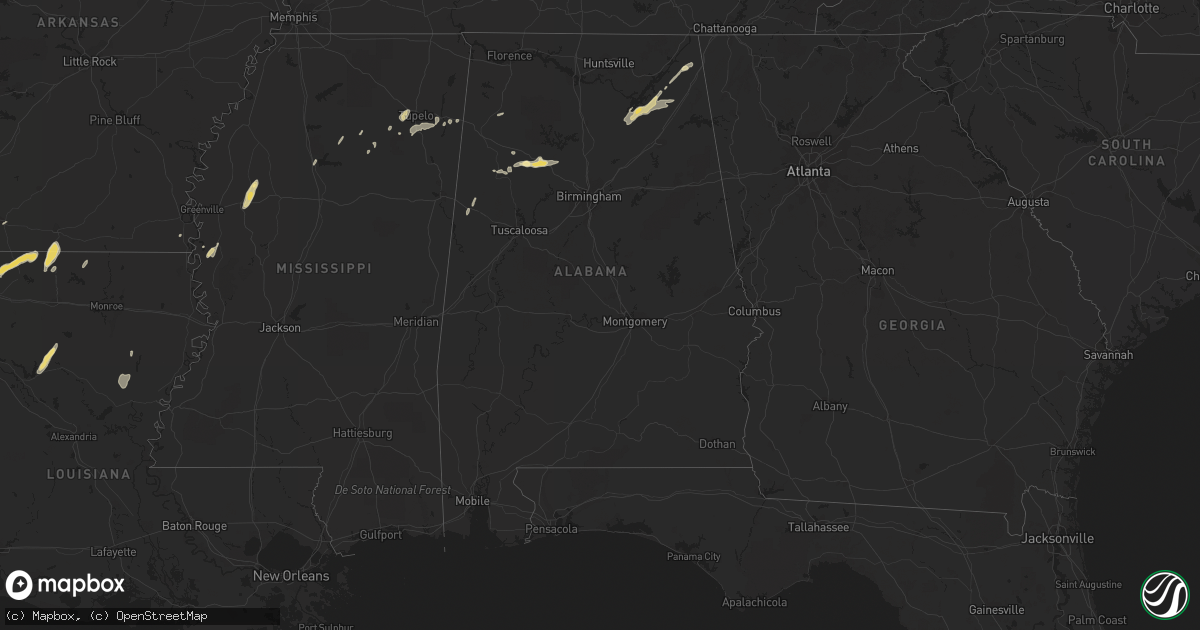
Hail Map in Alabama on October 12, 2014
Get this storm
October 12 map
$229
one time, instant access
Download today. No call, no setup
Keep the $229
Bought the map and want the full workflow? Apply the entire $229 to a subscription within 7 days. None of it is wasted.
Every map, not just this one
This buys you this map. Subscription and you get every map we run, in the markets you choose from a few cities to whole states to nationwide. Plus real-time alerts the moment a storm fires.
Contact data
Name, contact info, occupancy, even credit band for addresses in the footprint. You go from where it hit to who to call.
Become the source they trust
Unlimited branding weather history reports on demand. You already have the documented answer ready for the property owner, and you are the one who showed up with it.
Property data and RoofTrace estimates
Pull up any address you have got, its value and the exact code rules for that jurisdiction, straight from One Click Code. Then RoofTrace estimates the squares, pitch, and roof value, priced the way you price.
Storm reports in Alabama
Alabama
| Date | Description |
|---|---|
| 10/12/20146:05 PM CDT | Updated...several trees down across west jasper including along airport rd. Dime size hail also reported near the intersection of old hwy 78 and airport rd. |
| 10/12/20145:45 PM CDT | One tree down along hwy 102 near turtle hole rd. Hail was falling at the time of the report...size unknown. |
| 10/12/20144:07 PM CDT | Quarter sized hail and a large tree down near the intersection of rose road and goodwin road in albertville. |
| 10/12/201412:45 PM CDT | Thunderstorm winds knocked power lines down onto a home. |
| 10/12/201412:45 PM CDT | Thunderstorm winds knocked trees down on south seneca road. |
| 10/11/20148:49 PM CDT | Quarter sized hail was reported near the intersection of highway 75 and cr 117. |
All States Impacted by Hail Map on October 12, 2014
Cities Impacted by Hail Map on October 12, 2014
- Hobart, OK
- Roosevelt, OK
- Olney, TX
- Newcastle, TX
- Loving, TX
- Graham, TX
- Edmond, OK
- Oklahoma City, OK
- Arapaho, OK
- Thomas, OK
- Weatherford, OK
- Clinton, OK
- Goodrich, TX
- New Caney, TX
- Livingston, TX
- Splendora, TX
- Chester, TX
- Shepherd, TX
- Dayton, TX
- Cleveland, TX
- Buffalo, OK
- Ashland, KS
- Wanette, OK
- Lexington, OK
- Blanket, TX
- Coldwater, KS
- Colorado City, TX
- Robert Lee, TX
- Follett, TX
- Henagar, AL
- Pisgah, AL
- Ider, AL
- Dutton, AL
- Flat Rock, AL
- Section, AL
- Bend, TX
- Lampasas, TX
- Lometa, TX
- San Saba, TX
- Fluvanna, TX
- Walters, OK
- Glen Allan, MS
- Shamrock, TX
- Wellington, TX
- Texola, OK
- Erick, OK
- Mustang, OK
- Yukon, OK
- Watonga, OK
- Nettleton, MS
- Anson, TX
- Stamford, TX
- Lueders, TX
- Avoca, TX
- Bowie, TX
- Jacksboro, TX
- Bryson, TX
- Vardaman, MS
- Bridgeport, TX
- Paradise, TX
- Jayton, TX
- Rotan, TX
- Snyder, TX
- Aspermont, TX
- Goldsboro, TX
- Novice, TX
- Winters, TX
- Benton, LA
- Shreveport, LA
- Voss, TX
- Ballinger, TX
- Wingate, TX
- Bronte, TX
- Geary, OK
- Calumet, OK
- Paducah, TX
- Seymour, TX
- Knox City, TX
- Old Glory, TX
- Decatur, TX
- Weinert, TX
- Munday, TX
- Hennessey, OK
- Meade, KS
- Watson, OK
- Eudora, AR
- Protection, KS
- Electra, TX
- Ira, TX
- Groveoak, AL
- Crossville, AL
- Albertville, AL
- Horton, AL
- Guntersville, AL
- Alvord, TX
- Chico, TX
- Goree, TX
- Colony, OK
- Cordell, OK
- Wilmore, KS
- Norton, TX
- Carter, OK
- Elk City, OK
- Dawson, AL
- Englewood, KS
- Dodson, LA
- Winnfield, LA
- Homer, LA
- Shongaloo, LA
- Cotton Valley, LA
- Haynesville, LA
- Minden, LA
- Burbank, OK
- Canute, OK
- Lone Wolf, OK
- Hinton, OK
- Dill City, OK
- Foss, OK
- Willow, OK
- Bessie, OK
- Hydro, OK
- Corn, OK
- Sentinel, OK
- Humble, TX
- Kingwood, TX
- Porter, TX
- O'Brien, TX
- Rochester, TX
- Big Spring, TX
- Abilene, TX
- Hooker, OK
- Tupelo, MS
- Pontotoc, MS
- Belden, MS
- Woodson, TX
- Throckmorton, TX
- Plains, KS
- Fyffe, AL
- Collinsville, AL
- Geraldine, AL
- Many, LA
- Jasper, TX
- Newton, TX
- Wiergate, TX
- Hemphill, TX
- Florien, LA
- Hallettsville, TX
- Rule, TX
- Sunflower, MS
- Powderly, TX
- Breckenridge, TX
- Graford, TX
- South Bend, TX
- Carbon Hill, AL
- Oakman, AL
- Jasper, AL
- Townley, AL
- Forgan, OK
- Gate, OK
- Turpin, OK
- Kismet, KS
- Liberal, KS
- Davidson, OK
- Hermleigh, TX
- Rolling Fork, MS
- Hollandale, MS
- Carlsbad, TX
- Gainesboro, TN
- Whitleyville, TN
- Bernice, LA
- Spearsville, LA
- Lillie, LA
- Junction City, AR
- El Dorado, AR
- Granville, TN
- Bloomington Springs, TN
- Buffalo Valley, TN
- Baxter, TN
- Merkel, TX
- Tioga, TX
- Collinsville, TX
- Gunter, TX
- Waco, TX
- China Spring, TX
- Crawford, TX
- Woodway, TX
- Grandfield, OK
- Sumner, TX
- Bellevue, TX
- Coahoma, TX
- Garwood, TX
- Edna, TX
- Copperas Cove, TX
- Sweetwater, TX
- Celina, TN
- Saint Jo, TX
- Nocona, TX
- Rising Star, TX
- Tremont, MS
- Marion, LA
- Canadian, TX
- Gainesville, TX
- Thackerville, OK
- Marshall, TX
- Karnack, TX
- Whitesboro, TX
- Aimwell, LA
- Harrisonburg, LA
- Altus, OK
- Fulton, MS
- Roscoe, TX
- Nolan, TX
- Miles, TX
- San Angelo, TX
- Reform, AL
- Millport, AL
- Gotebo, OK
- Mountain View, OK
- Rudy, AR
- Muenster, TX
- Lindsay, TX
- Oklaunion, TX
- Burkesville, KY
- Tompkinsville, KY
- Silver Point, TN
- Hilham, TN
- Moss, TN
- Doddsville, MS
- Indianola, MS
- Moorhead, MS
- Sadler, TX
- Mooringsport, LA
- Belcher, LA
- Anguilla, MS
- Roby, TX
- Bear Creek, AL
- Hackleburg, AL
- Ranger, TX
- Eastland, TX
- Crowell, TX
- Blackwell, TX
- Fayette, AL
- Bankston, AL
- Boynton, OK
- Hugoton, KS
- Albany, TX
- Fletcher, OK
- Lawton, OK
- Elgin, OK
- Marthaville, LA
- Berry, AL
- Cordova, AL
- Rusk, TX
- Jacksonville, TX
- Plantersville, MS
- Shannon, MS
- Okolona, MS
- Greenfield, TN
- Gleason, TN
- Dresden, TN
- Headrick, OK
- Blair, OK
- Olustee, OK
- Coffeeville, MS
- Grenada, MS
- Ethelsville, AL
- Jermyn, TX
- Oakwood, TX
- Ovalo, TX
- Lawn, TX
- Clyde, TX
- Covington, OK
- Bruce, MS
- Chillicothe, TX
- Vernon, TX
- Gail, TX
- Healdton, OK
- Sawyer, OK
- Colmesneil, TX
- Woodville, TX
- Perrin, TX
- Harrold, TX
- Sanger, TX
- Perry, OK
- Ringling, OK
- Strawn, TX
- Murray, KY
- Magnolia, AR
- Westbrook, TX
- Haskell, TX
- Sylvester, TX
- Oglesby, TX
- McGregor, TX
- Houlka, MS
- Hodgen, OK
- Eldridge, AL
- Mayersville, MS
- Winnsboro, LA
- Lookeba, OK
- Butler, OK
- Gatesville, TX


