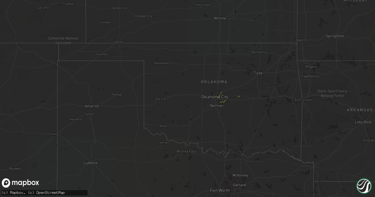
Hail Map in Oklahoma on October 9, 2018
Get this storm
October 9 map
$229
one time, instant access
Download today. No call, no setup
Keep the $229
Bought the map and want the full workflow? Apply the entire $229 to a subscription within 7 days. None of it is wasted.
Every map, not just this one
This buys you this map. Subscription and you get every map we run, in the markets you choose from a few cities to whole states to nationwide. Plus real-time alerts the moment a storm fires.
Contact data
Name, contact info, occupancy, even credit band for addresses in the footprint. You go from where it hit to who to call.
Become the source they trust
Unlimited branding weather history reports on demand. You already have the documented answer ready for the property owner, and you are the one who showed up with it.
Property data and RoofTrace estimates
Pull up any address you have got, its value and the exact code rules for that jurisdiction, straight from One Click Code. Then RoofTrace estimates the squares, pitch, and roof value, priced the way you price.
Storm reports in Oklahoma
Oklahoma
| Date | Description |
|---|---|
| 10/09/20181:10 PM CDT | Thunderstorm wind destroyed a couple barns |
| 10/09/201812:15 PM CDT | The roof of a wood-framed outbuilding was damaged |
| 10/09/201812:10 PM CDT | Strong thunderstorm wind damaged the roof of a home |
| 10/09/201812:02 PM CDT | Strong thunderstorm wind snapped large tree limbs |
| 10/09/201811:27 AM CDT | Large tree limb and privacy fence blown down near liberty elementary. Report relayed via social media. |
| 10/09/201811:26 AM CDT | Large tree limb blown down at e 41st and s 193rd. Report received via social media. |
| 10/09/201811:17 AM CDT | Tree blown down at e 101st and s 129th. Report via social media. |
| 10/09/201811:15 AM CDT | Report relayed via social media. |
| 10/09/201810:00 AM CDT | Multiple tree branches broken |
| 10/09/20189:50 AM CDT | Large tree blown down |
| 10/09/20189:33 AM CDT | Car overturned and outbuilding damaged. Time estimated from radar. |
| 10/09/20189:04 AM CDT | Large grain bin blown over. |
| 10/09/20188:42 AM CDT | Large tree down with bus hut blown over on harrah road south of 119th. Time is radar estimate. |
| 10/09/20188:42 AM CDT | Roofs blown off buildings from apparent tornado. Time estimated from radar. |
| 10/09/20188:36 AM CDT | Tornado observed near intersection of 144th ave and deer creek rd. Time estimated from radar. |
| 10/09/20188:32 AM CDT | Roof and structural damage to homes. Time estimated from radar. |
| 10/09/20188:31 AM CDT | Roofs taken off building near the intersection of national ave and republic circle. |
| 10/09/20188:29 AM CDT | Cars overturned in parking lot near intersection of 29th st and air depot rd. Time estimated from radar. |
| 10/09/20188:29 AM CDT | Power poles downed... Possible tornado. |
| 10/09/20188:24 AM CDT | 59mph gust measured at ardmore asos |
| 10/09/20188:11 AM CDT | Roof blown off a residence... As well as exentsive damage to another residence. Trees and power lines also down. |
| 10/09/20187:16 AM CDT | At 1216 PM CDT, severe thunderstorms were located along a line extending from 4 miles northeast of Tiawah to 3 miles northwest of Hulbert, moving northeast at 40 mph. HAZARD...60 mph wind gusts. SOURCE...Radar indicated. IMPACT...Expect damage to roofs, siding, and trees. Locations in or near the path include... Claremore... Pryor... Pryor Creek... Chouteau... Locust Grove... Salina... Langley... Adair... Hulbert... Ketchum... Spavinaw... Disney... Oaks... Big Cabin... Pensacola... Hoot Owl... Peggs... Cherokee State Park... Rose... Leach...This includes Interstate 44 between mile markers 248 and 277. |
| 10/09/20186:54 AM CDT | At 1153 AM CDT, severe thunderstorms were located along a line extending from near Oologah to 6 miles northeast of Oneta to 4 miles south of Wagoner, moving northeast at 40 mph. HAZARD...60 mph wind gusts. SOURCE...Radar indicated. IMPACT...Expect damage to roofs, siding, and trees. Locations in or near the path include... Broken Arrow... Claremore... Wagoner... Owasso... Coweta... Catoosa... Verdigris... Chouteau... Inola... Oologah... Porter... Foyil... Tullahassee... Taiwah... Tiawah... Oneta... Redbird... Mazie... Bushyhead... This includes Interstate 44 between mile markers 234 and 260. |
| 10/09/20186:10 AM CDT | At 1109 AM CDT, severe thunderstorms were located along a line extending from 3 miles east of Sand Springs to 5 miles south of Council Hill, moving northeast at 35 mph. HAZARD...60 mph wind gusts. SOURCE...Radar indicated. IMPACT...Expect damage to roofs, siding, and trees. Locations in or near the path include... Tulsa... Broken Arrow... Muskogee... Sand Springs... Claremore... Wagoner... Owasso... Bixby... Jenks... Glenpool... Coweta... Catoosa... Collinsville... Fort Gibson... Verdigris... Haskell... Inola... Morris... Oologah... Okay...This includes the following highways, Interstate 40 in Oklahoma near mile marker 247. Interstate 44 between mile markers 217 and 260. |
| 10/09/20186:04 AM CDT | At 1104 AM CDT, severe thunderstorms were located along a line extending from 5 miles southwest of Barnsdall to 5 miles west of Sperry to 4 miles south of Turley, moving northeast at 40 mph. HAZARD...60 mph wind gusts. SOURCE...Radar indicated. IMPACT...Expect damage to roofs, siding, and trees. Locations in or near the path include... Tulsa... Bartlesville... Skiatook... Collinsville... Dewey... Barnsdall... Sperry... Ramona... Ochelata... Avant... Talala... Vera... Bartlesville Municipal Airport... Turley... Okesa... Watova... Tallant... Wolco... |
| 10/09/20185:31 AM CDT | At 1030 AM CDT, severe thunderstorms were located along a line extending from 4 miles northwest of Kellyville to 5 miles northeast of Dustin, moving northeast at 40 mph. HAZARD...60 mph wind gusts. SOURCE...Radar indicated. IMPACT...Expect damage to roofs, siding, and trees. Locations in or near the path include... Tulsa... Broken Arrow... Sand Springs... Okmulgee... Bristow... Bixby... Sapulpa... Jenks... Okfuskee... Glenpool... Henryetta... Kiefer... Morris... Beggs... Mounds... Kellyville... Weleetka... Dewar... Schulter... Boynton...This includes the following highways, Interstate 40 in Oklahoma between mile markers 224 and 250. Interstate 44 between mile markers 191 and 224. |
| 10/09/20185:23 AM CDT | At 1023 AM CDT, severe thunderstorms were located along a line extending from 4 miles southeast of Terlton to 5 miles south of Mannford to 6 miles northwest of Kellyville, moving north at 35 mph. HAZARD...60 mph wind gusts. SOURCE...Radar indicated. IMPACT...Expect damage to roofs, siding, and trees. Locations in or near the path include... Hominy... Mannford... Westport... Osage... Keystone State Park... Walnut Creek State Park... |
| 10/09/20184:29 AM CDT | At 928 AM CDT, severe thunderstorms were located along a line extending from near Agra to 4 miles east of Sasakwa, moving northeast at 40 mph. HAZARD...60 mph wind gusts. SOURCE...Radar indicated. IMPACT...Expect damage to roofs, siding, and trees. Locations in or near the path include... Bristow... Okemah... Okfuskee... Drumright... Boley... Weleetka... Depew... Paden... Bearden... Slick... Castle... Shamrock... Clearview... Welty... Pharoah... Milfay... Mason... This includes the following highways, Interstate 40 in Oklahoma between mile markers 212 and 231. Interstate 44 between mile markers 178 and 197. |
| 10/09/20184:29 AM CDT | At 929 AM CDT, severe thunderstorms were located along a line extending from 3 miles southeast of Lucien to 5 miles east of Perkins to near Davenport to 3 miles southwest of Prague to 5 miles north of Sasakwa, moving northeast at 45 mph. HAZARD...70 mph wind gusts. SOURCE...Radar indicated. IMPACT...Expect considerable tree damage. Damage is likely to mobile homes, roofs, and outbuildings. Locations impacted include... Stillwater, Ponca City, Cushing, Seminole, Holdenville, Perry, Chandler, Wewoka, Perkins, Stroud, Prague, Wetumka, Yale, Davenport, Morrison, Glencoe, Tryon, Bowlegs, Ripley and Dustin. |
| 10/09/20184:01 AM CDT | At 901 AM CDT, severe thunderstorms were located along a line extending from 6 miles northeast of Vanoss to near Fittstown to near Nida to near Cartwright, moving east at 45 mph. HAZARD...70 mph wind gusts. SOURCE...Radar indicated. IMPACT...Expect considerable tree damage. Damage is likely to mobile homes, roofs, and outbuildings. Locations impacted include... Ada, Durant, Atoka, Coalgate, Byng, Colbert, Caddo, Allen, Bokchito, Achille, Stonewall, Wapanucka, Stringtown, Lehigh, Bennington, Silo, Tupelo, Milburn, Francis and Tushka. |
| 10/09/20183:47 AM CDT | At 847 AM CDT, severe thunderstorms were located along a line extending from 3 miles south of Lovell to 3 miles southeast of Cedar Valley to 4 miles north of Arcadia, moving northeast at 45 mph. HAZARD...60 mph wind gusts. SOURCE...Radar indicated. IMPACT...Expect damage to roofs, siding, and trees. Locations impacted include... Stillwater, Guthrie, Cushing, Perry, Perkins, Langston, Crescent, Carney, Tryon, Ripley, Agra, Coyle, Cedar Valley, Marshall, Mulhall, Cimarron City, Orlando, Meridian, Lake Mcmurtry and Lovell. |
| 10/09/20183:30 AM CDT | At 830 AM CDT, severe thunderstorms were located along a line extending from near Oklahoma City to 3 miles east of Rosedale, moving northeast at 40 mph. HAZARD...70 mph wind gusts. SOURCE...Radar indicated. IMPACT...Expect considerable tree damage. Damage is likely to mobile homes, roofs, and outbuildings. Locations impacted include... Eastern Edmond, Shawnee, Seminole, Tecumseh, Chandler, Choctaw, Harrah, McLoud, Wewoka, Jones, Nicoma Park, Prague, Pink, Konawa, Luther, Meeker, Maud, Davenport, Wellston and Earlsboro. |
| 10/09/20183:15 AM CDT | At 814 AM CDT, severe thunderstorms were located along a line extending from near Piedmont to near Oklahoma City to near Purcell, moving north at 20 mph. Low level rotation is being observed just southwest of downtown Oklahoma City. HAZARD...70 mph wind gusts. SOURCE...Radar indicated. IMPACT...Expect considerable tree damage. Damage is likely to mobile homes, roofs, and outbuildings. Locations impacted include... Oklahoma City, Norman, Edmond, Moore, Midwest City, Del City, Purcell, Yukon, Bethany, Choctaw, Warr Acres, The Village, Noble, Piedmont, Slaughterville, Spencer, Nichols Hills, Nicoma Park, Lexington and Goldsby. |
Cities Impacted by Hail Map on October 9, 2018
- Hawks, MI
- Berlin, WI
- Eastman, WI
- Mineral Point, WI
- Dodgeville, WI
- Elkton, MI
- Portage, WI
- Oxford, WI
- Montello, WI
- Rogers City, MI
- Alpena, MI
- Posen, MI
- Lachine, MI
- Utopia, TX
- Vanderpool, TX
- Endeavor, WI
- Baraboo, WI
- Merrimac, WI
- Wautoma, WI
- La Grange, TX
- Poy Sippi, WI
- Neshkoro, WI
- Redgranite, WI
- Pine River, WI
- Fremont, WI
- Winneconne, WI
- Larsen, WI
- Omro, WI
- Llano, TX
- Princeton, WI
- Rio Frio, TX
- Concan, TX
- Leakey, TX
- Gays Mills, WI
- Steuben, WI
- Wauzeka, WI
- Hortonville, WI
- Waupaca, WI
- Wild Rose, WI
- Almond, WI
- Belmont, WI
- Ridgeway, WI
- Darlington, WI
- Cuba City, WI
- Rocksprings, TX
- Millersburg, MI
- Medina, TX
- Kerrville, TX
- Alice, TX
- Centerville, TX
- Wisconsin Dells, WI
- Briggsville, WI
- Prairie Du Chien, WI
- Onaway, MI
- Ganado, TX
- Edna, TX
- Kewaunee, WI
- Gonzales, TX
- Waelder, TX
- Garwood, TX
- Santa Elena, TX
- Packwaukee, WI
- Tivoli, TX
- Refugio, TX
- Buchanan Dam, TX
- Uvalde, TX
- Eagle Lake, TX
- Cuero, TX
- Giddings, TX
- Spencer, OK
- Oklahoma City, OK
- Jones, OK
- Newalla, OK
- Norman, OK
- Mcloud, OK
- Prague, OK
- Westfield, WI


