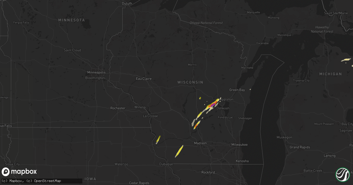
Hail Map in Wisconsin on October 9, 2018
Get this storm
October 9 map
$229
one time, instant access
Download today. No call, no setup
Keep the $229
Bought the map and want the full workflow? Apply the entire $229 to a subscription within 7 days. None of it is wasted.
Every map, not just this one
This buys you this map. Subscription and you get every map we run, in the markets you choose from a few cities to whole states to nationwide. Plus real-time alerts the moment a storm fires.
Contact data
Name, contact info, occupancy, even credit band for addresses in the footprint. You go from where it hit to who to call.
Become the source they trust
Unlimited branding weather history reports on demand. You already have the documented answer ready for the property owner, and you are the one who showed up with it.
Property data and RoofTrace estimates
Pull up any address you have got, its value and the exact code rules for that jurisdiction, straight from One Click Code. Then RoofTrace estimates the squares, pitch, and roof value, priced the way you price.
Storm reports in Wisconsin
Wisconsin
| Date | Description |
|---|---|
| 10/09/20186:35 PM CDT | A local report indicates 60 MPH wind near 1 NNE FOX LAKE |
| 10/09/20186:18 PM CDT | Quarter size hail on the north side of lake poygan. |
| 10/09/20186:05 PM CDT | Report received via social media |
| 10/09/20184:53 PM CDT | A local report indicates 1.50 inch wind near 3 NW PORTAGE |
| 10/09/20183:57 PM CDT | Barn down and power lines down. |
| 10/09/20182:50 PM CDT | A local report indicates 1.00 inch wind near MINERAL POINT |
| 10/09/20181:52 AM CDT | At 652 PM CDT, severe thunderstorms were located along a line extending from near Waupun to near Markesan, moving north at 40 mph. HAZARD...60 mph wind gusts and penny size hail. SOURCE...Radar indicated. IMPACT...Expect damage to roofs, siding, and trees. Locations impacted include... Waupun, Ripon, Berlin, Markesan, Rosendale, Green Lake, Brandon, Alto, Manchester, Fairwater and West Rosendale. |
| 10/09/20181:14 AM CDT | At 614 PM CDT, a severe thunderstorm was located near Columbus, moving north at 40 mph. HAZARD...60 mph wind gusts and penny size hail. SOURCE...Radar indicated. IMPACT...Expect damage to roofs, siding, and trees. Locations impacted include... Beaver Dam, Columbus, Randolph, Fall River, Cambria, Fox Lake, Otsego, Friesland, Doylestown, East Bristol, Astico, Danville, South Beaver Dam and Leipsig. |
| 10/09/201812:54 AM CDT | At 553 PM CDT, a severe thunderstorm was located near Redgranite, or 8 miles north of Berlin, moving northeast at 30 mph. HAZARD...60 mph wind gusts and quarter size hail. SOURCE...Radar indicated. IMPACT...Hail damage to vehicles is expected. Expect wind damage to roofs, siding, and trees. Locations impacted include... Berlin, Redgranite, Lake Poygan, Winneconne, Lohrville, Larsen, Orihula, Auroraville, Borth and Zittau. |
| 10/09/201812:12 AM CDT | At 511 PM CDT, a severe thunderstorm was located 5 miles southwest of Wautoma, moving northeast at 40 mph. HAZARD...60 mph wind gusts and quarter size hail. SOURCE...Radar indicated. IMPACT...Hail damage to vehicles is expected. Expect wind damage to roofs, siding, and trees. Locations impacted include... Wautoma, Redgranite, Silver Lake, Pine River, Dakota, Mount Morris, Saxeville, Wild Rose, Spring Lake and Lohrville. |
| 10/09/201812:07 AM CDT | At 506 PM CDT, a severe thunderstorm was located 7 miles north of Portage, moving northeast at 20 mph. HAZARD...60 mph wind gusts and half dollar size hail. SOURCE...Radar indicated. IMPACT...Hail damage to vehicles is expected. Expect wind damage to roofs, siding, and trees. Locations impacted include... Montello and Glen Oak. |
| 10/08/201811:47 PM CDT | At 447 PM CDT, a severe thunderstorm was located over Portage, moving northeast at 30 mph. HAZARD...60 mph wind gusts and quarter size hail. SOURCE...Radar indicated. IMPACT...Hail damage to vehicles is expected. Expect wind damage to roofs, siding, and trees. Locations impacted include... Portage. |
| 10/08/201811:36 PM CDT | At 436 PM CDT, a severe thunderstorm was located 9 miles east of Prairie Du Chien, moving northeast at 30 mph. HAZARD...60 mph wind gusts and half dollar size hail. SOURCE...Radar indicated. IMPACT...Hail damage to vehicles is expected. Expect wind damage to roofs, siding, and trees. This severe thunderstorm will remain over mainly rural areas of central Crawford County, including the following locations... Seneca, Wauzeka, Gays Mills, Eastman and Mount Sterling. |
| 10/08/20189:54 PM CDT | At 254 PM CDT, a severe thunderstorm was located over Mineral Point, moving northeast at 30 mph. HAZARD...Golf ball size hail and 60 mph wind gusts. SOURCE...Radar indicated. IMPACT...People and animals outdoors will be injured. Expect hail damage to roofs, siding, windows, and vehicles. Expect wind damage to roofs, siding, and trees. Locations impacted include... Dodgeville, Barneveld, Arena, Ridgeway and Governor Dodge St Park. |
| 10/08/20189:46 PM CDT | At 246 PM CDT, a severe thunderstorm was located near Balltown, or 11 miles south of Lancaster, moving northeast at 25 mph. HAZARD...60 mph wind gusts and quarter size hail. SOURCE...Radar indicated. IMPACT...Hail damage to vehicles is expected. Expect wind damage to roofs, siding, and trees. This severe thunderstorm will be near... Dickeyville around 255 PM CDT. Lancaster around 315 PM CDT. Platteville around 325 PM CDT.Other locations impacted by this severe thunderstorm include Arthur,Montfort, Potosi, Livingston and Ellenboro. |
| 10/08/20189:31 PM CDT | At 230 PM CDT, a severe thunderstorm was located near Belmont, or 8 miles northwest of Darlington, moving northeast at 30 mph. HAZARD...60 mph wind gusts and penny size hail. SOURCE...Radar indicated. IMPACT...Expect damage to roofs, siding, and trees. Locations impacted include... Mineral Point, Belmont and Linden. |
Cities Impacted by Hail Map on October 9, 2018
- Hawks, MI
- Berlin, WI
- Eastman, WI
- Mineral Point, WI
- Dodgeville, WI
- Elkton, MI
- Portage, WI
- Oxford, WI
- Montello, WI
- Rogers City, MI
- Alpena, MI
- Posen, MI
- Lachine, MI
- Utopia, TX
- Vanderpool, TX
- Endeavor, WI
- Baraboo, WI
- Merrimac, WI
- Wautoma, WI
- La Grange, TX
- Poy Sippi, WI
- Neshkoro, WI
- Redgranite, WI
- Pine River, WI
- Fremont, WI
- Winneconne, WI
- Larsen, WI
- Omro, WI
- Llano, TX
- Princeton, WI
- Rio Frio, TX
- Concan, TX
- Leakey, TX
- Gays Mills, WI
- Steuben, WI
- Wauzeka, WI
- Hortonville, WI
- Waupaca, WI
- Wild Rose, WI
- Almond, WI
- Belmont, WI
- Ridgeway, WI
- Darlington, WI
- Cuba City, WI
- Rocksprings, TX
- Millersburg, MI
- Medina, TX
- Kerrville, TX
- Alice, TX
- Centerville, TX
- Wisconsin Dells, WI
- Briggsville, WI
- Prairie Du Chien, WI
- Onaway, MI
- Ganado, TX
- Edna, TX
- Kewaunee, WI
- Gonzales, TX
- Waelder, TX
- Garwood, TX
- Santa Elena, TX
- Packwaukee, WI
- Tivoli, TX
- Refugio, TX
- Buchanan Dam, TX
- Uvalde, TX
- Eagle Lake, TX
- Cuero, TX
- Giddings, TX
- Spencer, OK
- Oklahoma City, OK
- Jones, OK
- Newalla, OK
- Norman, OK
- Mcloud, OK
- Prague, OK
- Westfield, WI


