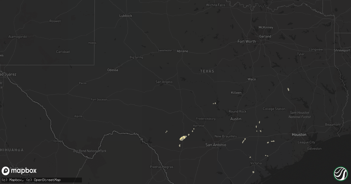
Hail Map in Texas on October 9, 2018
Get this storm
October 9 map
$229
one time, instant access
Download today. No call, no setup
Keep the $229
Bought the map and want the full workflow? Apply the entire $229 to a subscription within 7 days. None of it is wasted.
Every map, not just this one
This buys you this map. Subscription and you get every map we run, in the markets you choose from a few cities to whole states to nationwide. Plus real-time alerts the moment a storm fires.
Contact data
Name, contact info, occupancy, even credit band for addresses in the footprint. You go from where it hit to who to call.
Become the source they trust
Unlimited branding weather history reports on demand. You already have the documented answer ready for the property owner, and you are the one who showed up with it.
Property data and RoofTrace estimates
Pull up any address you have got, its value and the exact code rules for that jurisdiction, straight from One Click Code. Then RoofTrace estimates the squares, pitch, and roof value, priced the way you price.
Storm reports in Texas
Texas
| Date | Description |
|---|---|
| 10/09/20188:38 AM CDT | Delayed report----a video from local officials showed a brief tornado west of the intersection of simpson road and hwy 317. |
| 10/09/20188:26 AM CDT | Delayed report: tornado on the ground crossing hwy 317 just north of crawford. |
| 10/09/20183:18 AM CDT | At 817 AM CDT, severe thunderstorms were located along a line extending from near Paoli to near Lebanon, moving northeast at 40 mph. HAZARD...70 mph wind gusts. SOURCE...Law enforcement. IMPACT...Expect considerable tree damage. Damage is likely to mobile homes, roofs, and outbuildings. Locations impacted include... Ardmore, Pauls Valley, Sulphur, Madill, Tishomingo, Davis, Marietta, Wynnewood, Kingston, Stratford, Dickson, Mannsville, Roff, Springer, Paoli, Ravia, Mill Creek, Milburn, Byars and Fitzhugh. |
| 10/09/20182:28 AM CDT | At 727 AM CDT, a severe thunderstorm was located over Rio Frio, or 7 miles south of Leakey, moving northeast at 20 mph. HAZARD...60 mph wind gusts and quarter size hail. SOURCE...Radar indicated. IMPACT...Hail damage to vehicles is expected. Expect wind damage to roofs, siding, and trees. Locations impacted include... Leakey, Vanderpool, Tuff, Garner State Park, Rio Frio, Reagan Wells, Utopia, Concan and Lost Maples State Natural Area. |
| 10/09/20181:28 AM CDT | At 628 AM CDT, a severe thunderstorm was located over Montell, or 22 miles southwest of Leakey, moving east at 30 mph. HAZARD...60 mph wind gusts and quarter size hail. SOURCE...Radar indicated. IMPACT...Hail damage to vehicles is expected. Expect wind damage to roofs, siding, and trees. Locations impacted include... Laguna, Reagan Wells, Concan, Montell, Garner State Park, and Rio Frio. |
| 10/09/201812:13 AM CDT | At 512 AM CDT, a severe thunderstorm was located over Alamo Village, or 9 miles north of Brackettville, moving east at 25 mph. HAZARD...70 mph wind gusts and quarter size hail. SOURCE...Radar indicated. IMPACT...Hail damage to vehicles is expected. Expect considerable tree damage. Wind damage is also likely to mobile homes, roofs, and outbuildings. Locations impacted include... Alamo Village. |
| 10/08/201811:50 PM CDT | At 449 AM CDT, a severe thunderstorm was located near Standart, or 7 miles west of Brackettville, moving east at 30 mph. HAZARD...70 mph wind gusts and ping pong ball size hail. SOURCE...Radar indicated. IMPACT...People and animals outdoors will be injured. Expect hail damage to roofs, siding, windows, and vehicles. Expect considerable tree damage. Wind damage is also likely to mobile homes, roofs, and outbuildings. Locations impacted include... Brackettville, Spofford, Anacacho, Turkey Mountain and Fort Clark Springs. |
| 10/08/201811:12 PM CDT | At 412 AM CDT, a severe thunderstorm was located near Amanda, or 11 miles east of Del Rio, moving northeast at 20 mph. HAZARD...70 mph wind gusts and quarter size hail. SOURCE...Radar indicated. IMPACT...Hail damage to vehicles is expected. Expect considerable tree damage. Wind damage is also likely to mobile homes, roofs, and outbuildings. Locations impacted include... Standart, Alamo Village, Amanda, Laughlin AFB and Kickapoo Cavern State Park. |
| 10/08/201810:16 PM CDT | At 315 AM CDT, a severe thunderstorm was located 13 miles south of Telegraph, or 20 miles northeast of Rocksprings, moving northeast at 25 mph. HAZARD...60 mph wind gusts and nickel size hail. SOURCE...Radar indicated. IMPACT...Expect damage to roofs, siding, and trees. Locations impacted include... Us-83 Near The Kerr-Kimble County Line. |
| 10/08/201810:10 PM CDT | At 309 AM CDT, a severe thunderstorm was located near Del Rio, moving northeast at 20 mph. HAZARD...70 mph wind gusts and quarter size hail. SOURCE...Radar indicated. IMPACT...Hail damage to vehicles is expected. Expect considerable tree damage. Wind damage is also likely to mobile homes, roofs, and outbuildings. Locations impacted include... Del Rio, Standart, Cienegas Terrace, Amanda, Laughlin AFB and Val Verde Park. |
Cities Impacted by Hail Map on October 9, 2018
- Hawks, MI
- Berlin, WI
- Eastman, WI
- Mineral Point, WI
- Dodgeville, WI
- Elkton, MI
- Portage, WI
- Oxford, WI
- Montello, WI
- Rogers City, MI
- Alpena, MI
- Posen, MI
- Lachine, MI
- Utopia, TX
- Vanderpool, TX
- Endeavor, WI
- Baraboo, WI
- Merrimac, WI
- Wautoma, WI
- La Grange, TX
- Poy Sippi, WI
- Neshkoro, WI
- Redgranite, WI
- Pine River, WI
- Fremont, WI
- Winneconne, WI
- Larsen, WI
- Omro, WI
- Llano, TX
- Princeton, WI
- Rio Frio, TX
- Concan, TX
- Leakey, TX
- Gays Mills, WI
- Steuben, WI
- Wauzeka, WI
- Hortonville, WI
- Waupaca, WI
- Wild Rose, WI
- Almond, WI
- Belmont, WI
- Ridgeway, WI
- Darlington, WI
- Cuba City, WI
- Rocksprings, TX
- Millersburg, MI
- Medina, TX
- Kerrville, TX
- Alice, TX
- Centerville, TX
- Wisconsin Dells, WI
- Briggsville, WI
- Prairie Du Chien, WI
- Onaway, MI
- Ganado, TX
- Edna, TX
- Kewaunee, WI
- Gonzales, TX
- Waelder, TX
- Garwood, TX
- Santa Elena, TX
- Packwaukee, WI
- Tivoli, TX
- Refugio, TX
- Buchanan Dam, TX
- Uvalde, TX
- Eagle Lake, TX
- Cuero, TX
- Giddings, TX
- Spencer, OK
- Oklahoma City, OK
- Jones, OK
- Newalla, OK
- Norman, OK
- Mcloud, OK
- Prague, OK
- Westfield, WI


