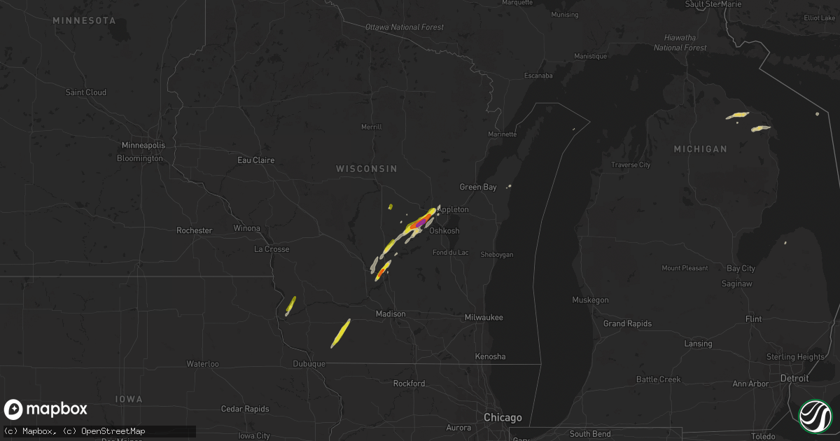
Hail Map on October 9, 2018
Get this storm
October 9 map
$229
one time, instant access
Download today. No call, no setup
Keep the $229
Bought the map and want the full workflow? Apply the entire $229 to a subscription within 7 days. None of it is wasted.
Every map, not just this one
This buys you this map. Subscription and you get every map we run, in the markets you choose from a few cities to whole states to nationwide. Plus real-time alerts the moment a storm fires.
Contact data
Name, contact info, occupancy, even credit band for addresses in the footprint. You go from where it hit to who to call.
Become the source they trust
Unlimited branding weather history reports on demand. You already have the documented answer ready for the property owner, and you are the one who showed up with it.
Property data and RoofTrace estimates
Pull up any address you have got, its value and the exact code rules for that jurisdiction, straight from One Click Code. Then RoofTrace estimates the squares, pitch, and roof value, priced the way you price.
Storm reports
Arkansas
| Date | Description |
|---|---|
| 10/09/20183:40 PM CDT | Tornado briefly touched down in western johnson county. |
| 10/09/20183:38 PM CDT | There is video confirmation of a tornado... Along with minor damage southwest of hunt. Part of a roof was removed from a storage building along county road 3010... With |
| 10/09/20183:20 PM CDT | Single family home damaged... Along with downed trees in altus. Event time radar estimated. |
| 10/09/20187:54 AM CDT | At 1253 PM CDT, severe thunderstorms were located along a line extending from 4 miles south of Edna to 3 miles northeast of Rose, moving northeast at 35 mph. HAZARD...60 mph wind gusts. SOURCE...Radar indicated. IMPACT...Expect damage to roofs, siding, and trees. Locations in or near the path include... Miami... Vinita... Baxter Springs... Jay... Grove... Commerce... Gravette... Fairland... Afton... Quapaw... Langley... Colcord... Kansas... Welch... Bernice... Ketchum... Spavinaw... Bluejacket... Wyandotte... Disney...This includes Interstate 44 between mile markers 281 and 324. |
| 10/08/201810:58 PM CDT | At 358 PM CDT, a severe thunderstorm was located 7 miles east of Cass, moving north at 35 mph. HAZARD...60 mph wind gusts. SOURCE...Radar indicated. IMPACT...Expect damage to roofs, siding, and trees. Locations in or near the path include... St. Paul... Pettigrew... Boston... Dutton... Red Star... Redding... Taft... |
Oklahoma
| Date | Description |
|---|---|
| 10/09/20181:10 PM CDT | Thunderstorm wind destroyed a couple barns |
| 10/09/201812:15 PM CDT | The roof of a wood-framed outbuilding was damaged |
| 10/09/201812:10 PM CDT | Strong thunderstorm wind damaged the roof of a home |
| 10/09/201812:02 PM CDT | Strong thunderstorm wind snapped large tree limbs |
| 10/09/201811:27 AM CDT | Large tree limb and privacy fence blown down near liberty elementary. Report relayed via social media. |
| 10/09/201811:26 AM CDT | Large tree limb blown down at e 41st and s 193rd. Report received via social media. |
| 10/09/201811:17 AM CDT | Tree blown down at e 101st and s 129th. Report via social media. |
| 10/09/201811:15 AM CDT | Report relayed via social media. |
| 10/09/201810:00 AM CDT | Multiple tree branches broken |
| 10/09/20189:50 AM CDT | Large tree blown down |
| 10/09/20189:33 AM CDT | Car overturned and outbuilding damaged. Time estimated from radar. |
| 10/09/20189:04 AM CDT | Large grain bin blown over. |
| 10/09/20188:42 AM CDT | Large tree down with bus hut blown over on harrah road south of 119th. Time is radar estimate. |
| 10/09/20188:42 AM CDT | Roofs blown off buildings from apparent tornado. Time estimated from radar. |
| 10/09/20188:36 AM CDT | Tornado observed near intersection of 144th ave and deer creek rd. Time estimated from radar. |
| 10/09/20188:32 AM CDT | Roof and structural damage to homes. Time estimated from radar. |
| 10/09/20188:31 AM CDT | Roofs taken off building near the intersection of national ave and republic circle. |
| 10/09/20188:29 AM CDT | Cars overturned in parking lot near intersection of 29th st and air depot rd. Time estimated from radar. |
| 10/09/20188:29 AM CDT | Power poles downed... Possible tornado. |
| 10/09/20188:24 AM CDT | 59mph gust measured at ardmore asos |
| 10/09/20188:11 AM CDT | Roof blown off a residence... As well as exentsive damage to another residence. Trees and power lines also down. |
| 10/09/20187:16 AM CDT | At 1216 PM CDT, severe thunderstorms were located along a line extending from 4 miles northeast of Tiawah to 3 miles northwest of Hulbert, moving northeast at 40 mph. HAZARD...60 mph wind gusts. SOURCE...Radar indicated. IMPACT...Expect damage to roofs, siding, and trees. Locations in or near the path include... Claremore... Pryor... Pryor Creek... Chouteau... Locust Grove... Salina... Langley... Adair... Hulbert... Ketchum... Spavinaw... Disney... Oaks... Big Cabin... Pensacola... Hoot Owl... Peggs... Cherokee State Park... Rose... Leach...This includes Interstate 44 between mile markers 248 and 277. |
| 10/09/20186:54 AM CDT | At 1153 AM CDT, severe thunderstorms were located along a line extending from near Oologah to 6 miles northeast of Oneta to 4 miles south of Wagoner, moving northeast at 40 mph. HAZARD...60 mph wind gusts. SOURCE...Radar indicated. IMPACT...Expect damage to roofs, siding, and trees. Locations in or near the path include... Broken Arrow... Claremore... Wagoner... Owasso... Coweta... Catoosa... Verdigris... Chouteau... Inola... Oologah... Porter... Foyil... Tullahassee... Taiwah... Tiawah... Oneta... Redbird... Mazie... Bushyhead... This includes Interstate 44 between mile markers 234 and 260. |
| 10/09/20186:10 AM CDT | At 1109 AM CDT, severe thunderstorms were located along a line extending from 3 miles east of Sand Springs to 5 miles south of Council Hill, moving northeast at 35 mph. HAZARD...60 mph wind gusts. SOURCE...Radar indicated. IMPACT...Expect damage to roofs, siding, and trees. Locations in or near the path include... Tulsa... Broken Arrow... Muskogee... Sand Springs... Claremore... Wagoner... Owasso... Bixby... Jenks... Glenpool... Coweta... Catoosa... Collinsville... Fort Gibson... Verdigris... Haskell... Inola... Morris... Oologah... Okay...This includes the following highways, Interstate 40 in Oklahoma near mile marker 247. Interstate 44 between mile markers 217 and 260. |
| 10/09/20186:04 AM CDT | At 1104 AM CDT, severe thunderstorms were located along a line extending from 5 miles southwest of Barnsdall to 5 miles west of Sperry to 4 miles south of Turley, moving northeast at 40 mph. HAZARD...60 mph wind gusts. SOURCE...Radar indicated. IMPACT...Expect damage to roofs, siding, and trees. Locations in or near the path include... Tulsa... Bartlesville... Skiatook... Collinsville... Dewey... Barnsdall... Sperry... Ramona... Ochelata... Avant... Talala... Vera... Bartlesville Municipal Airport... Turley... Okesa... Watova... Tallant... Wolco... |
| 10/09/20185:31 AM CDT | At 1030 AM CDT, severe thunderstorms were located along a line extending from 4 miles northwest of Kellyville to 5 miles northeast of Dustin, moving northeast at 40 mph. HAZARD...60 mph wind gusts. SOURCE...Radar indicated. IMPACT...Expect damage to roofs, siding, and trees. Locations in or near the path include... Tulsa... Broken Arrow... Sand Springs... Okmulgee... Bristow... Bixby... Sapulpa... Jenks... Okfuskee... Glenpool... Henryetta... Kiefer... Morris... Beggs... Mounds... Kellyville... Weleetka... Dewar... Schulter... Boynton...This includes the following highways, Interstate 40 in Oklahoma between mile markers 224 and 250. Interstate 44 between mile markers 191 and 224. |
| 10/09/20185:23 AM CDT | At 1023 AM CDT, severe thunderstorms were located along a line extending from 4 miles southeast of Terlton to 5 miles south of Mannford to 6 miles northwest of Kellyville, moving north at 35 mph. HAZARD...60 mph wind gusts. SOURCE...Radar indicated. IMPACT...Expect damage to roofs, siding, and trees. Locations in or near the path include... Hominy... Mannford... Westport... Osage... Keystone State Park... Walnut Creek State Park... |
| 10/09/20184:29 AM CDT | At 928 AM CDT, severe thunderstorms were located along a line extending from near Agra to 4 miles east of Sasakwa, moving northeast at 40 mph. HAZARD...60 mph wind gusts. SOURCE...Radar indicated. IMPACT...Expect damage to roofs, siding, and trees. Locations in or near the path include... Bristow... Okemah... Okfuskee... Drumright... Boley... Weleetka... Depew... Paden... Bearden... Slick... Castle... Shamrock... Clearview... Welty... Pharoah... Milfay... Mason... This includes the following highways, Interstate 40 in Oklahoma between mile markers 212 and 231. Interstate 44 between mile markers 178 and 197. |
| 10/09/20184:29 AM CDT | At 929 AM CDT, severe thunderstorms were located along a line extending from 3 miles southeast of Lucien to 5 miles east of Perkins to near Davenport to 3 miles southwest of Prague to 5 miles north of Sasakwa, moving northeast at 45 mph. HAZARD...70 mph wind gusts. SOURCE...Radar indicated. IMPACT...Expect considerable tree damage. Damage is likely to mobile homes, roofs, and outbuildings. Locations impacted include... Stillwater, Ponca City, Cushing, Seminole, Holdenville, Perry, Chandler, Wewoka, Perkins, Stroud, Prague, Wetumka, Yale, Davenport, Morrison, Glencoe, Tryon, Bowlegs, Ripley and Dustin. |
| 10/09/20184:01 AM CDT | At 901 AM CDT, severe thunderstorms were located along a line extending from 6 miles northeast of Vanoss to near Fittstown to near Nida to near Cartwright, moving east at 45 mph. HAZARD...70 mph wind gusts. SOURCE...Radar indicated. IMPACT...Expect considerable tree damage. Damage is likely to mobile homes, roofs, and outbuildings. Locations impacted include... Ada, Durant, Atoka, Coalgate, Byng, Colbert, Caddo, Allen, Bokchito, Achille, Stonewall, Wapanucka, Stringtown, Lehigh, Bennington, Silo, Tupelo, Milburn, Francis and Tushka. |
| 10/09/20183:47 AM CDT | At 847 AM CDT, severe thunderstorms were located along a line extending from 3 miles south of Lovell to 3 miles southeast of Cedar Valley to 4 miles north of Arcadia, moving northeast at 45 mph. HAZARD...60 mph wind gusts. SOURCE...Radar indicated. IMPACT...Expect damage to roofs, siding, and trees. Locations impacted include... Stillwater, Guthrie, Cushing, Perry, Perkins, Langston, Crescent, Carney, Tryon, Ripley, Agra, Coyle, Cedar Valley, Marshall, Mulhall, Cimarron City, Orlando, Meridian, Lake Mcmurtry and Lovell. |
| 10/09/20183:30 AM CDT | At 830 AM CDT, severe thunderstorms were located along a line extending from near Oklahoma City to 3 miles east of Rosedale, moving northeast at 40 mph. HAZARD...70 mph wind gusts. SOURCE...Radar indicated. IMPACT...Expect considerable tree damage. Damage is likely to mobile homes, roofs, and outbuildings. Locations impacted include... Eastern Edmond, Shawnee, Seminole, Tecumseh, Chandler, Choctaw, Harrah, McLoud, Wewoka, Jones, Nicoma Park, Prague, Pink, Konawa, Luther, Meeker, Maud, Davenport, Wellston and Earlsboro. |
| 10/09/20183:15 AM CDT | At 814 AM CDT, severe thunderstorms were located along a line extending from near Piedmont to near Oklahoma City to near Purcell, moving north at 20 mph. Low level rotation is being observed just southwest of downtown Oklahoma City. HAZARD...70 mph wind gusts. SOURCE...Radar indicated. IMPACT...Expect considerable tree damage. Damage is likely to mobile homes, roofs, and outbuildings. Locations impacted include... Oklahoma City, Norman, Edmond, Moore, Midwest City, Del City, Purcell, Yukon, Bethany, Choctaw, Warr Acres, The Village, Noble, Piedmont, Slaughterville, Spencer, Nichols Hills, Nicoma Park, Lexington and Goldsby. |
Texas
| Date | Description |
|---|---|
| 10/09/20188:38 AM CDT | Delayed report----a video from local officials showed a brief tornado west of the intersection of simpson road and hwy 317. |
| 10/09/20188:26 AM CDT | Delayed report: tornado on the ground crossing hwy 317 just north of crawford. |
| 10/09/20183:18 AM CDT | At 817 AM CDT, severe thunderstorms were located along a line extending from near Paoli to near Lebanon, moving northeast at 40 mph. HAZARD...70 mph wind gusts. SOURCE...Law enforcement. IMPACT...Expect considerable tree damage. Damage is likely to mobile homes, roofs, and outbuildings. Locations impacted include... Ardmore, Pauls Valley, Sulphur, Madill, Tishomingo, Davis, Marietta, Wynnewood, Kingston, Stratford, Dickson, Mannsville, Roff, Springer, Paoli, Ravia, Mill Creek, Milburn, Byars and Fitzhugh. |
| 10/09/20182:28 AM CDT | At 727 AM CDT, a severe thunderstorm was located over Rio Frio, or 7 miles south of Leakey, moving northeast at 20 mph. HAZARD...60 mph wind gusts and quarter size hail. SOURCE...Radar indicated. IMPACT...Hail damage to vehicles is expected. Expect wind damage to roofs, siding, and trees. Locations impacted include... Leakey, Vanderpool, Tuff, Garner State Park, Rio Frio, Reagan Wells, Utopia, Concan and Lost Maples State Natural Area. |
| 10/09/20181:28 AM CDT | At 628 AM CDT, a severe thunderstorm was located over Montell, or 22 miles southwest of Leakey, moving east at 30 mph. HAZARD...60 mph wind gusts and quarter size hail. SOURCE...Radar indicated. IMPACT...Hail damage to vehicles is expected. Expect wind damage to roofs, siding, and trees. Locations impacted include... Laguna, Reagan Wells, Concan, Montell, Garner State Park, and Rio Frio. |
| 10/09/201812:13 AM CDT | At 512 AM CDT, a severe thunderstorm was located over Alamo Village, or 9 miles north of Brackettville, moving east at 25 mph. HAZARD...70 mph wind gusts and quarter size hail. SOURCE...Radar indicated. IMPACT...Hail damage to vehicles is expected. Expect considerable tree damage. Wind damage is also likely to mobile homes, roofs, and outbuildings. Locations impacted include... Alamo Village. |
| 10/08/201811:50 PM CDT | At 449 AM CDT, a severe thunderstorm was located near Standart, or 7 miles west of Brackettville, moving east at 30 mph. HAZARD...70 mph wind gusts and ping pong ball size hail. SOURCE...Radar indicated. IMPACT...People and animals outdoors will be injured. Expect hail damage to roofs, siding, windows, and vehicles. Expect considerable tree damage. Wind damage is also likely to mobile homes, roofs, and outbuildings. Locations impacted include... Brackettville, Spofford, Anacacho, Turkey Mountain and Fort Clark Springs. |
| 10/08/201811:12 PM CDT | At 412 AM CDT, a severe thunderstorm was located near Amanda, or 11 miles east of Del Rio, moving northeast at 20 mph. HAZARD...70 mph wind gusts and quarter size hail. SOURCE...Radar indicated. IMPACT...Hail damage to vehicles is expected. Expect considerable tree damage. Wind damage is also likely to mobile homes, roofs, and outbuildings. Locations impacted include... Standart, Alamo Village, Amanda, Laughlin AFB and Kickapoo Cavern State Park. |
| 10/08/201810:16 PM CDT | At 315 AM CDT, a severe thunderstorm was located 13 miles south of Telegraph, or 20 miles northeast of Rocksprings, moving northeast at 25 mph. HAZARD...60 mph wind gusts and nickel size hail. SOURCE...Radar indicated. IMPACT...Expect damage to roofs, siding, and trees. Locations impacted include... Us-83 Near The Kerr-Kimble County Line. |
| 10/08/201810:10 PM CDT | At 309 AM CDT, a severe thunderstorm was located near Del Rio, moving northeast at 20 mph. HAZARD...70 mph wind gusts and quarter size hail. SOURCE...Radar indicated. IMPACT...Hail damage to vehicles is expected. Expect considerable tree damage. Wind damage is also likely to mobile homes, roofs, and outbuildings. Locations impacted include... Del Rio, Standart, Cienegas Terrace, Amanda, Laughlin AFB and Val Verde Park. |
Missouri
| Date | Description |
|---|---|
| 10/09/20184:25 PM CDT | Delayed report...minor tree damage. |
| 10/09/20184:22 PM CDT | Brief touchdown near spickard. |
| 10/09/20184:05 PM CDT | Delayed report...minor tree damage. |
| 10/09/20183:06 PM CDT | From social media. Large tree down across secondary roadway. |
| 10/09/20182:58 PM CDT | A local report indicates a tornado near 4 NNW KNOXVILLE |
| 10/09/20182:21 PM CDT | Picture via social media of car port roof torn off near the intersection of central city rd and w 7th st. Just west of joplin. Joplin airport asos also measured a 49mph |
Florida
| Date | Description |
|---|---|
| 10/09/20189:22 AM CDT | An emergency manager relayed a report of a small pine tree down on us 1 at north old kings road that was blocking one lane of us 1. |
| 10/09/20185:15 AM CDT | At 1014 AM EDT, a severe thunderstorm was located over Oceanway, or near Jacksonville International Arpt, moving west at 40 mph. HAZARD...60 mph wind gusts. SOURCE...Radar indicated. IMPACT...Expect damage to roofs, siding, and trees. Locations impacted include... Callahan, Jacksonville International Arpt, Ratliff, Oceanway and Nassau Village-Ratliff. |
Maine
| Date | Description |
|---|---|
| 10/09/20186:01 AM CDT | At 1100 PM EDT, a severe thunderstorm was located near Russel Crossing, or 11 miles southwest of Portage, moving southeast at 40 mph. HAZARD...60 mph wind gusts. SOURCE...Radar indicated. IMPACT...Damage to trees and power lines. Locations impacted include... Presque Isle, Houlton, Mapleton, Mars Hill, Ashland, Easton, Bridgewater, Portage Lake, Masardis, Oxbow, Russel Crossing, Big Machias Lake, Scopan, Nashville Plantation, Dudley Township, Littleton, Monticello, Blaine, Westfield and Chapman. |
Kansas
| Date | Description |
|---|---|
| 10/09/20183:40 PM CDT | Delayed report...time-matched to radar. Multiple limbs down... Shingles off garage... And tin shed roof blown off. Eyewitness confirmed that strong winds persisted for |
| 10/09/20187:22 AM CDT | At 1221 PM CDT, a severe thunderstorm was located over Dearing, or near Coffeyville, moving north at 50 mph. HAZARD...60 mph wind gusts. SOURCE...Radar indicated. IMPACT...Expect damage to roofs, siding, and trees. Locations impacted include... Coffeyville, Independence, Cherryvale, Dearing, Liberty, Sycamore, Coffeyville Airport and Independence Airport. |
| 10/09/20187:11 AM CDT | At 1210 PM CDT, severe thunderstorms were located along a line extending from 3 miles south of Tyro to 4 miles north of Foyil, moving northeast at 35 mph. HAZARD...60 mph wind gusts. SOURCE...Radar indicated. IMPACT...Expect damage to roofs, siding, and trees. Locations in or near the path include... Vinita... Nowata... Chelsea... South Coffeyville... Delaware... Lenapah... Wann... New Alluwe... White Oak... Hollow... Centrailia... Pyramid Corners... Centralia... Bushyhead...This includes Interstate 44 between mile markers 277 and 289. |
| 10/09/20186:37 AM CDT | At 1137 AM CDT, severe thunderstorms were located along a line extending from 2 miles south of Chautauqua to Collinsville, moving northeast at 30 mph. HAZARD...60 mph wind gusts. SOURCE...Radar indicated. IMPACT...Expect damage to roofs, siding, and trees. Locations in or near the path include... Bartlesville... Nowata... Skiatook... Collinsville... Dewey... Copan... Ramona... Ochelata... Delaware... Lenapah... Talala... Vera... Wann... Bartlesville Municipal Airport... Hulah... Watova... Wah Sha She State Park... |
| 10/09/20185:55 AM CDT | At 1054 AM CDT, severe thunderstorms were located along a line extending from 9 miles southeast of Shidler to 6 miles west of Pawhuska to 2 miles northwest of Wynona to 6 miles west of Barnsdall, moving northeast at 30 mph. HAZARD...60 mph wind gusts. SOURCE...Radar indicated. IMPACT...Expect damage to roofs, siding, and trees. Locations in or near the path include... Pawhuska... Wynona... Bigheart... Osage Hills State Park... Pearsonia... Hulah... Sunset Lake... Pershing... Wah Sha She State Park... Nelagoney... |
| 10/08/20188:12 PM CDT | At 112 PM CDT, a severe thunderstorm was located 6 miles east of Edna, or 7 miles southeast of Altamont, moving north at 35 mph. HAZARD...60 mph wind gusts. SOURCE...Radar indicated. IMPACT...Expect damage to roofs, siding, and trees. Locations impacted include... Parsons, Oswego, Chetopa, Altamont, Bartlett, Labette and Dennis. |
Iowa
| Date | Description |
|---|---|
| 10/09/20186:22 PM CDT | Brief rope tornado. |
| 10/09/20185:42 PM CDT | Tornado on the ground in zion... Ia. |
| 10/09/20185:30 PM CDT | Reported at 3717 w. Gresham road cedar falls... Ia. Roof damage to farm building... Powerlines down. |
| 10/09/20184:59 PM CDT | Em relays report of tornado on ground from law enforcement. |
| 10/09/20184:55 PM CDT | Em relayed the report from law enforcement. |
| 10/09/20184:53 PM CDT | Tornado reported looking north from highway e36 just east of clutier. Delayed report. Report via social media. |
| 10/09/20184:21 PM CDT | Tornado reported off to the north northeast from the mm 186 on i-80 in poweshiek county. |
| 10/09/20184:20 PM CDT | Report via social media. |
| 10/09/20184:19 PM CDT | Trained spotter reports tornado about 5 miles north-north east of hwy 146 and 350th ave. |
| 10/09/20183:48 PM CDT | Ef0 brief touchdown observed in field by broadcast meteorologist. No damage observed. Tornado lasted less than 30 seconds. |
| 10/09/20183:34 PM CDT | Brief touchdown reported. |
| 10/09/20183:30 PM CDT | Funnel cloud with multiple brief touchdowns in the vicinity of centerville. |
| 10/09/20183:25 PM CDT | Funnel cloud touching down briefly reported via social media and phone call. |
| 10/09/20183:21 PM CDT | Emergency manager reported tornado damage at the centerville municipal airport. Unknown extent at the time. Time estimated from radar. |
Wisconsin
| Date | Description |
|---|---|
| 10/09/20186:35 PM CDT | A local report indicates 60 MPH wind near 1 NNE FOX LAKE |
| 10/09/20186:18 PM CDT | Quarter size hail on the north side of lake poygan. |
| 10/09/20186:05 PM CDT | Report received via social media |
| 10/09/20184:53 PM CDT | A local report indicates 1.50 inch wind near 3 NW PORTAGE |
| 10/09/20183:57 PM CDT | Barn down and power lines down. |
| 10/09/20182:50 PM CDT | A local report indicates 1.00 inch wind near MINERAL POINT |
| 10/09/20181:52 AM CDT | At 652 PM CDT, severe thunderstorms were located along a line extending from near Waupun to near Markesan, moving north at 40 mph. HAZARD...60 mph wind gusts and penny size hail. SOURCE...Radar indicated. IMPACT...Expect damage to roofs, siding, and trees. Locations impacted include... Waupun, Ripon, Berlin, Markesan, Rosendale, Green Lake, Brandon, Alto, Manchester, Fairwater and West Rosendale. |
| 10/09/20181:14 AM CDT | At 614 PM CDT, a severe thunderstorm was located near Columbus, moving north at 40 mph. HAZARD...60 mph wind gusts and penny size hail. SOURCE...Radar indicated. IMPACT...Expect damage to roofs, siding, and trees. Locations impacted include... Beaver Dam, Columbus, Randolph, Fall River, Cambria, Fox Lake, Otsego, Friesland, Doylestown, East Bristol, Astico, Danville, South Beaver Dam and Leipsig. |
| 10/09/201812:54 AM CDT | At 553 PM CDT, a severe thunderstorm was located near Redgranite, or 8 miles north of Berlin, moving northeast at 30 mph. HAZARD...60 mph wind gusts and quarter size hail. SOURCE...Radar indicated. IMPACT...Hail damage to vehicles is expected. Expect wind damage to roofs, siding, and trees. Locations impacted include... Berlin, Redgranite, Lake Poygan, Winneconne, Lohrville, Larsen, Orihula, Auroraville, Borth and Zittau. |
| 10/09/201812:12 AM CDT | At 511 PM CDT, a severe thunderstorm was located 5 miles southwest of Wautoma, moving northeast at 40 mph. HAZARD...60 mph wind gusts and quarter size hail. SOURCE...Radar indicated. IMPACT...Hail damage to vehicles is expected. Expect wind damage to roofs, siding, and trees. Locations impacted include... Wautoma, Redgranite, Silver Lake, Pine River, Dakota, Mount Morris, Saxeville, Wild Rose, Spring Lake and Lohrville. |
| 10/09/201812:07 AM CDT | At 506 PM CDT, a severe thunderstorm was located 7 miles north of Portage, moving northeast at 20 mph. HAZARD...60 mph wind gusts and half dollar size hail. SOURCE...Radar indicated. IMPACT...Hail damage to vehicles is expected. Expect wind damage to roofs, siding, and trees. Locations impacted include... Montello and Glen Oak. |
| 10/08/201811:47 PM CDT | At 447 PM CDT, a severe thunderstorm was located over Portage, moving northeast at 30 mph. HAZARD...60 mph wind gusts and quarter size hail. SOURCE...Radar indicated. IMPACT...Hail damage to vehicles is expected. Expect wind damage to roofs, siding, and trees. Locations impacted include... Portage. |
| 10/08/201811:36 PM CDT | At 436 PM CDT, a severe thunderstorm was located 9 miles east of Prairie Du Chien, moving northeast at 30 mph. HAZARD...60 mph wind gusts and half dollar size hail. SOURCE...Radar indicated. IMPACT...Hail damage to vehicles is expected. Expect wind damage to roofs, siding, and trees. This severe thunderstorm will remain over mainly rural areas of central Crawford County, including the following locations... Seneca, Wauzeka, Gays Mills, Eastman and Mount Sterling. |
| 10/08/20189:54 PM CDT | At 254 PM CDT, a severe thunderstorm was located over Mineral Point, moving northeast at 30 mph. HAZARD...Golf ball size hail and 60 mph wind gusts. SOURCE...Radar indicated. IMPACT...People and animals outdoors will be injured. Expect hail damage to roofs, siding, windows, and vehicles. Expect wind damage to roofs, siding, and trees. Locations impacted include... Dodgeville, Barneveld, Arena, Ridgeway and Governor Dodge St Park. |
| 10/08/20189:46 PM CDT | At 246 PM CDT, a severe thunderstorm was located near Balltown, or 11 miles south of Lancaster, moving northeast at 25 mph. HAZARD...60 mph wind gusts and quarter size hail. SOURCE...Radar indicated. IMPACT...Hail damage to vehicles is expected. Expect wind damage to roofs, siding, and trees. This severe thunderstorm will be near... Dickeyville around 255 PM CDT. Lancaster around 315 PM CDT. Platteville around 325 PM CDT.Other locations impacted by this severe thunderstorm include Arthur,Montfort, Potosi, Livingston and Ellenboro. |
| 10/08/20189:31 PM CDT | At 230 PM CDT, a severe thunderstorm was located near Belmont, or 8 miles northwest of Darlington, moving northeast at 30 mph. HAZARD...60 mph wind gusts and penny size hail. SOURCE...Radar indicated. IMPACT...Expect damage to roofs, siding, and trees. Locations impacted include... Mineral Point, Belmont and Linden. |
Cities Impacted by Hail Map on October 9, 2018
- Hawks, MI
- Berlin, WI
- Eastman, WI
- Mineral Point, WI
- Dodgeville, WI
- Elkton, MI
- Portage, WI
- Oxford, WI
- Montello, WI
- Rogers City, MI
- Alpena, MI
- Posen, MI
- Lachine, MI
- Utopia, TX
- Vanderpool, TX
- Endeavor, WI
- Baraboo, WI
- Merrimac, WI
- Wautoma, WI
- La Grange, TX
- Poy Sippi, WI
- Neshkoro, WI
- Redgranite, WI
- Pine River, WI
- Fremont, WI
- Winneconne, WI
- Larsen, WI
- Omro, WI
- Llano, TX
- Princeton, WI
- Rio Frio, TX
- Concan, TX
- Leakey, TX
- Gays Mills, WI
- Steuben, WI
- Wauzeka, WI
- Hortonville, WI
- Waupaca, WI
- Wild Rose, WI
- Almond, WI
- Belmont, WI
- Ridgeway, WI
- Darlington, WI
- Cuba City, WI
- Rocksprings, TX
- Millersburg, MI
- Medina, TX
- Kerrville, TX
- Alice, TX
- Centerville, TX
- Wisconsin Dells, WI
- Briggsville, WI
- Prairie Du Chien, WI
- Onaway, MI
- Ganado, TX
- Edna, TX
- Kewaunee, WI
- Gonzales, TX
- Waelder, TX
- Garwood, TX
- Santa Elena, TX
- Packwaukee, WI
- Tivoli, TX
- Refugio, TX
- Buchanan Dam, TX
- Uvalde, TX
- Eagle Lake, TX
- Cuero, TX
- Giddings, TX
- Spencer, OK
- Oklahoma City, OK
- Jones, OK
- Newalla, OK
- Norman, OK
- Mcloud, OK
- Prague, OK
- Westfield, WI