Hail Map in Iowa on October 8, 2026
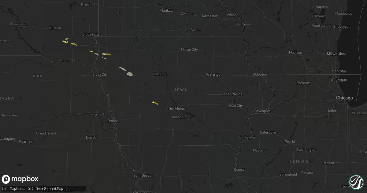
Get this storm
October 8 map
$229
one time, instant access
Download today. No call, no setup
Keep the $229
Bought the map and want the full workflow? Apply the entire $229 to a subscription within 7 days. None of it is wasted.
Every map, not just this one
This buys you this map. Subscription and you get every map we run, in the markets you choose from a few cities to whole states to nationwide. Plus real-time alerts the moment a storm fires.
Contact data
Name, contact info, occupancy, even credit band for addresses in the footprint. You go from where it hit to who to call.
Become the source they trust
Unlimited branding weather history reports on demand. You already have the documented answer ready for the property owner, and you are the one who showed up with it.
Property data and RoofTrace estimates
Pull up any address you have got, its value and the exact code rules for that jurisdiction, straight from One Click Code. Then RoofTrace estimates the squares, pitch, and roof value, priced the way you price.
Storm reports in Iowa
Iowa
| Date | Description |
|---|---|
| 10/08/20262:45 AM CDT | A local report indicates 1.00 inch wind near 6 N Cleghorn |
| 10/08/20262:01 AM CDT | Report from social media. Time estimated from radar. |
| 10/08/20261:45 AM CDT | A local report indicates 1.25 inch wind near 5 N Remsen |
| 10/08/20261:03 AM CDT | Ground was white with various size hail up to quarter size. |
| 10/08/202612:54 AM CDT | Social media report and photo of hail just smaller than a golf ball near lake city. Time and location estimated with radar. Delayed report. |
| 10/08/202612:52 AM CDT | Trained spotted called with a measured 1 inch hail report on the 200 block of lloyd st. In lake city. |
| 10/08/202612:48 AM CDT | Report from social media. |
| 10/08/202612:47 AM CDT | Report from social media... Size estimated from picture. |
| 10/08/202612:40 AM CDT | Social media picture and report of half dollar sized hail in the jackson township in southwest calhoun county. Time and location estimated with radar. Delayed report. |
| 10/08/202612:34 AM CDT | Report from social media. |
| 10/08/202612:16 AM CDT | Social media report of quarter sized hail after midnight near carnarvon. Location and time estimated with radar. Delayed report. |
| 10/07/202611:55 PM CDT | Extended period of hail... Briefly as large as quarters. |
| 10/07/202611:15 PM CDT | Social media report of hail up to quarter sized hail just west of jefferson. Time estimated with radar. Delayed report. |
| 10/07/202611:01 PM CDT | A local report indicates 1.25 inch wind near W Norwalk |
| 10/07/202611:01 PM CDT | Social media report and picture of quarter sized hail north of indianola. Time and location radar estimated. Delayed report. |
| 10/07/202610:47 PM CDT | Picture of hail between cumming and norwalk. Time and location estimated from radar. Relayed via social media. |
| 10/07/202610:46 PM CDT | A local report indicates 1.00 inch wind near 2 NNW Brunsville |
| 10/07/202610:45 PM CDT | Picture of golf ball sized hail south of cumming. Relayed via broadcast media. Time and location estimated with radar. Delayed report. |
| 10/07/202610:45 PM CDT | Pea up to ping pong ball sized hail. Delayed report from social media. |
| 10/07/202610:37 PM CDT | Photos posted to social media. Time estimated based on radar. |
| 10/07/202610:24 PM CDT | Social media report of hail up to golf ball size south and southwest of wall lake. Time and location estimated with radar. Delayed report. |
| 10/07/202610:20 PM CDT | Social media report with picture of hail at least one inch in diameter in de soto. Delayed report. |
| 10/07/202610:20 PM CDT | Broadcast media relayed report from wall lake ia of half dollar size hail. Time estimated from radar. |
| 10/07/202610:13 PM CDT | A local report indicates 1.75 inch wind near 2 S Maurice |
| 10/07/202610:10 PM CDT | Social media report of gold ball sized hail east of redfield. Time and location estimated with radar. Delayed report. |
| 10/07/202610:05 PM CDT | A local report indicates 1.50 inch wind near Ireton |
| 10/07/202610:05 PM CDT | Photos posted to social media. Time estimated based on radar. |
| 10/07/202610:05 PM CDT | Public report of quarter sized hail out of redfield area. Time estimated from radar. |
| 10/07/202610:05 PM CDT | Broadcast media relayed report of quarter-size hail out of redfield. |
| 10/07/20269:50 PM CDT | A local report indicates 1.50 inch wind near 5 SW Granville |
| 10/07/20269:37 PM CDT | Photo posted to social media. Time estimated based on radar. |
| 10/07/20269:37 PM CDT | Broadcast media relayed report of 1.5" diameter hail out of panora. |
| 10/07/20269:33 PM CDT | Social media picture and report of half dollar sized hail near lake panorama. Time and location estimated with radar. Delayed report. |
| 10/07/20269:26 PM CDT | Report from mping: quarter |
All States Impacted by Hail Map on October 8, 2026
Cities Impacted by Hail Map on October 8, 2026
- Morristown, TN
- Russellville, TN
- Bybee, TN
- Mohawk, TN
- Whitesburg, TN
- Knoxville, TN
- Seymour, TN
- Gatlinburg, TN
- Strawberry Plains, TN
- Mascot, TN
- Kodak, TN
- Luttrell, TN
- Jefferson City, TN
- New Market, TN
- Newport, TN
- Talbott, TN
- Corryton, TN
- Freeman, SD
- Olivet, SD
- Marion, SD
- Hurley, SD
- Alcester, SD
- Beresford, SD
- Menno, SD
- Hawarden, IA
- Ireton, IA
- Cherokee, IA
- Cleghorn, IA
- Quimby, IA
- Aurelia, IA
- Galva, IA
- Schaller, IA
- Sioux Center, IA
- Orange City, IA
- Alton, IA
- Panora, IA
- Guthrie Center, IA
- Maurice, IA
- Hinton, IA
- Early, IA
- Le Mars, IA
- Yale, IA
- Remsen, IA
- Ida Grove, IA
- Odebolt, IA
- Holstein, IA
- Granville, IA
- Arthur, IA
- Rippey, IA
- Centerville, SD
- Wakonda, SD
- Lake View, IA
- Wall Lake, IA
- Redfield, IA
- Linden, IA
- Marcus, IA
- Adel, IA
- Coon Rapids, IA
- Irene, SD
- Earlham, IA
- Stuart, IA
- Moville, IA
- Bagley, IA
- Jamaica, IA
- Dawson, IA
- Perry, IA
- De Soto, IA
- Van Meter, IA
- Meriden, IA
- Waukee, IA
- Breda, IA
- Akron, IA
- Chatsworth, IA
- Carroll, IA
- Auburn, IA
- Rockwell City, IA
- Vail, IA
- Woodward, IA
- Booneville, IA
- Cumming, IA
- West Des Moines, IA
- Elk Point, SD
- Sac City, IA
- Glidden, IA
- Norwalk, IA
- Indianola, IA
- Prole, IA
- Des Moines, IA
- Arcadia, IA
- Scranton, IA
- Winterset, IA
- Brunsville, IA
- Battle Creek, IA
- Carlisle, IA
- Saint Charles, IA
- Jefferson, IA
- Storm Lake, IA
- Alta, IA
- Larrabee, IA
- Lidderdale, IA
- Cushing, IA
- Correctionville, IA
- Churdan, IA
- New Virginia, IA
- Pleasantville, IA
- Paullina, IA
- Ackworth, IA
- Milo, IA
- Lacona, IA
- Grand Junction, IA
- Liberty Center, IA
- Kiron, IA
- Melcher Dallas, IA
- Knoxville, IA
- Lytton, IA
- Jolley, IA
- Sutherland, IA
- Urbandale, IA
- Hudson, SD
- Rock Valley, IA
- Russell, IA
- Chariton, IA
- Hamilton, IA
- Bussey, IA
- Bouton, IA
- Melrose, IA
- Granger, IA
- Grimes, IA
- Somers, IA
- Lovilia, IA
- Lohrville, IA
- Farnhamville, IA
- Hull, IA
- Gowrie, IA
- Albia, IA
- Lake City, IA
- Newell, IA
- Unionville, IA
- Albert City, IA
- Drakesville, IA
- Canton, SD
- Fonda, IA
- Fairview, SD
- Bloomfield, IA
- Pilot Mound, IA
- Ogden, IA
- Paton, IA
- Boxholm, IA
- Boone, IA
- Madrid, IA
- Kelley, IA
- Ames, IA
- Luther, IA
- Slater, IA
- Alleman, IA
- Ankeny, IA
- Elkhart, IA
- Bondurant, IA
- Maxwell, IA
- Mitchellville, IA
- Story City, IA
- Mingo, IA
- Colfax, IA
- Prairie City, IA
- Oskaloosa, IA
- Beacon, IA
- New Sharon, IA
- Rose Hill, IA
- Viborg, SD
- Johnston, IA
- Lanesboro, IA
- Windsor Heights, IA


