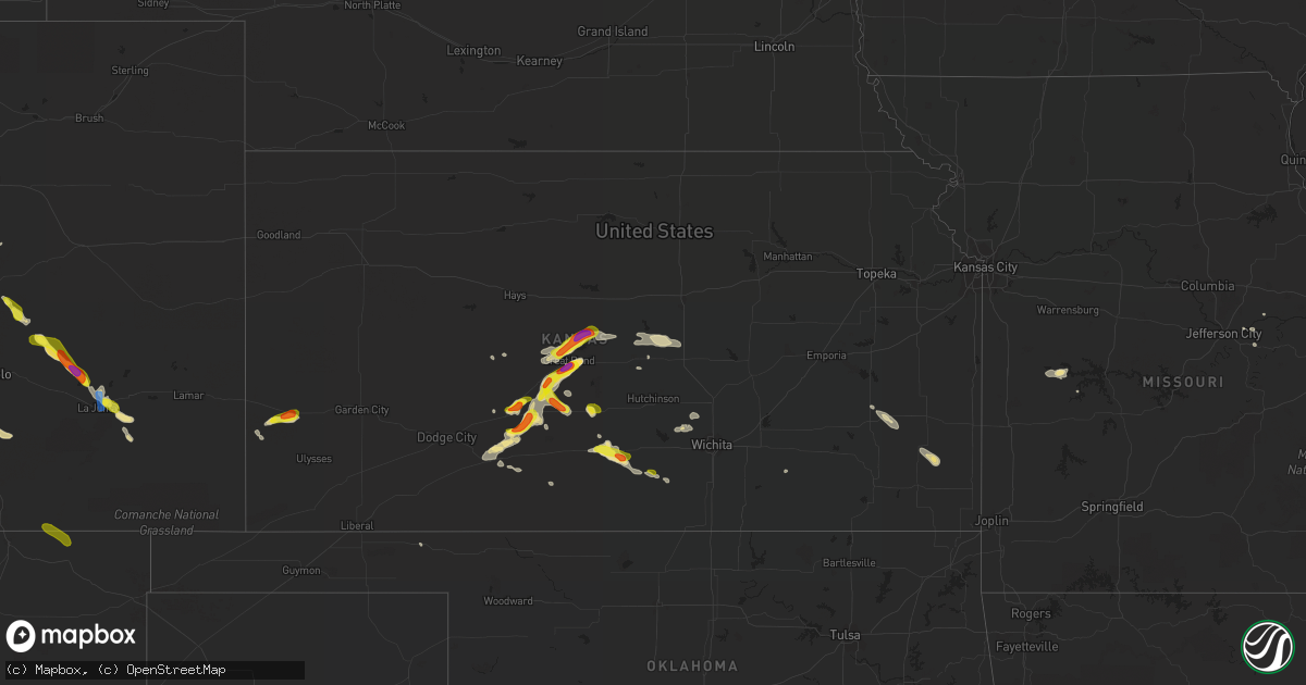
Hail Map in Kansas on September 14, 2021
Get this storm
September 14 map
$229
one time, instant access
Download today. No call, no setup
Keep the $229
Bought the map and want the full workflow? Apply the entire $229 to a subscription within 7 days. None of it is wasted.
Every map, not just this one
This buys you this map. Subscription and you get every map we run, in the markets you choose from a few cities to whole states to nationwide. Plus real-time alerts the moment a storm fires.
Contact data
Name, contact info, occupancy, even credit band for addresses in the footprint. You go from where it hit to who to call.
Become the source they trust
Unlimited branding weather history reports on demand. You already have the documented answer ready for the property owner, and you are the one who showed up with it.
Property data and RoofTrace estimates
Pull up any address you have got, its value and the exact code rules for that jurisdiction, straight from One Click Code. Then RoofTrace estimates the squares, pitch, and roof value, priced the way you price.
Storm reports in Kansas
Kansas
| Date | Description |
|---|---|
| 09/14/20216:30 PM CDT | Report received from social media. |
| 09/14/20216:15 PM CDT | Report from social media with picture. |
| 09/14/20216:15 PM CDT | Report received from social media. |
| 09/14/20216:06 PM CDT | A local report indicates 1.00 inch wind near 1 NE CENTERVIEW |
| 09/14/20216:06 PM CDT | A local report indicates 1.00 inch wind near CENTERVIEW |
| 09/14/20215:15 PM CDT | Delayed report from social media... Large amount of branches down. |
| 09/14/20216:18 AM CDT | At 1117 PM CDT, a severe thunderstorm was located near Dillwyn, moving south at 15 mph. HAZARD...60 mph wind gusts and half dollar size hail. SOURCE...Radar indicated. IMPACT...Hail damage to vehicles is expected. Expect wind damage to roofs, siding, and trees. This severe thunderstorm will be near... Macksville and Dillwyn around 1135 PM CDT. |
| 09/14/20215:11 AM CDT | At 1011 PM CDT/911 PM MDT/, a severe thunderstorm was located near Kendall, moving east at 30 mph. HAZARD...Quarter size hail. SOURCE...Radar indicated. IMPACT...Damage to vehicles is expected. This severe thunderstorm will be near... Kendall around 920 PM MDT. |
| 09/14/20213:58 AM CDT | At 857 PM CDT, a severe thunderstorm was located 6 miles northeast of Hoisington, moving northeast at 20 mph. HAZARD...Golf ball size hail and 60 mph wind gusts. SOURCE...Radar indicated. IMPACT...People and animals outdoors will be injured. Expect hail damage to roofs, siding, windows, and vehicles. Expect wind damage to roofs, siding, and trees. Locations impacted include... Ellsworth, Hoisington, Wilson, Claflin, Holyrood, Dorrance, Ellsworth Airport and Odin.This includes Interstate 70 between Mile Markers 201 and 217. |
| 09/14/20213:20 AM CDT | At 820 PM CDT, severe thunderstorms were located along a line extending from 6 miles northwest of Great Bend to 5 miles west of Ellinwood, moving east at 25 mph. HAZARD...60 mph wind gusts and half dollar size hail. SOURCE...Radar indicated. IMPACT...Hail damage to vehicles is expected. Expect wind damage to roofs, siding, and trees. Locations impacted include... Great Bend, Hoisington, Ellinwood, Claflin, Holyrood, Bushton, Albert, Lorraine, Olmitz, Galatia, Susank, Great Bend Airport, Cheyenne Bottoms, Silica and Odin. |
| 09/14/20211:44 AM CDT | At 644 PM CDT, a severe thunderstorm was located near Garfield, moving northeast at 20 mph. HAZARD...60 mph wind gusts and half dollar size hail. SOURCE...Radar indicated. IMPACT...Hail damage to vehicles is expected. Expect wind damage to roofs, siding, and trees. This severe thunderstorm will be near... Garfield around 650 PM CDT.Other locations in the path of this severe thunderstorm include Zook,Frizell and Larned. |
| 09/14/20211:42 AM CDT | At 641 PM CDT, a severe thunderstorm was located near Stafford, and is nearly stationary. HAZARD...Half dollar size hail. SOURCE...Radar indicated. IMPACT...Damage to vehicles is expected. Locations impacted include... Zenith. |
| 09/14/20211:20 AM CDT | At 620 PM CDT, a severe thunderstorm was located very near Kinsley, moving east at 10 mph. HAZARD...Half dollar size hail. SOURCE...Radar indicated. IMPACT...Damage to vehicles is expected. Locations impacted include... Lewis. |
| 09/14/202112:52 AM CDT | At 552 PM CDT, a severe thunderstorm was located very near Centerview, moving northeast at 20 mph. HAZARD...Golf ball size hail and 60 mph wind gusts. SOURCE...Radar indicated. IMPACT...People and animals outdoors will be injured. Expect hail damage to roofs, siding, windows, and vehicles. Expect wind damage to roofs, siding, and trees. This severe thunderstorm will be near... Fellsburg around 605 PM CDT.Other locations in the path of this severe thunderstorm includeLewis, Belpre, Macksville and Zook. |
| 09/14/202112:30 AM CDT | At 530 PM CDT, a severe thunderstorm was located 6 miles southeast of Cunningham, or 12 miles west of Kingman, moving east at 20 mph. HAZARD...60 mph wind gusts and half dollar size hail. SOURCE...Radar indicated. IMPACT...Hail damage to vehicles is expected. Expect wind damage to roofs, siding, and trees. Locations impacted include... Kingman, Willowdale, Cleveland, Penalosa and Kingman Airport. |
| 09/14/202112:09 AM CDT | At 508 PM CDT, a severe thunderstorm was located over Cunningham, or 6 miles east of Cairo, moving east at 15 mph. HAZARD...60 mph wind gusts and half dollar size hail. SOURCE...Radar indicated. IMPACT...Hail damage to vehicles is expected. Expect wind damage to roofs, siding, and trees. Locations impacted include... Kingman, Cunningham, Willowdale, Cleveland, Penalosa and Kingman Airport. |
| 09/13/202111:30 PM CDT | Damage to door and roof on hay shed. 3 to 4 inch tree limbs blown down. |
| 09/13/202110:15 PM CDT | Hailed for 5-10 minutes and covered the ground. Most hail was small. |
| 09/13/20218:40 PM CDT | Also reported high winds... But did not specify speed estimate. |
| 09/13/20218:16 PM CDT | Quarter to half dollar size. |
| 09/13/20218:10 PM CDT | Delayed report. Received via social media from ksn tv. |
All States Impacted by Hail Map on September 14, 2021
Cities Impacted by Hail Map on September 14, 2021
- Lyons, OH
- Wauseon, OH
- Fowlerville, MI
- Converse, IN
- Marion, IN
- La Fontaine, IN
- Hoisington, KS
- Claflin, KS
- Great Bend, KS
- Walsenburg, CO
- Colorado Springs, CO
- Upton, WY
- Sturgis, MI
- White Pigeon, MI
- Constantine, MI
- Danville, IN
- Pendleton, IN
- Sandusky, MI
- Deckerville, MI
- Carsonville, MI
- Port Sanilac, MI
- Medina, OH
- Fenton, MI
- Howell, MI
- Cass City, MI
- Ubly, MI
- Muncie, IN
- Gaston, IN
- Yorktown, IN
- Alexandria, IN
- Marlette, MI
- Brown City, MI
- Peru, IN
- Herrick, IL
- Lakewood, IL
- Beecher City, IL
- Tower Hill, IL
- Cowden, IL
- Macksville, KS
- Haviland, KS
- Lewis, KS
- Hartland, MI
- Brighton, MI
- Highland, MI
- Hudson, MI
- Pittsford, MI
- Osseo, MI
- Gate, OK
- Middletown, IN
- La Junta, CO
- Elmore, OH
- Graytown, OH
- North Adams, MI
- Calhan, CO
- Yoder, CO
- Kinsley, KS
- Belpre, KS
- Las Animas, CO
- Denver, IN
- Terre Haute, IN
- Pawnee Rock, KS
- Larned, KS
- Shipshewana, IN
- Holyrood, KS
- Bushton, KS
- Lorraine, KS
- Cunningham, KS
- Kingman, KS
- Ordway, CO
- New Paris, IN
- Goshen, IN
- Daleville, IN
- Wabash, IN
- Coldwater, MI
- Quincy, MI
- Reading, MI
- Peyton, CO
- Marquette, KS
- Stafford, KS
- Walnut, KS
- Erie, KS
- Saint Paul, KS
- Niles, MI
- Edwardsburg, MI
- Vandalia, MI
- Cassopolis, MI
- Eagle, MI
- Harbor Springs, MI
- Louisville, IL
- Clay City, IL
- Sugar City, CO
- Mooreland, IN
- Springport, IN
- New Castle, IN
- Little River, KS
- Lindsborg, KS
- Windom, KS
- Dieterich, IL
- Wheeler, IL
- Newton, IL
- Hillsboro, IL
- Coffeen, IL
- Donnellson, IL
- Washington, MO
- Milton, KS
- Argonia, KS
- Norwich, KS
- Kingman, IN
- Bainbridge, IN
- Greencastle, IN
- Fillmore, IN
- Coatesville, IN
- Ceresco, MI
- Battle Creek, MI
- Marshall, MI
- Greensburg, KS
- Elbert, CO
- Franktown, CO
- Elizabeth, CO
- Losantville, IN
- Sterling, KS
- Lyons, KS
- Kewanna, IN
- Burnettsville, IN
- Lucerne, IN
- Royal Center, IN
- Albert, KS
- Moorcroft, WY
- Greenville, IL
- Garfield, KS
- Williamston, MI
- Okemos, MI
- Mason, MI
- Hagerstown, IN
- Kendall, KS
- St John, KS
- Kokomo, IN
- Collinsville, IL
- Hartford, IL
- Granite City, IL
- Maryville, IL
- Edwardsville, IL
- Glen Carbon, IL
- Amboy, IN
- Van Buren, IN
- Swayzee, IN
- Saint Ignace, MI
- Mackinac Island, MI
- Bellevue, MI
- Deepwater, MO
- Clinton, MO
- Syracuse, KS
- Millington, MI
- Vassar, MI
- Frankfort, IN
- Mount Hope, KS
- Colwich, KS
- Andale, KS
- Bad Axe, MI
- Sandoval, IL
- Carlyle, IL
- Centralia, IL
- Mcpherson, KS
- Ellsworth, KS
- Mason, IL
- Edgewood, IL
- Farina, IL
- Lerna, IL
- Trilla, IL
- Iola, KS
- Yates Center, KS
- Humboldt, KS
- Piqua, KS
- Onaway, MI
- Cambridge City, IN
- Jones, MI
- Granger, IN
- South Bend, IN
- Kinmundy, IL
- Alma, IL
- Sun City, KS
- Howe, IN
- Charlotte, MI
- Olivet, MI
- Eaton Rapids, MI
- Springport, MI
- West Liberty, IL
- Greentown, IN
- Sweetser, IN
- Vermontville, MI
- Anderson, IN
- Union City, MI
- Athens, MI
- New Haven, MO
- Logansport, IN
- Walton, IN
- Lafayette, IN
- Westpoint, IN
- Jewett, IL
- Effingham, IL
- Montrose, IL
- Markleville, IN
- Summitville, IN
- Amo, IN
- Sedgwick, KS
- Webberville, MI
- Dansville, MI
- Palms, MI
- Ruth, MI
- Detroit, MI
- Dearborn, MI
- Birch Run, MI
- Montrose, MI
- Chesaning, MI
- Burt, MI
- Sylvania, OH
- Berkey, OH
- Holland, OH
- Swanton, OH
- Metamora, OH
- Knightstown, IN
- Clayton, IN
- Middlebury, IN
- Boone, CO
- Idaville, IN
- Delphi, IN
- Twelve Mile, IN
- Cheraw, CO
- Kiowa, CO
- Saint Louis, MO
- Andrews, IN
- Huntington, IN
- Lagro, IN
- Caro, MI
- Decker, MI
- Deford, MI
- Belleville, IL
- Clarks Hill, IN
- Ingraham, IL
- Sailor Springs, IL
- Olney Springs, CO
- Rogers City, MI
- Manitou Beach, MI
- Addison, MI
- Fairmount, IN
- Xenia, IL
- Whitestown, IN
- Lebanon, IN
- Hillsdale, MI
- Burr Oak, MI
- Hume, IL
- Litchfield, MI
- Perrysville, IN
- Bunker Hill, IN
- Miami, IN
- Grissom Arb, IN
- Macy, IN
- Roann, IN
- Warren, IN
- Galveston, IN
- Newman, IL
- Offerle, KS
- Fostoria, MI
- Three Rivers, MI
- Jonesville, MI
- Allen, MI
- Spivey, KS
- Mayville, MI
- Clayton, MI
- Warrenton, MO
- Goodrich, MI
- Rocky Ford, CO
- East Leroy, MI
- Martinsville, IN
- Morgantown, IN
- Perry, MI
- Dearborn Heights, MI
- Garden City, MI
- Westland, MI
- Inkster, MI
- Perrysburg, OH
- Genoa, OH
- Woodville, OH
- Mullinville, KS
- Bucklin, KS
- Holly, MI
- Linden, MI
- Cloverdale, IN
- Putnamville, IN
- Jasper, MI
- Thorntown, IN
- Patoka, IL
- Odin, IL
- Hoffman, IL
- Central Lake, MI
- East Jordan, MI
- Boyne City, MI
- Monrovia, IN
- Mooresville, IN
- Monument, CO
- Jackson, MI
- Millstadt, IL
- Smithton, IL
- Freeburg, IL
- Mascoutah, IL
- Ellinwood, KS
- Notre Dame, IN
- Mishawaka, IN
- West Unity, OH
- Fayette, OH
- Archbold, OH
- Jonesboro, IN
- Dunbridge, OH
- Bowling Green, OH
- Geneseo, KS
- Pratt, KS
- Rochester, IN
- Bonnots Mill, MO
- Chamois, MO
- Applegate, MI
- Peck, MI
- Bridgeport, MI
- Frankenmuth, MI
- Linn, MO
- Flora, IN
- Camden, IN
- Wyandotte, MI
- Ecorse, MI
- Lincoln Park, MI
- Southgate, MI
- Colfax, IN
- Albers, IL
- New Baden, IL
- Indianapolis, IN
- Greenwood, IN
- Nekoma, KS
- Rush Center, KS
- Clifford, MI
- North Branch, MI
- Turon, KS
- Levering, MI
- Romulus, MI
- Flat Rock, MI
- Brownsburg, IN
- Pittsboro, IN
- Gays, IL
- Windsor, IL
- Toledo, OH
- Maumee, OH
- Monclova, OH
- Fremont, OH
- Oak Harbor, OH
- Port Clinton, OH
- Metcalf, IL
- Chrisman, IL
- Steedman, MO
- Portland, MO
- Bentley, KS
- Halstead, KS
- Tebbetts, MO
- Alexander, KS
- Silverwood, MI
- Pellston, MI
- Fulton, MI
- Vicksburg, MI
- Leonidas, MI
- Mendon, MI
- Sherwood, MI
- Colon, MI
- Harbor Beach, MI
- Millersburg, IN
- Lagrange, IN
- Topeka, IN
- Bristol, IN
- Leslie, MO
- Latham, KS
- Montrose, MO
- Wolverine, MI
- Osceola, MO
- Whiteland, IN
- Minden City, MI
- Royal Oak, MI
- Madison Heights, MI
- Troy, MI
- Sterling Heights, MI
- Oak Park, MI
- Berkley, MI
- Clawson, MI
- Southfield, MI
- Indian River, MI
- Cheboygan, MI
- Afton, MI
- Millersburg, MI
- Trinchera, CO
- Folsom, NM
- Raton, NM
- Haskins, OH
- Clay Center, OH
- Northwood, OH
- Rocky Ridge, OH
- Oregon, OH
- McClure, OH
- Waterville, OH
- Walbridge, OH
- Stony Ridge, OH
- Weston, OH
- Luckey, OH
- Rossford, OH
- Tontogany, OH
- Curtice, OH
- Pemberville, OH
- Martin, OH
- Millbury, OH
- Grand Rapids, OH
- Sylvia, KS
- Lakin, KS


