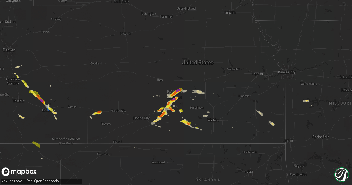
Hail Map on September 14, 2021
Get this storm
September 14 map
$229
one time, instant access
Download today. No call, no setup
Keep the $229
Bought the map and want the full workflow? Apply the entire $229 to a subscription within 7 days. None of it is wasted.
Every map, not just this one
This buys you this map. Subscription and you get every map we run, in the markets you choose from a few cities to whole states to nationwide. Plus real-time alerts the moment a storm fires.
Contact data
Name, contact info, occupancy, even credit band for addresses in the footprint. You go from where it hit to who to call.
Become the source they trust
Unlimited branding weather history reports on demand. You already have the documented answer ready for the property owner, and you are the one who showed up with it.
Property data and RoofTrace estimates
Pull up any address you have got, its value and the exact code rules for that jurisdiction, straight from One Click Code. Then RoofTrace estimates the squares, pitch, and roof value, priced the way you price.
States Impacted by Hail Map on September 14, 2021
Storm reports
Illinois
| Date | Description |
|---|---|
| 09/14/20216:50 PM CDT | A local report indicates 63 MPH wind near 2 SSE MASCOUTAH |
| 09/14/20215:35 PM CDT | Power lines down. Wind damage also noted to corn crops. |
| 09/14/20212:31 AM CDT | At 731 PM CDT, severe thunderstorms were located along a line extending from near Newton to near Kinmundy, moving east at 35 mph. HAZARD...60 mph wind gusts and quarter size hail. SOURCE...Radar indicated. IMPACT...Hail damage to vehicles is expected. Expect wind damage to roofs, siding, and trees. Severe thunderstorms will be near... Newton and Wheeler around 735 PM CDT. Willow Hill around 745 PM CDT.Other locations in the path of these severe thunderstorms includeIola, Louisville, Bible Grove, Sailor Springs and Ingraham. |
| 09/14/20211:45 AM CDT | At 645 PM CDT, a severe thunderstorm was located over Freeburg, moving east at 25 mph. HAZARD...60 mph wind gusts. SOURCE...Radar indicated. IMPACT...Expect damage to roofs, siding, and trees. This severe thunderstorm will be near... New Athens around 650 PM CDT.Other locations impacted by this severe thunderstorm includeLenzburg, St. Libory and Fayetteville. |
Indiana
| Date | Description |
|---|---|
| 09/14/20216:35 PM CDT | Several 6-8” live limbs broken & a few 8-12” live trees down. Also about 1/2 mile of corn blown down along the road. |
| 09/14/20216:35 PM CDT | Several 6-8 inch live limbs broken & a few 8-12 inch live trees down. Also about 1/2 mile of corn blown down along the road. |
| 09/14/20215:48 PM CDT | Trees and powerlines down. Time estimated by radar. |
| 09/14/20215:47 AM CDT | At 1047 PM EDT, a severe thunderstorm was located 9 miles northwest of New Castle, or 11 miles southeast of Anderson, moving east at 20 mph. HAZARD...60 mph wind gusts and quarter size hail. SOURCE...Radar indicated. IMPACT...Hail damage to vehicles is expected. Expect wind damage to roofs, siding, and trees. This severe thunderstorm will be near... Cadiz around 1050 PM EDT. Sulphur Springs around 1055 PM EDT. Springport around 1100 PM EDT. Mount Summit around 1105 PM EDT.Other locations in the path of this severe thunderstorm include NewCastle, Mooreland, Blountsville and Summit Lake State Park.This includes Interstate 70 near mile marker 133. |
| 09/14/20215:28 AM CDT | At 1027 PM EDT, a severe thunderstorm was located near Muncie, moving east at 25 mph. HAZARD...60 mph wind gusts and quarter size hail. SOURCE...Radar indicated. IMPACT...Hail damage to vehicles is expected. Expect wind damage to roofs, siding, and trees. This severe thunderstorm will be near... Prairie Creek Reservoir around 1045 PM EDT.Other locations in the path of this severe thunderstorm includeSelma. |
| 09/14/20213:46 AM CDT | At 846 PM EDT, a severe thunderstorm was located over Marion, moving east at 30 mph. HAZARD...60 mph wind gusts and penny size hail. SOURCE...Law enforcement. IMPACT...Expect damage to roofs, siding, and trees. Locations impacted include... Marion, Hartford City, Gas City, Upland, Montpelier, Jonesboro, Sweetser, Swayzee, Van Buren, Sims, Converse, Poneto, Mcnatts, Landess, Mount Zion, Mier, Herbst, Keystone, Roseburg and Home Corner.This includes Interstate 69 in Indiana between mile markers 257 and271. |
| 09/14/20211:31 AM CDT | At 631 PM EDT, a severe thunderstorm was located 10 miles southwest of Rochester, moving northeast at 40 mph. HAZARD...60 mph wind gusts and penny size hail. SOURCE...Radar indicated. IMPACT...Expect damage to roofs, siding, and trees. Locations impacted include... Rochester, Akron, Fulton, Macy, Nyena Lake, Leases Corner, Deedsville, Athens, Twelve Mile, Metea, Grass Creek, Fletcher, Lake Manitou, Gilead, Lucerne and Marshtown. |
| 09/13/202111:28 PM CDT | At 427 PM EDT, a severe thunderstorm was located over Edwardsburg, moving northeast at 45 mph. HAZARD...60 mph wind gusts and quarter size hail. SOURCE...Radar indicated. IMPACT...Hail damage to vehicles is expected. Expect wind damage to roofs, siding, and trees. Locations impacted include... Constantine, White Pigeon, Three Rivers, Centreville and Colon. |
| 09/13/20219:29 PM CDT | Tree limbs one inch in diameter broken. Shingles blown off. |
| 09/13/20219:25 PM CDT | Late report of power lines down. Time estimated by radar. |
| 09/13/20219:23 PM CDT | Tree down at county road 100 north and county road 500 west. |
| 09/13/20217:41 PM CDT | Tree across road. |
| 09/13/20217:05 PM CDT | Multiple trees and tree limbs blown down in south-central huntington county. Time estimated by radar. |
Texas
| Date | Description |
|---|---|
| 09/14/20215:17 AM CDT | At 1017 PM CDT, a severe thunderstorm was located 6 miles east of Nara Visa, moving east at 20 mph. HAZARD...60 mph wind gusts and quarter size hail. SOURCE...Radar indicated. IMPACT...Minor damage to roofs, siding, and trees is possible. Hail damage to vehicles is expected. This severe thunderstorm will remain over mainly rural areas of northwestern Oldham and southwestern Hartley Counties. |
Missouri
| Date | Description |
|---|---|
| 09/14/20216:09 PM CDT | *** 1 fatal... 1 inj *** a dead tree fell on a vehicle injuring the driver and killing the passenger. A witness in a trailing vehicle reported there was only light wind |
| 09/14/20215:11 PM CDT | Several 2 to 3 inch diameter tree limbs and one around 5 inch diameter tree limb downed. |
| 09/14/20215:07 PM CDT | Numerous around 3 inch diameter tree limbs downed. |
Vermont
| Date | Description |
|---|---|
| 09/13/202110:59 PM CDT | Law enforcement reports tree down near the intersection of main st and south rd in peru. Time estimated from radar |
New York
| Date | Description |
|---|---|
| 09/14/20212:33 AM CDT | Tree on wires on delancy ave. Time estimated by radar. |
Wyoming
| Date | Description |
|---|---|
| 09/14/20215:34 PM CDT | A local report indicates 1.75 inch wind near 3 WNW MOORCROFT |
| 09/13/202111:33 PM CDT | At 432 PM MDT, a severe thunderstorm was located 3 miles west of Moorcroft, or 22 miles east of Gillette, moving east at 20 mph. HAZARD...Ping pong ball size hail. SOURCE...Radar indicated. IMPACT...People and animals outdoors will be injured. Expect damage to roofs, siding, windows, and vehicles. This severe thunderstorm will be near... Moorcroft around 445 PM MDT.Other locations in the path of this severe thunderstorm includeUpton.This includes Interstate 90 in Wyoming between Mile Markers 148 and171. |
Colorado
| Date | Description |
|---|---|
| 09/14/20216:45 PM CDT | 2-3 inch limbs of trees snapped off of healthy trees - green growth was noted on the limbs. Metal siding and roofing debris reported scattered around ordway. |
| 09/14/20214:50 PM CDT | Winds of 50 mph or greater was also observed. |
| 09/14/20213:45 PM CDT | Hail was mixed with pea to quarter size... Possibly larger. |
| 09/14/20211:20 AM CDT | At 618 PM MDT, severe thunderstorms were located along a line extending from near North La Junta to near Blue Lake, moving east at 30 mph. HAZARD...70 mph wind gusts and quarter size hail. SOURCE...La Junta automated weather sensor measured 70 mph winds. IMPACT...Hail damage to vehicles is expected. Expect considerable tree damage. Wind damage is also likely to mobile homes, roofs, and outbuildings. Severe thunderstorms will be near... Blue Lake around 625 PM MDT.Other locations in the path of these severe thunderstorms includeHasty. |
| 09/14/20211:13 AM CDT | At 612 PM MDT, a severe thunderstorm was located near Trinchera, or 19 miles northwest of Des Moines, moving southeast at 20 mph. HAZARD...60 mph wind gusts and quarter size hail. SOURCE...Radar indicated. IMPACT...Hail damage to vehicles is expected. Expect wind damage to roofs, siding, and trees. Locations impacted include... Des Moines, Folsom and Capulin. This includes Highway 64 between Mile Markers 376 and 389. |
| 09/14/20211:09 AM CDT | At 609 PM MDT, a severe thunderstorm was located near Trinchera, or 21 miles northwest of Des Moines, moving east at 20 mph. HAZARD...60 mph wind gusts and quarter size hail. SOURCE...Radar indicated. IMPACT...Hail damage to vehicles is expected. Expect wind damage to roofs, siding, and trees. Locations impacted include... Branson. |
| 09/14/202112:45 AM CDT | At 544 PM MDT, a severe thunderstorm was located over Sugar City, or 18 miles northwest of La Junta, moving southeast at 20 mph. HAZARD...Two inch hail and 60 mph wind gusts. SOURCE...Radar indicated. IMPACT...People and animals outdoors will be injured. Expect hail damage to roofs, siding, windows, and vehicles. Expect wind damage to roofs, siding, and trees. Locations impacted include... Rocky Ford, Cheraw, Swink, La Junta and North La Junta. |
| 09/13/202111:58 PM CDT | At 457 PM MDT, a severe thunderstorm was located 14 miles northwest of Crowley, or 35 miles northwest of La Junta, moving southeast at 30 mph. HAZARD...Golf ball size hail and 60 mph wind gusts. SOURCE...Radar indicated. IMPACT...People and animals outdoors will be injured. Expect hail damage to roofs, siding, windows, and vehicles. Expect wind damage to roofs, siding, and trees. Locations impacted include... Crowley, Ordway and Sugar City. |
| 09/13/202111:46 PM CDT | At 446 PM MDT, a severe thunderstorm was located 7 miles north of Trinidad, moving southeast at 45 mph. HAZARD...60 mph wind gusts and quarter size hail. SOURCE...Radar indicated. IMPACT...Hail damage to vehicles is expected. Expect wind damage to roofs, siding, and trees. This severe thunderstorm will be near... Trinidad, Starkville and Hoehne around 455 PM MDT.Other locations in the path of this severe thunderstorm includeTrinchera. |
| 09/13/202111:17 PM CDT | At 416 PM MDT, a severe thunderstorm was located 7 miles northeast of Hanover, or 28 miles east of Colorado Springs, moving southeast at 25 mph. HAZARD...60 mph wind gusts and half dollar size hail. SOURCE...Radar indicated. IMPACT...Hail damage to vehicles is expected. Expect wind damage to roofs, siding, and trees. This severe thunderstorm will be near... Truckton around 425 PM MDT. |
| 09/13/202110:32 PM CDT | At 332 PM MDT, a severe thunderstorm was located near Schriever AFB, or 18 miles east of Colorado Springs, moving southeast at 30 mph. HAZARD...60 mph wind gusts and quarter size hail. SOURCE...Radar indicated. IMPACT...Hail damage to vehicles is expected. Expect wind damage to roofs, siding, and trees. This severe thunderstorm will be near... Ellicott around 345 PM MDT.Other locations in the path of this severe thunderstorm include Yoderand Truckton. |
| 09/13/20219:59 PM CDT | At 258 PM MDT, a severe thunderstorm was located over Black Forest, or 13 miles northeast of Colorado Springs, moving southeast at 15 mph. HAZARD...60 mph wind gusts and quarter size hail. SOURCE...Radar indicated. IMPACT...Hail damage to vehicles is expected. Expect wind damage to roofs, siding, and trees. This severe thunderstorm will be near... Falcon around 315 PM MDT. |
| 09/13/20219:33 PM CDT | At 233 PM MDT, a severe thunderstorm was located near Black Forest, or 15 miles north of Colorado Springs, moving southeast at 20 mph. HAZARD...Quarter size hail. SOURCE...Radar indicated. IMPACT...Damage to vehicles is expected. This severe thunderstorm will be near... Black Forest around 245 PM MDT. |
| 09/13/20219:08 PM CDT | At 207 PM MDT, a severe thunderstorm was located 4 miles northwest of Elbert, or 28 miles north of Colorado Springs, moving east at 20 mph. HAZARD...60 mph wind gusts and quarter size hail. SOURCE...Radar indicated. IMPACT...Expect damage to roofs, siding, and trees. Hail damage to vehicles is expected. This severe thunderstorm will be near... Elbert around 220 PM MDT.Other locations in the path of this severe thunderstorm includeKiowa. |
| 09/13/20217:25 PM CDT | Downed tree branches reported across la junta according to law enforcement. |
| 09/13/20217:15 PM CDT | Small limbs broken off of healthy elm trees. |
| 09/13/20217:14 PM CDT | A local report indicates 70 MPH wind near 4 S CHERAW |
New Mexico
| Date | Description |
|---|---|
| 09/13/20217:52 PM CDT | A local report indicates 60 MPH wind near 5 NE FOLSOM |
Kansas
| Date | Description |
|---|---|
| 09/14/20216:30 PM CDT | Report received from social media. |
| 09/14/20216:15 PM CDT | Report received from social media. |
| 09/14/20216:15 PM CDT | Report from social media with picture. |
| 09/14/20216:06 PM CDT | A local report indicates 1.00 inch wind near 1 NE CENTERVIEW |
| 09/14/20216:06 PM CDT | A local report indicates 1.00 inch wind near CENTERVIEW |
| 09/14/20215:15 PM CDT | Delayed report from social media... Large amount of branches down. |
| 09/14/20216:18 AM CDT | At 1117 PM CDT, a severe thunderstorm was located near Dillwyn, moving south at 15 mph. HAZARD...60 mph wind gusts and half dollar size hail. SOURCE...Radar indicated. IMPACT...Hail damage to vehicles is expected. Expect wind damage to roofs, siding, and trees. This severe thunderstorm will be near... Macksville and Dillwyn around 1135 PM CDT. |
| 09/14/20215:11 AM CDT | At 1011 PM CDT/911 PM MDT/, a severe thunderstorm was located near Kendall, moving east at 30 mph. HAZARD...Quarter size hail. SOURCE...Radar indicated. IMPACT...Damage to vehicles is expected. This severe thunderstorm will be near... Kendall around 920 PM MDT. |
| 09/14/20213:58 AM CDT | At 857 PM CDT, a severe thunderstorm was located 6 miles northeast of Hoisington, moving northeast at 20 mph. HAZARD...Golf ball size hail and 60 mph wind gusts. SOURCE...Radar indicated. IMPACT...People and animals outdoors will be injured. Expect hail damage to roofs, siding, windows, and vehicles. Expect wind damage to roofs, siding, and trees. Locations impacted include... Ellsworth, Hoisington, Wilson, Claflin, Holyrood, Dorrance, Ellsworth Airport and Odin.This includes Interstate 70 between Mile Markers 201 and 217. |
| 09/14/20213:20 AM CDT | At 820 PM CDT, severe thunderstorms were located along a line extending from 6 miles northwest of Great Bend to 5 miles west of Ellinwood, moving east at 25 mph. HAZARD...60 mph wind gusts and half dollar size hail. SOURCE...Radar indicated. IMPACT...Hail damage to vehicles is expected. Expect wind damage to roofs, siding, and trees. Locations impacted include... Great Bend, Hoisington, Ellinwood, Claflin, Holyrood, Bushton, Albert, Lorraine, Olmitz, Galatia, Susank, Great Bend Airport, Cheyenne Bottoms, Silica and Odin. |
| 09/14/20211:44 AM CDT | At 644 PM CDT, a severe thunderstorm was located near Garfield, moving northeast at 20 mph. HAZARD...60 mph wind gusts and half dollar size hail. SOURCE...Radar indicated. IMPACT...Hail damage to vehicles is expected. Expect wind damage to roofs, siding, and trees. This severe thunderstorm will be near... Garfield around 650 PM CDT.Other locations in the path of this severe thunderstorm include Zook,Frizell and Larned. |
| 09/14/20211:42 AM CDT | At 641 PM CDT, a severe thunderstorm was located near Stafford, and is nearly stationary. HAZARD...Half dollar size hail. SOURCE...Radar indicated. IMPACT...Damage to vehicles is expected. Locations impacted include... Zenith. |
| 09/14/20211:20 AM CDT | At 620 PM CDT, a severe thunderstorm was located very near Kinsley, moving east at 10 mph. HAZARD...Half dollar size hail. SOURCE...Radar indicated. IMPACT...Damage to vehicles is expected. Locations impacted include... Lewis. |
| 09/14/202112:52 AM CDT | At 552 PM CDT, a severe thunderstorm was located very near Centerview, moving northeast at 20 mph. HAZARD...Golf ball size hail and 60 mph wind gusts. SOURCE...Radar indicated. IMPACT...People and animals outdoors will be injured. Expect hail damage to roofs, siding, windows, and vehicles. Expect wind damage to roofs, siding, and trees. This severe thunderstorm will be near... Fellsburg around 605 PM CDT.Other locations in the path of this severe thunderstorm includeLewis, Belpre, Macksville and Zook. |
| 09/14/202112:30 AM CDT | At 530 PM CDT, a severe thunderstorm was located 6 miles southeast of Cunningham, or 12 miles west of Kingman, moving east at 20 mph. HAZARD...60 mph wind gusts and half dollar size hail. SOURCE...Radar indicated. IMPACT...Hail damage to vehicles is expected. Expect wind damage to roofs, siding, and trees. Locations impacted include... Kingman, Willowdale, Cleveland, Penalosa and Kingman Airport. |
| 09/14/202112:09 AM CDT | At 508 PM CDT, a severe thunderstorm was located over Cunningham, or 6 miles east of Cairo, moving east at 15 mph. HAZARD...60 mph wind gusts and half dollar size hail. SOURCE...Radar indicated. IMPACT...Hail damage to vehicles is expected. Expect wind damage to roofs, siding, and trees. Locations impacted include... Kingman, Cunningham, Willowdale, Cleveland, Penalosa and Kingman Airport. |
| 09/13/202111:30 PM CDT | Damage to door and roof on hay shed. 3 to 4 inch tree limbs blown down. |
| 09/13/202110:15 PM CDT | Hailed for 5-10 minutes and covered the ground. Most hail was small. |
| 09/13/20218:40 PM CDT | Also reported high winds... But did not specify speed estimate. |
| 09/13/20218:16 PM CDT | Quarter to half dollar size. |
| 09/13/20218:10 PM CDT | Delayed report. Received via social media from ksn tv. |
Ohio
| Date | Description |
|---|---|
| 09/14/20218:21 AM CDT | Numerous reports of trees... Powerlines... And power poles down across washington township. |
| 09/14/20215:05 AM CDT | At 1005 PM EDT, a severe thunderstorm was located near Muncie, moving east at 30 mph. HAZARD...60 mph wind gusts. SOURCE...Radar indicated. IMPACT...Expect damage to roofs, siding, and trees. This severe thunderstorm will be near... Eaton around 1010 PM EDT. Albany around 1025 PM EDT.Other locations in the path of this severe thunderstorm includeParker City and Farmland. |
| 09/14/20214:38 AM CDT | At 938 PM EDT, severe thunderstorms were located along a line extending from 9 miles east of Oregon to near Perrysburg, moving east at 30 mph. HAZARD...60 mph wind gusts and nickel size hail. SOURCE...Radar indicated. IMPACT...Expect damage to trees and power lines. Locations impacted include... Toledo, Bowling Green, Sandusky, Fremont, Port Clinton, Kelleys Island, Put-In-Bay, Perrysburg, Oregon, Clyde, Rossford, Waterville, Northwood, Whitehouse, Oak Harbor, Gibsonburg, Genoa, Woodville, Weston and Elmore. |
| 09/14/20213:44 AM CDT | At 843 PM EDT, a severe thunderstorm was located near Delta, or 7 miles northwest of Swanton, moving east at 30 mph. HAZARD...60 mph wind gusts and quarter size hail. SOURCE...Radar indicated. IMPACT...Minor damage to vehicles is possible. Expect damage to trees and power lines. Locations impacted include... Toledo, Swanton, Perrysburg, Oregon, Sylvania, Rossford, Waterville, Northwood, Whitehouse, Genoa, Holland, Maumee, Ottawa Hills, Walbridge, Millbury, Rocky Ridge, Clay Center, Berkey, Harbor View and Reno Beach. |
| 09/13/20219:42 PM CDT | Multiple trees reported down around the city. |
| 09/13/20219:20 PM CDT | Multiple trees and powerlines reported down throughout the city. |
| 09/13/20219:09 PM CDT | Reports of multiple trees and powerlines down in genoa. |
| 09/13/20218:52 PM CDT | The asos at toledo executive airport measured at 59 knot or 68 mph wind gust. |
Michigan
| Date | Description |
|---|---|
| 09/14/20216:44 PM CDT | Multiple large trees downed near chesnut st and addison st. |
| 09/14/20216:15 PM CDT | Several trees and power lines down in jefferson township. |
| 09/14/20216:11 PM CDT | Trees down on powerlines west of hillsdale. |
| 09/14/20216:00 PM CDT | Several trees and power lines down in allen township. |
| 09/14/20215:14 PM CDT | Corrected time...trees and wires downed near bridgehampton rd and worth st and also near main st and marlette st. |
| 09/14/20214:55 PM CDT | Photos submitted via social media of multiple half dollar sized hailstones.some just shy of walnut sized. |
| 09/14/20214:49 PM CDT | Trees and wires downed near bridgehampton rd and worth st and also near main st and marlette st. |
| 09/14/20214:49 PM CDT | 10 inch tree limb downed. |
| 09/14/20214:13 PM CDT | Trees downed near east dayton rd and bevens rd in wells twp. |
| 09/14/20213:54 PM CDT | Wires downed. |
| 09/14/20213:40 PM CDT | Trees down. Times estimated by radar. |
| 09/14/20213:40 PM CDT | Corrects time of previous tstm wnd dmg report from cassopolis. Power line down. |
| 09/14/20213:31 PM CDT | Large limbs downed on private residence. |
| 09/14/20213:29 PM CDT | Macomb county dispatch reports partial building collapse. |
| 09/14/20213:25 PM CDT | Macomb county dispatch reports trees and wires downed near schoenherr rd and clinton river rd in sterling heights. |
| 09/14/20213:17 PM CDT | Quarter sized hail reported near dixie hwy and canada rd. |
| 09/14/20213:12 PM CDT | Spotter reported measured 60 mph wind gust and penny sized hail. |
| 09/14/20213:06 PM CDT | Public reports tree down blocking road on chilson rd near chilson creek. |
| 09/14/20211:48 PM CDT | Lenawee county central dispatch reported mutiple trees and power lines down in and around hudson. |
| 09/14/20214:34 AM CDT | At 933 AM EDT, a severe thunderstorm was located over Pickerel Lake, or 15 miles northeast of Gaylord, moving northeast at 50 mph. HAZARD...60 mph wind gusts and quarter size hail. SOURCE...Radar indicated. IMPACT...Hail damage to vehicles is expected. Expect wind damage to roofs, siding, and trees. This severe thunderstorm will remain over mainly rural areas of southeastern Cheboygan and northeastern Otsego Counties, including the following locations... Pigeon River State Forest. |
| 09/14/20214:22 AM CDT | At 921 AM EDT, severe thunderstorms were located along a line extending from Alverno to near Black Lake to near Koehler Township, moving northeast at 60 mph. HAZARD...60 mph wind gusts and penny size hail. SOURCE...Radar indicated. IMPACT...Expect damage to roofs, siding, and trees. Severe thunderstorms will be near... Black Lake around 925 AM EDT. Nine Mile Point and Onaway State Park around 930 AM EDT. Huron Beach around 935 AM EDT. Forty Mile Point and P H Hoeft State Park around 940 AM EDT. |
| 09/14/20213:30 AM CDT | At 830 PM EDT, severe thunderstorms were located along a line extending from near Warren to Dearborn to near Romulus, moving east at 45 mph. HAZARD...60 mph wind gusts. SOURCE...Radar indicated. IMPACT...Expect damage to roofs, siding, and trees. Severe thunderstorms will be near... Warren around 835 PM EDT. Downtown Detroit and Detroit around 840 PM EDT. St. Clair Shores, Mount Clemens, Grosse Ile and Belle Isle around 845 PM EDT. Grosse Pointe around 850 PM EDT.Other locations impacted by these severe thunderstorms includeMelvindale, Gibraltar, Roseville, New Boston, Rockwood, Harper Woods,Westland, Grosse Pointe Shores, Ecorse and Center Line.People attending the Aretha Franklin Amphitheater, Fox Theatre,Comerica Park, the Garden Party on Belle Isle, and Little CaesarsArena should seek safe shelter immediately! |
| 09/14/20212:53 AM CDT | At 752 PM EDT, severe thunderstorms were located along a line extending from near Tecumseh to near Britton to near Morenci, moving east at 40 mph. HAZARD...60 mph wind gusts. SOURCE...Radar indicated. IMPACT...Expect damage to roofs, siding, and trees. Severe thunderstorms will be near... Deerfield around 800 PM EDT. Petersburg around 805 PM EDT. Milan and Dundee around 810 PM EDT. Ida around 815 PM EDT. Maybee around 820 PM EDT. Monroe and Carleton around 830 PM EDT. Luna Pier around 855 PM EDT.Other locations impacted by these severe thunderstorms includeNewport, Cone, Estral Beach, Toledo Beach, South Rockwood, WoodlandBeach, Stony Point, Bolles Harbor, Samaria and Azalia. |
| 09/14/20212:25 AM CDT | At 725 PM EDT, severe thunderstorms were located along a line extending from Onsted to near Clayton to near Pioneer, moving east at 35 mph. HAZARD...60 mph wind gusts. SOURCE...Radar indicated. IMPACT...Expect damage to roofs, siding, and trees. Severe thunderstorms will be near... Onsted and Clayton around 730 PM EDT. Adrian around 745 PM EDT. Tecumseh and Morenci around 750 PM EDT. Britton around 805 PM EDT. Blissfield around 830 PM EDT. Deerfield around 835 PM EDT.Other locations impacted by these severe thunderstorms includeSeneca, Manitou Beach-Devils Lake, Macon, Lime Creek, Munson, OgdenCenter, Canandaigua, Ridgeway, Palmyra and Tipton. |
| 09/14/20211:01 AM CDT | At 601 PM EDT, a severe thunderstorm was located over Hartland, moving east at 50 mph. HAZARD...70 mph wind gusts and quarter size hail. SOURCE...Radar indicated. IMPACT...Hail damage to vehicles is expected. Expect considerable tree damage. Wind damage is also likely to mobile homes, roofs, and outbuildings. This severe thunderstorm will be near... Milford around 610 PM EDT. Holly around 615 PM EDT. Ortonville and Clarkston around 625 PM EDT. Pontiac around 630 PM EDT. Oxford around 635 PM EDT. Rochester around 640 PM EDT.Other locations impacted by this severe thunderstorm includeRochester Hills, Keego Harbor, Lakeville, Waterford, Davisburg, HollyState Recreation Area, Commerce, Rose Center, Lake Orion and SylvanLake.People attending DTE Energy Music Theatre should seek safe shelterimmediately! |
| 09/14/202112:58 AM CDT | At 558 PM EDT, a severe thunderstorm was located near Marlette, moving northeast at 40 mph. HAZARD...60 mph wind gusts and quarter size hail. SOURCE...Radar indicated. IMPACT...Hail damage to vehicles is expected. Expect wind damage to roofs, siding, and trees. This severe thunderstorm will be near... Peck around 605 PM EDT. Sandusky around 615 PM EDT. Carsonville and Applegate around 625 PM EDT. Port Sanilac around 635 PM EDT.Other locations impacted by this severe thunderstorm includeForester, Juhl, Elmer, Richmondville, Watertown and McGregor. |
| 09/14/202112:49 AM CDT | At 549 PM EDT, a severe thunderstorm was located near Oak Grove, or near Howell, moving east at 50 mph. HAZARD...60 mph wind gusts and quarter size hail. SOURCE...Radar indicated. IMPACT...Hail damage to vehicles is expected. Expect wind damage to roofs, siding, and trees. This severe thunderstorm will be near... Hartland around 600 PM EDT.Other locations impacted by this severe thunderstorm include ParkersCorners, Plainfield, Island Lake State Recreation Area, Chilson,Conway Township, Tyrone Township and Deerfield Township. |
| 09/13/202111:19 PM CDT | At 418 PM EDT, severe thunderstorms were located along a line extending from near Cass City to near Vassar to near Birch Run, moving east at 40 mph. HAZARD...60 mph wind gusts and quarter size hail. SOURCE...Radar indicated. IMPACT...Hail damage to vehicles is expected. Expect wind damage to roofs, siding, and trees. Severe thunderstorms will be near... Cass City and Gagetown around 425 PM EDT. Vassar around 435 PM EDT. Kingston around 440 PM EDT. Mayville around 450 PM EDT. Clifford around 500 PM EDT.Other locations impacted by these severe thunderstorms include EastDayton, Deford, Tuscola, Wilmot, Ellington, Watrousville, Silverwood,Richville and Fostoria. |
| 09/13/202111:11 PM CDT | At 410 PM EDT, a severe thunderstorm was located over Detroit Zoo, or near Southfield, moving northeast at 40 mph. HAZARD...60 mph wind gusts and quarter size hail. SOURCE...Radar indicated. IMPACT...Hail damage to vehicles is expected. Expect wind damage to roofs, siding, and trees. This severe thunderstorm will be near... Royal Oak around 415 PM EDT. Warren around 420 PM EDT. Troy around 425 PM EDT. St. Clair Shores, Sterling Heights and Clinton around 435 PM EDT. Mount Clemens and Macomb Township around 440 PM EDT. New Baltimore around 455 PM EDT.Other locations impacted by this severe thunderstorm includeRoseville, Utica, Lathrup Village, Harper Woods, Pleasant Ridge,Grosse Pointe Shores, Center Line, Huntington Woods, Grosse PointeWoods and Chesterfield Township. |
| 09/13/202111:04 PM CDT | At 404 PM EDT, a severe thunderstorm was located over Ubly, moving northeast at 45 mph. HAZARD...60 mph wind gusts and quarter size hail. SOURCE...Radar indicated. IMPACT...Hail damage to vehicles is expected. Expect wind damage to roofs, siding, and trees. This severe thunderstorm will be near... Harbor Beach around 430 PM EDT.Other locations impacted by this severe thunderstorm include Redman,Parisville, White Rock, Ivanhoe, Rapson, New Greenleaf, Tyre, Ruth,Palms and Helena. |
| 09/13/202111:03 PM CDT | At 403 PM EDT, a severe thunderstorm was located near Dexter, moving northeast at 35 mph. HAZARD...60 mph wind gusts and quarter size hail. SOURCE...Radar indicated. IMPACT...Hail damage to vehicles is expected. Expect wind damage to roofs, siding, and trees. This severe thunderstorm will be near... Hamburg around 415 PM EDT. Brighton and Whitmore Lake around 420 PM EDT. South Lyon and Salem around 430 PM EDT. Milford and Northville around 440 PM EDT. Novi around 445 PM EDT.Other locations impacted by this severe thunderstorm include HudsonMills Metropark, Island Lake State Recreation Area, Delhi Mills, NewHudson, Barton Hills, Walled Lake, Pinckney State Recreation Area,Hudson Mills, Lakeland and Hell. |
| 09/13/202110:54 PM CDT | At 353 PM EDT, a severe thunderstorm was located near Chesaning, moving northeast at 40 mph. HAZARD...60 mph wind gusts and quarter size hail. SOURCE...Radar indicated. IMPACT...Hail damage to vehicles is expected. Expect wind damage to roofs, siding, and trees. This severe thunderstorm will be near... Bridgeport around 410 PM EDT. Birch Run around 415 PM EDT. Frankenmuth around 420 PM EDT.Other locations impacted by this severe thunderstorm include Fosters,Arthur, Burt, Gera, Layton Corners, Shiawassee National WildlifeRefuge and Buena Vista Township. |
| 09/13/202110:41 PM CDT | At 341 PM EDT, a severe thunderstorm was located near West Bloomfield, or near Novi, moving northeast at 40 mph. HAZARD...60 mph wind gusts and quarter size hail. SOURCE...Radar indicated. IMPACT...Hail damage to vehicles is expected. Expect wind damage to roofs, siding, and trees. This severe thunderstorm will be near... West Bloomfield around 345 PM EDT. Birmingham around 355 PM EDT. Pontiac around 400 PM EDT. Troy around 405 PM EDT. Rochester around 410 PM EDT. Macomb Township around 420 PM EDT. Romeo around 425 PM EDT.Other locations impacted by this severe thunderstorm includeFranklin, Keego Harbor, Waterford, Orchard Lake, Shelby Township,Commerce, Utica, Washington, Auburn Hills and Bingham Farms. |
| 09/13/20219:52 PM CDT | At 251 PM EDT, a severe thunderstorm was located over Clayton, or near Hudson, moving northeast at 45 mph. HAZARD...60 mph wind gusts and penny size hail. SOURCE...Radar indicated. IMPACT...Expect damage to roofs, siding, and trees. This severe thunderstorm will be near... Onsted around 305 PM EDT. Adrian around 310 PM EDT. Tecumseh around 320 PM EDT. Britton around 325 PM EDT. Saline and Milan around 340 PM EDT.Other locations impacted by this severe thunderstorm include ManitouBeach-Devils Lake, Pittsfield Township, Cone, Macon, Canandaigua,Bridgewater, Ridgeway, Palmyra, Pleasant Lake and Tipton. |
| 09/13/20218:01 PM CDT | Dispatch reports numerous trees and powerlines down in the whiteford and bedford areas. |
| 09/13/20218:01 PM CDT | Dispatch reports numerous trees and powerlines down in the whiteford and bedford areas. |
| 09/13/20217:50 PM CDT | 2 foot diameter tree down across road relayed via social media photos near vienna park in temperance. |
| 09/13/20217:37 PM CDT | Dispatch reports trees and wires down in the south rockwood area. |
| 09/13/20217:37 PM CDT | Dispatch reports trees and wires down in the south rockwood area. |
| 09/13/20217:36 PM CDT | Power line down. |
Cities Impacted by Hail Map on September 14, 2021
- Lyons, OH
- Wauseon, OH
- Fowlerville, MI
- Converse, IN
- Marion, IN
- La Fontaine, IN
- Hoisington, KS
- Claflin, KS
- Great Bend, KS
- Walsenburg, CO
- Colorado Springs, CO
- Upton, WY
- Sturgis, MI
- White Pigeon, MI
- Constantine, MI
- Danville, IN
- Pendleton, IN
- Sandusky, MI
- Deckerville, MI
- Carsonville, MI
- Port Sanilac, MI
- Medina, OH
- Fenton, MI
- Howell, MI
- Cass City, MI
- Ubly, MI
- Muncie, IN
- Gaston, IN
- Yorktown, IN
- Alexandria, IN
- Marlette, MI
- Brown City, MI
- Peru, IN
- Herrick, IL
- Lakewood, IL
- Beecher City, IL
- Tower Hill, IL
- Cowden, IL
- Macksville, KS
- Haviland, KS
- Lewis, KS
- Hartland, MI
- Brighton, MI
- Highland, MI
- Hudson, MI
- Pittsford, MI
- Osseo, MI
- Gate, OK
- Middletown, IN
- La Junta, CO
- Elmore, OH
- Graytown, OH
- North Adams, MI
- Calhan, CO
- Yoder, CO
- Kinsley, KS
- Belpre, KS
- Las Animas, CO
- Denver, IN
- Terre Haute, IN
- Pawnee Rock, KS
- Larned, KS
- Shipshewana, IN
- Holyrood, KS
- Bushton, KS
- Lorraine, KS
- Cunningham, KS
- Kingman, KS
- Ordway, CO
- New Paris, IN
- Goshen, IN
- Daleville, IN
- Wabash, IN
- Coldwater, MI
- Quincy, MI
- Reading, MI
- Peyton, CO
- Marquette, KS
- Stafford, KS
- Walnut, KS
- Erie, KS
- Saint Paul, KS
- Niles, MI
- Edwardsburg, MI
- Vandalia, MI
- Cassopolis, MI
- Eagle, MI
- Harbor Springs, MI
- Louisville, IL
- Clay City, IL
- Sugar City, CO
- Mooreland, IN
- Springport, IN
- New Castle, IN
- Little River, KS
- Lindsborg, KS
- Windom, KS
- Dieterich, IL
- Wheeler, IL
- Newton, IL
- Hillsboro, IL
- Coffeen, IL
- Donnellson, IL
- Washington, MO
- Milton, KS
- Argonia, KS
- Norwich, KS
- Kingman, IN
- Bainbridge, IN
- Greencastle, IN
- Fillmore, IN
- Coatesville, IN
- Ceresco, MI
- Battle Creek, MI
- Marshall, MI
- Greensburg, KS
- Elbert, CO
- Franktown, CO
- Elizabeth, CO
- Losantville, IN
- Sterling, KS
- Lyons, KS
- Kewanna, IN
- Burnettsville, IN
- Lucerne, IN
- Royal Center, IN
- Albert, KS
- Moorcroft, WY
- Greenville, IL
- Garfield, KS
- Williamston, MI
- Okemos, MI
- Mason, MI
- Hagerstown, IN
- Kendall, KS
- St John, KS
- Kokomo, IN
- Collinsville, IL
- Hartford, IL
- Granite City, IL
- Maryville, IL
- Edwardsville, IL
- Glen Carbon, IL
- Amboy, IN
- Van Buren, IN
- Swayzee, IN
- Saint Ignace, MI
- Mackinac Island, MI
- Bellevue, MI
- Deepwater, MO
- Clinton, MO
- Syracuse, KS
- Millington, MI
- Vassar, MI
- Frankfort, IN
- Mount Hope, KS
- Colwich, KS
- Andale, KS
- Bad Axe, MI
- Sandoval, IL
- Carlyle, IL
- Centralia, IL
- Mcpherson, KS
- Ellsworth, KS
- Mason, IL
- Edgewood, IL
- Farina, IL
- Lerna, IL
- Trilla, IL
- Iola, KS
- Yates Center, KS
- Humboldt, KS
- Piqua, KS
- Onaway, MI
- Cambridge City, IN
- Jones, MI
- Granger, IN
- South Bend, IN
- Kinmundy, IL
- Alma, IL
- Sun City, KS
- Howe, IN
- Charlotte, MI
- Olivet, MI
- Eaton Rapids, MI
- Springport, MI
- West Liberty, IL
- Greentown, IN
- Sweetser, IN
- Vermontville, MI
- Anderson, IN
- Union City, MI
- Athens, MI
- New Haven, MO
- Logansport, IN
- Walton, IN
- Lafayette, IN
- Westpoint, IN
- Jewett, IL
- Effingham, IL
- Montrose, IL
- Markleville, IN
- Summitville, IN
- Amo, IN
- Sedgwick, KS
- Webberville, MI
- Dansville, MI
- Palms, MI
- Ruth, MI
- Detroit, MI
- Dearborn, MI
- Birch Run, MI
- Montrose, MI
- Chesaning, MI
- Burt, MI
- Sylvania, OH
- Berkey, OH
- Holland, OH
- Swanton, OH
- Metamora, OH
- Knightstown, IN
- Clayton, IN
- Middlebury, IN
- Boone, CO
- Idaville, IN
- Delphi, IN
- Twelve Mile, IN
- Cheraw, CO
- Kiowa, CO
- Saint Louis, MO
- Andrews, IN
- Huntington, IN
- Lagro, IN
- Caro, MI
- Decker, MI
- Deford, MI
- Belleville, IL
- Clarks Hill, IN
- Ingraham, IL
- Sailor Springs, IL
- Olney Springs, CO
- Rogers City, MI
- Manitou Beach, MI
- Addison, MI
- Fairmount, IN
- Xenia, IL
- Whitestown, IN
- Lebanon, IN
- Hillsdale, MI
- Burr Oak, MI
- Hume, IL
- Litchfield, MI
- Perrysville, IN
- Bunker Hill, IN
- Miami, IN
- Grissom Arb, IN
- Macy, IN
- Roann, IN
- Warren, IN
- Galveston, IN
- Newman, IL
- Offerle, KS
- Fostoria, MI
- Three Rivers, MI
- Jonesville, MI
- Allen, MI
- Spivey, KS
- Mayville, MI
- Clayton, MI
- Warrenton, MO
- Goodrich, MI
- Rocky Ford, CO
- East Leroy, MI
- Martinsville, IN
- Morgantown, IN
- Perry, MI
- Dearborn Heights, MI
- Garden City, MI
- Westland, MI
- Inkster, MI
- Perrysburg, OH
- Genoa, OH
- Woodville, OH
- Mullinville, KS
- Bucklin, KS
- Holly, MI
- Linden, MI
- Cloverdale, IN
- Putnamville, IN
- Jasper, MI
- Thorntown, IN
- Patoka, IL
- Odin, IL
- Hoffman, IL
- Central Lake, MI
- East Jordan, MI
- Boyne City, MI
- Monrovia, IN
- Mooresville, IN
- Monument, CO
- Jackson, MI
- Millstadt, IL
- Smithton, IL
- Freeburg, IL
- Mascoutah, IL
- Ellinwood, KS
- Notre Dame, IN
- Mishawaka, IN
- West Unity, OH
- Fayette, OH
- Archbold, OH
- Jonesboro, IN
- Dunbridge, OH
- Bowling Green, OH
- Geneseo, KS
- Pratt, KS
- Rochester, IN
- Bonnots Mill, MO
- Chamois, MO
- Applegate, MI
- Peck, MI
- Bridgeport, MI
- Frankenmuth, MI
- Linn, MO
- Flora, IN
- Camden, IN
- Wyandotte, MI
- Ecorse, MI
- Lincoln Park, MI
- Southgate, MI
- Colfax, IN
- Albers, IL
- New Baden, IL
- Indianapolis, IN
- Greenwood, IN
- Nekoma, KS
- Rush Center, KS
- Clifford, MI
- North Branch, MI
- Turon, KS
- Levering, MI
- Romulus, MI
- Flat Rock, MI
- Brownsburg, IN
- Pittsboro, IN
- Gays, IL
- Windsor, IL
- Toledo, OH
- Maumee, OH
- Monclova, OH
- Fremont, OH
- Oak Harbor, OH
- Port Clinton, OH
- Metcalf, IL
- Chrisman, IL
- Steedman, MO
- Portland, MO
- Bentley, KS
- Halstead, KS
- Tebbetts, MO
- Alexander, KS
- Silverwood, MI
- Pellston, MI
- Fulton, MI
- Vicksburg, MI
- Leonidas, MI
- Mendon, MI
- Sherwood, MI
- Colon, MI
- Harbor Beach, MI
- Millersburg, IN
- Lagrange, IN
- Topeka, IN
- Bristol, IN
- Leslie, MO
- Latham, KS
- Montrose, MO
- Wolverine, MI
- Osceola, MO
- Whiteland, IN
- Minden City, MI
- Royal Oak, MI
- Madison Heights, MI
- Troy, MI
- Sterling Heights, MI
- Oak Park, MI
- Berkley, MI
- Clawson, MI
- Southfield, MI
- Indian River, MI
- Cheboygan, MI
- Afton, MI
- Millersburg, MI
- Trinchera, CO
- Folsom, NM
- Raton, NM
- Haskins, OH
- Clay Center, OH
- Northwood, OH
- Rocky Ridge, OH
- Oregon, OH
- McClure, OH
- Waterville, OH
- Walbridge, OH
- Stony Ridge, OH
- Weston, OH
- Luckey, OH
- Rossford, OH
- Tontogany, OH
- Curtice, OH
- Pemberville, OH
- Martin, OH
- Millbury, OH
- Grand Rapids, OH
- Sylvia, KS
- Lakin, KS