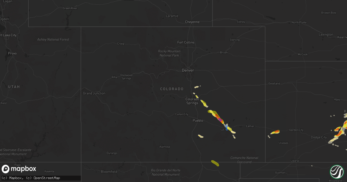
Hail Map in Colorado on September 14, 2021
Get this storm
September 14 map
$229
one time, instant access
Download today. No call, no setup
Keep the $229
Bought the map and want the full workflow? Apply the entire $229 to a subscription within 7 days. None of it is wasted.
Every map, not just this one
This buys you this map. Subscription and you get every map we run, in the markets you choose from a few cities to whole states to nationwide. Plus real-time alerts the moment a storm fires.
Contact data
Name, contact info, occupancy, even credit band for addresses in the footprint. You go from where it hit to who to call.
Become the source they trust
Unlimited branding weather history reports on demand. You already have the documented answer ready for the property owner, and you are the one who showed up with it.
Property data and RoofTrace estimates
Pull up any address you have got, its value and the exact code rules for that jurisdiction, straight from One Click Code. Then RoofTrace estimates the squares, pitch, and roof value, priced the way you price.
Storm reports in Colorado
Colorado
| Date | Description |
|---|---|
| 09/14/20216:45 PM CDT | 2-3 inch limbs of trees snapped off of healthy trees - green growth was noted on the limbs. Metal siding and roofing debris reported scattered around ordway. |
| 09/14/20214:50 PM CDT | Winds of 50 mph or greater was also observed. |
| 09/14/20213:45 PM CDT | Hail was mixed with pea to quarter size... Possibly larger. |
| 09/14/20211:20 AM CDT | At 618 PM MDT, severe thunderstorms were located along a line extending from near North La Junta to near Blue Lake, moving east at 30 mph. HAZARD...70 mph wind gusts and quarter size hail. SOURCE...La Junta automated weather sensor measured 70 mph winds. IMPACT...Hail damage to vehicles is expected. Expect considerable tree damage. Wind damage is also likely to mobile homes, roofs, and outbuildings. Severe thunderstorms will be near... Blue Lake around 625 PM MDT.Other locations in the path of these severe thunderstorms includeHasty. |
| 09/14/20211:13 AM CDT | At 612 PM MDT, a severe thunderstorm was located near Trinchera, or 19 miles northwest of Des Moines, moving southeast at 20 mph. HAZARD...60 mph wind gusts and quarter size hail. SOURCE...Radar indicated. IMPACT...Hail damage to vehicles is expected. Expect wind damage to roofs, siding, and trees. Locations impacted include... Des Moines, Folsom and Capulin. This includes Highway 64 between Mile Markers 376 and 389. |
| 09/14/20211:09 AM CDT | At 609 PM MDT, a severe thunderstorm was located near Trinchera, or 21 miles northwest of Des Moines, moving east at 20 mph. HAZARD...60 mph wind gusts and quarter size hail. SOURCE...Radar indicated. IMPACT...Hail damage to vehicles is expected. Expect wind damage to roofs, siding, and trees. Locations impacted include... Branson. |
| 09/14/202112:45 AM CDT | At 544 PM MDT, a severe thunderstorm was located over Sugar City, or 18 miles northwest of La Junta, moving southeast at 20 mph. HAZARD...Two inch hail and 60 mph wind gusts. SOURCE...Radar indicated. IMPACT...People and animals outdoors will be injured. Expect hail damage to roofs, siding, windows, and vehicles. Expect wind damage to roofs, siding, and trees. Locations impacted include... Rocky Ford, Cheraw, Swink, La Junta and North La Junta. |
| 09/13/202111:58 PM CDT | At 457 PM MDT, a severe thunderstorm was located 14 miles northwest of Crowley, or 35 miles northwest of La Junta, moving southeast at 30 mph. HAZARD...Golf ball size hail and 60 mph wind gusts. SOURCE...Radar indicated. IMPACT...People and animals outdoors will be injured. Expect hail damage to roofs, siding, windows, and vehicles. Expect wind damage to roofs, siding, and trees. Locations impacted include... Crowley, Ordway and Sugar City. |
| 09/13/202111:46 PM CDT | At 446 PM MDT, a severe thunderstorm was located 7 miles north of Trinidad, moving southeast at 45 mph. HAZARD...60 mph wind gusts and quarter size hail. SOURCE...Radar indicated. IMPACT...Hail damage to vehicles is expected. Expect wind damage to roofs, siding, and trees. This severe thunderstorm will be near... Trinidad, Starkville and Hoehne around 455 PM MDT.Other locations in the path of this severe thunderstorm includeTrinchera. |
| 09/13/202111:17 PM CDT | At 416 PM MDT, a severe thunderstorm was located 7 miles northeast of Hanover, or 28 miles east of Colorado Springs, moving southeast at 25 mph. HAZARD...60 mph wind gusts and half dollar size hail. SOURCE...Radar indicated. IMPACT...Hail damage to vehicles is expected. Expect wind damage to roofs, siding, and trees. This severe thunderstorm will be near... Truckton around 425 PM MDT. |
| 09/13/202110:32 PM CDT | At 332 PM MDT, a severe thunderstorm was located near Schriever AFB, or 18 miles east of Colorado Springs, moving southeast at 30 mph. HAZARD...60 mph wind gusts and quarter size hail. SOURCE...Radar indicated. IMPACT...Hail damage to vehicles is expected. Expect wind damage to roofs, siding, and trees. This severe thunderstorm will be near... Ellicott around 345 PM MDT.Other locations in the path of this severe thunderstorm include Yoderand Truckton. |
| 09/13/20219:59 PM CDT | At 258 PM MDT, a severe thunderstorm was located over Black Forest, or 13 miles northeast of Colorado Springs, moving southeast at 15 mph. HAZARD...60 mph wind gusts and quarter size hail. SOURCE...Radar indicated. IMPACT...Hail damage to vehicles is expected. Expect wind damage to roofs, siding, and trees. This severe thunderstorm will be near... Falcon around 315 PM MDT. |
| 09/13/20219:33 PM CDT | At 233 PM MDT, a severe thunderstorm was located near Black Forest, or 15 miles north of Colorado Springs, moving southeast at 20 mph. HAZARD...Quarter size hail. SOURCE...Radar indicated. IMPACT...Damage to vehicles is expected. This severe thunderstorm will be near... Black Forest around 245 PM MDT. |
| 09/13/20219:08 PM CDT | At 207 PM MDT, a severe thunderstorm was located 4 miles northwest of Elbert, or 28 miles north of Colorado Springs, moving east at 20 mph. HAZARD...60 mph wind gusts and quarter size hail. SOURCE...Radar indicated. IMPACT...Expect damage to roofs, siding, and trees. Hail damage to vehicles is expected. This severe thunderstorm will be near... Elbert around 220 PM MDT.Other locations in the path of this severe thunderstorm includeKiowa. |
| 09/13/20217:25 PM CDT | Downed tree branches reported across la junta according to law enforcement. |
| 09/13/20217:15 PM CDT | Small limbs broken off of healthy elm trees. |
| 09/13/20217:14 PM CDT | A local report indicates 70 MPH wind near 4 S CHERAW |
All States Impacted by Hail Map on September 14, 2021
Cities Impacted by Hail Map on September 14, 2021
- Lyons, OH
- Wauseon, OH
- Fowlerville, MI
- Converse, IN
- Marion, IN
- La Fontaine, IN
- Hoisington, KS
- Claflin, KS
- Great Bend, KS
- Walsenburg, CO
- Colorado Springs, CO
- Upton, WY
- Sturgis, MI
- White Pigeon, MI
- Constantine, MI
- Danville, IN
- Pendleton, IN
- Sandusky, MI
- Deckerville, MI
- Carsonville, MI
- Port Sanilac, MI
- Medina, OH
- Fenton, MI
- Howell, MI
- Cass City, MI
- Ubly, MI
- Muncie, IN
- Gaston, IN
- Yorktown, IN
- Alexandria, IN
- Marlette, MI
- Brown City, MI
- Peru, IN
- Herrick, IL
- Lakewood, IL
- Beecher City, IL
- Tower Hill, IL
- Cowden, IL
- Macksville, KS
- Haviland, KS
- Lewis, KS
- Hartland, MI
- Brighton, MI
- Highland, MI
- Hudson, MI
- Pittsford, MI
- Osseo, MI
- Gate, OK
- Middletown, IN
- La Junta, CO
- Elmore, OH
- Graytown, OH
- North Adams, MI
- Calhan, CO
- Yoder, CO
- Kinsley, KS
- Belpre, KS
- Las Animas, CO
- Denver, IN
- Terre Haute, IN
- Pawnee Rock, KS
- Larned, KS
- Shipshewana, IN
- Holyrood, KS
- Bushton, KS
- Lorraine, KS
- Cunningham, KS
- Kingman, KS
- Ordway, CO
- New Paris, IN
- Goshen, IN
- Daleville, IN
- Wabash, IN
- Coldwater, MI
- Quincy, MI
- Reading, MI
- Peyton, CO
- Marquette, KS
- Stafford, KS
- Walnut, KS
- Erie, KS
- Saint Paul, KS
- Niles, MI
- Edwardsburg, MI
- Vandalia, MI
- Cassopolis, MI
- Eagle, MI
- Harbor Springs, MI
- Louisville, IL
- Clay City, IL
- Sugar City, CO
- Mooreland, IN
- Springport, IN
- New Castle, IN
- Little River, KS
- Lindsborg, KS
- Windom, KS
- Dieterich, IL
- Wheeler, IL
- Newton, IL
- Hillsboro, IL
- Coffeen, IL
- Donnellson, IL
- Washington, MO
- Milton, KS
- Argonia, KS
- Norwich, KS
- Kingman, IN
- Bainbridge, IN
- Greencastle, IN
- Fillmore, IN
- Coatesville, IN
- Ceresco, MI
- Battle Creek, MI
- Marshall, MI
- Greensburg, KS
- Elbert, CO
- Franktown, CO
- Elizabeth, CO
- Losantville, IN
- Sterling, KS
- Lyons, KS
- Kewanna, IN
- Burnettsville, IN
- Lucerne, IN
- Royal Center, IN
- Albert, KS
- Moorcroft, WY
- Greenville, IL
- Garfield, KS
- Williamston, MI
- Okemos, MI
- Mason, MI
- Hagerstown, IN
- Kendall, KS
- St John, KS
- Kokomo, IN
- Collinsville, IL
- Hartford, IL
- Granite City, IL
- Maryville, IL
- Edwardsville, IL
- Glen Carbon, IL
- Amboy, IN
- Van Buren, IN
- Swayzee, IN
- Saint Ignace, MI
- Mackinac Island, MI
- Bellevue, MI
- Deepwater, MO
- Clinton, MO
- Syracuse, KS
- Millington, MI
- Vassar, MI
- Frankfort, IN
- Mount Hope, KS
- Colwich, KS
- Andale, KS
- Bad Axe, MI
- Sandoval, IL
- Carlyle, IL
- Centralia, IL
- Mcpherson, KS
- Ellsworth, KS
- Mason, IL
- Edgewood, IL
- Farina, IL
- Lerna, IL
- Trilla, IL
- Iola, KS
- Yates Center, KS
- Humboldt, KS
- Piqua, KS
- Onaway, MI
- Cambridge City, IN
- Jones, MI
- Granger, IN
- South Bend, IN
- Kinmundy, IL
- Alma, IL
- Sun City, KS
- Howe, IN
- Charlotte, MI
- Olivet, MI
- Eaton Rapids, MI
- Springport, MI
- West Liberty, IL
- Greentown, IN
- Sweetser, IN
- Vermontville, MI
- Anderson, IN
- Union City, MI
- Athens, MI
- New Haven, MO
- Logansport, IN
- Walton, IN
- Lafayette, IN
- Westpoint, IN
- Jewett, IL
- Effingham, IL
- Montrose, IL
- Markleville, IN
- Summitville, IN
- Amo, IN
- Sedgwick, KS
- Webberville, MI
- Dansville, MI
- Palms, MI
- Ruth, MI
- Detroit, MI
- Dearborn, MI
- Birch Run, MI
- Montrose, MI
- Chesaning, MI
- Burt, MI
- Sylvania, OH
- Berkey, OH
- Holland, OH
- Swanton, OH
- Metamora, OH
- Knightstown, IN
- Clayton, IN
- Middlebury, IN
- Boone, CO
- Idaville, IN
- Delphi, IN
- Twelve Mile, IN
- Cheraw, CO
- Kiowa, CO
- Saint Louis, MO
- Andrews, IN
- Huntington, IN
- Lagro, IN
- Caro, MI
- Decker, MI
- Deford, MI
- Belleville, IL
- Clarks Hill, IN
- Ingraham, IL
- Sailor Springs, IL
- Olney Springs, CO
- Rogers City, MI
- Manitou Beach, MI
- Addison, MI
- Fairmount, IN
- Xenia, IL
- Whitestown, IN
- Lebanon, IN
- Hillsdale, MI
- Burr Oak, MI
- Hume, IL
- Litchfield, MI
- Perrysville, IN
- Bunker Hill, IN
- Miami, IN
- Grissom Arb, IN
- Macy, IN
- Roann, IN
- Warren, IN
- Galveston, IN
- Newman, IL
- Offerle, KS
- Fostoria, MI
- Three Rivers, MI
- Jonesville, MI
- Allen, MI
- Spivey, KS
- Mayville, MI
- Clayton, MI
- Warrenton, MO
- Goodrich, MI
- Rocky Ford, CO
- East Leroy, MI
- Martinsville, IN
- Morgantown, IN
- Perry, MI
- Dearborn Heights, MI
- Garden City, MI
- Westland, MI
- Inkster, MI
- Perrysburg, OH
- Genoa, OH
- Woodville, OH
- Mullinville, KS
- Bucklin, KS
- Holly, MI
- Linden, MI
- Cloverdale, IN
- Putnamville, IN
- Jasper, MI
- Thorntown, IN
- Patoka, IL
- Odin, IL
- Hoffman, IL
- Central Lake, MI
- East Jordan, MI
- Boyne City, MI
- Monrovia, IN
- Mooresville, IN
- Monument, CO
- Jackson, MI
- Millstadt, IL
- Smithton, IL
- Freeburg, IL
- Mascoutah, IL
- Ellinwood, KS
- Notre Dame, IN
- Mishawaka, IN
- West Unity, OH
- Fayette, OH
- Archbold, OH
- Jonesboro, IN
- Dunbridge, OH
- Bowling Green, OH
- Geneseo, KS
- Pratt, KS
- Rochester, IN
- Bonnots Mill, MO
- Chamois, MO
- Applegate, MI
- Peck, MI
- Bridgeport, MI
- Frankenmuth, MI
- Linn, MO
- Flora, IN
- Camden, IN
- Wyandotte, MI
- Ecorse, MI
- Lincoln Park, MI
- Southgate, MI
- Colfax, IN
- Albers, IL
- New Baden, IL
- Indianapolis, IN
- Greenwood, IN
- Nekoma, KS
- Rush Center, KS
- Clifford, MI
- North Branch, MI
- Turon, KS
- Levering, MI
- Romulus, MI
- Flat Rock, MI
- Brownsburg, IN
- Pittsboro, IN
- Gays, IL
- Windsor, IL
- Toledo, OH
- Maumee, OH
- Monclova, OH
- Fremont, OH
- Oak Harbor, OH
- Port Clinton, OH
- Metcalf, IL
- Chrisman, IL
- Steedman, MO
- Portland, MO
- Bentley, KS
- Halstead, KS
- Tebbetts, MO
- Alexander, KS
- Silverwood, MI
- Pellston, MI
- Fulton, MI
- Vicksburg, MI
- Leonidas, MI
- Mendon, MI
- Sherwood, MI
- Colon, MI
- Harbor Beach, MI
- Millersburg, IN
- Lagrange, IN
- Topeka, IN
- Bristol, IN
- Leslie, MO
- Latham, KS
- Montrose, MO
- Wolverine, MI
- Osceola, MO
- Whiteland, IN
- Minden City, MI
- Royal Oak, MI
- Madison Heights, MI
- Troy, MI
- Sterling Heights, MI
- Oak Park, MI
- Berkley, MI
- Clawson, MI
- Southfield, MI
- Indian River, MI
- Cheboygan, MI
- Afton, MI
- Millersburg, MI
- Trinchera, CO
- Folsom, NM
- Raton, NM
- Haskins, OH
- Clay Center, OH
- Northwood, OH
- Rocky Ridge, OH
- Oregon, OH
- McClure, OH
- Waterville, OH
- Walbridge, OH
- Stony Ridge, OH
- Weston, OH
- Luckey, OH
- Rossford, OH
- Tontogany, OH
- Curtice, OH
- Pemberville, OH
- Martin, OH
- Millbury, OH
- Grand Rapids, OH
- Sylvia, KS
- Lakin, KS


