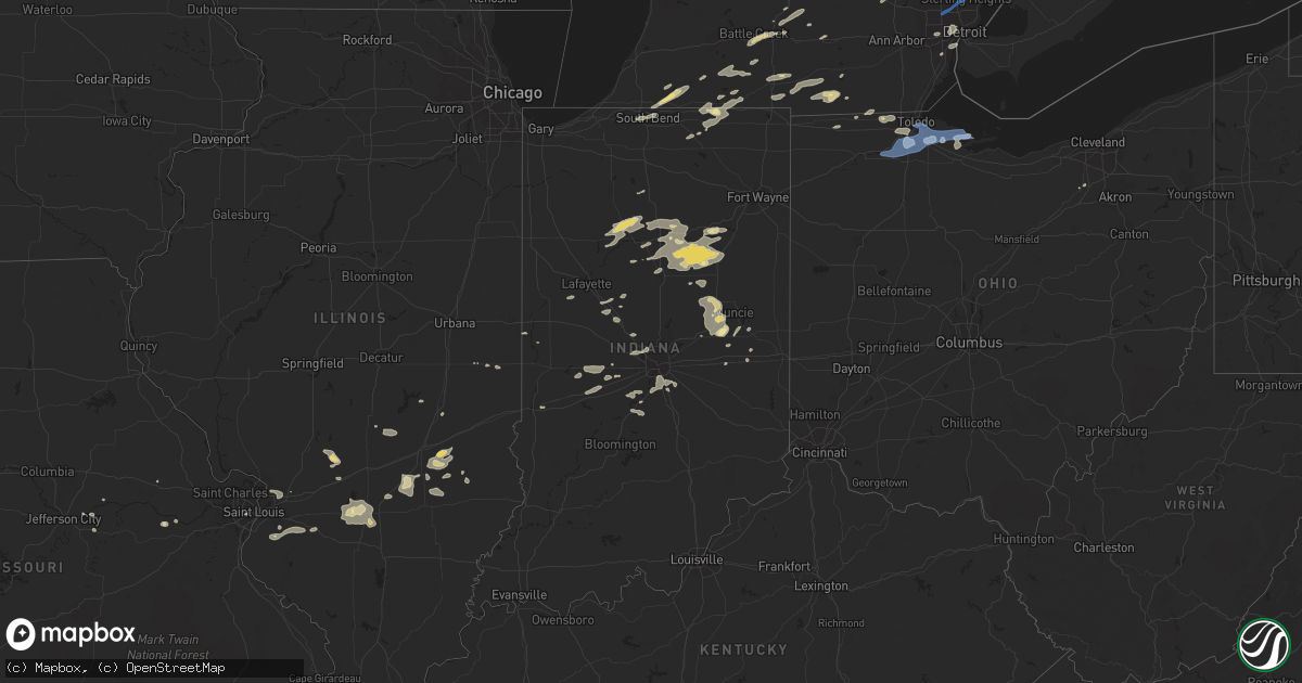
Hail Map in Indiana on September 14, 2021
Get this storm
September 14 map
$229
one time, instant access
Download today. No call, no setup
Keep the $229
Bought the map and want the full workflow? Apply the entire $229 to a subscription within 7 days. None of it is wasted.
Every map, not just this one
This buys you this map. Subscription and you get every map we run, in the markets you choose from a few cities to whole states to nationwide. Plus real-time alerts the moment a storm fires.
Contact data
Name, contact info, occupancy, even credit band for addresses in the footprint. You go from where it hit to who to call.
Become the source they trust
Unlimited branding weather history reports on demand. You already have the documented answer ready for the property owner, and you are the one who showed up with it.
Property data and RoofTrace estimates
Pull up any address you have got, its value and the exact code rules for that jurisdiction, straight from One Click Code. Then RoofTrace estimates the squares, pitch, and roof value, priced the way you price.
Storm reports in Indiana
Indiana
| Date | Description |
|---|---|
| 09/14/20216:35 PM CDT | Several 6-8” live limbs broken & a few 8-12” live trees down. Also about 1/2 mile of corn blown down along the road. |
| 09/14/20216:35 PM CDT | Several 6-8 inch live limbs broken & a few 8-12 inch live trees down. Also about 1/2 mile of corn blown down along the road. |
| 09/14/20215:48 PM CDT | Trees and powerlines down. Time estimated by radar. |
| 09/14/20215:47 AM CDT | At 1047 PM EDT, a severe thunderstorm was located 9 miles northwest of New Castle, or 11 miles southeast of Anderson, moving east at 20 mph. HAZARD...60 mph wind gusts and quarter size hail. SOURCE...Radar indicated. IMPACT...Hail damage to vehicles is expected. Expect wind damage to roofs, siding, and trees. This severe thunderstorm will be near... Cadiz around 1050 PM EDT. Sulphur Springs around 1055 PM EDT. Springport around 1100 PM EDT. Mount Summit around 1105 PM EDT.Other locations in the path of this severe thunderstorm include NewCastle, Mooreland, Blountsville and Summit Lake State Park.This includes Interstate 70 near mile marker 133. |
| 09/14/20215:28 AM CDT | At 1027 PM EDT, a severe thunderstorm was located near Muncie, moving east at 25 mph. HAZARD...60 mph wind gusts and quarter size hail. SOURCE...Radar indicated. IMPACT...Hail damage to vehicles is expected. Expect wind damage to roofs, siding, and trees. This severe thunderstorm will be near... Prairie Creek Reservoir around 1045 PM EDT.Other locations in the path of this severe thunderstorm includeSelma. |
| 09/14/20213:46 AM CDT | At 846 PM EDT, a severe thunderstorm was located over Marion, moving east at 30 mph. HAZARD...60 mph wind gusts and penny size hail. SOURCE...Law enforcement. IMPACT...Expect damage to roofs, siding, and trees. Locations impacted include... Marion, Hartford City, Gas City, Upland, Montpelier, Jonesboro, Sweetser, Swayzee, Van Buren, Sims, Converse, Poneto, Mcnatts, Landess, Mount Zion, Mier, Herbst, Keystone, Roseburg and Home Corner.This includes Interstate 69 in Indiana between mile markers 257 and271. |
| 09/14/20211:31 AM CDT | At 631 PM EDT, a severe thunderstorm was located 10 miles southwest of Rochester, moving northeast at 40 mph. HAZARD...60 mph wind gusts and penny size hail. SOURCE...Radar indicated. IMPACT...Expect damage to roofs, siding, and trees. Locations impacted include... Rochester, Akron, Fulton, Macy, Nyena Lake, Leases Corner, Deedsville, Athens, Twelve Mile, Metea, Grass Creek, Fletcher, Lake Manitou, Gilead, Lucerne and Marshtown. |
| 09/13/202111:28 PM CDT | At 427 PM EDT, a severe thunderstorm was located over Edwardsburg, moving northeast at 45 mph. HAZARD...60 mph wind gusts and quarter size hail. SOURCE...Radar indicated. IMPACT...Hail damage to vehicles is expected. Expect wind damage to roofs, siding, and trees. Locations impacted include... Constantine, White Pigeon, Three Rivers, Centreville and Colon. |
| 09/13/20219:29 PM CDT | Tree limbs one inch in diameter broken. Shingles blown off. |
| 09/13/20219:25 PM CDT | Late report of power lines down. Time estimated by radar. |
| 09/13/20219:23 PM CDT | Tree down at county road 100 north and county road 500 west. |
| 09/13/20217:41 PM CDT | Tree across road. |
| 09/13/20217:05 PM CDT | Multiple trees and tree limbs blown down in south-central huntington county. Time estimated by radar. |
All States Impacted by Hail Map on September 14, 2021
Cities Impacted by Hail Map on September 14, 2021
- Lyons, OH
- Wauseon, OH
- Fowlerville, MI
- Converse, IN
- Marion, IN
- La Fontaine, IN
- Hoisington, KS
- Claflin, KS
- Great Bend, KS
- Walsenburg, CO
- Colorado Springs, CO
- Upton, WY
- Sturgis, MI
- White Pigeon, MI
- Constantine, MI
- Danville, IN
- Pendleton, IN
- Sandusky, MI
- Deckerville, MI
- Carsonville, MI
- Port Sanilac, MI
- Medina, OH
- Fenton, MI
- Howell, MI
- Cass City, MI
- Ubly, MI
- Muncie, IN
- Gaston, IN
- Yorktown, IN
- Alexandria, IN
- Marlette, MI
- Brown City, MI
- Peru, IN
- Herrick, IL
- Lakewood, IL
- Beecher City, IL
- Tower Hill, IL
- Cowden, IL
- Macksville, KS
- Haviland, KS
- Lewis, KS
- Hartland, MI
- Brighton, MI
- Highland, MI
- Hudson, MI
- Pittsford, MI
- Osseo, MI
- Gate, OK
- Middletown, IN
- La Junta, CO
- Elmore, OH
- Graytown, OH
- North Adams, MI
- Calhan, CO
- Yoder, CO
- Kinsley, KS
- Belpre, KS
- Las Animas, CO
- Denver, IN
- Terre Haute, IN
- Pawnee Rock, KS
- Larned, KS
- Shipshewana, IN
- Holyrood, KS
- Bushton, KS
- Lorraine, KS
- Cunningham, KS
- Kingman, KS
- Ordway, CO
- New Paris, IN
- Goshen, IN
- Daleville, IN
- Wabash, IN
- Coldwater, MI
- Quincy, MI
- Reading, MI
- Peyton, CO
- Marquette, KS
- Stafford, KS
- Walnut, KS
- Erie, KS
- Saint Paul, KS
- Niles, MI
- Edwardsburg, MI
- Vandalia, MI
- Cassopolis, MI
- Eagle, MI
- Harbor Springs, MI
- Louisville, IL
- Clay City, IL
- Sugar City, CO
- Mooreland, IN
- Springport, IN
- New Castle, IN
- Little River, KS
- Lindsborg, KS
- Windom, KS
- Dieterich, IL
- Wheeler, IL
- Newton, IL
- Hillsboro, IL
- Coffeen, IL
- Donnellson, IL
- Washington, MO
- Milton, KS
- Argonia, KS
- Norwich, KS
- Kingman, IN
- Bainbridge, IN
- Greencastle, IN
- Fillmore, IN
- Coatesville, IN
- Ceresco, MI
- Battle Creek, MI
- Marshall, MI
- Greensburg, KS
- Elbert, CO
- Franktown, CO
- Elizabeth, CO
- Losantville, IN
- Sterling, KS
- Lyons, KS
- Kewanna, IN
- Burnettsville, IN
- Lucerne, IN
- Royal Center, IN
- Albert, KS
- Moorcroft, WY
- Greenville, IL
- Garfield, KS
- Williamston, MI
- Okemos, MI
- Mason, MI
- Hagerstown, IN
- Kendall, KS
- St John, KS
- Kokomo, IN
- Collinsville, IL
- Hartford, IL
- Granite City, IL
- Maryville, IL
- Edwardsville, IL
- Glen Carbon, IL
- Amboy, IN
- Van Buren, IN
- Swayzee, IN
- Saint Ignace, MI
- Mackinac Island, MI
- Bellevue, MI
- Deepwater, MO
- Clinton, MO
- Syracuse, KS
- Millington, MI
- Vassar, MI
- Frankfort, IN
- Mount Hope, KS
- Colwich, KS
- Andale, KS
- Bad Axe, MI
- Sandoval, IL
- Carlyle, IL
- Centralia, IL
- Mcpherson, KS
- Ellsworth, KS
- Mason, IL
- Edgewood, IL
- Farina, IL
- Lerna, IL
- Trilla, IL
- Iola, KS
- Yates Center, KS
- Humboldt, KS
- Piqua, KS
- Onaway, MI
- Cambridge City, IN
- Jones, MI
- Granger, IN
- South Bend, IN
- Kinmundy, IL
- Alma, IL
- Sun City, KS
- Howe, IN
- Charlotte, MI
- Olivet, MI
- Eaton Rapids, MI
- Springport, MI
- West Liberty, IL
- Greentown, IN
- Sweetser, IN
- Vermontville, MI
- Anderson, IN
- Union City, MI
- Athens, MI
- New Haven, MO
- Logansport, IN
- Walton, IN
- Lafayette, IN
- Westpoint, IN
- Jewett, IL
- Effingham, IL
- Montrose, IL
- Markleville, IN
- Summitville, IN
- Amo, IN
- Sedgwick, KS
- Webberville, MI
- Dansville, MI
- Palms, MI
- Ruth, MI
- Detroit, MI
- Dearborn, MI
- Birch Run, MI
- Montrose, MI
- Chesaning, MI
- Burt, MI
- Sylvania, OH
- Berkey, OH
- Holland, OH
- Swanton, OH
- Metamora, OH
- Knightstown, IN
- Clayton, IN
- Middlebury, IN
- Boone, CO
- Idaville, IN
- Delphi, IN
- Twelve Mile, IN
- Cheraw, CO
- Kiowa, CO
- Saint Louis, MO
- Andrews, IN
- Huntington, IN
- Lagro, IN
- Caro, MI
- Decker, MI
- Deford, MI
- Belleville, IL
- Clarks Hill, IN
- Ingraham, IL
- Sailor Springs, IL
- Olney Springs, CO
- Rogers City, MI
- Manitou Beach, MI
- Addison, MI
- Fairmount, IN
- Xenia, IL
- Whitestown, IN
- Lebanon, IN
- Hillsdale, MI
- Burr Oak, MI
- Hume, IL
- Litchfield, MI
- Perrysville, IN
- Bunker Hill, IN
- Miami, IN
- Grissom Arb, IN
- Macy, IN
- Roann, IN
- Warren, IN
- Galveston, IN
- Newman, IL
- Offerle, KS
- Fostoria, MI
- Three Rivers, MI
- Jonesville, MI
- Allen, MI
- Spivey, KS
- Mayville, MI
- Clayton, MI
- Warrenton, MO
- Goodrich, MI
- Rocky Ford, CO
- East Leroy, MI
- Martinsville, IN
- Morgantown, IN
- Perry, MI
- Dearborn Heights, MI
- Garden City, MI
- Westland, MI
- Inkster, MI
- Perrysburg, OH
- Genoa, OH
- Woodville, OH
- Mullinville, KS
- Bucklin, KS
- Holly, MI
- Linden, MI
- Cloverdale, IN
- Putnamville, IN
- Jasper, MI
- Thorntown, IN
- Patoka, IL
- Odin, IL
- Hoffman, IL
- Central Lake, MI
- East Jordan, MI
- Boyne City, MI
- Monrovia, IN
- Mooresville, IN
- Monument, CO
- Jackson, MI
- Millstadt, IL
- Smithton, IL
- Freeburg, IL
- Mascoutah, IL
- Ellinwood, KS
- Notre Dame, IN
- Mishawaka, IN
- West Unity, OH
- Fayette, OH
- Archbold, OH
- Jonesboro, IN
- Dunbridge, OH
- Bowling Green, OH
- Geneseo, KS
- Pratt, KS
- Rochester, IN
- Bonnots Mill, MO
- Chamois, MO
- Applegate, MI
- Peck, MI
- Bridgeport, MI
- Frankenmuth, MI
- Linn, MO
- Flora, IN
- Camden, IN
- Wyandotte, MI
- Ecorse, MI
- Lincoln Park, MI
- Southgate, MI
- Colfax, IN
- Albers, IL
- New Baden, IL
- Indianapolis, IN
- Greenwood, IN
- Nekoma, KS
- Rush Center, KS
- Clifford, MI
- North Branch, MI
- Turon, KS
- Levering, MI
- Romulus, MI
- Flat Rock, MI
- Brownsburg, IN
- Pittsboro, IN
- Gays, IL
- Windsor, IL
- Toledo, OH
- Maumee, OH
- Monclova, OH
- Fremont, OH
- Oak Harbor, OH
- Port Clinton, OH
- Metcalf, IL
- Chrisman, IL
- Steedman, MO
- Portland, MO
- Bentley, KS
- Halstead, KS
- Tebbetts, MO
- Alexander, KS
- Silverwood, MI
- Pellston, MI
- Fulton, MI
- Vicksburg, MI
- Leonidas, MI
- Mendon, MI
- Sherwood, MI
- Colon, MI
- Harbor Beach, MI
- Millersburg, IN
- Lagrange, IN
- Topeka, IN
- Bristol, IN
- Leslie, MO
- Latham, KS
- Montrose, MO
- Wolverine, MI
- Osceola, MO
- Whiteland, IN
- Minden City, MI
- Royal Oak, MI
- Madison Heights, MI
- Troy, MI
- Sterling Heights, MI
- Oak Park, MI
- Berkley, MI
- Clawson, MI
- Southfield, MI
- Indian River, MI
- Cheboygan, MI
- Afton, MI
- Millersburg, MI
- Trinchera, CO
- Folsom, NM
- Raton, NM
- Haskins, OH
- Clay Center, OH
- Northwood, OH
- Rocky Ridge, OH
- Oregon, OH
- McClure, OH
- Waterville, OH
- Walbridge, OH
- Stony Ridge, OH
- Weston, OH
- Luckey, OH
- Rossford, OH
- Tontogany, OH
- Curtice, OH
- Pemberville, OH
- Martin, OH
- Millbury, OH
- Grand Rapids, OH
- Sylvia, KS
- Lakin, KS


