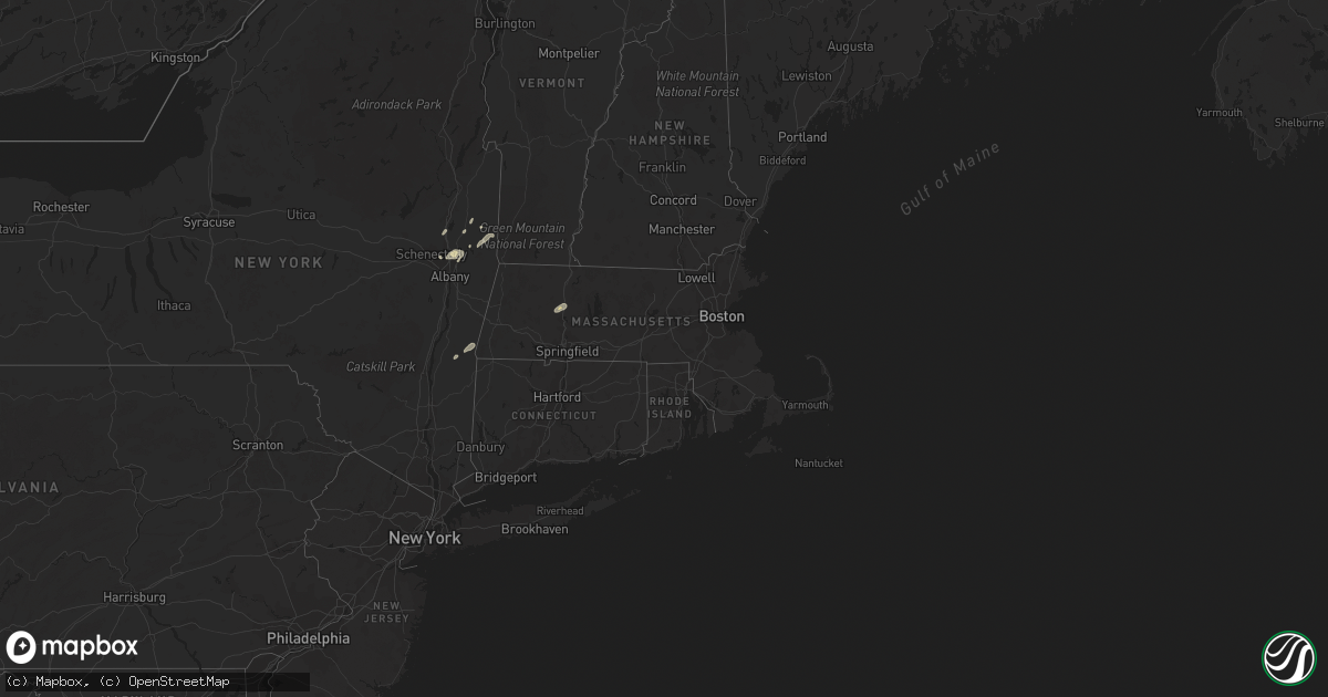
Hail Map in Massachusetts on September 13, 2022
Get this storm
September 13 map
$229
one time, instant access
Download today. No call, no setup
Keep the $229
Bought the map and want the full workflow? Apply the entire $229 to a subscription within 7 days. None of it is wasted.
Every map, not just this one
This buys you this map. Subscription and you get every map we run, in the markets you choose from a few cities to whole states to nationwide. Plus real-time alerts the moment a storm fires.
Contact data
Name, contact info, occupancy, even credit band for addresses in the footprint. You go from where it hit to who to call.
Become the source they trust
Unlimited branding weather history reports on demand. You already have the documented answer ready for the property owner, and you are the one who showed up with it.
Property data and RoofTrace estimates
Pull up any address you have got, its value and the exact code rules for that jurisdiction, straight from One Click Code. Then RoofTrace estimates the squares, pitch, and roof value, priced the way you price.
Storm reports in Massachusetts
Massachusetts
| Date | Description |
|---|---|
| 09/13/20226:14 PM CDT | Multiple trees down on wires on shutesbury road |
| 09/13/20226:11 PM CDT | Trees and power lines down on millers falls road |
| 09/13/20223:00 AM CDT | At 800 PM EDT, a severe thunderstorm was located over Sharon, or near Jaffrey, moving east at 20 mph. HAZARD...60 mph wind gusts and penny size hail. SOURCE...Radar indicated. IMPACT...Expect damage to roofs, siding, and trees. Locations impacted include... Nashua, Merrimack, Jaffrey, Bedford, Milford, Amherst, Hollis, Peterborough, New Boston, Mont Vernon, Greenfield, Lyndeborough, Dublin, Francestown, Bennington, Harrisville, Rindge, Hancock, Sharon and New Ipswich. |
| 09/13/20222:08 AM CDT | At 707 PM EDT, a severe thunderstorm was located near Richmond, or 15 miles southwest of Jaffrey, moving northeast at 30 mph. HAZARD...60 mph wind gusts and penny size hail. SOURCE...Radar indicated. IMPACT...Expect damage to roofs, siding, and trees. Locations impacted include... Jaffrey, Swanzey, Peterborough, Winchester, Antrim, Marlborough, Greenfield, Lyndeborough, Dublin, Bennington, Richmond, Harrisville, Rindge, Hancock, Sharon, New Ipswich, Greenville, Fitzwilliam, Troy and Temple. |
| 09/13/20221:53 AM CDT | At 652 PM EDT, a severe thunderstorm was located over Northfield, or 8 miles northwest of Orange, moving northeast at 55 mph. HAZARD...60 mph wind gusts. SOURCE...Radar indicated. IMPACT...Expect damage to trees and power lines. Locations impacted include... Northfield, Bernardston, Erving, Gill, Royalston and Warwick. |
| 09/13/202212:43 AM CDT | At 543 PM EDT, a severe thunderstorm was located near Otis, or 13 miles east of Great Barrington, moving east at 30 mph. HAZARD...60 mph wind gusts and quarter size hail. SOURCE...Radar indicated. IMPACT...Expect wind damage to trees and power lines. Minor hail damage to vehicles is possible. Locations impacted include... Holyoke, Northampton, South Hadley, Easthampton, Granby, Southampton, Hadley, Hatfield, Williamsburg, Huntington, Russell, Westhampton, Whately, Chester, Blandford, Chesterfield, Worthington, Goshen, Montgomery and Middlefield. |
| 09/13/202212:04 AM CDT | At 504 PM EDT, a severe thunderstorm was located near Copake, or 8 miles southwest of Great Barrington, moving east at 35 mph. HAZARD...60 mph wind gusts and nickel size hail. SOURCE...Radar indicated. IMPACT...Expect damage to roofs, siding, and trees. Locations impacted include... Great Barrington, Lee, Copake, Sheffield, Becket, Otis, Sandisfield, Housatonic, Ashley Falls, Hillsdale, New Marlborough, Monterey, Alford, Tyringham, Ancramdale, Hartsville, Konkapot, Gomorrah, Montville and Alander. |
| 09/12/20227:27 PM CDT | Trees down on jewett hill road and flint road |
All States Impacted by Hail Map on September 13, 2022
Cities Impacted by Hail Map on September 13, 2022
- Cohoes, NY
- Waterford, NY
- Leupp, AZ
- Clewiston, FL
- Tombstone, AZ
- South Deerfield, MA
- Hatfield, MA
- North Hatfield, MA
- West Hatfield, MA
- Haydenville, MA
- Chino Valley, AZ
- Troy, NY
- San Simon, AZ
- Valley Falls, NY
- Elfrida, AZ
- Holbrook, AZ
- Nespelem, WA
- Jordan Valley, OR
- Paulden, AZ
- Winslow, AZ
- Joseph City, AZ
- Johnsonville, NY
- Buskirk, NY
- Eagle Bridge, NY
- Hoosick Falls, NY
- Douglas, AZ
- Schenectady, NY
- Greenwich, NY
- Ancram, NY
- Copake Falls, NY
- Copake, NY
- Hillsdale, NY
- East Wenatchee, WA
- Pine Plains, NY
- Mechanicville, NY
- Ballston Lake, NY
- Ballston Spa, NY
- Cambridge, NY
- Clifton Park, NY
- Latham, NY
- Melrose, NY
- Rexford, NY
- Schaghticoke, NY


