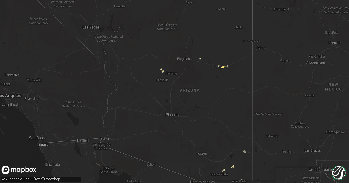
Hail Map in Arizona on September 13, 2022
Get this storm
September 13 map
$229
one time, instant access
Download today. No call, no setup
Keep the $229
Bought the map and want the full workflow? Apply the entire $229 to a subscription within 7 days. None of it is wasted.
Every map, not just this one
This buys you this map. Subscription and you get every map we run, in the markets you choose from a few cities to whole states to nationwide. Plus real-time alerts the moment a storm fires.
Contact data
Name, contact info, occupancy, even credit band for addresses in the footprint. You go from where it hit to who to call.
Become the source they trust
Unlimited branding weather history reports on demand. You already have the documented answer ready for the property owner, and you are the one who showed up with it.
Property data and RoofTrace estimates
Pull up any address you have got, its value and the exact code rules for that jurisdiction, straight from One Click Code. Then RoofTrace estimates the squares, pitch, and roof value, priced the way you price.
Storm reports in Arizona
Arizona
| Date | Description |
|---|---|
| 09/13/20221:46 PM CDT | A local report indicates 1.75 inch wind near 3 NE HOLBROOK |
| 09/13/20221:45 PM CDT | Public report of quarter size hail just north of holbrook. A picture was provided on social media. |
| 09/13/20221:00 PM CDT | Landspout tornado observed to have briefly touched down south of the little colorado river where the dust was seen swirling. |
| 09/13/20227:01 AM CDT | At 1201 PM MST, a severe thunderstorm was located 8 miles east of Huachuca City, or 9 miles north of Sierra Vista, moving northeast at 10 mph. HAZARD...60 mph wind gusts and quarter size hail. SOURCE...Radar indicated. IMPACT...Hail damage to vehicles is expected. Expect wind damage to roofs, siding, and trees. Locations impacted include... Sierra Vista, Benson, Whetstone, Huachuca City, St. David, Tombstone, Kartchner Caverns State Park, Fairbank and Charleston. |
| 09/13/20226:36 AM CDT | At 1135 AM MST, a severe thunderstorm was located over Holbrook, or 31 miles east of Winslow, moving northeast at 10 mph. HAZARD...60 mph wind gusts and quarter size hail. SOURCE...Radar indicated. IMPACT...Hail damage to vehicles is expected. Expect wind damage to roofs, siding, and trees. Locations impacted include... Holbrook and Sun Valley. This includes the following highways... Business Interstate 40 between mile markers 286 and 289. Interstate 40 between mile markers 284 and 299. State Route 377 near mile marker 33. State Route 77 between mile markers 384 and 404. Highway 180 between mile markers 308 and 313. |
| 09/13/20225:27 AM CDT | At 1027 AM MST, a severe thunderstorm was located near Paulden, or near Chino Valley, moving north at 5 mph. HAZARD...Quarter size hail. SOURCE...Radar indicated. IMPACT...Damage to vehicles is expected. Locations impacted include... Chino Valley and Paulden. This includes State Route 89 between mile markers 328 and 344. |
| 09/12/20229:12 PM CDT | At 211 PM MST, a severe thunderstorm was located over Douglas, moving northeast at 15 mph. HAZARD...60 mph wind gusts and quarter size hail. SOURCE...Radar indicated. IMPACT...Hail damage to vehicles is expected. Expect wind damage to roofs, siding, and trees. Locations impacted include... Douglas, Bisbee-Douglas Airport and Pirtleville. |
| 09/12/20229:02 PM CDT | At 202 PM MDT, a severe thunderstorm was located 8 miles northwest of Joseph City, or 14 miles east of Winslow, moving northeast at 15 mph. HAZARD...60 mph wind gusts and quarter size hail. SOURCE...Radar indicated. IMPACT...Hail damage to vehicles is expected. Expect wind damage to roofs, siding, and trees. This severe thunderstorm will remain over mainly rural areas of Navajo County.This includes Interstate 40 between mile markers 263 and 274. |
| 09/12/20228:55 PM CDT | At 155 PM MST, a severe thunderstorm was located near Leupp, or 22 miles northwest of Winslow, moving northeast at 15 mph. HAZARD...60 mph wind gusts and quarter size hail. SOURCE...Radar indicated. IMPACT...Hail damage to vehicles is expected. Expect wind damage to roofs, siding, and trees. Locations impacted include... Rimmy Jims, Sunrise and Leupp. This includes State Route 99 between mile markers 63 and 71. |
| 09/12/20228:18 PM CDT | At 118 PM MST, a severe thunderstorm was located 11 miles southeast of Pearce-Sunsites, or 28 miles north of Bisbee, moving northeast at 15 mph. HAZARD...60 mph wind gusts and quarter size hail. SOURCE...Radar indicated. IMPACT...Hail damage to vehicles is expected. Expect wind damage to roofs, siding, and trees. Locations impacted include... Pearce-Sunsites, Elfrida, Sunizona and Kansas Settlement. |
| 09/12/20227:45 PM CDT | Gustnado observed to have formed and traveled along the leading edge of thunderstorm outflow. |
All States Impacted by Hail Map on September 13, 2022
Cities Impacted by Hail Map on September 13, 2022
- Cohoes, NY
- Waterford, NY
- Leupp, AZ
- Clewiston, FL
- Tombstone, AZ
- South Deerfield, MA
- Hatfield, MA
- North Hatfield, MA
- West Hatfield, MA
- Haydenville, MA
- Chino Valley, AZ
- Troy, NY
- San Simon, AZ
- Valley Falls, NY
- Elfrida, AZ
- Holbrook, AZ
- Nespelem, WA
- Jordan Valley, OR
- Paulden, AZ
- Winslow, AZ
- Joseph City, AZ
- Johnsonville, NY
- Buskirk, NY
- Eagle Bridge, NY
- Hoosick Falls, NY
- Douglas, AZ
- Schenectady, NY
- Greenwich, NY
- Ancram, NY
- Copake Falls, NY
- Copake, NY
- Hillsdale, NY
- East Wenatchee, WA
- Pine Plains, NY
- Mechanicville, NY
- Ballston Lake, NY
- Ballston Spa, NY
- Cambridge, NY
- Clifton Park, NY
- Latham, NY
- Melrose, NY
- Rexford, NY
- Schaghticoke, NY


