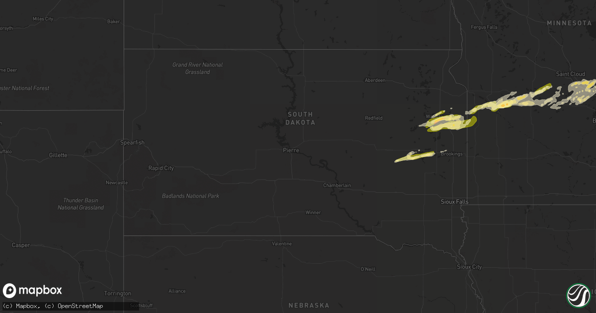
Hail Map in South Dakota on September 8, 2022
Get this storm
September 8 map
$229
one time, instant access
Download today. No call, no setup
Keep the $229
Bought the map and want the full workflow? Apply the entire $229 to a subscription within 7 days. None of it is wasted.
Every map, not just this one
This buys you this map. Subscription and you get every map we run, in the markets you choose from a few cities to whole states to nationwide. Plus real-time alerts the moment a storm fires.
Contact data
Name, contact info, occupancy, even credit band for addresses in the footprint. You go from where it hit to who to call.
Become the source they trust
Unlimited branding weather history reports on demand. You already have the documented answer ready for the property owner, and you are the one who showed up with it.
Property data and RoofTrace estimates
Pull up any address you have got, its value and the exact code rules for that jurisdiction, straight from One Click Code. Then RoofTrace estimates the squares, pitch, and roof value, priced the way you price.
Storm reports in South Dakota
South Dakota
| Date | Description |
|---|---|
| 09/08/20226:11 AM CDT | At 1111 PM CDT, a severe thunderstorm was located over Clear Lake, moving east at 40 mph. HAZARD...60 mph wind gusts and quarter size hail. SOURCE...Radar indicated. IMPACT...Hail damage to vehicles is expected. Expect wind damage to roofs, siding, and trees. This severe thunderstorm will be near... Gary around 1125 PM CDT.Other locations in the path of this severe thunderstorm includeCanby. |
| 09/08/20226:06 AM CDT | At 1106 PM CDT, a severe thunderstorm was located near Oldham, or 7 miles east of Lake Thompson State Recreation Area, moving east at 35 mph. HAZARD...Quarter size hail. SOURCE...Radar indicated. IMPACT...Damage to vehicles is expected. This severe thunderstorm will be near... Hetland around 1115 PM CDT. Arlington and Badger around 1120 PM CDT. Sinai around 1125 PM CDT.Other locations in the path of this severe thunderstorm includeOakwood State Park, Volga, Brookings and Bruce. |
| 09/08/20225:34 AM CDT | At 1034 PM CDT, a severe thunderstorm was located near Carthage, or 10 miles southwest of Lake Thompson State Recreation Area, moving east at 35 mph. HAZARD...Quarter size hail. SOURCE...Radar indicated. IMPACT...Damage to vehicles is expected. This severe thunderstorm will be near... De Smet around 1045 PM CDT. Lake Thompson State Recreation Area around 1050 PM CDT.Other locations in the path of this severe thunderstorm include LakePreston, Oldham, Hetland, Arlington and Badger. |
| 09/08/20225:07 AM CDT | At 1007 PM CDT, a severe thunderstorm was located over Naples, or 11 miles north of Bryant, moving northeast at 40 mph. HAZARD...Half dollar size hail. SOURCE...Radar indicated. IMPACT...Damage to vehicles is expected. This severe thunderstorm will be near... Hazel around 1015 PM CDT. Tinkertown around 1020 PM CDT. Goose Lake and Thomas around 1025 PM CDT.Other locations in the path of this severe thunderstorm include LakeKampeska, Sandy Shore Rec Area, Memorial Park Camping Site,Watertown, Pelican Lake, Watertown City Park, Rauville and Kranzburg. |
| 09/07/202211:15 PM CDT | Estimated dime to quarter size hail. |
| 09/07/202210:55 PM CDT | Estimated dime to quarter size hail. |
| 09/07/202210:31 PM CDT | Relayed via social media with photo. Approximate time and location. |
| 09/07/202210:00 PM CDT | Approximate time and location. |
| 09/07/20229:35 PM CDT | A local report indicates 1.25 inch wind near 3 ESE RAUVILLE |
| 09/07/20229:27 PM CDT | Radar-estimated time. |
All States Impacted by Hail Map on September 8, 2022
Cities Impacted by Hail Map on September 8, 2022
- Tivoli, TX
- Mason, WI
- Seligman, AZ
- Lake Preston, SD
- Goodwin, SD
- Cushing, WI
- North Branch, MN
- Harris, MN
- Saint Croix Falls, WI
- Grantsburg, WI
- Spicer, MN
- Atwater, MN
- New London, MN
- Paynesville, MN
- Willmar, MN
- Elk River, MN
- Raymond, MN
- Kerkhoven, MN
- Benson, MN
- Dawson, MN
- Montevideo, MN
- Maynard, MN
- Madison, MN
- Watson, MN
- Milan, MN
- Murdock, MN
- Pennock, MN
- Danvers, MN
- Appleton, MN
- Strandburg, SD
- Cokato, MN
- Orlando, FL
- Howard Lake, MN
- Annandale, MN
- Cambridge, MN
- Cavour, SD
- Taft, TX
- Princeton, MN
- Becker, MN
- Victoria, TX
- Maple Lake, MN
- Monticello, MN
- Big Lake, MN
- Dassel, MN
- Litchfield, MN
- Grove City, MN
- Buffalo, MN
- Volga, SD
- Minong, WI
- Isanti, MN
- Saint Francis, MN
- Anoka, MN
- Cedar, MN
- Stacy, MN
- Wyoming, MN
- Bethel, MN
- South Haven, MN
- Darwin, MN
- Eden Valley, MN
- De Smet, SD
- Carthage, SD
- Watertown, SD
- Tampa, FL
- Thonotosassa, FL
- Wesley Chapel, FL
- Zephyrhills, FL
- Clear Lake, SD
- Portland, TX
- Oldham, SD
- Arlington, SD
- Iroquois, SD
- Artesian, SD
- Port Saint Lucie, FL
- Waverly, MN
- Watkins, MN
- Kimball, MN
- Sunburg, MN
- Gary, SD
- Kandiyohi, MN
- Revillo, SD
- Marietta, MN
- Clara City, MN
- Clear Lake, MN
- Saint Michael, MN
- Montrose, MN
- Clearwater, MN
- Andover, MN
- Zimmerman, MN
- Albertville, MN
- Luck, WI
- Brandt, SD
- Vienna, SD
- Kranzburg, SD
- Hazel, SD
- Castlewood, SD
- Canby, MN
- Hayti, SD
- Bayside, TX
- Rockport, TX


