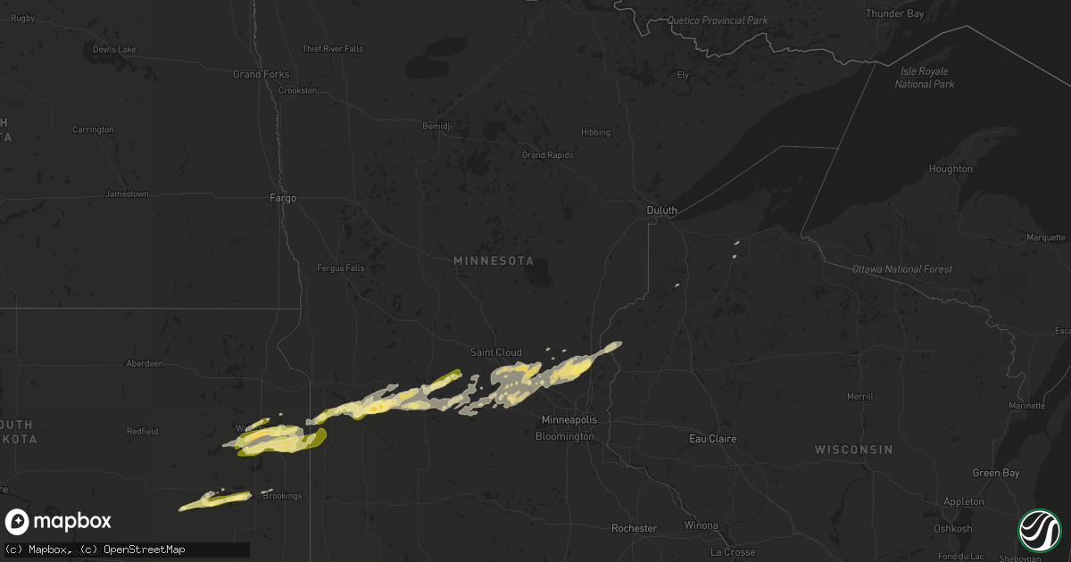
Hail Map in Minnesota on September 8, 2022
Get this storm
September 8 map
$229
one time, instant access
Download today. No call, no setup
Keep the $229
Bought the map and want the full workflow? Apply the entire $229 to a subscription within 7 days. None of it is wasted.
Every map, not just this one
This buys you this map. Subscription and you get every map we run, in the markets you choose from a few cities to whole states to nationwide. Plus real-time alerts the moment a storm fires.
Contact data
Name, contact info, occupancy, even credit band for addresses in the footprint. You go from where it hit to who to call.
Become the source they trust
Unlimited branding weather history reports on demand. You already have the documented answer ready for the property owner, and you are the one who showed up with it.
Property data and RoofTrace estimates
Pull up any address you have got, its value and the exact code rules for that jurisdiction, straight from One Click Code. Then RoofTrace estimates the squares, pitch, and roof value, priced the way you price.
Storm reports in Minnesota
Minnesota
| Date | Description |
|---|---|
| 09/08/20226:55 AM CDT | At 1155 PM CDT, a severe thunderstorm was located 8 miles northeast of Watson, or 8 miles north of Montevideo, moving east at 35 mph. HAZARD...Ping pong ball size hail. SOURCE...Radar indicated. IMPACT...People and animals outdoors will be injured. Expect damage to roofs, siding, windows, and vehicles. This severe thunderstorm will remain over mainly rural areas of northeastern Chippewa and southeastern Swift Counties. |
| 09/08/20226:10 AM CDT | At 1110 PM CDT, a severe thunderstorm was located over Brandt, or near Clear Lake, moving east at 45 mph. HAZARD...60 mph wind gusts and quarter size hail. SOURCE...Radar indicated. IMPACT...Hail damage to vehicles is expected. Expect wind damage to roofs, siding, and trees. This severe thunderstorm will be near... Lake Cochrane Rec Area around 1120 PM CDT. |
| 09/08/20225:46 AM CDT | At 1046 PM CDT, a severe thunderstorm was located near Madison, or 22 miles southeast of Ortonville, moving east at 35 mph. HAZARD...Ping pong ball size hail. SOURCE...Radar indicated. IMPACT...People and animals outdoors will be injured. Expect damage to roofs, siding, windows, and vehicles. This severe thunderstorm will be near... Madison around 1050 PM CDT. |
| 09/08/20225:34 AM CDT | At 1034 PM CDT, a severe thunderstorm was located near Pelican Lake, or near Castlewood, moving northeast at 40 mph. HAZARD...Ping pong ball size hail and 60 mph wind gusts. SOURCE...Radar indicated. IMPACT...People and animals outdoors will be injured. Expect hail damage to roofs, siding, windows, and vehicles. Expect wind damage to roofs, siding, and trees. This severe thunderstorm will be near... Kranzburg around 1045 PM CDT. Goodwin and Bemis around 1050 PM CDT.Other locations in the path of this severe thunderstorm includeSchool Lake, Bullhead Lake, Altamont, Tunerville, Lake Alice, LaBolt, Revillo and Albee. |
| 09/08/20225:00 AM CDT | At 958 PM CDT, a severe thunderstorm was located over Strandburg, or 14 miles southwest of Milbank, moving northeast at 40 mph. HAZARD...Half dollar size hail. SOURCE...Radar indicated. At 935 pm CDT, half dollar size hail was reported 3 mile ESE of Rauville. IMPACT...Damage to vehicles is expected. This severe thunderstorm will be near... Revillo and Albee around 1010 PM CDT. |
| 09/08/202212:45 AM CDT | A local report indicates 1.00 inch wind near PAYNESVILLE |
| 09/07/202210:51 PM CDT | Multiple reports of quarter size hail in madison. |
All States Impacted by Hail Map on September 8, 2022
Cities Impacted by Hail Map on September 8, 2022
- Tivoli, TX
- Mason, WI
- Seligman, AZ
- Lake Preston, SD
- Goodwin, SD
- Cushing, WI
- North Branch, MN
- Harris, MN
- Saint Croix Falls, WI
- Grantsburg, WI
- Spicer, MN
- Atwater, MN
- New London, MN
- Paynesville, MN
- Willmar, MN
- Elk River, MN
- Raymond, MN
- Kerkhoven, MN
- Benson, MN
- Dawson, MN
- Montevideo, MN
- Maynard, MN
- Madison, MN
- Watson, MN
- Milan, MN
- Murdock, MN
- Pennock, MN
- Danvers, MN
- Appleton, MN
- Strandburg, SD
- Cokato, MN
- Orlando, FL
- Howard Lake, MN
- Annandale, MN
- Cambridge, MN
- Cavour, SD
- Taft, TX
- Princeton, MN
- Becker, MN
- Victoria, TX
- Maple Lake, MN
- Monticello, MN
- Big Lake, MN
- Dassel, MN
- Litchfield, MN
- Grove City, MN
- Buffalo, MN
- Volga, SD
- Minong, WI
- Isanti, MN
- Saint Francis, MN
- Anoka, MN
- Cedar, MN
- Stacy, MN
- Wyoming, MN
- Bethel, MN
- South Haven, MN
- Darwin, MN
- Eden Valley, MN
- De Smet, SD
- Carthage, SD
- Watertown, SD
- Tampa, FL
- Thonotosassa, FL
- Wesley Chapel, FL
- Zephyrhills, FL
- Clear Lake, SD
- Portland, TX
- Oldham, SD
- Arlington, SD
- Iroquois, SD
- Artesian, SD
- Port Saint Lucie, FL
- Waverly, MN
- Watkins, MN
- Kimball, MN
- Sunburg, MN
- Gary, SD
- Kandiyohi, MN
- Revillo, SD
- Marietta, MN
- Clara City, MN
- Clear Lake, MN
- Saint Michael, MN
- Montrose, MN
- Clearwater, MN
- Andover, MN
- Zimmerman, MN
- Albertville, MN
- Luck, WI
- Brandt, SD
- Vienna, SD
- Kranzburg, SD
- Hazel, SD
- Castlewood, SD
- Canby, MN
- Hayti, SD
- Bayside, TX
- Rockport, TX


