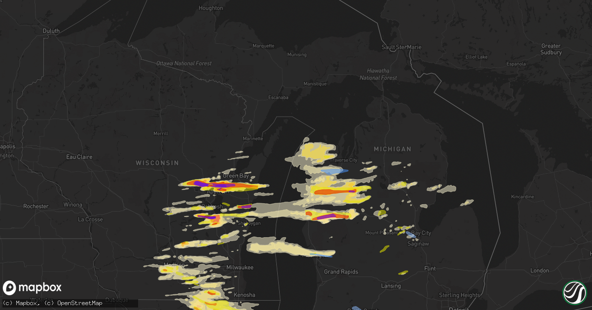
Hail Map in Michigan on September 7, 2021
Get this storm
September 7 map
$229
one time, instant access
Download today. No call, no setup
Keep the $229
Bought the map and want the full workflow? Apply the entire $229 to a subscription within 7 days. None of it is wasted.
Every map, not just this one
This buys you this map. Subscription and you get every map we run, in the markets you choose from a few cities to whole states to nationwide. Plus real-time alerts the moment a storm fires.
Contact data
Name, contact info, occupancy, even credit band for addresses in the footprint. You go from where it hit to who to call.
Become the source they trust
Unlimited branding weather history reports on demand. You already have the documented answer ready for the property owner, and you are the one who showed up with it.
Property data and RoofTrace estimates
Pull up any address you have got, its value and the exact code rules for that jurisdiction, straight from One Click Code. Then RoofTrace estimates the squares, pitch, and roof value, priced the way you price.
Storm reports in Michigan
Michigan
| Date | Description |
|---|---|
| 09/07/20216:55 PM CDT | Roof blown off house. Pole barn and farm silo destroyed. |
| 09/07/20216:47 PM CDT | Trees downed... Some onto buildings. Power lines and poles downed. |
| 09/07/20216:47 PM CDT | Trees down blocking the road. Location is approximate. Time estimated from radar. |
| 09/07/20216:46 PM CDT | Trees and power poles/lines downed. |
| 09/07/20216:40 PM CDT | Several large trees down over the road. Via spotter network. Times estimated from radar. |
| 09/07/20215:25 PM CDT | Several reports of trees down in leoni township especially at hawkins road and dalton road. |
| 09/07/20215:20 PM CDT | Multiple trees down at webster and drumheller road in bath township. |
| 09/07/20215:15 PM CDT | Tree down at business 127 and herbison road. |
| 09/07/20215:05 PM CDT | Tree down at gibbs road and town road. |
| 09/07/20215:05 PM CDT | Tree across road in riley township. |
| 09/07/20214:32 PM CDT | Public reports of several large diameter limbs down as well as a few trees around mackinaw and tittabawssee roads. Broadcast media also relayed images of large uprooted |
| 09/07/20214:21 PM CDT | Asos station kbtl battle creek executive airport. |
| 09/07/20214:20 PM CDT | Tree on house on collier avenue with multiple trees down in neighborhood. Courtesy of wwmt. |
| 09/07/20214:15 PM CDT | Trained spotter reports trees down and power outages around the city of vassar. |
| 09/07/20214:06 PM CDT | Asos station kazo kzoo/battle creek intl airport. |
| 09/07/20214:06 PM CDT | Numerous trees and power lines down in texas twp... One resulting in a house fire. Time estimated from radar. |
| 09/07/20214:05 PM CDT | Structure collapse due to fallen tree. One person trapped in house; no injuries. Time estimated from radar. |
| 09/07/20214:00 PM CDT | Trained spotter estimated 60 mph winds. Time estimated via radar. |
| 09/07/20213:45 PM CDT | Media relayed damage photos via social media of damage in carrollton. |
| 09/07/20213:40 PM CDT | 6 trees downed across roadway. 2 reports of power lines downed. |
| 09/07/20213:35 PM CDT | Photo of large limb down across road and adjacent power line. Relayed via social media from wwmt tv. Time estimated from radar. |
| 09/07/20213:26 PM CDT | Large tree fallen onto 26th ave between 66th and 63rd. Time estimated from radar. |
| 09/07/20213:21 PM CDT | Emergency manager reports a few trees down in northern berrien county. Estimated time and estimated location. |
| 09/07/20213:21 PM CDT | Public reports photos of two trees and several branches down near fishers lake and m60. |
| 09/07/20213:20 PM CDT | Dispatch reports several trees and power lines down near owendale and ivanhoe. |
| 09/07/20213:15 PM CDT | Correction to fishers lake report. Reports of trees and tree limbs north of three rivers near the intersection of heimbach and wilbur roads. |
| 09/07/20212:48 PM CDT | Measured at mbs international airport. |
| 09/07/20212:46 PM CDT | Photo of large tree down across millbrook rd. Between s. Lincoln and s. Crawford....via social media. |
| 09/07/20212:45 PM CDT | 6 to 8 inch limbs down. |
| 09/07/20212:36 PM CDT | At intersection of state rd and lincoln rd. |
| 09/07/20212:32 PM CDT | Media relayed photos a few large trees down in the linwood area. |
| 09/07/20212:31 PM CDT | Several large tree branches down... Some across road. Relayed via social media photos. |
| 09/07/20212:31 PM CDT | Relayed via social media images. |
| 09/07/20212:30 PM CDT | Multiple trees and wires down near chrystal... Mi. |
| 09/07/20212:25 PM CDT | Multiple trees and wires down in vestaburg... Mi. |
| 09/07/20212:18 PM CDT | Several reports of quarter sized hail from amateur radio. |
| 09/07/20212:15 PM CDT | Dispatch reports numerous trees and power lines down in larkin township. |
| 09/07/20212:00 PM CDT | Photo of 30-inch-diameter fallen tree at the nelson cemetery...via social media. Time estimated from radar. |
| 09/07/20212:00 PM CDT | Photo of 26-inch-diameter tree across road...relayed via social media. Time estimated from radar. |
| 09/07/20211:55 PM CDT | Trees down on power lines. |
| 09/07/20211:54 PM CDT | Video of widespread tree damage...relayed via 9 & 10 news. Time estimated from radar. |
| 09/07/20211:43 PM CDT | Trees down on power lines. |
| 09/07/20211:38 PM CDT | Photo of limbs down on cmu campus...related via social media. Time estimated from radar. |
| 09/07/20211:35 PM CDT | Photo of snapped tree limbs on social media...relayed via wzzm. Time estimated from radar. |
| 09/07/20211:20 PM CDT | Damage to cardinal elementary school. Large tree uprooted and large branches on ground from various trees. Roof above the cafeteria and gym damaged... Causing flooding |
| 09/07/20211:17 PM CDT | Photo of very large oak tree uprooted. Relayed via social media from wood tv. Time estimated from radar. |
| 09/07/20211:17 PM CDT | Photo of uprooted tree on campus of baker college in muskegon...relayed via social media from wood tv. Time estimated from radar. |
| 09/07/20211:14 PM CDT | Areas of trees and wires down across hayes township. |
| 09/07/20211:11 PM CDT | Trees and wires down at lake george avenue and arthur ave. Multiple trees and wires down around lake george. |
| 09/07/20211:08 PM CDT | Photo of hailstones via social media. |
| 09/07/20211:00 PM CDT | Tree broken and heavy metal swing blown over. Time estimated 2pm. |
| 09/07/202112:57 PM CDT | Photos of large trees downed in evart...relayed on social media via wpbn news. Time estimated from radar. |
| 09/07/202112:53 PM CDT | A local report indicates 1.00 inch wind near REED CITY |
| 09/07/202112:53 PM CDT | Trees and power poles snapped...nickel-sized hail also observed. |
| 09/07/202112:52 PM CDT | Numerous photos of wind damage between reed city and evart... Including uprooted tree fallen on home... And snapped utility pole. Relayed via 9 & 10 news...time estimat |
| 09/07/202112:45 PM CDT | Photos of numerous large limbs down on homes and wires on the north side of reed city...related via wpbn news. Time estimated from radar. |
| 09/07/202112:43 PM CDT | Damage to trees and power lines. Torn roof of wesco gas station awning in reed city. |
| 09/07/202112:31 PM CDT | Photo of hailstones... Along with limbs down...via social media. Time estimated from radar. |
| 09/07/202112:20 PM CDT | Photo of 2.5-inch hail...via social media. |
| 09/07/202112:14 PM CDT | A local report indicates 1.00 inch wind near CUSTER |
| 09/07/202112:11 PM CDT | A local report indicates 1.25 inch wind near 2 SE SCOTTVILLE |
| 09/07/202112:00 PM CDT | A local report indicates 2.00 inch wind near 5 SE LUDINGTON |
| 09/07/202111:58 AM CDT | Time estimated from radar. |
| 09/07/202111:33 AM CDT | A local report indicates 1.00 inch wind near 1 ENE CADILLAC |
| 09/07/202111:25 AM CDT | A local report indicates 2.00 inch wind near 1 ENE CADILLAC |
| 09/07/202110:50 AM CDT | A local report indicates 1.75 inch wind near 1 SW WELLSTON |
| 09/07/202110:45 AM CDT | A local report indicates 1.50 inch wind near 5 WSW BRETHREN |
| 09/07/202110:42 AM CDT | Report from mping: quarter |
| 09/07/20218:30 AM CDT | Power lines down on road. Time of damage estimated from radar. |
| 09/07/20218:26 AM CDT | Multiple trees down. |
| 09/07/20218:23 AM CDT | Power lines down on road. Time of damage estimated from radar. |
| 09/07/20217:54 AM CDT | At 1254 PM EDT, a severe thunderstorm was located near Silver Lake SP, or 8 miles west of Hart, moving east at 55 mph. HAZARD...60 mph wind gusts and penny size hail. SOURCE...Radar indicated. IMPACT...Expect damage to roofs, siding, and trees. Locations impacted include... Hart... Shelby... Hesperia... Pentwater... Mears SP... Silver Lake SP... Weare... Elbridge... Colfax... New Era... Rothbury... Walkerville... St. Huberts... Stony Lake... Crystal Valley... |
| 09/07/20217:32 AM CDT | At 1231 PM EDT, a severe thunderstorm was located 6 miles southeast of Dublin, or 14 miles north of Baldwin, moving east at 55 mph. HAZARD...60 mph wind gusts and penny size hail. SOURCE...Radar indicated. IMPACT...Expect damage to roofs, siding, and trees. Locations impacted include... Marion... Luther... Highland... Le Roy... Tustin... Wolf Lake... Ashton... Irons... Bristol... Sauble Lakes... Avondale... Dighton... |
| 09/07/20217:28 AM CDT | At 1228 PM EDT, a severe thunderstorm was located near Jennings, or near Cadillac, moving east at 50 mph. HAZARD...Ping pong ball size hail and 60 mph wind gusts. SOURCE...Trained weather spotters. IMPACT...People and animals outdoors will be injured. Expect hail damage to roofs, siding, windows, and vehicles. Expect wind damage to roofs, siding, and trees. This severe thunderstorm will be near... Lake City and Morey around 1235 PM EDT.Other locations in the path of this severe thunderstorm includeMoorestown, Houghton Lake, Higgins Lake and North Higgins Lake. |
| 09/07/20217:25 AM CDT | At 1225 PM EDT, a severe thunderstorm was located 7 miles west of Ludington SP, moving east at 55 mph. HAZARD...60 mph wind gusts and quarter size hail. SOURCE...Radar indicated. IMPACT...Hail damage to vehicles is expected. Expect wind damage to roofs, siding, and trees. Locations impacted include... Ludington... Ludington SP... Scottville... Fountain... Free Soil... Hamlin Lake... Custer... Walhalla... |
| 09/07/20217:08 AM CDT | At 1208 PM EDT, a severe thunderstorm was located over Rifle River State Park, or 15 miles northeast of West Branch, moving east at 45 mph. HAZARD...60 mph wind gusts and quarter size hail. SOURCE...Radar indicated. IMPACT...Hail damage to vehicles is expected. Expect wind damage to roofs, siding, and trees. This severe thunderstorm will be near... Long Lake around 1215 PM EDT. Hale around 1220 PM EDT. Plainfield Township around 1225 PM EDT.Other locations in the path of this severe thunderstorm includeMikado, Wurtsmith Airfield, Oscoda and Au Sable. |
| 09/07/20217:00 AM CDT | At 1200 PM EDT, a severe thunderstorm was located over Eastlake, or near Manistee, moving east at 55 mph. HAZARD...Ping pong ball size hail and 60 mph wind gusts. SOURCE...Radar indicated. IMPACT...People and animals outdoors will be injured. Expect hail damage to roofs, siding, windows, and vehicles. Expect wind damage to roofs, siding, and trees. This severe thunderstorm will be near... Norwalk around 1205 PM EDT. Kaleva, Brethren, Wellston and Dublin around 1215 PM EDT. |
| 09/07/20216:56 AM CDT | At 1156 AM EDT, severe thunderstorms were located along a line extending from near Yuma to near Dublin, moving east at 65 mph. HAZARD...Two inch hail and 60 mph wind gusts. SOURCE...Trained spotter. At 1155 AM EDT, ping pong ball size hail was reported in Wellston. IMPACT...People and animals outdoors will be injured. Expect hail damage to roofs, siding, windows, and vehicles. Expect wind damage to roofs, siding, and trees. Severe thunderstorms will be near... Mesick and Yuma around 1200 PM EDT. Sherman, Harrietta and Hoxeyville around 1205 PM EDT. Boon and Meauwataka around 1210 PM EDT. Cadillac, Manton and Mitchell State Park around 1215 PM EDT.Other locations in the path of these severe thunderstorms includeLake City, Mcbain, Jennings, Morey, Lucas, Falmouth and Vogel Center. |
| 09/07/20216:30 AM CDT | At 1130 AM EDT, severe thunderstorms were located along a line extending from South Branch Township to near Lake St. Helen, moving east at 55 mph. HAZARD...60 mph wind gusts and quarter size hail. SOURCE...Radar indicated. IMPACT...Hail damage to vehicles is expected. Expect wind damage to roofs, siding, and trees. Severe thunderstorms will be near... Luzerne around 1140 AM EDT. Clear Lake around 1145 AM EDT. Mio, Rose City, Mack Lake and Selkirk around 1150 AM EDT.Other locations in the path of these severe thunderstorms includeLupton, Rose Township, Rifle River State Park, McKinley, Long Lake,South Branch and Curtisville. |
| 09/07/20216:28 AM CDT | At 1128 AM EDT, a severe thunderstorm was located over Sigma, or 9 miles southeast of Kalkaska, moving east at 55 mph. HAZARD...60 mph wind gusts and quarter size hail. SOURCE...Radar indicated. IMPACT...Hail damage to vehicles is expected. Expect wind damage to roofs, siding, and trees. This severe thunderstorm will be near... Grayling and Frederic around 1145 AM EDT.Other locations in the path of this severe thunderstorm includeHartwick Pines State Park and Lovells. |
| 09/07/20216:24 AM CDT | At 1124 AM EDT, severe thunderstorms were located along a line extending from 12 miles west of Arcadia to 11 miles northwest of Orchard Beach State Park to 6 miles west of Manistee to 10 miles west of Eastlake, moving east at 45 mph. HAZARD...60 mph wind gusts and quarter size hail. SOURCE...Radar indicated. IMPACT...Hail damage to vehicles is expected. Expect wind damage to roofs, siding, and trees. Severe thunderstorms will be near... Manistee, Eastlake, Parkdale and Orchard Beach State Park around 1135 AM EDT. Arcadia and Pierport around 1140 AM EDT.Other locations in the path of these severe thunderstorms includeOnekama, Norwalk, Wildwood, Bear Lake, Kaleva, Wellston, Brethren,Thompsonville, Copemish and Dublin. |
| 09/07/20216:06 AM CDT | At 1106 AM EDT, severe thunderstorms were located along a line extending from near Roscommon to near Roscommon County Airport to Moddersville, moving east at 45 mph. HAZARD...60 mph wind gusts. SOURCE...Radar indicated. IMPACT...Expect damage to roofs, siding, and trees. Severe thunderstorms will be near... Roscommon and South Higgins Lake around 1110 AM EDT. Lake St. Helen and South Branch Township around 1115 AM EDT. St. Helen and Roscommon Township around 1120 AM EDT.Other locations in the path of these severe thunderstorms includeClear Lake, Nester Township and Twin Lakes Area. |
| 09/07/20215:26 AM CDT | At 1026 AM EDT, a severe thunderstorm was located near Cadillac, moving east at 55 mph. HAZARD...60 mph wind gusts and quarter size hail. SOURCE...Radar indicated. IMPACT...Hail damage to vehicles is expected. Expect wind damage to roofs, siding, and trees. This severe thunderstorm will be near... Jennings around 1030 AM EDT. Lake City and Morey around 1035 AM EDT. Falmouth around 1040 AM EDT.Other locations in the path of this severe thunderstorm includeMoorestown. |
| 09/07/20214:29 AM CDT | At 928 AM EDT, severe thunderstorms were located along a line extending from Interlochen State Park to near Norwalk, moving east at 45 mph. HAZARD...60 mph wind gusts and quarter size hail. SOURCE...Radar indicated. At 913 EM EDT, penny size hail was reported 1 mile east of Beulah. IMPACT...Hail damage to vehicles is expected. Expect wind damage to roofs, siding, and trees. Severe thunderstorms will be near... Grawn, Interlochen, Interlochen State Park and Karlin around 935 AM EDT. Traverse City, Buckley and Hannah around 940 AM EDT. Kingsley around 945 AM EDT.Other locations in the path of these severe thunderstorms includeYuma, Spider Lake, Sherman, Mesick, Harrietta, Boon, Fife Lake, SouthBoardman, Meauwataka, Cadillac, Sharon, Mitchell State Park andJennings. |
| 09/07/20214:25 AM CDT | At 924 AM EDT, severe thunderstorms were located along a line extending from near Old Mission to near Grawn, moving east at 50 mph. HAZARD...60 mph wind gusts and quarter size hail. SOURCE...Law enforcement. At 920 AM EDT, trees down were reported by Grand Traverse law enforcement. IMPACT...Hail damage to vehicles is expected. Expect wind damage to roofs, siding, and trees. Severe thunderstorms will be near... Elk Rapids, Kewadin and Alden around 930 AM EDT. Clam River around 935 AM EDT. Bellaire and Williamsburg around 940 AM EDT.Other locations in the path of these severe thunderstorms includeMancelona, Antrim, Barker Creek, Kalkaska, Alba, Sigma and Darragh. |
| 09/07/20213:57 AM CDT | At 857 AM EDT, severe thunderstorms were located along a line extending from Frankfort to 13 miles northwest of Orchard Beach State Park, moving east at 55 mph. HAZARD...60 mph wind gusts and quarter size hail. SOURCE...Radar indicated. IMPACT...Hail damage to vehicles is expected. Expect wind damage to roofs, siding, and trees. Severe thunderstorms will be near... Frankfort and Elberta around 900 AM EDT. Beulah and Benzonia around 905 AM EDT. Honor, Pierport and Orchard Beach State Park around 910 AM EDT. Thompsonville, Onekama, Bear Lake, Norwalk and Wildwood around 915 AM EDT.Other locations in the path of these severe thunderstorms includeBendon, Kaleva, Interlochen State Park, Karlin, Brethren andInterlochen. |
| 09/07/20213:40 AM CDT | At 839 AM EDT, severe thunderstorms were located along a line extending from 9 miles north of Sleeping Bear Point to 6 miles west of Empire to 9 miles northwest of Frankfort, moving east at 40 mph. HAZARD...60 mph wind gusts and quarter size hail. SOURCE...Radar indicated. IMPACT...Hail damage to vehicles is expected. Expect wind damage to roofs, siding, and trees. Severe thunderstorms will be near... Empire and Glen Haven around 850 AM EDT. Burdickville around 855 AM EDT.Other locations in the path of these severe thunderstorms includeLeland, Platte Township, Maple City, Cedar, Lake Leelanau, SuttonsBay, Peshawbestown, Omena, Lake Ann, Fouch, Greilickville, TraverseCity and Interlochen. |
| 09/07/20212:55 AM CDT | At 754 PM EDT, a severe thunderstorm was located near Hillsdale, moving east at 55 mph. HAZARD...60 mph wind gusts and quarter size hail. SOURCE...Radar indicated. IMPACT...Hail damage to vehicles is expected. Expect wind damage to roofs, siding, and trees. This severe thunderstorm will be near... Hudson and Addison around 805 PM EDT. Clayton around 810 PM EDT. Adrian around 820 PM EDT. Blissfield around 830 PM EDT. Deerfield around 835 PM EDT.Other locations impacted by this severe thunderstorm include Seneca,Manitou Beach-Devils Lake, Macon, Lime Creek, Munson, Ogden Center,Canandaigua, Ridgeway, Palmyra and Tipton. |
| 09/07/20212:46 AM CDT | At 746 PM EDT, a severe thunderstorm was located over Jonesville, moving east at 50 mph. HAZARD...60 mph wind gusts and quarter size hail. SOURCE...Radar indicated. IMPACT...Hail damage to vehicles is expected. Expect wind damage to roofs, siding, and trees. Locations impacted include... Hillsdale, Jonesville, Litchfield, Jerome, Somerset, Moscow, North Adams, Allen and Somerset Center. |
| 09/07/20212:36 AM CDT | At 736 PM EDT, a severe thunderstorm was located near Laingsburg, moving northeast at 65 mph. HAZARD...60 mph wind gusts and quarter size hail. SOURCE...Radar indicated. IMPACT...Hail damage to vehicles is expected. Expect wind damage to roofs, siding, and trees. This severe thunderstorm will be near... Owosso around 740 PM EDT. Corunna and Henderson around 745 PM EDT. Durand around 750 PM EDT. New Lothrop and Lennon around 755 PM EDT.Other locations impacted by this severe thunderstorm includeJuddville, Bennington, Carland and Vernon. |
| 09/07/20211:01 AM CDT | At 601 PM EDT, a severe thunderstorm was located over Edgemont Park, or near Lansing, moving east at 50 mph. HAZARD...60 mph wind gusts. SOURCE...Radar indicated. IMPACT...Expect damage to roofs, siding, and trees. Locations impacted include... DeWitt... Ovid... Bath... |
| 09/07/202112:55 AM CDT | At 553 PM EDT, severe thunderstorms were located along a line extending from Waverly to near Eaton Rapids to 9 miles southwest of Leslie, moving east at 70 mph. HAZARD...60 mph wind gusts. SOURCE...Radar indicated. IMPACT...Expect damage to roofs, siding, and trees. Severe thunderstorms will be near... Laingsburg around 610 PM EDT. Perry, Morrice and Gregory around 615 PM EDT. Fowlerville, Pinckney and Bancroft around 620 PM EDT. Howell, Durand, Cohoctah, Byron and Oak Grove around 625 PM EDT. Brighton, Hamburg and Whitmore Lake around 630 PM EDT. Hartland around 635 PM EDT.Other locations impacted by these severe thunderstorms includePlainfield, Island Lake State Recreation Area, Conway Township,Vernon, Parkers Corners, Lakeland, Chilson, Bennington, Unadilla andShaftsburg. |
| 09/07/202112:40 AM CDT | At 537 PM EDT, severe thunderstorms were located along a line extending from 8 miles northwest of Potterville to 6 miles south of Charlotte to 5 miles northeast of Burlington, moving east at 60 mph. A wind gust to 69 mph was recorded at Kalamazoo with this line of storms, with 66 mph measured at Battle Creek. HAZARD...70 mph wind gusts. SOURCE...Radar indicated. IMPACT...Expect damage to roofs, siding, and trees. Locations impacted include... Lansing... Jackson... Mason... East Lansing... Williamston... Leslie... Stockbridge... Brooklyn... Grass Lake... Edgemont Park... Vandercook Lake... Leoni... Spring Arbor... Napoleon... Sandstone... Aurelius... Onondaga... Norvell... Bunker Hill... Pulaski... |
| 09/07/202112:24 AM CDT | At 523 PM EDT, severe thunderstorms were located along a line extending from near Vicksburg to near Centreville, moving east at 45 mph. HAZARD...60 mph wind gusts and quarter size hail. SOURCE...Radar indicated. IMPACT...Hail damage to vehicles is expected. Expect wind damage to roofs, siding, and trees. Locations impacted include... Bronson, Union City, Centreville, Colon, Nottawa, Leonidas, Mendon, Sherwood, Wasepi, Findley, Matteson Lake and Fairfax. |
| 09/07/202112:13 AM CDT | At 512 PM EDT, severe thunderstorms were located along a line extending from 5 miles northeast of Gull Lake to 5 miles southeast of Vicksburg, moving east at 60 mph. HAZARD...60 mph wind gusts. SOURCE...Radar indicated. IMPACT...Expect damage to roofs, siding, and trees. Locations impacted include... Charlotte... Albion... Marshall... Battle Creek... Eaton Rapids... Homer... Nashville... Bellevue... Burlington... Level Park-Oak Park... Brownlee Park... Marengo... Assyria... Kalamo... Olivet... Brookfield... Athens... Tekonsha... Pine Creek... Dowling... |
| 09/06/202111:49 PM CDT | At 448 PM EDT, a severe thunderstorm was located 6 miles west of Westwood, or 9 miles northwest of Kalamazoo, moving east at 55 mph. HAZARD...60 mph wind gusts and penny size hail. SOURCE...Radar indicated. IMPACT...Expect damage to roofs, siding, and trees. Locations impacted include... Kalamazoo... Portage... Otsego... Plainwell... Vicksburg... Galesburg... Schoolcraft... Climax... Richland... Martin... Westwood... Comstock Northwest... Gull Lake... Alamo... Orangeville... Fulton... Augusta... Delton... Oshtemo... Hickory Corners... |
| 09/06/202111:45 PM CDT | At 444 PM EDT, a severe thunderstorm was located over St. Charles, moving east at 60 mph. HAZARD...60 mph wind gusts and quarter size hail. SOURCE...Radar indicated. IMPACT...Hail damage to vehicles is expected. Expect wind damage to roofs, siding, and trees. This severe thunderstorm will be near... Bridgeport around 455 PM EDT. Birch Run around 500 PM EDT. Frankenmuth around 505 PM EDT.Other locations impacted by this severe thunderstorm include Brant,Nelson, Carrollton, Garfield, Arthur, Burt, Gera, Buena VistaTownship, Swan Creek and Shiawassee National Wildlife Refuge. |
| 09/06/202111:44 PM CDT | At 444 AM EDT, a severe thunderstorm was located 13 miles southeast of Skanee, or 20 miles east of L'anse, moving east at 50 mph. HAZARD...60 mph wind gusts and penny size hail. SOURCE...Radar indicated. IMPACT...Expect damage to roofs, siding, and trees. This severe thunderstorm will be near... Big Bay around 500 AM EDT. Little Presque Isle around 515 AM EDT. Presque Isle around 520 AM EDT.Other locations impacted by this severe thunderstorm include HalfwayVillage, Mountain Lake, Craig Lake State Park, Island Lake, SugarloafMountain, Silver Lake Basin and Mount Arvon. |
| 09/06/202111:27 PM CDT | At 426 PM EDT, severe thunderstorms were located along a line extending from 6 miles southeast of Watervliet to 6 miles west of Dowagiac, moving east at 60 mph. HAZARD...60 mph wind gusts. SOURCE...Radar indicated. IMPACT...Expect damage to roofs, siding, and trees. Severe thunderstorms will be near... Dowagiac around 435 PM EDT. Marcellus around 450 PM EDT. Three Rivers around 500 PM EDT.Other locations impacted by these severe thunderstorms includeMagician Lake, Dewey Lake, Moore Park, La Grange, Indian Lake, SandyBeach, Fishers Lake, Penn, Corey Lake and Howardsville. |
| 09/06/202111:20 PM CDT | At 420 AM EDT, a severe thunderstorm was located near Baraga, moving east at 45 mph. HAZARD...60 mph wind gusts and penny size hail. SOURCE...Radar indicated. IMPACT...Expect damage to roofs, siding, and trees. This severe thunderstorm will be near... Baraga around 425 AM EDT. L'anse and Alberta around 430 AM EDT. |
| 09/06/202111:05 PM CDT | At 404 PM EDT, a severe thunderstorm was located 9 miles west of Lake Michigan Beach, or 9 miles northwest of Benton Harbor, moving east at 50 mph. HAZARD...60 mph wind gusts and penny size hail. SOURCE...Radar indicated. IMPACT...Expect damage to roofs, siding, and trees. Locations impacted include... South Haven... Paw Paw... Hartford... Mattawan... Lawton... Bangor... Decatur... Van Buren SP... Lake Michigan Beach... Pine Grove... Covert... Keeler... Lawrence... Gobles... Bloomingdale... Breedsville... Glendale... Grand Junction... Kendall... Lacota... |
| 09/06/202111:03 PM CDT | At 403 PM EDT, a severe thunderstorm was located near St. Joseph, moving east at 60 mph. HAZARD...70 mph wind gusts. SOURCE...Radar indicated. IMPACT...Expect considerable tree damage. Damage is likely to mobile homes, roofs, and outbuildings. This severe thunderstorm will be near... Benton Heights around 410 PM EDT. Coloma around 415 PM EDT. Watervliet around 420 PM EDT.Other locations impacted by this severe thunderstorm include SpinksCorners, Millburg, Sodus, Eau Claire, Shoreham and Riverside.This includes the following highways... Interstate 196 between mile markers 0 and 7. Interstate 94 in Michigan between mile markers 21 and 42. |
| 09/06/202110:53 PM CDT | At 353 PM EDT, severe thunderstorms were located along a line extending from 11 miles northeast of Essexville to Freeland to near Ithaca, moving east at 45 mph. HAZARD...60 mph wind gusts and quarter size hail. SOURCE...Radar indicated. IMPACT...Hail damage to vehicles is expected. Expect wind damage to roofs, siding, and trees. Severe thunderstorms will be near... Unionville around 410 PM EDT. Reese and Quanicassee around 420 PM EDT. Gagetown around 425 PM EDT. Fairgrove around 430 PM EDT. Akron around 435 PM EDT. Caro around 445 PM EDT. Cass City and Kingston around 455 PM EDT. Millington around 500 PM EDT.Other locations impacted by these severe thunderstorms include EastDayton, Tuscola, Colling, Wilmot, Wisner, Ellington, Gilford,Richville, Deford and Colwood. |
| 09/06/202110:30 PM CDT | At 329 PM EDT, severe thunderstorms were located along a line extending from near Breckenridge to near Ithaca to near Carson City, moving east at 35 mph. HAZARD...60 mph wind gusts and quarter size hail. SOURCE...Radar indicated. IMPACT...Hail damage to vehicles is expected. Expect wind damage to roofs, siding, and trees. Severe thunderstorms will be near... Merrill around 340 PM EDT. Freeland around 350 PM EDT. Midland around 355 PM EDT. Marion Springs around 400 PM EDT. Zilwaukee around 410 PM EDT. Saginaw and St. Charles around 415 PM EDT. Oakley and Munger around 425 PM EDT. Chesaning and Bridgeport around 430 PM EDT.Other locations impacted by these severe thunderstorms include Brant,Nelson, Carrollton, Garfield, Arthur, Fenmore, Burt, Gera, BuenaVista Township and Poseyville. |
| 09/06/202110:26 PM CDT | At 326 PM EDT, a severe thunderstorm was located 6 miles southeast of Carson City, or 12 miles southwest of Ithaca, moving east at 35 mph. HAZARD...60 mph wind gusts and quarter size hail. SOURCE...Radar indicated. IMPACT...Hail damage to vehicles is expected. Expect wind damage to roofs, siding, and trees. Locations impacted include... Ionia... Alma... St. Johns... Belding... Portland... Ithaca... Grand Ledge... St. Louis... Lake Odessa... Breckenridge... Saranac... Elsie... DeWitt... Eureka... Wheeler... Orleans... Sumner... Ovid... Fowler... Sebewa... |
| 09/06/202110:24 PM CDT | At 324 PM EDT, a severe thunderstorm was located near Caseville, moving east at 65 mph. HAZARD...60 mph wind gusts and quarter size hail. SOURCE...Radar indicated. IMPACT...Hail damage to vehicles is expected. Expect wind damage to roofs, siding, and trees. This severe thunderstorm will be near... Elkton around 335 PM EDT. Bad Axe and Kinde around 340 PM EDT. Harbor Beach and Port Hope around 355 PM EDT.Other locations impacted by this severe thunderstorm include Redman,Parisville, Huron City, White Rock, Ivanhoe, Rapson, Grindstone City,Bay Port, Pinnebog and Ruth. |
| 09/06/202110:04 PM CDT | At 304 PM EDT, a severe thunderstorm was located 7 miles north of Greenville, moving east at 55 mph. HAZARD...60 mph wind gusts and penny size hail. SOURCE...Radar indicated. IMPACT...Expect damage to roofs, siding, and trees. Locations impacted include... Greenville... Stanton... Howard City... Edmore... Carson City... Lakeview... Crystal... Sidney... Sheridan... McBride... Pierson... Westville... Gowen... Cedar Lake... Entrican... Amble... Vestaburg... Turk Lake... Wyman... Langston... |
| 09/06/20219:54 PM CDT | At 254 PM EDT, a severe thunderstorm was located over Oil City, or 8 miles west of Sanford, moving northeast at 45 mph. HAZARD...60 mph wind gusts and quarter size hail. SOURCE...Radar indicated. IMPACT...Hail damage to vehicles is expected. Expect wind damage to roofs, siding, and trees. This severe thunderstorm will be near... Sanford around 305 PM EDT. Edenville around 310 PM EDT. Linwood around 330 PM EDT. Pinconning around 335 PM EDT.Other locations impacted by this severe thunderstorm include Laporte,Mount Forest, Averill, Gordonville, Bombay, Porter Township, Crump,Poseyville, Willard and Hope. |
| 09/06/20219:40 PM CDT | At 240 PM EDT, a severe thunderstorm was located 6 miles northwest of Sparta, or 13 miles south of Newaygo, moving east at 55 mph. HAZARD...60 mph wind gusts and quarter size hail. SOURCE...Radar indicated. IMPACT...Hail damage to vehicles is expected. Expect wind damage to roofs, siding, and trees. Locations impacted include... Rockford... Coopersville... Sparta... Grattan... Cedar Springs... Conklin... Wright... Kent City... Sand Lake... Casnovia... Crockery Lake... Belmont... Cannonsburg... Comstock Park... Northview... |
| 09/06/20219:22 PM CDT | At 222 PM EDT, severe thunderstorms were located along a line extending from near Twin Lakes Area to Gladwin to near Farwell, moving east at 40 mph. HAZARD...60 mph wind gusts and quarter size hail. SOURCE...Radar indicated. IMPACT...Hail damage to vehicles is expected. Expect wind damage to roofs, siding, and trees. Severe thunderstorms will be near... Gladwin around 225 PM EDT. Bowmanville around 230 PM EDT. Wooden Shoe Village and Hockaday around 235 PM EDT.Other locations in the path of these severe thunderstorms includeBeaverton, Skidway Lake, Alger, Sterling, Winegars, Standish, MapleRidge, Turner and Rhodes. |
| 09/06/20219:20 PM CDT | At 219 PM EDT, a severe thunderstorm was located over White Cloud, moving east at 65 mph. HAZARD...60 mph wind gusts and penny size hail. SOURCE...Radar indicated. IMPACT...Expect damage to roofs, siding, and trees. Locations impacted include... Mount Pleasant... Big Rapids... Clare... Newaygo... White Cloud... Fremont... Shepherd... Hesperia... Grant... Morley... Mecosta... Rosebush... Canadian Lakes... Lake Isabella... Croton... Bridgeton... Remus... Millbrook... Paris... Barryton... |
| 09/06/20219:03 PM CDT | At 202 PM EDT, a severe thunderstorm was located 8 miles east of Evart, moving east at 65 mph. This storm has a history of producing large hail in Lake and Osceola Counties. HAZARD...60 mph wind gusts and quarter size hail. SOURCE...Radar indicated. IMPACT...Hail damage to vehicles is expected. Expect wind damage to roofs, siding, and trees. Locations impacted include... Clare... Farwell... Harrison... Lake... Lake George... Temple... Long Lake... Leota... |
| 09/06/20218:51 PM CDT | At 150 PM EDT, a severe thunderstorm was located 20 miles southwest of Montague, or 23 miles west of Muskegon, moving east at 65 mph. HAZARD...60 mph wind gusts and quarter size hail. SOURCE...Radar indicated. IMPACT...Hail damage to vehicles is expected. Expect wind damage to roofs, siding, and trees. Locations impacted include... Muskegon... Hart... Shelby... Muskegon Heights... Roosevelt Park... North Muskegon... Whitehall... Montague... Lakewood Club... Ravenna... Fruitport... Hesperia... Silver Lake SP... Norton Shores... Dalton... Holton... Sullivan... Elbridge... New Era... Rothbury... |
| 09/06/20218:47 PM CDT | At 147 PM EDT, a severe thunderstorm was located over West Branch, moving east at 50 mph. HAZARD...60 mph wind gusts and quarter size hail. SOURCE...Radar indicated. IMPACT...Hail damage to vehicles is expected. Expect wind damage to roofs, siding, and trees. This severe thunderstorm will be near... Rose City, Selkirk and Skidway Lake around 155 PM EDT. Rifle River State Park around 200 PM EDT.Other locations in the path of this severe thunderstorm include LongLake, Whittemore, Hale, Plainfield Township, National City, TawasCity, East Tawas, Tawas Point State Park, Oscoda, Au Sable andWurtsmith Airfield. |
| 09/06/20218:39 PM CDT | At 139 PM EDT, a severe thunderstorm was located near Reed City, or 12 miles northwest of Big Rapids, moving east at 70 mph. THIS IS A DESTRUCTIVE STORM FOR Reed City and Evart! HAZARD...Baseball size hail and 60 mph wind gusts. SOURCE...Radar indicated. IMPACT...People and animals outdoors will be severely injured. Expect shattered windows, extensive damage to roofs, siding, and vehicles. Locations impacted include... Evart... Reed City... Hersey... Sears... Avondale... Ashton... |
| 09/06/20218:37 PM CDT | At 137 PM EDT, severe thunderstorms were located along a line extending from Spruce to near Glennie, moving east at 35 mph. HAZARD...60 mph wind gusts and quarter size hail. SOURCE...Radar indicated. IMPACT...Hail damage to vehicles is expected. Expect wind damage to roofs, siding, and trees. Severe thunderstorms will be near... Ossineke, Lost Lake Woods and Spruce around 145 PM EDT. Negwegon State Park and Black River around 150 PM EDT.Other locations in the path of these severe thunderstorms includeMikado, Harrisville and Harrisville State Park. |
| 09/06/20218:31 PM CDT | At 131 PM EDT, a severe thunderstorm was located over Vogel Center, or 13 miles southeast of Lake City, moving east at 50 mph. HAZARD...Ping pong ball size hail and 60 mph wind gusts. SOURCE...Radar indicated. IMPACT...People and animals outdoors will be injured. Expect hail damage to roofs, siding, windows, and vehicles. Expect wind damage to roofs, siding, and trees. This severe thunderstorm will be near... Moddersville around 135 PM EDT. Houghton Lake and Roscommon Township around 150 PM EDT.Other locations in the path of this severe thunderstorm includePrudenville and Roscommon County Airport. |
| 09/06/20218:29 PM CDT | At 128 PM EDT, a severe thunderstorm was located near Boon, or 10 miles west of Cadillac, moving northeast at 55 mph. HAZARD...60 mph wind gusts and quarter size hail. SOURCE...Radar indicated. IMPACT...Hail damage to vehicles is expected. Expect wind damage to roofs, siding, and trees. This severe thunderstorm will be near... Cadillac and Mitchell State Park around 140 PM EDT. |
| 09/06/20218:13 PM CDT | At 113 PM EDT, a severe thunderstorm was located 11 miles southeast of Scottville, or 13 miles west of Baldwin, moving east at 60 mph. HAZARD...60 mph wind gusts and quarter size hail. SOURCE...Radar indicated. IMPACT...Hail damage to vehicles is expected. Expect wind damage to roofs, siding, and trees. Locations impacted include... Baldwin... Luther... Chase... Brohman... Woodland Park... Hawkins... Nirvana... Wolf Lake... Big Star Lake... Idlewild... Woodville... Irons... Bristol... Sauble Lakes... Bitely... |
| 09/06/20218:09 PM CDT | At 109 PM EDT, a severe thunderstorm was located over East Tawas, moving east at 35 mph. HAZARD...60 mph wind gusts and quarter size hail. SOURCE...Radar indicated. IMPACT...Hail damage to vehicles is expected. Expect wind damage to roofs, siding, and trees. This severe thunderstorm will be near... Wurtsmith Airfield around 125 PM EDT.Other locations in the path of this severe thunderstorm includeOscoda and Au Sable. |
| 09/06/20217:04 PM CDT | Dispatch reports large branches and power lines down in the cities of addison and hudson. |
All States Impacted by Hail Map on September 7, 2021
Cities Impacted by Hail Map on September 7, 2021
- Champaign, IL
- Hortonville, WI
- Black Creek, WI
- Shiocton, WI
- Walkerville, MI
- Branch, MI
- Baldwin, MI
- Wellington, TX
- Pickett, WI
- Ripon, WI
- Wellston, MI
- Brethren, MI
- Manistee, MI
- Harrietta, MI
- Bitely, MI
- Idlewild, MI
- Milton, WI
- Sobieski, WI
- Abrams, WI
- Clifton, IL
- Grand Ridge, IL
- Mazon, IL
- Somonauk, IL
- Channahon, IL
- Milledgeville, IL
- Reddick, IL
- Sublette, IL
- Sheridan, IL
- Fulton, IL
- Woosung, IL
- Shorewood, IL
- Compton, IL
- Sandwich, IL
- Sterling, IL
- Chebanse, IL
- Lee, IL
- Ransom, IL
- Cullom, IL
- Kempton, IL
- Manhattan, IL
- Shabbona, IL
- Ottawa, IL
- Emington, IL
- Seneca, IL
- South Wilmington, IL
- Coal City, IL
- Ashton, IL
- Elwood, IL
- Morrison, IL
- Kinsman, IL
- Serena, IL
- Franklin Grove, IL
- Earlville, IL
- Mendota, IL
- Clinton, IA
- Union Hill, IL
- Plano, IL
- Ashkum, IL
- Kankakee, IL
- Eldena, IL
- Bourbonnais, IL
- West Brooklyn, IL
- Verona, IL
- Peotone, IL
- Herscher, IL
- Sabula, IA
- Waterman, IL
- Braidwood, IL
- Campus, IL
- Leland, IL
- Bonfield, IL
- Yorkville, IL
- Polo, IL
- Danforth, IL
- Wilmington, IL
- Joliet, IL
- Dixon, IL
- Newark, IL
- Manteno, IL
- Marseilles, IL
- Cabery, IL
- Braceville, IL
- Mount Carroll, IL
- Thomson, IL
- Buckingham, IL
- Morris, IL
- Millington, IL
- Essex, IL
- Gardner, IL
- Amboy, IL
- Paw Paw, IL
- Gilman, IL
- Chadwick, IL
- Steward, IL
- Dwight, IL
- Minooka, IL
- Elkhart Lake, WI
- Alger, MI
- Au Gres, MI
- Omer, MI
- Standish, MI
- Cleo Springs, OK
- Ringwood, OK
- Isabella, OK
- Fairview, OK
- Reed City, MI
- Cleveland, WI
- Ludington, MI
- Hart, MI
- Custer, MI
- Sheboygan, WI
- Chase, MI
- Pentwater, MI
- Plymouth, WI
- Scottville, MI
- Edgerton, WI
- Janesville, WI
- Whitewater, WI
- Palmyra, WI
- Fort Atkinson, WI
- Hereford, AZ
- Seiling, OK
- De Pere, WI
- Greenleaf, WI
- Little Chute, WI
- Appleton, WI
- Combined Locks, WI
- Wrightstown, WI
- Seymour, WI
- Kimberly, WI
- Kaukauna, WI
- Malone, WI
- Kiel, WI
- Saint Cloud, WI
- Deming, NM
- Minonk, IL
- Benson, IL
- Flanagan, IL
- Toluca, IL
- Pontiac, IL
- Chenoa, IL
- Washburn, IL
- Gridley, IL
- El Paso, IL
- Van Dyne, WI
- Eldorado, WI
- Fond Du Lac, WI
- Rosendale, WI
- Eden, WI
- Brandon, WI
- Mount Calvary, WI
- Oakfield, WI
- Gifford, IL
- Jefferson, WI
- Cambridge, WI
- Frankfort, MI
- Beulah, MI
- Benzonia, MI
- Thompsonville, MI
- Grawn, MI
- Interlochen, MI
- Kingsley, MI
- Arcadia, MI
- Buckley, MI
- Green Bay, WI
- Suamico, WI
- Deforest, WI
- Waunakee, WI
- Elk City, KS
- Independence, KS
- Caney, KS
- Cherokee, KS
- Girard, KS
- McCune, KS
- Fife Lake, MI
- Westfield, WI
- Neshkoro, WI
- Wautoma, WI
- Montello, WI
- Berlin, WI
- Clinton, IL
- Sherman, TX
- Oswego, KS
- Columbus, KS
- Poplar Grove, IL
- Caledonia, IL
- Capron, IL
- Shepherd, MI
- Mount Pleasant, MI
- Potomac, IL
- Penfield, IL
- New Holstein, WI
- Valders, WI
- Chilton, WI
- Saint Nazianz, WI
- Rubicon, WI
- Ellsworth, IL
- Arrowsmith, IL
- Fall River, WI
- Doylestown, WI
- Juneau, WI
- Mayville, WI
- Iron Ridge, WI
- Columbus, WI
- Poynette, WI
- Rio, WI
- Theresa, WI
- Beaver Dam, WI
- Hartford, WI
- Horicon, WI
- Bear Lake, MI
- Midland, MI
- Marengo, IL
- Kewaskum, WI
- Campbellsport, WI
- Bisbee, AZ
- Union, IL
- Roscoe, IL
- Harvard, IL
- Waukegan, IL
- Clinton, WI
- Hebron, IL
- Gurnee, IL
- Williams Bay, WI
- Lake Forest, IL
- Delavan, WI
- Cary, IL
- Loves Park, IL
- Avalon, WI
- Genoa City, WI
- Ringwood, IL
- Garden Prairie, IL
- Antioch, IL
- Wauconda, IL
- Lake Geneva, WI
- Island Lake, IL
- Lake Bluff, IL
- Woodstock, IL
- Great Lakes, IL
- Fox Lake, IL
- Lake Zurich, IL
- Barrington, IL
- Elkhorn, WI
- Burlington, WI
- Libertyville, IL
- Rockton, IL
- Rockford, IL
- Crystal Lake, IL
- Ingleside, IL
- Walworth, WI
- Wonder Lake, IL
- Belvidere, IL
- North Chicago, IL
- Machesney Park, IL
- Spring Grove, IL
- Mchenry, IL
- Grayslake, IL
- Fontana, WI
- South Beloit, IL
- Darien, WI
- Lake Villa, IL
- Round Lake, IL
- Mundelein, IL
- Sharon, WI
- Beloit, WI
- Vernon Hills, IL
- Richmond, IL
- Lake City, MI
- Free Soil, MI
- Ravenna, MI
- Casnovia, MI
- Bailey, MI
- Muskegon, MI
- Pesotum, IL
- Philo, IL
- Sadorus, IL
- Tolono, IL
- Cedarburg, WI
- Grafton, WI
- East Tawas, MI
- New London, WI
- Markesan, WI
- Warner, OK
- Webbers Falls, OK
- Fredonia, KS
- Havana, KS
- Douglas, AZ
- McNeal, AZ
- Elk City, OK
- Hammon, OK
- Belleville, WI
- Cadillac, MI
- Longdale, OK
- Animas, NM
- Madison, WI
- Verona, WI
- Hersey, MI
- Sun Prairie, WI
- Manton, MI
- Mesick, MI
- Stoughton, WI
- Oregon, WI
- Evansville, WI
- Brooklyn, WI
- Tustin, MI
- Paxton, IL
- Luxemburg, WI
- Kalkaska, MI
- Mcfarland, WI
- Mount Horeb, WI
- Daisy, OK
- Pittsburg, OK
- Clayton, OK
- Tuskahoma, OK
- Kewaunee, WI
- Bellflower, IL
- Saybrook, IL
- Neodesha, KS
- Random Lake, WI
- Adell, WI
- Allenton, WI
- Shannon, IL
- Forreston, IL
- Lanark, IL
- Mount Morris, IL
- Oregon, IL
- Oconto, WI
- Lupton, MI
- Rose City, MI
- McBain, MI
- Boon, MI
- Two Rivers, WI
- Downs, IL
- Le Roy, IL
- Winnetka, IL
- Parsons, KS
- Saint Paul, KS
- Wellington, IL
- Milford, IL
- Rutland, IL
- Wenona, IL
- Dana, IL
- Long Point, IL
- Ixonia, WI
- Brodhead, WI
- Cissna Park, IL
- Onarga, IL
- Buckley, IL
- East Troy, WI
- Helenville, WI
- Dousman, WI
- Crowell, TX
- Tonkawa, OK
- Mapleton, KS
- Fulton, KS
- Saint Helen, MI
- Grant, MI
- Porum, OK
- West Branch, MI
- Luzerne, MI
- Bement, IL
- Princeton, WI
- Arlington, WI
- Randolph, WI
- Copemish, MI
- Irons, MI
- Kaleva, MI
- Onekama, MI
- Marshall, WI
- Mound City, KS
- Manawa, WI
- Menasha, WI
- Waupaca, WI
- Ogdensburg, WI
- Denmark, WI
- Mishicot, WI
- Amherst, WI
- Greenville, WI
- Maribel, WI
- Fremont, WI
- Weyauwega, WI
- Luther, MI
- Leroy, MI
- Falmouth, MI
- Marion, MI
- Cedar, MI
- Maple City, MI
- Traverse City, MI
- Honor, MI
- Glen Arbor, MI
- Empire, MI
- National City, MI
- Tawas City, MI
- Whittemore, MI
- Kawkawlin, MI
- Sanford, MI
- Linwood, MI
- Auburn, MI
- Cherry Valley, IL
- Ravenna, TX
- Manitowoc, WI
- Newton, WI
- Port Austin, MI
- Sears, MI
- Evart, MI
- Quinton, OK
- Kinta, OK
- Islandton, SC
- Okeene, OK
- Kingfisher, OK
- Hennessey, OK
- Cross Plains, WI
- Cottage Grove, WI
- New Glarus, WI
- Sheffield, IL
- Manlius, IL
- Wyanet, IL
- Mazomanie, WI
- Dane, WI
- Taloga, OK
- Oakwood, OK
- Melvin, IL
- Redgranite, WI
- Omro, WI
- Oshkosh, WI
- Green Lake, WI
- Colfax, IL
- Anchor, IL
- Cropsey, IL
- Fairbury, IL
- Coloma, WI
- Sauk City, WI
- Black Earth, WI
- Stigler, OK
- Hoopeston, IL
- Rankin, IL
- Bennington, OK
- Redfield, KS
- Clint, TX
- Oconomowoc, WI
- Lake Mills, WI
- Waterloo, WI
- Johnson Creek, WI
- Watertown, WI
- Nashville, IN
- Fountain, MI
- Merritt, MI
- Arlington, IL
- Peru, IL
- Genoa, IL
- Sibley, IL
- Fisher, IL
- Cornell, IL
- Rantoul, IL
- Dewey, IL
- Lexington, IL
- Lacon, IL
- Foosland, IL
- Bloomington, IL
- Ludlow, IL
- Varna, IL
- Cooksville, IL
- Graymont, IL
- Gibson City, IL
- Towanda, IL
- Strawn, IL
- Hudson, IL
- Mahomet, IL
- Streator, IL
- Normal, IL
- Farmer City, IL
- Neosho, WI
- Plymouth, IN
- Culver, IN
- Clare, MI
- Sierra Vista, AZ
- Cartersville, GA
- Houghton Lake, MI
- Roscommon, MI
- Prudenville, MI
- Secor, IL
- Menomonee Falls, WI
- Deerfield, WI
- Sussex, WI
- Colgate, WI
- Lannon, WI
- Hartland, WI
- Nashotah, WI
- Junction, TX
- Triumph, IL
- Dennis, KS
- Mound Valley, KS
- Cherryvale, KS
- Decatur, IL
- Mt Zion, IL
- Ames, OK
- Kohler, WI
- Sheboygan Falls, WI
- Laingsburg, MI
- Owosso, MI
- Butler, MO
- Walters, OK
- Fremont, MI
- Tuscola, IL
- Perry, OK
- Winneconne, WI
- Pine River, WI
- West Bend, WI
- Monticello, IL
- Mansfield, IL
- Ivesdale, IL
- White Heath, IL
- Villa Grove, IL
- Seymour, IL
- Atwood, IL
- Sterling, MI
- La Moille, IL
- Fredonia, WI
- Waldo, WI
- Reeseville, WI
- Burnett, WI
- Jackson, WI
- Hepler, KS
- Farlington, KS
- Fort Scott, KS
- Dalton City, IL
- Lovington, IL
- Wadsworth, IL
- Niotaze, KS
- Del Rio, TX
- Cisco, IL
- Cedar Grove, WI
- Hammond, IL
- Cerro Gordo, IL
- Argenta, IL
- Erick, OK
- Paris, MI
- Gladwin, MI
- Harrison, MI
- Lake, MI
- Farwell, MI
- Whitefield, OK
- South Boardman, MI
- Grayling, MI
- Barryton, MI
- Cascade, WI
- Saukville, WI
- Belgium, WI
- Hendrix, OK
- Freeland, MI
- Varnville, SC
- Ruffin, SC
- Ponca City, OK
- Fort Huachuca, AZ
- Lake Leelanau, MI
- Waupun, WI
- Glenbeulah, WI
- Brillion, WI
- Almond, WI
- Forrest, IL
- Eagle, WI
- Windsor, WI
- Blue Mounds, WI
- Barneveld, WI
- Middleton, WI
- Huntley, IL
- Wheeling, IL
- Juda, WI
- Trevor, WI
- Highland Park, IL
- Buffalo Grove, IL
- Arlington Heights, IL
- Delafield, WI
- Deerfield, IL
- Springfield, WI
- Mukwonago, WI
- Orfordville, WI
- Shirland, IL
- Wilmot, WI
- Blanchardville, WI
- Dodgeville, WI
- Zion, IL
- Spring Green, WI
- Big Bend, WI
- Ridgeway, WI
- Twin Lakes, WI
- Northbrook, IL
- Glencoe, IL
- Saint Joseph, MI
- Highwood, IL
- Stevensville, MI
- Lincolnshire, IL
- Muskego, WI
- Waukesha, WI
- Afton, WI
- Monroe, WI
- Durand, IL
- Waterford, WI
- Sullivan, WI
- Hogansville, GA
- Greenville, GA
- Union Grove, WI
- Kansasville, WI
- Braggs, OK
- Muskogee, OK
- Thomas, OK
- Dalton, WI
- Mio, MI
- La Mesa, NM
- Anthony, NM
- Mesquite, NM
- Vado, NM
- Howe, TX
- Neenah, WI
- Saginaw, MI
- Cambria, WI
- Arcola, IL
- Arthur, IL
- Franklin, WI
- Amoret, MO
- Shamrock, TX
- Lodi, WI
- Savanna, IL
- Salem, WI
- Thomasboro, IL
- Boswell, OK
- Lewiston, MI
- De Land, IL
- Van Orin, IL
- Utica, IL
- Ohio, IL
- Newkirk, OK
- Ivanhoe, TX
- Oxford, WI
- Pittsburg, KS
- Walnut, KS
- Little Suamico, WI
- Lena, WI
- Wild Rose, WI
- Hancock, WI
- Pearl City, IL
- Finley, OK
- Antlers, OK
- Moyers, OK
- Larsen, WI
- Chatsworth, IL
- Coleman, MI
- Butler, OK
- Quail, TX
- Oneida, WI
- Pulaski, WI
- Three Rivers, MI
- West Point, GA
- Lagrange, GA
- Oostburg, WI
- Whitehall, MI
- Twin Lake, MI
- Fruitport, MI
- Casco, WI
- New Franken, WI
- Thayer, IN
- Monee, IL
- Lake Village, IN
- Grant Park, IL
- Hebron, IN
- Morocco, IN
- Shelby, IN
- Beecher, IL
- Lowell, IN
- Pembroke Township, IL
- Schneider, IN
- Demotte, IN
- Momence, IL
- Fairwater, WI
- Hilbert, WI
- Stockbridge, WI
- Breckenridge, MI
- Saint Louis, MI
- Ithaca, MI
- Alma, MI
- Sumner, MI
- Quincy, MI
- Allen, MI
- Litchfield, MI
- Jonesville, MI
- Ovid, MI
- Fay, OK
- Bay City, MI
- Portage, MI
- Scotts, MI
- Kalamazoo, MI
- Battle Creek, MI
- Richland, MI
- Augusta, MI
- Dundee, MI
- Maybee, MI


