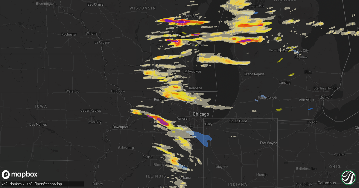
Hail Map on September 7, 2021
Get this storm
September 7 map
$229
one time, instant access
Download today. No call, no setup
Keep the $229
Bought the map and want the full workflow? Apply the entire $229 to a subscription within 7 days. None of it is wasted.
Every map, not just this one
This buys you this map. Subscription and you get every map we run, in the markets you choose from a few cities to whole states to nationwide. Plus real-time alerts the moment a storm fires.
Contact data
Name, contact info, occupancy, even credit band for addresses in the footprint. You go from where it hit to who to call.
Become the source they trust
Unlimited branding weather history reports on demand. You already have the documented answer ready for the property owner, and you are the one who showed up with it.
Property data and RoofTrace estimates
Pull up any address you have got, its value and the exact code rules for that jurisdiction, straight from One Click Code. Then RoofTrace estimates the squares, pitch, and roof value, priced the way you price.
States Impacted by Hail Map on September 7, 2021
Storm reports
Indiana
| Date | Description |
|---|---|
| 09/07/20214:48 PM CDT | Spotter measured wind gust of 68.2 mph at intersection of sr 49 and county road 255n. |
| 09/06/202110:58 PM CDT | At 356 PM CDT, severe thunderstorms were located along a line extending from St. John to near Lowell to Hopkins Park, moving east at 50 mph. HAZARD...70 mph wind gusts and quarter size hail. SOURCE...Trained weather spotters large tree limbs down in Peotone, Illinois around 345 PM CDT. IMPACT...Hail damage to vehicles is expected. Expect considerable tree damage. Wind damage is also likely to mobile homes, roofs, and outbuildings. Locations impacted include... Rensselaer, DeMotte, Hebron, Wheatfield, Lakes of the Four Seasons, Roselawn, Kouts, Hanging Grove, Boone Grove, Baileys Corner, Stoutsburg, Fair Oaks, Parr, Dunns Bridge and Malden.Including the following interstate... Indiana I-65 between mile markers 216 and 232. |
| 09/06/202110:28 PM CDT | At 328 PM CDT, severe thunderstorms were located along a line extending from near Frankfort to near Manteno to near Limestone, moving east at 50 mph. HAZARD...70 mph wind gusts and quarter size hail. SOURCE...Radar indicated. IMPACT...Hail damage to vehicles is expected. Expect considerable tree damage. Wind damage is also likely to mobile homes, roofs, and outbuildings. Locations impacted include... Gary, Merrillville, Chicago Heights, Schererville, Hobart, Kankakee, Crown Point, Highland, Munster, Park Forest, Matteson, Bourbonnais, Frankfort, Bradley, Cedar Lake, Steger, Lowell, Manteno, Peotone and Momence.Including the following interstates... I-57 between mile markers 302 and 341. Indiana I-65 between mile markers 233 and 258. |
Minnesota
| Date | Description |
|---|---|
| 09/07/20217:07 AM CDT | At 1207 AM CDT, a severe thunderstorm was located near Two Inlets, or 32 miles northeast of Detroit Lakes, moving east at 60 mph. HAZARD...Half dollar size hail. SOURCE...Radar indicated. IMPACT...Damage to vehicles is expected. This severe thunderstorm will be near... Park Rapids and Emmaville around 1215 AM CDT. Dorset around 1220 AM CDT. Nevis around 1225 AM CDT.Other locations in the path of this severe thunderstorm includeChamberlain, Badoura and Akeley. |
Florida
| Date | Description |
|---|---|
| 09/07/202112:43 AM CDT | At 543 PM EDT, a severe thunderstorm was located near Canaveral Groves, or near Lone Cabbage Fish Camp, moving south at 15 mph. HAZARD...60 mph wind gusts and quarter size hail. SOURCE...Radar indicated. IMPACT...Hail damage to vehicles is expected. Expect wind damage to roofs, siding, and trees. Locations impacted include... Titusville, Cocoa, Lone Cabbage Fish Camp, Port Saint John and Space Coast Airport. |
| 09/06/202110:29 PM CDT | At 329 PM EDT, a severe thunderstorm was located 7 miles west of Saint Augustine, moving northeast at 10 mph. HAZARD...60 mph wind gusts and penny size hail. SOURCE...Radar indicated. IMPACT...Expect damage to roofs, siding, and trees. Locations impacted include... Saint Augustine, Saint Augustine Beach, South Ponte Vedra, Vilano Beach, Saint Augustine South, Guana River State Park, Saint Augustine Shores, Anastasia, Bakersville and Elkton. |
Texas
| Date | Description |
|---|---|
| 09/07/20215:13 AM CDT | At 1012 PM CDT, a severe thunderstorm was located 6 miles southwest of Lutie, or 9 miles northwest of Wellington, moving south at 20 mph. HAZARD...60 mph wind gusts and quarter size hail. SOURCE...Radar indicated. IMPACT...Minor damage to roofs, siding, and trees is possible. Hail damage to vehicles is expected. Locations impacted include... Wellington, Quail and Lutie. |
| 09/07/20212:05 AM CDT | At 703 PM CDT, a severe thunderstorm was located 9 miles northeast of Viboras, and is nearly stationary. HAZARD...Quarter size hail and winds in excess of 40 mph. SOURCE...Radar indicated. IMPACT...Damage to vehicles is expected. This severe thunderstorm will remain over mainly rural areas of south central Jim Hogg and north central Starr Counties. |
| 09/07/20211:04 AM CDT | At 604 PM CDT, a severe thunderstorm was located over Canadian, moving south at 20 mph. HAZARD...60 mph wind gusts and quarter size hail. SOURCE...Radar indicated. IMPACT...Minor damage to roofs, siding, and trees is possible. Hail damage to vehicles is expected. Locations impacted include... Canadian. |
| 09/06/202111:05 PM CDT | At 405 PM MDT, a severe thunderstorm was located over Vado, moving southwest at 10 mph. HAZARD...60 mph wind gusts and quarter size hail. SOURCE...Radar indicated. IMPACT...Hail damage to vehicles is expected. Expect wind damage to roofs, siding, and trees. Locations impacted include... Vado, Anthony, Berino, Chamberino, San Miguel, Mesquite, La Union, La Mesa and High Valley.This includes Interstate 10 in New Mexico between mile markers 150and 161. |
Oklahoma
| Date | Description |
|---|---|
| 09/07/20216:58 PM CDT | Damage to barn and power lines down. |
| 09/07/20216:55 PM CDT | A local report indicates 61 MPH wind near 1 W FAIRVIEW |
| 09/07/20214:19 AM CDT | At 919 PM CDT, a severe thunderstorm was located 4 miles northeast of Erick, moving south at 20 mph. HAZARD...60 mph wind gusts and quarter size hail. SOURCE...Radar indicated. IMPACT...Hail damage to vehicles is expected. Expect wind damage to roofs, siding, and trees. Locations impacted include... Erick and Delhi. |
| 09/07/20213:27 AM CDT | At 826 PM CDT, a severe thunderstorm was located near Thomas, moving south at 25 mph. HAZARD...60 mph wind gusts and quarter size hail. SOURCE...Radar indicated. IMPACT...Hail damage to vehicles is expected. Expect wind damage to roofs, siding, and trees. Locations impacted include... Weatherford, Thomas, Custer City and Fay. |
| 09/07/20213:02 AM CDT | At 802 PM CDT, a severe thunderstorm was located 4 miles north of Perry, moving south at 20 mph. HAZARD...60 mph wind gusts and quarter size hail. SOURCE...Radar indicated. IMPACT...Hail damage to vehicles is expected. Expect wind damage to roofs, siding, and trees. Locations impacted include... Stillwater, Perry, Orlando, Lake Carl Blackwell and Lake Mcmurtry. |
| 09/07/20212:51 AM CDT | At 751 PM CDT, severe thunderstorms were located along a line extending from 10 miles west of Hennessey to near Hitchcock to 3 miles north of Oakwood to 5 miles south of Taloga, moving south at 20 mph. HAZARD...Golf ball size hail and 70 mph wind gusts. SOURCE...Radar indicated. IMPACT...People and animals outdoors will be injured. Expect hail damage to roofs, siding, windows, and vehicles. Expect considerable tree damage. Wind damage is also likely to mobile homes, roofs, and outbuildings. Locations impacted include... Watonga, Kingfisher, Taloga, Okeene, Thomas, Canton, Dover, Custer City, Hitchcock, Greenfield, Loyal, Oakwood, Putnam, Eagle City, Fay, southeastern Canton Lake, Hucmac, Southard, Omega and Lacey. |
| 09/07/20212:21 AM CDT | At 721 PM CDT, severe thunderstorms were located along a line extending from 4 miles southeast of Isabella to near Longdale to 4 miles southwest of Seiling, moving south at 20 mph. HAZARD...70 mph wind gusts and ping pong ball size hail. SOURCE...Radar indicated. IMPACT...People and animals outdoors will be injured. Expect hail damage to roofs, siding, windows, and vehicles. Expect considerable tree damage. Wind damage is also likely to mobile homes, roofs, and outbuildings. Locations impacted include... Watonga, Fairview, Taloga, Okeene, Seiling, Canton, Longdale, Ames, Hitchcock, Oakwood, Putnam, Canton Lake, Orion, Eagle City, Isabella, Homestead, Hucmac and Southard. |
| 09/07/20211:50 AM CDT | At 650 PM CDT, severe thunderstorms were located along a line extending from 5 miles west of Ringwood to near Fairview to 7 miles east of Orion, moving south at 15 mph. HAZARD...Ping pong ball size hail and 60 mph wind gusts. SOURCE...Radar indicated. IMPACT...People and animals outdoors will be injured. Expect hail damage to roofs, siding, windows, and vehicles. Expect wind damage to roofs, siding, and trees. Locations impacted include... Fairview, Ringwood, Cleo Springs, Longdale, Ames, Canton Lake, Orienta, Isabella and Homestead. |
| 09/07/20211:41 AM CDT | At 641 PM CDT, a severe thunderstorm was located 5 miles southeast of Tonkawa, moving southeast at 15 mph. HAZARD...60 mph wind gusts and quarter size hail. SOURCE...Radar indicated. IMPACT...Hail damage to vehicles is expected. Expect wind damage to roofs, siding, and trees. Locations impacted include... Red Rock, Marland and Sooner Lake. |
| 09/07/20211:18 AM CDT | At 618 PM CDT, a severe thunderstorm was located near Orienta, moving southeast at 15 mph. HAZARD...60 mph wind gusts and quarter size hail. SOURCE...Radar indicated. IMPACT...Hail damage to vehicles is expected. Expect wind damage to roofs, siding, and trees. Locations impacted include... Fairview, Cleo Springs and Orienta. |
| 09/06/20217:55 PM CDT | A local report indicates 1.00 inch wind near 4 NW OAKWOOD |
| 09/06/20217:30 PM CDT | A local report indicates 70 MPH wind near LONGDALE |
Illinois
| Date | Description |
|---|---|
| 09/07/20216:03 PM CDT | A couple power lines down between rantoul and gifford. Time estimated by radar. |
| 09/07/20216:01 PM CDT | Time estimated from radar. |
| 09/07/20215:58 PM CDT | Reports of trees down on power lines and power lines down on roadways. |
| 09/07/20215:35 PM CDT | Widespread tree and power line damage... Hospital roof damaged... And baseball dugout destroyed in gibson city. |
| 09/07/20215:25 PM CDT | Spotter reports multiple 3 to 4 inch branches down. |
| 09/07/20215:15 PM CDT | A local report indicates 1.75 inch wind near COLFAX |
| 09/07/20215:05 PM CDT | Several large tree limbs down on power lines. Delayed report. Time estimated by radar. |
| 09/07/20215:05 PM CDT | Large healthy tree about 2 ft diamter down near fifer st and hyatt st. Time estimated by radar. |
| 09/07/20214:20 PM CDT | Large tree limbs downed in flanagan. Relayed by wmbd. Time estimated from radar. |
| 09/07/20214:18 PM CDT | Large metal outbuilding collapsed. Relayed by wmbd. Time estimated from radar. |
| 09/07/20214:11 PM CDT | A local report indicates 1.00 inch wind near MINONK |
| 09/07/20214:10 PM CDT | Report of a tree down on sb i-55 at us 6 and overturned semi truck on i-55 at arsenal. |
| 09/07/20213:45 PM CDT | Report of a 6 to 12 inch diameter tree branch down. |
| 09/07/20213:42 PM CDT | 8 inch diameter tree limbs downed. Time estimated from radar. |
| 09/07/20213:42 PM CDT | Time estimated from radar. |
| 09/07/20213:40 PM CDT | 10 to 12 power poles downed. |
| 09/07/20213:24 PM CDT | Picture of utility polls snapped at the base relayed via social media. Time is estimated from radar. |
| 09/07/20213:21 PM CDT | Report of estimated wind gusts of 50 to 60 mph with some tree limbs down. Tree limbs are estimated to be 2 inches in diameter. |
| 09/07/20213:18 PM CDT | Damage to buildings at a farm on the corner of w hoff rd and rowell ave. Also trees uprooted and corn flattened. Time estimated from radar. |
| 09/07/20213:15 PM CDT | Spotter reports tree branches down. Winds were estimated to be 60 mph. |
| 09/07/20213:10 PM CDT | An nws storm damage survey team found widespread tree damage... Including numerous downed... Across much of and near channahon. Some of these trees were downed on struc |
| 09/07/20213:10 PM CDT | Channahon village official reports widespread damage to trees and powerlines. Estimate of 100 or more trees damaged across the village with some trees uprooted. A dozen |
| 09/07/20213:10 PM CDT | Corrects time of previous report from 2 ene channahon. Report of a tree down on sb i-55 at us 6 and overturned semi truck on i-55 at arsenal. |
| 09/07/20213:08 PM CDT | Several large tree limbs snapped in channahon. Time estimated from radar. |
| 09/07/20213:07 PM CDT | Report via social media of tractor trailers overturned at a cold storage facility. Time is estimated from radar. |
| 09/07/20213:02 PM CDT | An nws storm damage survey team found widespread tree damage... Including numerous downed... Across much of and near minooka. Some of these trees were downed on structu |
| 09/07/20213:02 PM CDT | Pictures of tree branches downed on a house via social media. Time estimated by radar. |
| 09/07/20212:59 PM CDT | Report of tree branches and limbs downed by winds estimated to be 60 to 65 mph. |
| 09/07/20212:55 PM CDT | A local report indicates 72 MPH wind near 3 E LISBON |
| 09/07/20212:55 PM CDT | Report of 16 inch diameter tree snapped. Time estimated by radar. Location is approximate. |
| 09/07/20212:55 PM CDT | Wind gust of 61 mph |
| 09/07/20212:54 PM CDT | Numerous trees downed and one snapped in half along us route 6 between morris and seneca. Power pole also damaged. Time estimated from radar. |
| 09/07/20212:52 PM CDT | Report via nws chat from spotter of 3 inch diameter tree branch down near leland... Il. |
| 09/07/20212:25 PM CDT | Multiple reports of hail up to 2 inches in diameter in and near earlville. Time estimated from radar. |
| 09/07/20212:18 PM CDT | Time estimated from radar. |
| 09/07/20212:12 PM CDT | A local report indicates 2.00 inch wind near PAW PAW |
| 09/07/20212:05 PM CDT | 20 inch diameter tree downed onto road. |
| 09/07/20212:03 PM CDT | Hail damage to siding at farmstead. Time estimated by radar. |
| 09/07/20212:01 PM CDT | Updates previous hail report from compton. Hail was at a minimum 2 inches in diameter. At least six auto windshields smashed. One residence had multiple skylights smash |
| 09/07/20211:59 PM CDT | Picture of a tree down near highland park relayed via social media. |
| 09/07/20211:58 PM CDT | Time estimated from radar. Image was sent in via social media. |
| 09/07/20211:58 PM CDT | Photo received of hail. Also reported small dents on vehicles from the hail in town. |
| 09/07/20211:55 PM CDT | Video shared on social media shows part of a large tree getting snapped off at its top. Time estimated from radar. |
| 09/07/20211:54 PM CDT | Picture of large tree down and blocking darrel rd south of il-176 relayed via social media. |
| 09/07/20211:52 PM CDT | Pwk asos peak gust. |
| 09/07/20211:48 PM CDT | A local report indicates 1.00 inch wind near 3 NNW PAW PAW |
| 09/07/20211:45 PM CDT | 14 inch diameter tree snapped at base. Time estimated by radar. |
| 09/07/20211:42 PM CDT | Report relayed via nws chat of branches down... Unknown size. Time estimated by radar. |
| 09/07/20211:36 PM CDT | Multiple large branches and trees down along roberts rd. Time estimated from radar. |
| 09/07/20211:35 PM CDT | Report relayed by wtvo/wqrf. Time and location estimated from radar. |
| 09/07/20211:30 PM CDT | Numerous tree branches downed and snapped... Large branch blocking westbound lane of il-176. Time estimated from radar. |
| 09/07/20211:30 PM CDT | Time estimated from radar. |
| 09/07/20211:29 PM CDT | Measured on personal weather station. |
| 09/07/20211:29 PM CDT | Time estimated by radar. Location approximated by wfo bgm... Caller only gave zip code. |
| 09/07/20211:27 PM CDT | A local report indicates 1.50 inch wind near WOODSTOCK |
| 09/07/20211:23 PM CDT | Quarter size hail report from mping. Time estimated from radar. |
| 09/07/20211:20 PM CDT | Time estimated from radar. |
| 09/07/20211:20 PM CDT | A local report indicates 1.00 inch wind near SPRING GROVE |
| 09/07/20211:16 PM CDT | A local report indicates 1.00 inch wind near 2 E RICHMOND |
| 09/07/20211:13 PM CDT | Quarter size hail report from mping. Time estimated from radar. |
| 09/07/20211:13 PM CDT | Small tree about 6 inches in diameter snapped. Time estimated from radar. |
| 09/07/202112:59 PM CDT | Time estimated by radar. |
| 09/07/202112:55 PM CDT | Time estimated from radar. |
| 09/07/202112:44 PM CDT | Delayed report. Hail ranged from pea to 1 inch with some golfball sized. Occurred 1244-47 pm. |
| 09/07/202112:43 PM CDT | A local report indicates 1.00 inch wind near 2 W USTICK |
| 09/07/202112:41 PM CDT | Delayed report. Golfball hail for 4 minutes 1241-45 pm. |
| 09/07/202112:32 PM CDT | Picture of tree down sent via social media. Time is estimated from radar. |
| 09/07/20217:47 AM CDT | At 1246 PM CDT, a severe thunderstorm was located near Fairhaven, or near Morrison, moving east at 45 mph. HAZARD...60 mph wind gusts and quarter size hail. SOURCE...Radar indicated. IMPACT...Hail damage to vehicles is expected. Expect wind damage to roofs, siding, and trees. This severe thunderstorm will be near... Coleta around 100 PM CDT. |
| 09/07/20217:30 AM CDT | At 1229 PM CDT, severe thunderstorms were located along a line extending from near Elkhorn to near South Beloit, moving east at 60 mph. HAZARD...Quarter size hail. SOURCE...Radar indicated. IMPACT...Damage to vehicles is expected. Locations impacted include... Kenosha, Racine, Beloit, Mount Pleasant, Pleasant Prairie, Elkhorn, Delavan, Lake Geneva, Sturtevant, Union Grove, Paddock Lake, Williams Bay, Camp Lake, Winthrop Harbor, Wheatland, Genoa City, Walworth, Silver Lake, Clinton and Fontana-On-Geneva Lake. |
| 09/07/20212:04 AM CDT | At 704 PM CDT, a severe thunderstorm was located over Ashkum, or near Clifton, moving southeast at 35 mph. HAZARD...60 mph wind gusts and quarter size hail. SOURCE...Radar indicated. IMPACT...Hail damage to vehicles is expected. Expect wind damage to roofs, siding, and trees. Locations impacted include... Watseka, Gilman, Clifton, Sheldon, Ashkum, Martinton, Crescent City, Danforth, Woodland, Donovan and Iroquois.Including the following interstate... I-57 between mile markers 282 and 299. |
| 09/07/20211:09 AM CDT | At 608 PM CDT, severe thunderstorms were located along a line extending from near Rankin to 6 miles north of St. Joseph to Mahomet, moving southeast at 45 mph. HAZARD...60 mph wind gusts and nickel size hail. SOURCE...Radar indicated. IMPACT...Expect damage to roofs, siding, and trees. Severe thunderstorms will be near... Rankin around 615 PM CDT. Ogden and Potomac around 620 PM CDT. Savoy, Tolono, Rossville, Fithian and Muncie around 625 PM CDT.Other locations in the path of these severe thunderstorms includeOakwood, Fairmount, St. Joseph, Catlin, Philo, Danville, Westville,Tilton, Sidney, Belgium, Georgetown, Homer, Broadlands and Allerton.This includes the following highways... Interstate 57 between mile markers 218 and 251. Interstate 72 between mile markers 174 and 182. Interstate 74 between mile marker 169 and the Indiana border. |
| 09/07/202112:46 AM CDT | At 546 PM CDT, a severe thunderstorm was located over Mazon, or 7 miles southwest of Coal City, moving southeast at 35 mph. HAZARD...60 mph wind gusts and half dollar size hail. SOURCE...Radar indicated. IMPACT...Hail damage to vehicles is expected. Expect wind damage to roofs, siding, and trees. Locations impacted include... Kankakee, Bourbonnais, Bradley, Manteno, Braidwood, Wilmington, Coal City, Dwight, Herscher, Diamond, Limestone, Gardner, Lakewood Shores, Mazon, Braceville, Essex, South Wilmington, Godley, Bonfield and Carbon Hill.Including the following interstates... I-55 between mile markers 213 and 238. I-57 between mile markers 314 and 321.This includes... Kankakee River State Park and Olivet NazarineUniversity. |
| 09/07/202112:39 AM CDT | At 538 PM CDT, severe thunderstorms were located along a line extending from near Gibson City to near Downs, moving east at 40 mph. HAZARD...60 mph wind gusts and quarter size hail. SOURCE...Radar indicated. IMPACT...Hail damage to vehicles is expected. Expect wind damage to roofs, siding, and trees. Severe thunderstorms will be near... Rantoul around 555 PM CDT.Other locations in the path of these severe thunderstorms includeFarmer City, Saybrook, Gifford, Mansfield and Fisher.This includes the following highways... Interstate 57 between mile markers 245 and 257. Interstate 74 between mile markers 142 and 166. |
| 09/06/202111:59 PM CDT | At 458 PM CDT, severe thunderstorms were located along a line extending from near Cullom to near Lexington, moving southeast at 35 mph. HAZARD...60 mph wind gusts and quarter size hail. SOURCE...Radar indicated. IMPACT...Hail damage to vehicles is expected. Expect wind damage to roofs, siding, and trees. Locations impacted include... Paxton, Fairbury, Gibson City, Gilman, Chatsworth, Onarga, Forrest, Cissna Park, Piper City, Buckley, Melvin, Loda, Roberts, Elliott, Sibley, Thawville, Clarence, Strawn and Claytonville.Including the following interstate... I-57 between mile markers 258 and 283. |
| 09/06/202111:58 PM CDT | At 457 PM CDT, severe thunderstorms were located along a line extending from near Fairbury to near Lexington, moving southeast at 40 mph. HAZARD...60 mph wind gusts and quarter size hail. SOURCE...Radar indicated. IMPACT...Hail damage to vehicles is expected. Expect wind damage to roofs, siding, and trees. Severe thunderstorms will be near... Colfax around 515 PM CDT.Other locations in the path of these severe thunderstorms includeSaybrook, Cooksville, and Arrowsmith.This includes Interstate 55 between mile markers 173 and 182. |
| 09/06/202111:22 PM CDT | At 421 PM CDT, a severe thunderstorm was located near El Paso, or 16 miles northeast of Eureka, moving southeast at 40 mph. HAZARD...60 mph wind gusts and quarter size hail. SOURCE...Radar indicated. At 411 PM, quarter size hail was reported at Minonk. IMPACT...Hail damage to vehicles is expected. Expect wind damage to roofs, siding, and trees. This severe thunderstorm will be near... Gridley around 435 PM CDT.Other locations in the path of this severe thunderstorm includeLexington, Chenoa and Colfax.This includes the following highways... Interstate 39 between mile markers 16 and 23. Interstate 55 between mile markers 178 and 186. |
| 09/06/202111:06 PM CDT | At 406 PM CDT, severe thunderstorms were located along a line extending from 6 miles west of Herscher to near Minonk, moving southeast at 35 mph. HAZARD...60 mph wind gusts and quarter size hail. SOURCE...Radar indicated. IMPACT...Hail damage to vehicles is expected. Expect wind damage to roofs, siding, and trees. Locations impacted include... Pontiac, Dwight, Fairbury, Herscher, Clifton, Gridley, Forrest, Flanagan, Odell, Ashkum, Cullom, Cornell, Saunemin, Danforth, Rutland, Buckingham, Cabery, Kempton, Long Point and Campus.Including the following interstates... I-55 between mile markers 188 and 217. I-57 between mile markers 289 and 300. |
| 09/06/202110:53 PM CDT | At 353 PM CDT, severe thunderstorms were located along a line extending from near Wenona to near Washburn, moving east at 60 mph. HAZARD...60 mph wind gusts and quarter size hail. SOURCE...Radar indicated. IMPACT...Hail damage to vehicles is expected. Expect wind damage to roofs, siding, and trees. Severe thunderstorms will be near... Toluca around 405 PM CDT. Minonk around 410 PM CDT.This includes Interstate 39 between mile markers 21 and 38. |
| 09/06/20219:57 PM CDT | At 254 PM CDT, severe thunderstorms were located along a line extending from 8 miles northwest of Minooka to near Morris to Seneca, moving east at 55 mph. HAZARD...70 mph wind gusts and ping pong ball size hail. SOURCE...Trained weather spotters reported 2 inch diameter hail near Earlville. IMPACT...People and animals outdoors will be injured. Expect hail damage to roofs, siding, windows, and vehicles. Expect considerable tree damage. Wind damage is also likely to mobile homes, roofs, and outbuildings. Locations impacted include... Joliet, Orland Park, Tinley Park, Plainfield, Kankakee, Lockport, New Lenox, Homer Glen, Park Forest, Mokena, Bourbonnais, Frankfort, Bradley, Morris, Channahon, Minooka, Manteno, Braidwood, Wilmington and Coal City.Including the following interstates... I-55 between mile markers 226 and 256. I-57 near mile marker 307, and between mile markers 311 and 338. I-80 between mile markers 96 and 149. |
| 09/06/20219:29 PM CDT | At 228 PM CDT, severe thunderstorms were located along a line extending from Leland to Earlville, moving southeast at 35 mph. THESE ARE DESTRUCTIVE STORMS FOR Earlville, Leland, Serena, Newark, and Sheridan. HAZARD...Baseball size hail and 70 mph wind gusts. SOURCE...Radar indicated. IMPACT...People and animals outdoors will be severely injured. Expect shattered windows, extensive damage to roofs, siding, and vehicles. Locations impacted include... Sheridan, Lake Holiday, Somonauk, Earlville, Serena, Newark, Leland, Millington, Millbrook, Lisbon, Plattville, Harding and Norway. |
| 09/06/20219:15 PM CDT | At 215 PM CDT, a severe thunderstorm was located over Vernon Hills, moving east at 50 mph. HAZARD...Ping pong ball size hail and 60 mph wind gusts. SOURCE...Radar indicated. IMPACT...People and animals outdoors will be injured. Expect hail damage to roofs, siding, windows, and vehicles. Expect wind damage to roofs, siding, and trees. Locations impacted include... Waukegan, Arlington Heights, Palatine, Buffalo Grove, Wheeling, Northbrook, North Chicago, Mundelein, Highland Park, Vernon Hills, Grayslake, Libertyville, Lake Zurich, Lake Forest, Wauconda, Barrington, Deerfield, Glencoe, Long Grove and Hawthorn Woods.Including the following interstates... I-94 between mile markers 13 and 26. I-294 between mile markers 13 and 26.This includes... Great Lakes Naval Training Center, Lake County ILFairgrounds, Lake Forest College, and Ravinia Music Festival. |
| 09/06/20219:03 PM CDT | At 203 PM CDT, severe thunderstorms were located along a line extending from near Shabbona to near Sublette, moving southeast at 35 mph. HAZARD...Golf ball size hail and 60 mph wind gusts. SOURCE...Trained weather spotters. IMPACT...People and animals outdoors will be injured. Expect hail damage to roofs, siding, windows, and vehicles. Expect wind damage to roofs, siding, and trees. Locations impacted include... Aurora, Joliet, Plainfield, Oswego, Ottawa, Yorkville, Morris, Channahon, Minooka, Plano, Sandwich, Mendota, Sheridan, Montgomery, Boulder Hill, Lake Holiday, Somonauk, Earlville, Serena and Newark.Including the following interstates... I-39 between mile markers 67 and 77. I-80 between mile markers 91 and 122.This includes... Gebhard Woods State Park, Grundy County Speedwayand Fairgrounds, Tri-County Fairgrounds, and William G Stratton StatePark. |
| 09/06/20218:41 PM CDT | At 141 PM CDT, a severe thunderstorm was located over Lake Zurich, moving east at 55 mph. HAZARD...70 mph wind gusts and half dollar size hail. SOURCE...At 132 PM CDT trained weather spotters reported a 68 mph gust near Crystal Lake. IMPACT...Hail damage to vehicles is expected. Expect considerable tree damage. Wind damage is also likely to mobile homes, roofs, and outbuildings. Locations impacted include... Chicago, Arlington Heights, Evanston, Schaumburg, Palatine, Skokie, Des Plaines, Mount Prospect, Hoffman Estates, Glenview, Buffalo Grove, Wheeling, Park Ridge, Northbrook, Elk Grove Village, Niles, Lake View, Irving Park, West Ridge and Lincoln Park.Including the following interstates... I-90 between mile markers 64 and 84. I-94 between mile markers 26 and 45. I-294 between mile markers 26 and 45.This includes... Lincoln Park Zoo, Loyola University, OaktonCommunity College, Harper College, Northeastern Illinois University,Northwestern University, and Wrigley Field. |
| 09/06/20218:35 PM CDT | A local report indicates 64 MPH wind near COLES COUNTY AIRPORT |
| 09/06/20218:23 PM CDT | At 122 PM CDT, severe thunderstorms were located along a line extending from near Ashton to near Dixon, moving east at 45 mph. HAZARD...60 mph wind gusts and half dollar size hail. SOURCE...Radar indicated. IMPACT...Hail damage to vehicles is expected. Expect wind damage to roofs, siding, and trees. Locations impacted include... DeKalb, Sycamore, Dixon, Campton Hills, Rochelle, Sandwich, Amboy, Shabbona, Elburn, Cortland, Hinckley, Somonauk, Waterman, Hillcrest, Maple Park, Malta, Franklin Grove, Lily Lake, Ashton and Paw Paw.Including the following interstates... I-39 between mile markers 78 and 102. I-88 between mile markers 47 and 106.This includes... Northern Illinois University, Sandwich Fairgrounds,and Lee County Fairgrounds. |
New Mexico
| Date | Description |
|---|---|
| 09/07/20212:10 AM CDT | At 710 PM MDT, severe thunderstorms were located along a line extending from near Alamo Hueco to 9 miles east of Antelope Wells, moving southwest at 35 mph. HAZARD...60 mph wind gusts and quarter size hail. SOURCE...Radar indicated. IMPACT...Hail damage to vehicles is expected. Expect wind damage to roofs, siding, and trees. Locations impacted include... Antelope Wells, Alamo Hueco and Playas Valley. |
| 09/07/20211:22 AM CDT | At 622 PM MDT, a severe thunderstorm was located near Deming, moving west at 30 mph. HAZARD...60 mph wind gusts and quarter size hail. SOURCE...Radar indicated. IMPACT...Hail damage to vehicles is expected. Expect wind damage to roofs, siding, and trees. Locations impacted include... Deming, Gage, Sunshine and Spring Canyon State Park. This includes Interstate 10 in New Mexico between mile markers 62 and84. |
| 09/07/202112:48 AM CDT | At 548 PM MDT, a severe thunderstorm was located 5 miles northwest of Akela, moving west at 40 mph. HAZARD...Golf ball size hail and 60 mph wind gusts. SOURCE...Radar indicated. IMPACT...People and animals outdoors will be injured. Expect hail damage to roofs, siding, windows, and vehicles. Expect wind damage to roofs, siding, and trees. Locations impacted include... Deming, Akela, Sunshine, Rock Hound State Park and Spring Canyon State Park.This includes Interstate 10 in New Mexico between mile markers 66 and105. |
| 09/06/20219:57 PM CDT | At 256 PM MDT, a severe thunderstorm was located 15 miles northeast of Orogrande, and is nearly stationary. HAZARD...60 mph wind gusts and half dollar size hail. SOURCE...Radar indicated. IMPACT...Hail damage to vehicles is expected. Expect wind damage to roofs, siding, and trees. This severe thunderstorm will remain over mainly rural areas of west central Otero County.This includes Highway 54 in New Mexico between mile markers 36 and47. |
Wisconsin
| Date | Description |
|---|---|
| 09/07/20215:50 PM CDT | Sporadic tree and power line damage this location and near lake nabagamon. Time estimated off radar... But happened between 545 and 6 pm. |
| 09/07/202112:48 PM CDT | A local report indicates 1.00 inch wind near 1 NNW WALWORTH |
| 09/07/202112:46 PM CDT | A local report indicates 1.00 inch wind near 1 S COMO |
| 09/07/202112:44 PM CDT | Penny size to ping pong ball size. Time estimated from radar. |
| 09/07/202112:44 PM CDT | A local report indicates 1.00 inch wind near 1 NNE COMO |
| 09/07/202112:42 PM CDT | A local report indicates 1.00 inch wind near ELKHORN |
| 09/07/202112:35 PM CDT | A local report indicates 1.00 inch wind near 4 WSW CLINTON |
| 09/07/202112:33 PM CDT | Multiple reports of 1.0 to 1.5 inch hail reported around delavan wi. |
| 09/07/202112:32 PM CDT | Corrects previous hail report from delavan. 1.0 to 1.25 inch hail reported by trained spotter. |
| 09/07/202111:52 AM CDT | Report from mping: quarter |
| 09/07/202111:35 AM CDT | A local report indicates 1.00 inch wind near EDGERTON |
| 09/07/202111:24 AM CDT | A local report indicates 1.00 inch wind near 2 WSW WATERTOWN |
| 09/07/202111:22 AM CDT | Spotter reported quarter size hail in stoughton. |
| 09/07/202111:22 AM CDT | Sheriffs office reported quarter size hail in allenton. |
| 09/07/202111:12 AM CDT | A local report indicates 1.00 inch wind near 2 N KOHLER |
| 09/07/202111:10 AM CDT | A local report indicates 1.00 inch wind near FITCHBURG |
| 09/07/202111:08 AM CDT | Time estimated from radar. |
| 09/07/202111:07 AM CDT | Nickel to quarter size hail. |
| 09/07/202110:59 AM CDT | A local report indicates 1.00 inch wind near 2 W VERONA |
| 09/07/202110:58 AM CDT | A local report indicates 1.50 inch wind near 2 W VERONA |
| 09/07/202110:57 AM CDT | A local report indicates 1.00 inch wind near 1 NNE VERONA |
| 09/07/202110:55 AM CDT | A local report indicates 1.00 inch wind near 1 ESE MIDDLETON |
| 09/07/202110:51 AM CDT | A local report indicates 1.00 inch wind near 4 NNE CROSS PLAINS |
| 09/07/202110:48 AM CDT | Report received via social media. |
| 09/07/202110:45 AM CDT | A local report indicates 1.75 inch wind near FOND DU LAC |
| 09/07/202110:45 AM CDT | A local report indicates 1.00 inch wind near 1 N KEWASKUM |
| 09/07/202110:42 AM CDT | A local report indicates 1.00 inch wind near 2 SSE FOND DU LAC |
| 09/07/202110:39 AM CDT | Spotter reported ping pong ball size hail near the intersection of. |
| 09/07/202110:38 AM CDT | Time estimated from radar. |
| 09/07/202110:30 AM CDT | Report of quarter size hail from mazomanie. Time estimated from radar. |
| 09/07/202110:25 AM CDT | A local report indicates 1.00 inch wind near 8 ESE VALDERS |
| 09/07/202110:24 AM CDT | Penny to quarter size hail. |
| 09/07/202110:15 AM CDT | Report from mping. |
| 09/07/202110:10 AM CDT | Image shared with us on social media. |
| 09/07/202110:04 AM CDT | Reported at chilton high school. |
| 09/07/20219:49 AM CDT | Report from mping. |
| 09/07/20219:46 AM CDT | Report from fox valley lutheran high school. |
| 09/07/20219:43 AM CDT | Reports of 3/4 inch up to 2 inch hail. |
| 09/07/20219:39 AM CDT | At eaa. |
| 09/07/20219:37 AM CDT | Report from mping. |
| 09/07/20219:32 AM CDT | Highway nn and highway z. |
| 09/07/20219:27 AM CDT | The hail caused damage to cars. |
| 09/07/20219:27 AM CDT | A local report indicates 4.00 inch wind near 3 NNE KIMBERLY |
| 09/07/20219:20 AM CDT | Just north of berlin. |
| 09/07/20219:18 AM CDT | A local report indicates 1.00 inch wind near KAUKAUNA |
| 09/07/20219:18 AM CDT | A local report indicates 1.00 inch wind near BERLIN |
| 09/07/20219:18 AM CDT | Near hwy 55 / ce. |
| 09/07/20219:13 AM CDT | Corrects the time of the previous hail report from 3 nne kimberly. |
| 09/07/20219:12 AM CDT | A local report indicates 1.50 inch wind near 2 N APPLETON |
| 09/07/20219:12 AM CDT | A local report indicates 1.50 inch wind near APPLETON |
| 09/07/20219:10 AM CDT | Northeast side of appleton at jj and french road. |
| 09/07/20219:10 AM CDT | Occurred at northland avenue and meade street. |
| 09/07/20219:10 AM CDT | Northeast side of appleton at jj and french road. |
| 09/07/20219:06 AM CDT | Located approximately 1 mile east of meade street and northland avenue. Time of report estimated. |
| 09/07/20219:06 AM CDT | Located approximately 1 mile east of meade street and northland avenue. Time of report estimated. |
| 09/07/20219:04 AM CDT | A local report indicates 1.50 inch wind near 1 N GREENLEAF |
| 09/07/20219:02 AM CDT | A local report indicates 1.50 inch wind near 1 SE LITTLE RAPIDS |
| 09/07/20218:59 AM CDT | A local report indicates 2.50 inch wind near WRIGHTSTOWN |
| 09/07/20218:57 AM CDT | A local report indicates 2.00 inch wind near WRIGHTSTOWN |
| 09/07/20218:55 AM CDT | A local report indicates 2.75 inch wind near FREEDOM |
| 09/07/20218:53 AM CDT | Hailed for 2 minutes. Highway t and tt. |
| 09/07/20218:53 AM CDT | Hailed for 2 minutes. Highway t and tt. |
| 09/07/20218:50 AM CDT | One inch or greater hail near highway s and 47. |
| 09/07/20218:50 AM CDT | North side of appleton. |
| 09/07/20218:48 AM CDT | Broke home window. |
| 09/07/20218:47 AM CDT | Time estimated from radar. |
| 09/07/20218:47 AM CDT | North of appleton on the intersection of jj and e. |
| 09/07/20218:47 AM CDT | North of appleton on the intersection of jj and echo. A couple of baseball sized hail. Mostly golf ball sized hail. |
| 09/07/20218:47 AM CDT | A local report indicates 3.75 inch wind near 2 NNW KAUKAUNA |
| 09/07/20218:47 AM CDT | Corrects size of the previous hail report from 5 nne appleton. 4.5 inch hail measured. Report via social media. Time estimated by radar. |
| 09/07/20218:47 AM CDT | In downtown hortonville. |
| 09/07/20218:46 AM CDT | Report from fox valley lutheran high school. Time estimated by radar. |
| 09/07/20218:45 AM CDT | A local report indicates 1.75 inch wind near MACKVILLE |
| 09/07/20218:45 AM CDT | Corrects location and size of tennis ball sized hail from previous report. Hail of 4.1 inches was measured. Six miles north of the appleton airport. Hail hitting the gr |
| 09/07/20218:45 AM CDT | Tennis ball sized hail of 2.4 to 2.5 inches. Six miles north of the appleton airport. Hail hitting the ground and breaking. |
| 09/07/20218:40 AM CDT | Tennis ball sized hail of 2.4 to 2.5 inches. Six miles north of the appleton airport. Hail hitting the ground and breaking. |
| 09/07/20218:39 AM CDT | 2 miles west of highway m and s. |
| 09/07/20218:38 AM CDT | A local report indicates 1.00 inch wind near 2 NNE STEPHENSVILLE |
| 09/07/20218:25 AM CDT | A local report indicates 1.00 inch wind near 1 W NEW LONDON |
| 09/07/20217:37 AM CDT | At 1236 PM CDT, a severe thunderstorm was located near Poplar Grove, moving east at 50 mph. HAZARD...60 mph wind gusts and quarter size hail. SOURCE...Radar indicated. IMPACT...Hail damage to vehicles is expected. Expect wind damage to roofs, siding, and trees. Locations impacted include... Crystal Lake, Beloit, McHenry, Woodstock, Machesney Park, Roscoe, Fox Lake, Harvard, Island Lake, South Beloit, Rockton, Poplar Grove, Johnsburg, Lakemoor, Spring Grove, Candlewick Lake, Wonder Lake, Pistakee Highlands, Oakwood Hills and Prairie Grove.Including the following interstate... I-90 between mile markers 0 and 9. This includes... Mchenry County Fairgrounds and Moraine Hills StatePark. |
| 09/07/20217:19 AM CDT | At 1219 PM CDT, a severe thunderstorm was located near East Troy, moving east at 50 mph. HAZARD...Quarter size hail. SOURCE...Radar indicated. IMPACT...Damage to vehicles is expected. Locations impacted include... Racine, Mount Pleasant, Sturtevant, Union Grove, East Troy, Wind Lake, Rochester, Raymond, Yorkville, Wind Point, Browns Lake, Waterford North, Potter Lake, Eagle Lake, Caledonia, Burlington, Waterford, Honey Creek, Elmwood Park and North Bay. |
| 09/07/20216:45 AM CDT | At 1145 AM CDT, severe thunderstorms were located along a line extending from near Okauchee Lake to near Lake Koshkonong, moving east at 55 mph. HAZARD...Quarter size hail. SOURCE...Radar indicated. IMPACT...Damage to vehicles is expected. Severe thunderstorms will be near... Delafield and Wales around 1150 AM CDT. Waukesha and Pewaukee around 1155 AM CDT. New Berlin, Brookfield, Palmyra and Brookfield around 1200 PM CDT. Milwaukee, Wauwatosa and Elm Grove around 1205 PM CDT. West Milwaukee, Ottawa and North Prairie around 1210 PM CDT. Mukwonago and Milwaukee Hoan Bridge around 1215 PM CDT. Vernon around 1220 PM CDT. Big Bend around 1225 PM CDT.Other locations impacted by these severe thunderstorms include StateFair Park, Waterville, Marquette University, Mitchell Park Domes,Milwaukee Co Zoo, Miller Park, Genesee Depot, Genesee, MilwaukeeSouth Shore Park and Maier Festival Park. |
| 09/07/20216:42 AM CDT | At 1141 AM CDT, severe thunderstorms were located along a line extending from near Lake Koshkonong to 6 miles southwest of Edgerton, moving east at 60 mph. HAZARD...Quarter size hail. SOURCE...Radar indicated. IMPACT...Damage to vehicles is expected. Severe thunderstorms will be near... Milton and Lake Koshkonong around 1150 AM CDT. Whitewater around 1155 AM CDT. East Troy and Potter Lake around 1220 PM CDT.Other locations impacted by these severe thunderstorms includeIndianford, Abells Corners, Tibbets, Troy Center, Leyden, Millard, LaGrange, Lima Center, Richmond and Johnstown Center. |
| 09/07/20216:27 AM CDT | At 1126 AM CDT, severe thunderstorms were located along a line extending from near Hustisford to Johnson Creek, moving east at 55 mph. HAZARD...60 mph wind gusts and quarter size hail. SOURCE...Radar indicated. IMPACT...Hail damage to vehicles is expected. Expect wind damage to roofs, siding, and trees. Severe thunderstorms will be near... Hartford, Oconomowoc and Lac La Belle around 1135 AM CDT. Delafield and Okauchee Lake around 1140 AM CDT. Hartland and Merton around 1145 AM CDT. Waukesha, Pewaukee, Sussex, Jackson, Germantown and Lisbon around 1150 AM CDT. Brookfield, Cedarburg, Elm Grove, Thiensville, Butler and Brookfield around 1155 AM CDT. Wauwatosa, Mequon, Grafton and Bayside around 1200 PM CDT. Whitefish Bay and Glendale around 1205 PM CDT.Other locations impacted by these severe thunderstorms includeMarquette University, Colgate, Chenequa, Richfield, UW-Milwaukee, Mapleton, Stone Bank, Summit, North Lake and Holy Hill. |
| 09/07/20216:11 AM CDT | At 1110 AM CDT, a severe thunderstorm was located over Belleville, or 8 miles southwest of Oregon, moving east at 45 mph. HAZARD...Quarter size hail. SOURCE...Radar indicated. IMPACT...Damage to vehicles is expected. This severe thunderstorm will be near... Brooklyn around 1120 AM CDT. Evansville around 1125 AM CDT. Edgerton around 1135 AM CDT.Other locations impacted by this severe thunderstorm include Fulton,Cooksville, Indianford, Attica and Dayton. |
| 09/07/20216:04 AM CDT | At 1102 AM CDT, a severe thunderstorm was located over Horicon, moving east at 70 mph. HAZARD...Ping pong ball size hail and 60 mph wind gusts. SOURCE...Radar indicated. IMPACT...People and animals outdoors will be injured. Expect hail damage to roofs, siding, windows, and vehicles. Expect wind damage to roofs, siding, and trees. Locations impacted include... West Bend, Beaver Dam, Hartford, Grafton, Cedarburg, Waupun, Port Washington, Jackson, Mayville, Slinger, Saukville, Kewaskum, Horicon, Juneau, Lomira, Belgium, Fredonia, Cedar Grove, Campbellsport and Random Lake. |
| 09/07/20216:01 AM CDT | At 1100 AM CDT, severe thunderstorms were located along a line extending from 6 miles north of Sun Prairie to near New Glarus, moving east at 60 mph. HAZARD...Quarter size hail. SOURCE...Radar indicated. IMPACT...Damage to vehicles is expected. Severe thunderstorms will be near... Sun Prairie around 1105 AM CDT. Columbus, Marshall and Waterloo around 1110 AM CDT. Oregon and Brooklyn around 1115 AM CDT. Watertown and Stoughton around 1125 AM CDT. Edgerton around 1135 AM CDT. Lake Koshkonong around 1140 AM CDT. Whitewater around 1150 AM CDT. Palmyra around 1155 AM CDT.Other locations impacted by these severe thunderstorms includeBusseyville, Richwood, Hubbleton, Utica, Rockdale, Rome, Token Creek,Henry Vilas Zoo, Hebron and Helenville. |
| 09/07/20215:27 AM CDT | At 1026 AM CDT, severe thunderstorms were located along a line extending from near St Anna to 6 miles east of Fond Du Lac to near Oakfield, moving east at 35 mph. HAZARD...60 mph wind gusts and quarter size hail. SOURCE...Radar indicated. IMPACT...Hail damage to vehicles is expected. Expect wind damage to roofs, siding, and trees. Locations impacted include... Sheboygan, Fond Du Lac, Plymouth, Sheboygan Falls, North Fond Du Lac, Howards Grove, Oostburg, Kohler, Cedar Grove, Elkhart Lake, Southern Lake Winnebago, Taycheedah, Lamartine, Greenbush, Eden, Mount Calvary, Cascade, Adell, Waldo and St. Cloud. |
| 09/07/20215:18 AM CDT | At 1016 AM CDT, a severe thunderstorm was located near Chilton, or 18 miles northwest of Plymouth, moving east at 55 mph. At 1004 am half dollar size hail was reported near Chilton. Another severe storm was located near St Nazianz. HAZARD...Half dollar size hail. SOURCE...Public. IMPACT...Damage to vehicles is expected. This severe thunderstorm will be near... St. Nazianz and Camp Rokilio Scout Camp around 1025 AM CDT. Valders around 1030 AM CDT. Cleveland around 1035 AM CDT.Other locations in the path of this severe thunderstorm includeManitowoc. |
| 09/07/20215:10 AM CDT | At 1010 AM CDT, a severe thunderstorm was located near Rosendale, or 8 miles north of Waupun, moving east at 40 mph. HAZARD...Ping pong ball size hail and 60 mph wind gusts. SOURCE...Radar indicated. IMPACT...People and animals outdoors will be injured. Expect hail damage to roofs, siding, windows, and vehicles. Expect wind damage to roofs, siding, and trees. Locations impacted include... Fond Du Lac, Waupun, North Fond Du Lac, Oakfield, Rosendale, Brandon, Taycheedah, Lamartine, Byron, Alto, Eden, Fairwater, Oak Center, Dundee, Waucousta, Lagoda and Town of Forest. |
| 09/07/20214:34 AM CDT | At 934 AM CDT, a severe thunderstorm was located over Ripon, moving east at 50 mph. HAZARD...60 mph wind gusts and quarter size hail. SOURCE...Radar indicated. IMPACT...Hail damage to vehicles is expected. Expect wind damage to roofs, siding, and trees. Locations impacted include... Ripon, North Fond Du Lac, Rosendale, Southern Lake Winnebago, Eldorado, Mount Calvary, St. Cloud, Van Dyne, Peebles, Pipe, Calvary, Marytown, Johnsburg and West Rosendale. |
| 09/07/20214:30 AM CDT | At 929 AM CDT, a severe thunderstorm was located near Rush Lake, or 9 miles west of Oshkosh, moving east at 60 mph. Spotters reported one inch hail just north of Berlin. HAZARD...60 mph wind gusts and quarter size hail. SOURCE...Trained weather spotters. IMPACT...Hail damage to vehicles is expected. Expect wind damage to roofs, siding, and trees. This severe thunderstorm will be near... Oshkosh around 940 AM CDT.Other locations in the path of this severe thunderstorm includeCentral Lake Winnebago, Northern Lake Winnebago, Chilton, St.Nazianz, Camp Rokilio Scout Camp and Valders. |
| 09/07/20214:16 AM CDT | At 914 AM CDT, a severe thunderstorm was located over Darboy, or near Appleton, moving east at 55 mph. Ping pong ball size hail was reported in Appleton 912 am. HAZARD...Ping pong ball size hail and 60 mph wind gusts. SOURCE...Radar indicated. IMPACT...People and animals outdoors will be injured. Expect hail damage to roofs, siding, windows, and vehicles. Expect wind damage to roofs, siding, and trees. This severe thunderstorm will be near... Brillion around 930 AM CDT.Other locations in the path of this severe thunderstorm include TwoCreeks. |
| 09/07/20214:09 AM CDT | At 908 AM CDT, a severe thunderstorm was located near Denmark, or 12 miles south of Green Bay, moving east at 55 mph. Ping pong ball size hail was reported 1 mile north of Greenleaf at 904 am. HAZARD...Ping pong ball size hail and 60 mph wind gusts. SOURCE...Trained weather spotters. IMPACT...People and animals outdoors will be injured. Expect hail damage to roofs, siding, windows, and vehicles. Expect wind damage to roofs, siding, and trees. This severe thunderstorm will be near... Denmark around 915 AM CDT.Other locations in the path of this severe thunderstorm include TwoCreeks. |
| 09/07/20214:02 AM CDT | At 902 AM CDT, a severe thunderstorm was located near Redgranite, or 9 miles southeast of Wautoma, moving east at 55 mph. HAZARD...60 mph wind gusts and half dollar size hail. SOURCE...Radar indicated. IMPACT...Hail damage to vehicles is expected. Expect wind damage to roofs, siding, and trees. This severe thunderstorm will be near... Redgranite around 905 AM CDT. Rush Lake around 920 AM CDT.Other locations in the path of this severe thunderstorm includeOshkosh. |
| 09/07/20213:57 AM CDT | At 857 AM CDT, a severe thunderstorm was located 8 miles northwest of Princeton, or 9 miles south of Wautoma, moving east at 60 mph. HAZARD...Ping pong ball size hail and 60 mph wind gusts. SOURCE...Radar indicated. IMPACT...People and animals outdoors will be injured. Expect hail damage to roofs, siding, windows, and vehicles. Expect wind damage to roofs, siding, and trees. Locations impacted include... Berlin, Montello, Westfield, Princeton, Green Lake, Oxford, Neshkoro and Harrisville. |
| 09/07/20213:42 AM CDT | At 841 AM CDT, a severe thunderstorm was located 7 miles south of Black Creek, or 8 miles northwest of Appleton, moving east at 55 mph. One inch hail was observed near New London around 825 am. HAZARD...60 mph wind gusts and quarter size hail. SOURCE...Radar indicated. IMPACT...Hail damage to vehicles is expected. Expect wind damage to roofs, siding, and trees. This severe thunderstorm will be near... Appleton around 845 AM CDT. Kaukauna, Little Chute and Kimberly around 850 AM CDT.Other locations in the path of this severe thunderstorm includeBellevue Town and Denmark. |
| 09/07/20213:11 AM CDT | At 811 AM CDT, a severe thunderstorm was located near Waupaca, moving east at 55 mph. HAZARD...60 mph wind gusts and quarter size hail. SOURCE...Radar indicated. IMPACT...Hail damage to vehicles is expected. Expect wind damage to roofs, siding, and trees. This severe thunderstorm will be near... New London around 825 AM CDT.Other locations in the path of this severe thunderstorm include BlackCreek. |
| 09/06/202110:29 PM CDT | At 328 AM CDT, a severe thunderstorm was located near Stone Lake, or 8 miles south of Hayward, moving east at 60 mph. HAZARD...60 mph wind gusts and half dollar size hail. SOURCE...Radar indicated. IMPACT...Hail damage to vehicles is expected. Expect wind damage to roofs, siding, and trees. This severe thunderstorm will be near... Chief Lake on Chippewa Flowage around 335 AM CDT. Couderay around 340 AM CDT. Chippewa Flowage West, Chippewa Flowage East and New Post around 345 AM CDT.Other locations in the path of this severe thunderstorm includeWinter. |
| 09/06/20218:20 PM CDT | At 119 PM CDT, severe thunderstorms were located along a line extending from Antioch to McHenry to near Marengo, moving east at 60 mph. HAZARD...Ping pong ball size hail and 60 mph wind gusts. SOURCE...Radar indicated. IMPACT...People and animals outdoors will be injured. Expect hail damage to roofs, siding, windows, and vehicles. Expect wind damage to roofs, siding, and trees. Locations impacted include... Waukegan, Arlington Heights, Palatine, Buffalo Grove, Crystal Lake, Wheeling, Northbrook, North Chicago, Gurnee, Mundelein, Algonquin, Highland Park, Lake in the Hills, Round Lake Beach, McHenry, Vernon Hills, Woodstock, Zion, Huntley and Grayslake.Including the following interstates... I-94 between mile markers 1 and 26. I-294 between mile markers 1 and 26. |
| 09/06/20217:05 PM CDT | Trees damaged- a maple uprooted... Large poplar snapped off. |
| 09/06/20217:05 PM CDT | Report from mping: trees uprooted or snapped; roof blown off. |
Kansas
| Date | Description |
|---|---|
| 09/07/20213:04 AM CDT | At 804 PM CDT, a severe thunderstorm was located near Tyro, moving south at 25 mph. HAZARD...60 mph wind gusts and quarter size hail. SOURCE...Radar indicated. IMPACT...Hail damage to vehicles is expected. Expect wind damage to roofs, siding, and trees. Locations in or near the path include... Bartlesville... Dewey... Copan... Wann... |
| 09/07/20212:43 AM CDT | At 743 PM CDT, a severe thunderstorm was located over Girard, moving south at 30 mph. HAZARD...60 mph wind gusts and quarter size hail. SOURCE...Radar indicated. IMPACT...Hail damage to vehicles is expected. Expect wind damage to roofs, siding, and trees. This severe thunderstorm will be near... Cherokee and Weir around 810 PM CDT. Scammon and West Mineral around 815 PM CDT. Columbus around 830 PM CDT. Baxter Springs and Treece around 845 PM CDT.Other locations impacted by this severe thunderstorm include Lowell,Sherman, Chicopee, Franklin, Roseland, Neutral, Melrose, Beulah,Greenbush and Riverton. This includes Interstate 44 near mile marker 0. |
| 09/07/20212:21 AM CDT | At 720 PM CDT, a severe thunderstorm was located near Elk City, or 7 miles west of Independence, moving southeast at 20 mph. HAZARD...60 mph wind gusts and penny size hail. SOURCE...Radar indicated. IMPACT...Expect damage to roofs, siding, and trees. Locations impacted include... Coffeyville, Independence, Dearing, Elk City, Tyro, Bolton, Elk City Lake, Independence Airport, Coffeyville Airport and Elk City State Park. |
| 09/07/20211:57 AM CDT | At 657 PM CDT, a severe thunderstorm was located over Redfield, or near Fort Scott, moving south at 25 mph. HAZARD...60 mph wind gusts and quarter size hail. SOURCE...Radar indicated. IMPACT...Hail damage to vehicles is expected. Expect wind damage to roofs, siding, and trees. This severe thunderstorm will be near... Fort Scott around 700 PM CDT. Girard, Frontenac and Arma around 745 PM CDT.Other locations impacted by this severe thunderstorm includeMarmaton, Franklin, Hiattville, Petersburg, Farlington, Croweburg,Brazilton, Polk, Ringo and Pawnee Station. |
| 09/06/20218:00 PM CDT | A local report indicates 1.00 inch wind near 4 N TYRO |
| 09/06/20217:55 PM CDT | Report via social media of quarter size hail 5 miles southwest of girard. Time estimated from radar. |
Georgia
| Date | Description |
|---|---|
| 09/07/20216:34 AM CDT | At 1134 PM EDT, a severe thunderstorm was located near Mount Bethel, or near Marietta, moving northeast at 10 mph. HAZARD...60 mph wind gusts and nickel size hail. SOURCE...Radar indicated. IMPACT...Expect damage to roofs, siding, and trees. Locations impacted include... Atlanta, Marietta, Sandy Springs, Roswell, Alpharetta, Smyrna, Dunwoody, Chamblee, Doraville, Fair Oaks, North Atlanta, Mountain Park, Mount Bethel, White Water Park, Sweat Mountain, Vinings, Sandy Plains, Brookhaven, Bolton and Dobbins Air Reserve Base. |
| 09/07/20216:06 AM CDT | At 1106 PM EDT, a severe thunderstorm was located over Union City, moving north at 25 mph. HAZARD...60 mph wind gusts. SOURCE...Radar indicated. IMPACT...Expect damage to roofs, siding, and trees. Locations impacted include... Atlanta, Douglasville, Smyrna, East Point, Union City, College Park, Fairburn, Austell, Hapeville, Palmetto, Lithia Springs, Hartsfield-Jackson Airport, Grant Park-Zoo Atlanta, Sweet Auburn, Cascade Heights, Lakewood Park, Campbellton, Sandtown, Mableton and Sweetwater Creek State Park. |
| 09/06/202110:42 PM CDT | Tree down along old alabama rd |
| 09/06/202110:42 PM CDT | Several large trees down along spalding dr per public report. |
| 09/06/202110:36 PM CDT | Tree down along west somerset ct se. |
| 09/06/202110:36 PM CDT | Tree down on powerline along peachtree dunwoody rd near kingston dr |
| 09/06/202110:36 PM CDT | Tree down along shadowlawn road. |
| 09/06/202110:01 PM CDT | Tree down on a powerline along sturbridge way |
Arizona
| Date | Description |
|---|---|
| 09/07/20212:56 AM CDT | At 756 PM MST, a severe thunderstorm was located near Bisbee, moving west at 20 mph. HAZARD...Ping pong ball size hail and 60 mph wind gusts. SOURCE...Radar indicated. IMPACT...People and animals outdoors will be injured. Expect hail damage to roofs, siding, windows, and vehicles. Expect wind damage to roofs, siding, and trees. Locations impacted include... Sierra Vista, Bisbee, Hereford, Naco and Palominas. |
| 09/07/20212:15 AM CDT | At 714 PM MST, a severe thunderstorm was located near Hereford, or near Sierra Vista, moving west at 25 mph. HAZARD...Ping pong ball size hail and 60 mph wind gusts. SOURCE...Radar indicated. IMPACT...People and animals outdoors will be injured. Expect hail damage to roofs, siding, windows, and vehicles. Expect wind damage to roofs, siding, and trees. Locations impacted include... Sierra Vista, Hereford, Elgin, Fort Huachuca, Parker Canyon Lake, Palominas, Coronado National Memorial, Canelo, Ramsey Canyon Preserve and Lochiel. |
| 09/07/20211:43 AM CDT | At 643 PM MST, a severe thunderstorm was located 7 miles northeast of Hereford, or 8 miles northwest of Bisbee, moving west at 30 mph. HAZARD...Ping pong ball size hail and 60 mph wind gusts. SOURCE...Radar indicated. IMPACT...People and animals outdoors will be injured. Expect hail damage to roofs, siding, windows, and vehicles. Expect wind damage to roofs, siding, and trees. Locations impacted include... Sierra Vista, Bisbee, Hereford and Fort Huachuca. |
| 09/07/20211:20 AM CDT | At 620 PM MST, a severe thunderstorm was located near Naco, or 7 miles west of Bisbee, moving west at 10 mph. HAZARD...Ping pong ball size hail and 60 mph wind gusts. SOURCE...Radar indicated. IMPACT...People and animals outdoors will be injured. Expect hail damage to roofs, siding, windows, and vehicles. Expect wind damage to roofs, siding, and trees. Locations impacted include... Sierra Vista, Bisbee, Hereford, Naco, Palominas, Coronado National Memorial and Ramsey Canyon Preserve. |
| 09/07/202112:53 AM CDT | At 553 PM MST, a severe thunderstorm was located near Bisbee-Douglas Airport, or 9 miles northwest of Douglas, moving west at 20 mph. HAZARD...60 mph wind gusts and half dollar size hail. SOURCE...Radar indicated. IMPACT...Hail damage to vehicles is expected. Expect wind damage to roofs, siding, and trees. Locations impacted include... Bisbee, Naco, Bisbee-Douglas Airport and Pirtleville. |
| 09/07/202112:18 AM CDT | At 518 PM MST, a severe thunderstorm was located 7 miles northeast of Douglas, moving west at 10 mph. HAZARD...60 mph wind gusts and quarter size hail. SOURCE...Radar indicated. IMPACT...Hail damage to vehicles is expected. Expect wind damage to roofs, siding, and trees. Locations impacted include... Douglas, Bisbee-Douglas Airport and Pirtleville. |
| 09/06/20219:29 PM CDT | A local report indicates 1.00 inch wind near 13 SE SIERRA VISTA |
| 09/06/20219:15 PM CDT | A local report indicates 2.00 inch wind near 10 SSE SIERRA VISTA |
| 09/06/20219:12 PM CDT | A local report indicates 1.00 inch wind near 11 SE SIERRA VISTA |
| 09/06/20219:06 PM CDT | A local report indicates 1.25 inch wind near 12 WNW BISBEE |
| 09/06/20219:00 PM CDT | A local report indicates 1.00 inch wind near 11 WNW BISBEE |
| 09/06/20218:55 PM CDT | A local report indicates 1.25 inch wind near 10 W BISBEE |
| 09/06/20217:57 PM CDT | Corrects previous hail report from 9 nw pirtleville. |
| 09/06/20217:44 PM CDT | A local report indicates 1.00 inch wind near DOUGLAS |
Michigan
| Date | Description |
|---|---|
| 09/07/20216:55 PM CDT | Roof blown off house. Pole barn and farm silo destroyed. |
| 09/07/20216:47 PM CDT | Trees downed... Some onto buildings. Power lines and poles downed. |
| 09/07/20216:47 PM CDT | Trees down blocking the road. Location is approximate. Time estimated from radar. |
| 09/07/20216:46 PM CDT | Trees and power poles/lines downed. |
| 09/07/20216:40 PM CDT | Several large trees down over the road. Via spotter network. Times estimated from radar. |
| 09/07/20215:25 PM CDT | Several reports of trees down in leoni township especially at hawkins road and dalton road. |
| 09/07/20215:20 PM CDT | Multiple trees down at webster and drumheller road in bath township. |
| 09/07/20215:15 PM CDT | Tree down at business 127 and herbison road. |
| 09/07/20215:05 PM CDT | Tree across road in riley township. |
| 09/07/20215:05 PM CDT | Tree down at gibbs road and town road. |
| 09/07/20214:32 PM CDT | Public reports of several large diameter limbs down as well as a few trees around mackinaw and tittabawssee roads. Broadcast media also relayed images of large uprooted |
| 09/07/20214:21 PM CDT | Asos station kbtl battle creek executive airport. |
| 09/07/20214:20 PM CDT | Tree on house on collier avenue with multiple trees down in neighborhood. Courtesy of wwmt. |
| 09/07/20214:15 PM CDT | Trained spotter reports trees down and power outages around the city of vassar. |
| 09/07/20214:06 PM CDT | Asos station kazo kzoo/battle creek intl airport. |
| 09/07/20214:06 PM CDT | Numerous trees and power lines down in texas twp... One resulting in a house fire. Time estimated from radar. |
| 09/07/20214:05 PM CDT | Structure collapse due to fallen tree. One person trapped in house; no injuries. Time estimated from radar. |
| 09/07/20214:00 PM CDT | Trained spotter estimated 60 mph winds. Time estimated via radar. |
| 09/07/20213:45 PM CDT | Media relayed damage photos via social media of damage in carrollton. |
| 09/07/20213:40 PM CDT | 6 trees downed across roadway. 2 reports of power lines downed. |
| 09/07/20213:35 PM CDT | Photo of large limb down across road and adjacent power line. Relayed via social media from wwmt tv. Time estimated from radar. |
| 09/07/20213:26 PM CDT | Large tree fallen onto 26th ave between 66th and 63rd. Time estimated from radar. |
| 09/07/20213:21 PM CDT | Emergency manager reports a few trees down in northern berrien county. Estimated time and estimated location. |
| 09/07/20213:21 PM CDT | Public reports photos of two trees and several branches down near fishers lake and m60. |
| 09/07/20213:20 PM CDT | Dispatch reports several trees and power lines down near owendale and ivanhoe. |
| 09/07/20213:15 PM CDT | Correction to fishers lake report. Reports of trees and tree limbs north of three rivers near the intersection of heimbach and wilbur roads. |
| 09/07/20212:48 PM CDT | Measured at mbs international airport. |
| 09/07/20212:46 PM CDT | Photo of large tree down across millbrook rd. Between s. Lincoln and s. Crawford....via social media. |
| 09/07/20212:45 PM CDT | 6 to 8 inch limbs down. |
| 09/07/20212:36 PM CDT | At intersection of state rd and lincoln rd. |
| 09/07/20212:32 PM CDT | Media relayed photos a few large trees down in the linwood area. |
| 09/07/20212:31 PM CDT | Several large tree branches down... Some across road. Relayed via social media photos. |
| 09/07/20212:31 PM CDT | Relayed via social media images. |
| 09/07/20212:30 PM CDT | Multiple trees and wires down near chrystal... Mi. |
| 09/07/20212:25 PM CDT | Multiple trees and wires down in vestaburg... Mi. |
| 09/07/20212:18 PM CDT | Several reports of quarter sized hail from amateur radio. |
| 09/07/20212:15 PM CDT | Dispatch reports numerous trees and power lines down in larkin township. |
| 09/07/20212:00 PM CDT | Photo of 26-inch-diameter tree across road...relayed via social media. Time estimated from radar. |
| 09/07/20212:00 PM CDT | Photo of 30-inch-diameter fallen tree at the nelson cemetery...via social media. Time estimated from radar. |
| 09/07/20211:55 PM CDT | Trees down on power lines. |
| 09/07/20211:54 PM CDT | Video of widespread tree damage...relayed via 9 & 10 news. Time estimated from radar. |
| 09/07/20211:43 PM CDT | Trees down on power lines. |
| 09/07/20211:38 PM CDT | Photo of limbs down on cmu campus...related via social media. Time estimated from radar. |
| 09/07/20211:35 PM CDT | Photo of snapped tree limbs on social media...relayed via wzzm. Time estimated from radar. |
| 09/07/20211:20 PM CDT | Damage to cardinal elementary school. Large tree uprooted and large branches on ground from various trees. Roof above the cafeteria and gym damaged... Causing flooding |
| 09/07/20211:17 PM CDT | Photo of uprooted tree on campus of baker college in muskegon...relayed via social media from wood tv. Time estimated from radar. |
| 09/07/20211:17 PM CDT | Photo of very large oak tree uprooted. Relayed via social media from wood tv. Time estimated from radar. |
| 09/07/20211:14 PM CDT | Areas of trees and wires down across hayes township. |
| 09/07/20211:11 PM CDT | Trees and wires down at lake george avenue and arthur ave. Multiple trees and wires down around lake george. |
| 09/07/20211:08 PM CDT | Photo of hailstones via social media. |
| 09/07/20211:00 PM CDT | Tree broken and heavy metal swing blown over. Time estimated 2pm. |
| 09/07/202112:57 PM CDT | Photos of large trees downed in evart...relayed on social media via wpbn news. Time estimated from radar. |
| 09/07/202112:53 PM CDT | A local report indicates 1.00 inch wind near REED CITY |
| 09/07/202112:53 PM CDT | Trees and power poles snapped...nickel-sized hail also observed. |
| 09/07/202112:52 PM CDT | Numerous photos of wind damage between reed city and evart... Including uprooted tree fallen on home... And snapped utility pole. Relayed via 9 & 10 news...time estimat |
| 09/07/202112:45 PM CDT | Photos of numerous large limbs down on homes and wires on the north side of reed city...related via wpbn news. Time estimated from radar. |
| 09/07/202112:43 PM CDT | Damage to trees and power lines. Torn roof of wesco gas station awning in reed city. |
| 09/07/202112:31 PM CDT | Photo of hailstones... Along with limbs down...via social media. Time estimated from radar. |
| 09/07/202112:20 PM CDT | Photo of 2.5-inch hail...via social media. |
| 09/07/202112:14 PM CDT | A local report indicates 1.00 inch wind near CUSTER |
| 09/07/202112:11 PM CDT | A local report indicates 1.25 inch wind near 2 SE SCOTTVILLE |
| 09/07/202112:00 PM CDT | A local report indicates 2.00 inch wind near 5 SE LUDINGTON |
| 09/07/202111:58 AM CDT | Time estimated from radar. |
| 09/07/202111:33 AM CDT | A local report indicates 1.00 inch wind near 1 ENE CADILLAC |
| 09/07/202111:25 AM CDT | A local report indicates 2.00 inch wind near 1 ENE CADILLAC |
| 09/07/202110:50 AM CDT | A local report indicates 1.75 inch wind near 1 SW WELLSTON |
| 09/07/202110:45 AM CDT | A local report indicates 1.50 inch wind near 5 WSW BRETHREN |
| 09/07/202110:42 AM CDT | Report from mping: quarter |
| 09/07/20218:30 AM CDT | Power lines down on road. Time of damage estimated from radar. |
| 09/07/20218:26 AM CDT | Multiple trees down. |
| 09/07/20218:23 AM CDT | Power lines down on road. Time of damage estimated from radar. |
| 09/07/20217:54 AM CDT | At 1254 PM EDT, a severe thunderstorm was located near Silver Lake SP, or 8 miles west of Hart, moving east at 55 mph. HAZARD...60 mph wind gusts and penny size hail. SOURCE...Radar indicated. IMPACT...Expect damage to roofs, siding, and trees. Locations impacted include... Hart... Shelby... Hesperia... Pentwater... Mears SP... Silver Lake SP... Weare... Elbridge... Colfax... New Era... Rothbury... Walkerville... St. Huberts... Stony Lake... Crystal Valley... |
| 09/07/20217:32 AM CDT | At 1231 PM EDT, a severe thunderstorm was located 6 miles southeast of Dublin, or 14 miles north of Baldwin, moving east at 55 mph. HAZARD...60 mph wind gusts and penny size hail. SOURCE...Radar indicated. IMPACT...Expect damage to roofs, siding, and trees. Locations impacted include... Marion... Luther... Highland... Le Roy... Tustin... Wolf Lake... Ashton... Irons... Bristol... Sauble Lakes... Avondale... Dighton... |
| 09/07/20217:28 AM CDT | At 1228 PM EDT, a severe thunderstorm was located near Jennings, or near Cadillac, moving east at 50 mph. HAZARD...Ping pong ball size hail and 60 mph wind gusts. SOURCE...Trained weather spotters. IMPACT...People and animals outdoors will be injured. Expect hail damage to roofs, siding, windows, and vehicles. Expect wind damage to roofs, siding, and trees. This severe thunderstorm will be near... Lake City and Morey around 1235 PM EDT.Other locations in the path of this severe thunderstorm includeMoorestown, Houghton Lake, Higgins Lake and North Higgins Lake. |
| 09/07/20217:25 AM CDT | At 1225 PM EDT, a severe thunderstorm was located 7 miles west of Ludington SP, moving east at 55 mph. HAZARD...60 mph wind gusts and quarter size hail. SOURCE...Radar indicated. IMPACT...Hail damage to vehicles is expected. Expect wind damage to roofs, siding, and trees. Locations impacted include... Ludington... Ludington SP... Scottville... Fountain... Free Soil... Hamlin Lake... Custer... Walhalla... |
| 09/07/20217:08 AM CDT | At 1208 PM EDT, a severe thunderstorm was located over Rifle River State Park, or 15 miles northeast of West Branch, moving east at 45 mph. HAZARD...60 mph wind gusts and quarter size hail. SOURCE...Radar indicated. IMPACT...Hail damage to vehicles is expected. Expect wind damage to roofs, siding, and trees. This severe thunderstorm will be near... Long Lake around 1215 PM EDT. Hale around 1220 PM EDT. Plainfield Township around 1225 PM EDT.Other locations in the path of this severe thunderstorm includeMikado, Wurtsmith Airfield, Oscoda and Au Sable. |
| 09/07/20217:00 AM CDT | At 1200 PM EDT, a severe thunderstorm was located over Eastlake, or near Manistee, moving east at 55 mph. HAZARD...Ping pong ball size hail and 60 mph wind gusts. SOURCE...Radar indicated. IMPACT...People and animals outdoors will be injured. Expect hail damage to roofs, siding, windows, and vehicles. Expect wind damage to roofs, siding, and trees. This severe thunderstorm will be near... Norwalk around 1205 PM EDT. Kaleva, Brethren, Wellston and Dublin around 1215 PM EDT. |
| 09/07/20216:56 AM CDT | At 1156 AM EDT, severe thunderstorms were located along a line extending from near Yuma to near Dublin, moving east at 65 mph. HAZARD...Two inch hail and 60 mph wind gusts. SOURCE...Trained spotter. At 1155 AM EDT, ping pong ball size hail was reported in Wellston. IMPACT...People and animals outdoors will be injured. Expect hail damage to roofs, siding, windows, and vehicles. Expect wind damage to roofs, siding, and trees. Severe thunderstorms will be near... Mesick and Yuma around 1200 PM EDT. Sherman, Harrietta and Hoxeyville around 1205 PM EDT. Boon and Meauwataka around 1210 PM EDT. Cadillac, Manton and Mitchell State Park around 1215 PM EDT.Other locations in the path of these severe thunderstorms includeLake City, Mcbain, Jennings, Morey, Lucas, Falmouth and Vogel Center. |
| 09/07/20216:30 AM CDT | At 1130 AM EDT, severe thunderstorms were located along a line extending from South Branch Township to near Lake St. Helen, moving east at 55 mph. HAZARD...60 mph wind gusts and quarter size hail. SOURCE...Radar indicated. IMPACT...Hail damage to vehicles is expected. Expect wind damage to roofs, siding, and trees. Severe thunderstorms will be near... Luzerne around 1140 AM EDT. Clear Lake around 1145 AM EDT. Mio, Rose City, Mack Lake and Selkirk around 1150 AM EDT.Other locations in the path of these severe thunderstorms includeLupton, Rose Township, Rifle River State Park, McKinley, Long Lake,South Branch and Curtisville. |
| 09/07/20216:28 AM CDT | At 1128 AM EDT, a severe thunderstorm was located over Sigma, or 9 miles southeast of Kalkaska, moving east at 55 mph. HAZARD...60 mph wind gusts and quarter size hail. SOURCE...Radar indicated. IMPACT...Hail damage to vehicles is expected. Expect wind damage to roofs, siding, and trees. This severe thunderstorm will be near... Grayling and Frederic around 1145 AM EDT.Other locations in the path of this severe thunderstorm includeHartwick Pines State Park and Lovells. |
| 09/07/20216:24 AM CDT | At 1124 AM EDT, severe thunderstorms were located along a line extending from 12 miles west of Arcadia to 11 miles northwest of Orchard Beach State Park to 6 miles west of Manistee to 10 miles west of Eastlake, moving east at 45 mph. HAZARD...60 mph wind gusts and quarter size hail. SOURCE...Radar indicated. IMPACT...Hail damage to vehicles is expected. Expect wind damage to roofs, siding, and trees. Severe thunderstorms will be near... Manistee, Eastlake, Parkdale and Orchard Beach State Park around 1135 AM EDT. Arcadia and Pierport around 1140 AM EDT.Other locations in the path of these severe thunderstorms includeOnekama, Norwalk, Wildwood, Bear Lake, Kaleva, Wellston, Brethren,Thompsonville, Copemish and Dublin. |
| 09/07/20216:06 AM CDT | At 1106 AM EDT, severe thunderstorms were located along a line extending from near Roscommon to near Roscommon County Airport to Moddersville, moving east at 45 mph. HAZARD...60 mph wind gusts. SOURCE...Radar indicated. IMPACT...Expect damage to roofs, siding, and trees. Severe thunderstorms will be near... Roscommon and South Higgins Lake around 1110 AM EDT. Lake St. Helen and South Branch Township around 1115 AM EDT. St. Helen and Roscommon Township around 1120 AM EDT.Other locations in the path of these severe thunderstorms includeClear Lake, Nester Township and Twin Lakes Area. |
| 09/07/20215:26 AM CDT | At 1026 AM EDT, a severe thunderstorm was located near Cadillac, moving east at 55 mph. HAZARD...60 mph wind gusts and quarter size hail. SOURCE...Radar indicated. IMPACT...Hail damage to vehicles is expected. Expect wind damage to roofs, siding, and trees. This severe thunderstorm will be near... Jennings around 1030 AM EDT. Lake City and Morey around 1035 AM EDT. Falmouth around 1040 AM EDT.Other locations in the path of this severe thunderstorm includeMoorestown. |
| 09/07/20214:29 AM CDT | At 928 AM EDT, severe thunderstorms were located along a line extending from Interlochen State Park to near Norwalk, moving east at 45 mph. HAZARD...60 mph wind gusts and quarter size hail. SOURCE...Radar indicated. At 913 EM EDT, penny size hail was reported 1 mile east of Beulah. IMPACT...Hail damage to vehicles is expected. Expect wind damage to roofs, siding, and trees. Severe thunderstorms will be near... Grawn, Interlochen, Interlochen State Park and Karlin around 935 AM EDT. Traverse City, Buckley and Hannah around 940 AM EDT. Kingsley around 945 AM EDT.Other locations in the path of these severe thunderstorms includeYuma, Spider Lake, Sherman, Mesick, Harrietta, Boon, Fife Lake, SouthBoardman, Meauwataka, Cadillac, Sharon, Mitchell State Park andJennings. |
| 09/07/20214:25 AM CDT | At 924 AM EDT, severe thunderstorms were located along a line extending from near Old Mission to near Grawn, moving east at 50 mph. HAZARD...60 mph wind gusts and quarter size hail. SOURCE...Law enforcement. At 920 AM EDT, trees down were reported by Grand Traverse law enforcement. IMPACT...Hail damage to vehicles is expected. Expect wind damage to roofs, siding, and trees. Severe thunderstorms will be near... Elk Rapids, Kewadin and Alden around 930 AM EDT. Clam River around 935 AM EDT. Bellaire and Williamsburg around 940 AM EDT.Other locations in the path of these severe thunderstorms includeMancelona, Antrim, Barker Creek, Kalkaska, Alba, Sigma and Darragh. |
| 09/07/20213:57 AM CDT | At 857 AM EDT, severe thunderstorms were located along a line extending from Frankfort to 13 miles northwest of Orchard Beach State Park, moving east at 55 mph. HAZARD...60 mph wind gusts and quarter size hail. SOURCE...Radar indicated. IMPACT...Hail damage to vehicles is expected. Expect wind damage to roofs, siding, and trees. Severe thunderstorms will be near... Frankfort and Elberta around 900 AM EDT. Beulah and Benzonia around 905 AM EDT. Honor, Pierport and Orchard Beach State Park around 910 AM EDT. Thompsonville, Onekama, Bear Lake, Norwalk and Wildwood around 915 AM EDT.Other locations in the path of these severe thunderstorms includeBendon, Kaleva, Interlochen State Park, Karlin, Brethren andInterlochen. |
| 09/07/20213:40 AM CDT | At 839 AM EDT, severe thunderstorms were located along a line extending from 9 miles north of Sleeping Bear Point to 6 miles west of Empire to 9 miles northwest of Frankfort, moving east at 40 mph. HAZARD...60 mph wind gusts and quarter size hail. SOURCE...Radar indicated. IMPACT...Hail damage to vehicles is expected. Expect wind damage to roofs, siding, and trees. Severe thunderstorms will be near... Empire and Glen Haven around 850 AM EDT. Burdickville around 855 AM EDT.Other locations in the path of these severe thunderstorms includeLeland, Platte Township, Maple City, Cedar, Lake Leelanau, SuttonsBay, Peshawbestown, Omena, Lake Ann, Fouch, Greilickville, TraverseCity and Interlochen. |
| 09/07/20212:55 AM CDT | At 754 PM EDT, a severe thunderstorm was located near Hillsdale, moving east at 55 mph. HAZARD...60 mph wind gusts and quarter size hail. SOURCE...Radar indicated. IMPACT...Hail damage to vehicles is expected. Expect wind damage to roofs, siding, and trees. This severe thunderstorm will be near... Hudson and Addison around 805 PM EDT. Clayton around 810 PM EDT. Adrian around 820 PM EDT. Blissfield around 830 PM EDT. Deerfield around 835 PM EDT.Other locations impacted by this severe thunderstorm include Seneca,Manitou Beach-Devils Lake, Macon, Lime Creek, Munson, Ogden Center,Canandaigua, Ridgeway, Palmyra and Tipton. |
| 09/07/20212:46 AM CDT | At 746 PM EDT, a severe thunderstorm was located over Jonesville, moving east at 50 mph. HAZARD...60 mph wind gusts and quarter size hail. SOURCE...Radar indicated. IMPACT...Hail damage to vehicles is expected. Expect wind damage to roofs, siding, and trees. Locations impacted include... Hillsdale, Jonesville, Litchfield, Jerome, Somerset, Moscow, North Adams, Allen and Somerset Center. |
| 09/07/20212:36 AM CDT | At 736 PM EDT, a severe thunderstorm was located near Laingsburg, moving northeast at 65 mph. HAZARD...60 mph wind gusts and quarter size hail. SOURCE...Radar indicated. IMPACT...Hail damage to vehicles is expected. Expect wind damage to roofs, siding, and trees. This severe thunderstorm will be near... Owosso around 740 PM EDT. Corunna and Henderson around 745 PM EDT. Durand around 750 PM EDT. New Lothrop and Lennon around 755 PM EDT.Other locations impacted by this severe thunderstorm includeJuddville, Bennington, Carland and Vernon. |
| 09/07/20211:01 AM CDT | At 601 PM EDT, a severe thunderstorm was located over Edgemont Park, or near Lansing, moving east at 50 mph. HAZARD...60 mph wind gusts. SOURCE...Radar indicated. IMPACT...Expect damage to roofs, siding, and trees. Locations impacted include... DeWitt... Ovid... Bath... |
| 09/07/202112:55 AM CDT | At 553 PM EDT, severe thunderstorms were located along a line extending from Waverly to near Eaton Rapids to 9 miles southwest of Leslie, moving east at 70 mph. HAZARD...60 mph wind gusts. SOURCE...Radar indicated. IMPACT...Expect damage to roofs, siding, and trees. Severe thunderstorms will be near... Laingsburg around 610 PM EDT. Perry, Morrice and Gregory around 615 PM EDT. Fowlerville, Pinckney and Bancroft around 620 PM EDT. Howell, Durand, Cohoctah, Byron and Oak Grove around 625 PM EDT. Brighton, Hamburg and Whitmore Lake around 630 PM EDT. Hartland around 635 PM EDT.Other locations impacted by these severe thunderstorms includePlainfield, Island Lake State Recreation Area, Conway Township,Vernon, Parkers Corners, Lakeland, Chilson, Bennington, Unadilla andShaftsburg. |
| 09/07/202112:40 AM CDT | At 537 PM EDT, severe thunderstorms were located along a line extending from 8 miles northwest of Potterville to 6 miles south of Charlotte to 5 miles northeast of Burlington, moving east at 60 mph. A wind gust to 69 mph was recorded at Kalamazoo with this line of storms, with 66 mph measured at Battle Creek. HAZARD...70 mph wind gusts. SOURCE...Radar indicated. IMPACT...Expect damage to roofs, siding, and trees. Locations impacted include... Lansing... Jackson... Mason... East Lansing... Williamston... Leslie... Stockbridge... Brooklyn... Grass Lake... Edgemont Park... Vandercook Lake... Leoni... Spring Arbor... Napoleon... Sandstone... Aurelius... Onondaga... Norvell... Bunker Hill... Pulaski... |
| 09/07/202112:24 AM CDT | At 523 PM EDT, severe thunderstorms were located along a line extending from near Vicksburg to near Centreville, moving east at 45 mph. HAZARD...60 mph wind gusts and quarter size hail. SOURCE...Radar indicated. IMPACT...Hail damage to vehicles is expected. Expect wind damage to roofs, siding, and trees. Locations impacted include... Bronson, Union City, Centreville, Colon, Nottawa, Leonidas, Mendon, Sherwood, Wasepi, Findley, Matteson Lake and Fairfax. |
| 09/07/202112:13 AM CDT | At 512 PM EDT, severe thunderstorms were located along a line extending from 5 miles northeast of Gull Lake to 5 miles southeast of Vicksburg, moving east at 60 mph. HAZARD...60 mph wind gusts. SOURCE...Radar indicated. IMPACT...Expect damage to roofs, siding, and trees. Locations impacted include... Charlotte... Albion... Marshall... Battle Creek... Eaton Rapids... Homer... Nashville... Bellevue... Burlington... Level Park-Oak Park... Brownlee Park... Marengo... Assyria... Kalamo... Olivet... Brookfield... Athens... Tekonsha... Pine Creek... Dowling... |
| 09/06/202111:49 PM CDT | At 448 PM EDT, a severe thunderstorm was located 6 miles west of Westwood, or 9 miles northwest of Kalamazoo, moving east at 55 mph. HAZARD...60 mph wind gusts and penny size hail. SOURCE...Radar indicated. IMPACT...Expect damage to roofs, siding, and trees. Locations impacted include... Kalamazoo... Portage... Otsego... Plainwell... Vicksburg... Galesburg... Schoolcraft... Climax... Richland... Martin... Westwood... Comstock Northwest... Gull Lake... Alamo... Orangeville... Fulton... Augusta... Delton... Oshtemo... Hickory Corners... |
| 09/06/202111:45 PM CDT | At 444 PM EDT, a severe thunderstorm was located over St. Charles, moving east at 60 mph. HAZARD...60 mph wind gusts and quarter size hail. SOURCE...Radar indicated. IMPACT...Hail damage to vehicles is expected. Expect wind damage to roofs, siding, and trees. This severe thunderstorm will be near... Bridgeport around 455 PM EDT. Birch Run around 500 PM EDT. Frankenmuth around 505 PM EDT.Other locations impacted by this severe thunderstorm include Brant,Nelson, Carrollton, Garfield, Arthur, Burt, Gera, Buena VistaTownship, Swan Creek and Shiawassee National Wildlife Refuge. |
| 09/06/202111:44 PM CDT | At 444 AM EDT, a severe thunderstorm was located 13 miles southeast of Skanee, or 20 miles east of L'anse, moving east at 50 mph. HAZARD...60 mph wind gusts and penny size hail. SOURCE...Radar indicated. IMPACT...Expect damage to roofs, siding, and trees. This severe thunderstorm will be near... Big Bay around 500 AM EDT. Little Presque Isle around 515 AM EDT. Presque Isle around 520 AM EDT.Other locations impacted by this severe thunderstorm include HalfwayVillage, Mountain Lake, Craig Lake State Park, Island Lake, SugarloafMountain, Silver Lake Basin and Mount Arvon. |
| 09/06/202111:27 PM CDT | At 426 PM EDT, severe thunderstorms were located along a line extending from 6 miles southeast of Watervliet to 6 miles west of Dowagiac, moving east at 60 mph. HAZARD...60 mph wind gusts. SOURCE...Radar indicated. IMPACT...Expect damage to roofs, siding, and trees. Severe thunderstorms will be near... Dowagiac around 435 PM EDT. Marcellus around 450 PM EDT. Three Rivers around 500 PM EDT.Other locations impacted by these severe thunderstorms includeMagician Lake, Dewey Lake, Moore Park, La Grange, Indian Lake, SandyBeach, Fishers Lake, Penn, Corey Lake and Howardsville. |
| 09/06/202111:20 PM CDT | At 420 AM EDT, a severe thunderstorm was located near Baraga, moving east at 45 mph. HAZARD...60 mph wind gusts and penny size hail. SOURCE...Radar indicated. IMPACT...Expect damage to roofs, siding, and trees. This severe thunderstorm will be near... Baraga around 425 AM EDT. L'anse and Alberta around 430 AM EDT. |
| 09/06/202111:05 PM CDT | At 404 PM EDT, a severe thunderstorm was located 9 miles west of Lake Michigan Beach, or 9 miles northwest of Benton Harbor, moving east at 50 mph. HAZARD...60 mph wind gusts and penny size hail. SOURCE...Radar indicated. IMPACT...Expect damage to roofs, siding, and trees. Locations impacted include... South Haven... Paw Paw... Hartford... Mattawan... Lawton... Bangor... Decatur... Van Buren SP... Lake Michigan Beach... Pine Grove... Covert... Keeler... Lawrence... Gobles... Bloomingdale... Breedsville... Glendale... Grand Junction... Kendall... Lacota... |
| 09/06/202111:03 PM CDT | At 403 PM EDT, a severe thunderstorm was located near St. Joseph, moving east at 60 mph. HAZARD...70 mph wind gusts. SOURCE...Radar indicated. IMPACT...Expect considerable tree damage. Damage is likely to mobile homes, roofs, and outbuildings. This severe thunderstorm will be near... Benton Heights around 410 PM EDT. Coloma around 415 PM EDT. Watervliet around 420 PM EDT.Other locations impacted by this severe thunderstorm include SpinksCorners, Millburg, Sodus, Eau Claire, Shoreham and Riverside.This includes the following highways... Interstate 196 between mile markers 0 and 7. Interstate 94 in Michigan between mile markers 21 and 42. |
| 09/06/202110:53 PM CDT | At 353 PM EDT, severe thunderstorms were located along a line extending from 11 miles northeast of Essexville to Freeland to near Ithaca, moving east at 45 mph. HAZARD...60 mph wind gusts and quarter size hail. SOURCE...Radar indicated. IMPACT...Hail damage to vehicles is expected. Expect wind damage to roofs, siding, and trees. Severe thunderstorms will be near... Unionville around 410 PM EDT. Reese and Quanicassee around 420 PM EDT. Gagetown around 425 PM EDT. Fairgrove around 430 PM EDT. Akron around 435 PM EDT. Caro around 445 PM EDT. Cass City and Kingston around 455 PM EDT. Millington around 500 PM EDT.Other locations impacted by these severe thunderstorms include EastDayton, Tuscola, Colling, Wilmot, Wisner, Ellington, Gilford,Richville, Deford and Colwood. |
| 09/06/202110:30 PM CDT | At 329 PM EDT, severe thunderstorms were located along a line extending from near Breckenridge to near Ithaca to near Carson City, moving east at 35 mph. HAZARD...60 mph wind gusts and quarter size hail. SOURCE...Radar indicated. IMPACT...Hail damage to vehicles is expected. Expect wind damage to roofs, siding, and trees. Severe thunderstorms will be near... Merrill around 340 PM EDT. Freeland around 350 PM EDT. Midland around 355 PM EDT. Marion Springs around 400 PM EDT. Zilwaukee around 410 PM EDT. Saginaw and St. Charles around 415 PM EDT. Oakley and Munger around 425 PM EDT. Chesaning and Bridgeport around 430 PM EDT.Other locations impacted by these severe thunderstorms include Brant,Nelson, Carrollton, Garfield, Arthur, Fenmore, Burt, Gera, BuenaVista Township and Poseyville. |
| 09/06/202110:26 PM CDT | At 326 PM EDT, a severe thunderstorm was located 6 miles southeast of Carson City, or 12 miles southwest of Ithaca, moving east at 35 mph. HAZARD...60 mph wind gusts and quarter size hail. SOURCE...Radar indicated. IMPACT...Hail damage to vehicles is expected. Expect wind damage to roofs, siding, and trees. Locations impacted include... Ionia... Alma... St. Johns... Belding... Portland... Ithaca... Grand Ledge... St. Louis... Lake Odessa... Breckenridge... Saranac... Elsie... DeWitt... Eureka... Wheeler... Orleans... Sumner... Ovid... Fowler... Sebewa... |
| 09/06/202110:24 PM CDT | At 324 PM EDT, a severe thunderstorm was located near Caseville, moving east at 65 mph. HAZARD...60 mph wind gusts and quarter size hail. SOURCE...Radar indicated. IMPACT...Hail damage to vehicles is expected. Expect wind damage to roofs, siding, and trees. This severe thunderstorm will be near... Elkton around 335 PM EDT. Bad Axe and Kinde around 340 PM EDT. Harbor Beach and Port Hope around 355 PM EDT.Other locations impacted by this severe thunderstorm include Redman,Parisville, Huron City, White Rock, Ivanhoe, Rapson, Grindstone City,Bay Port, Pinnebog and Ruth. |
| 09/06/202110:04 PM CDT | At 304 PM EDT, a severe thunderstorm was located 7 miles north of Greenville, moving east at 55 mph. HAZARD...60 mph wind gusts and penny size hail. SOURCE...Radar indicated. IMPACT...Expect damage to roofs, siding, and trees. Locations impacted include... Greenville... Stanton... Howard City... Edmore... Carson City... Lakeview... Crystal... Sidney... Sheridan... McBride... Pierson... Westville... Gowen... Cedar Lake... Entrican... Amble... Vestaburg... Turk Lake... Wyman... Langston... |
| 09/06/20219:54 PM CDT | At 254 PM EDT, a severe thunderstorm was located over Oil City, or 8 miles west of Sanford, moving northeast at 45 mph. HAZARD...60 mph wind gusts and quarter size hail. SOURCE...Radar indicated. IMPACT...Hail damage to vehicles is expected. Expect wind damage to roofs, siding, and trees. This severe thunderstorm will be near... Sanford around 305 PM EDT. Edenville around 310 PM EDT. Linwood around 330 PM EDT. Pinconning around 335 PM EDT.Other locations impacted by this severe thunderstorm include Laporte,Mount Forest, Averill, Gordonville, Bombay, Porter Township, Crump,Poseyville, Willard and Hope. |
| 09/06/20219:40 PM CDT | At 240 PM EDT, a severe thunderstorm was located 6 miles northwest of Sparta, or 13 miles south of Newaygo, moving east at 55 mph. HAZARD...60 mph wind gusts and quarter size hail. SOURCE...Radar indicated. IMPACT...Hail damage to vehicles is expected. Expect wind damage to roofs, siding, and trees. Locations impacted include... Rockford... Coopersville... Sparta... Grattan... Cedar Springs... Conklin... Wright... Kent City... Sand Lake... Casnovia... Crockery Lake... Belmont... Cannonsburg... Comstock Park... Northview... |
| 09/06/20219:22 PM CDT | At 222 PM EDT, severe thunderstorms were located along a line extending from near Twin Lakes Area to Gladwin to near Farwell, moving east at 40 mph. HAZARD...60 mph wind gusts and quarter size hail. SOURCE...Radar indicated. IMPACT...Hail damage to vehicles is expected. Expect wind damage to roofs, siding, and trees. Severe thunderstorms will be near... Gladwin around 225 PM EDT. Bowmanville around 230 PM EDT. Wooden Shoe Village and Hockaday around 235 PM EDT.Other locations in the path of these severe thunderstorms includeBeaverton, Skidway Lake, Alger, Sterling, Winegars, Standish, MapleRidge, Turner and Rhodes. |
| 09/06/20219:20 PM CDT | At 219 PM EDT, a severe thunderstorm was located over White Cloud, moving east at 65 mph. HAZARD...60 mph wind gusts and penny size hail. SOURCE...Radar indicated. IMPACT...Expect damage to roofs, siding, and trees. Locations impacted include... Mount Pleasant... Big Rapids... Clare... Newaygo... White Cloud... Fremont... Shepherd... Hesperia... Grant... Morley... Mecosta... Rosebush... Canadian Lakes... Lake Isabella... Croton... Bridgeton... Remus... Millbrook... Paris... Barryton... |
| 09/06/20219:03 PM CDT | At 202 PM EDT, a severe thunderstorm was located 8 miles east of Evart, moving east at 65 mph. This storm has a history of producing large hail in Lake and Osceola Counties. HAZARD...60 mph wind gusts and quarter size hail. SOURCE...Radar indicated. IMPACT...Hail damage to vehicles is expected. Expect wind damage to roofs, siding, and trees. Locations impacted include... Clare... Farwell... Harrison... Lake... Lake George... Temple... Long Lake... Leota... |
| 09/06/20218:51 PM CDT | At 150 PM EDT, a severe thunderstorm was located 20 miles southwest of Montague, or 23 miles west of Muskegon, moving east at 65 mph. HAZARD...60 mph wind gusts and quarter size hail. SOURCE...Radar indicated. IMPACT...Hail damage to vehicles is expected. Expect wind damage to roofs, siding, and trees. Locations impacted include... Muskegon... Hart... Shelby... Muskegon Heights... Roosevelt Park... North Muskegon... Whitehall... Montague... Lakewood Club... Ravenna... Fruitport... Hesperia... Silver Lake SP... Norton Shores... Dalton... Holton... Sullivan... Elbridge... New Era... Rothbury... |
| 09/06/20218:47 PM CDT | At 147 PM EDT, a severe thunderstorm was located over West Branch, moving east at 50 mph. HAZARD...60 mph wind gusts and quarter size hail. SOURCE...Radar indicated. IMPACT...Hail damage to vehicles is expected. Expect wind damage to roofs, siding, and trees. This severe thunderstorm will be near... Rose City, Selkirk and Skidway Lake around 155 PM EDT. Rifle River State Park around 200 PM EDT.Other locations in the path of this severe thunderstorm include LongLake, Whittemore, Hale, Plainfield Township, National City, TawasCity, East Tawas, Tawas Point State Park, Oscoda, Au Sable andWurtsmith Airfield. |
| 09/06/20218:39 PM CDT | At 139 PM EDT, a severe thunderstorm was located near Reed City, or 12 miles northwest of Big Rapids, moving east at 70 mph. THIS IS A DESTRUCTIVE STORM FOR Reed City and Evart! HAZARD...Baseball size hail and 60 mph wind gusts. SOURCE...Radar indicated. IMPACT...People and animals outdoors will be severely injured. Expect shattered windows, extensive damage to roofs, siding, and vehicles. Locations impacted include... Evart... Reed City... Hersey... Sears... Avondale... Ashton... |
| 09/06/20218:37 PM CDT | At 137 PM EDT, severe thunderstorms were located along a line extending from Spruce to near Glennie, moving east at 35 mph. HAZARD...60 mph wind gusts and quarter size hail. SOURCE...Radar indicated. IMPACT...Hail damage to vehicles is expected. Expect wind damage to roofs, siding, and trees. Severe thunderstorms will be near... Ossineke, Lost Lake Woods and Spruce around 145 PM EDT. Negwegon State Park and Black River around 150 PM EDT.Other locations in the path of these severe thunderstorms includeMikado, Harrisville and Harrisville State Park. |
| 09/06/20218:31 PM CDT | At 131 PM EDT, a severe thunderstorm was located over Vogel Center, or 13 miles southeast of Lake City, moving east at 50 mph. HAZARD...Ping pong ball size hail and 60 mph wind gusts. SOURCE...Radar indicated. IMPACT...People and animals outdoors will be injured. Expect hail damage to roofs, siding, windows, and vehicles. Expect wind damage to roofs, siding, and trees. This severe thunderstorm will be near... Moddersville around 135 PM EDT. Houghton Lake and Roscommon Township around 150 PM EDT.Other locations in the path of this severe thunderstorm includePrudenville and Roscommon County Airport. |
| 09/06/20218:29 PM CDT | At 128 PM EDT, a severe thunderstorm was located near Boon, or 10 miles west of Cadillac, moving northeast at 55 mph. HAZARD...60 mph wind gusts and quarter size hail. SOURCE...Radar indicated. IMPACT...Hail damage to vehicles is expected. Expect wind damage to roofs, siding, and trees. This severe thunderstorm will be near... Cadillac and Mitchell State Park around 140 PM EDT. |
| 09/06/20218:13 PM CDT | At 113 PM EDT, a severe thunderstorm was located 11 miles southeast of Scottville, or 13 miles west of Baldwin, moving east at 60 mph. HAZARD...60 mph wind gusts and quarter size hail. SOURCE...Radar indicated. IMPACT...Hail damage to vehicles is expected. Expect wind damage to roofs, siding, and trees. Locations impacted include... Baldwin... Luther... Chase... Brohman... Woodland Park... Hawkins... Nirvana... Wolf Lake... Big Star Lake... Idlewild... Woodville... Irons... Bristol... Sauble Lakes... Bitely... |
| 09/06/20218:09 PM CDT | At 109 PM EDT, a severe thunderstorm was located over East Tawas, moving east at 35 mph. HAZARD...60 mph wind gusts and quarter size hail. SOURCE...Radar indicated. IMPACT...Hail damage to vehicles is expected. Expect wind damage to roofs, siding, and trees. This severe thunderstorm will be near... Wurtsmith Airfield around 125 PM EDT.Other locations in the path of this severe thunderstorm includeOscoda and Au Sable. |
| 09/06/20217:04 PM CDT | Dispatch reports large branches and power lines down in the cities of addison and hudson. |
Cities Impacted by Hail Map on September 7, 2021
- Champaign, IL
- Hortonville, WI
- Black Creek, WI
- Shiocton, WI
- Walkerville, MI
- Branch, MI
- Baldwin, MI
- Wellington, TX
- Pickett, WI
- Ripon, WI
- Wellston, MI
- Brethren, MI
- Manistee, MI
- Harrietta, MI
- Bitely, MI
- Idlewild, MI
- Milton, WI
- Sobieski, WI
- Abrams, WI
- Clifton, IL
- Grand Ridge, IL
- Mazon, IL
- Somonauk, IL
- Channahon, IL
- Milledgeville, IL
- Reddick, IL
- Sublette, IL
- Sheridan, IL
- Fulton, IL
- Woosung, IL
- Shorewood, IL
- Compton, IL
- Sandwich, IL
- Sterling, IL
- Chebanse, IL
- Lee, IL
- Ransom, IL
- Cullom, IL
- Kempton, IL
- Manhattan, IL
- Shabbona, IL
- Ottawa, IL
- Emington, IL
- Seneca, IL
- South Wilmington, IL
- Coal City, IL
- Ashton, IL
- Elwood, IL
- Morrison, IL
- Kinsman, IL
- Serena, IL
- Franklin Grove, IL
- Earlville, IL
- Mendota, IL
- Clinton, IA
- Union Hill, IL
- Plano, IL
- Ashkum, IL
- Kankakee, IL
- Eldena, IL
- Bourbonnais, IL
- West Brooklyn, IL
- Verona, IL
- Peotone, IL
- Herscher, IL
- Sabula, IA
- Waterman, IL
- Braidwood, IL
- Campus, IL
- Leland, IL
- Bonfield, IL
- Yorkville, IL
- Polo, IL
- Danforth, IL
- Wilmington, IL
- Joliet, IL
- Dixon, IL
- Newark, IL
- Manteno, IL
- Marseilles, IL
- Cabery, IL
- Braceville, IL
- Mount Carroll, IL
- Thomson, IL
- Buckingham, IL
- Morris, IL
- Millington, IL
- Essex, IL
- Gardner, IL
- Amboy, IL
- Paw Paw, IL
- Gilman, IL
- Chadwick, IL
- Steward, IL
- Dwight, IL
- Minooka, IL
- Elkhart Lake, WI
- Alger, MI
- Au Gres, MI
- Omer, MI
- Standish, MI
- Cleo Springs, OK
- Ringwood, OK
- Isabella, OK
- Fairview, OK
- Reed City, MI
- Cleveland, WI
- Ludington, MI
- Hart, MI
- Custer, MI
- Sheboygan, WI
- Chase, MI
- Pentwater, MI
- Plymouth, WI
- Scottville, MI
- Edgerton, WI
- Janesville, WI
- Whitewater, WI
- Palmyra, WI
- Fort Atkinson, WI
- Hereford, AZ
- Seiling, OK
- De Pere, WI
- Greenleaf, WI
- Little Chute, WI
- Appleton, WI
- Combined Locks, WI
- Wrightstown, WI
- Seymour, WI
- Kimberly, WI
- Kaukauna, WI
- Malone, WI
- Kiel, WI
- Saint Cloud, WI
- Deming, NM
- Minonk, IL
- Benson, IL
- Flanagan, IL
- Toluca, IL
- Pontiac, IL
- Chenoa, IL
- Washburn, IL
- Gridley, IL
- El Paso, IL
- Van Dyne, WI
- Eldorado, WI
- Fond Du Lac, WI
- Rosendale, WI
- Eden, WI
- Brandon, WI
- Mount Calvary, WI
- Oakfield, WI
- Gifford, IL
- Jefferson, WI
- Cambridge, WI
- Frankfort, MI
- Beulah, MI
- Benzonia, MI
- Thompsonville, MI
- Grawn, MI
- Interlochen, MI
- Kingsley, MI
- Arcadia, MI
- Buckley, MI
- Green Bay, WI
- Suamico, WI
- Deforest, WI
- Waunakee, WI
- Elk City, KS
- Independence, KS
- Caney, KS
- Cherokee, KS
- Girard, KS
- McCune, KS
- Fife Lake, MI
- Westfield, WI
- Neshkoro, WI
- Wautoma, WI
- Montello, WI
- Berlin, WI
- Clinton, IL
- Sherman, TX
- Oswego, KS
- Columbus, KS
- Poplar Grove, IL
- Caledonia, IL
- Capron, IL
- Shepherd, MI
- Mount Pleasant, MI
- Potomac, IL
- Penfield, IL
- New Holstein, WI
- Valders, WI
- Chilton, WI
- Saint Nazianz, WI
- Rubicon, WI
- Ellsworth, IL
- Arrowsmith, IL
- Fall River, WI
- Doylestown, WI
- Juneau, WI
- Mayville, WI
- Iron Ridge, WI
- Columbus, WI
- Poynette, WI
- Rio, WI
- Theresa, WI
- Beaver Dam, WI
- Hartford, WI
- Horicon, WI
- Bear Lake, MI
- Midland, MI
- Marengo, IL
- Kewaskum, WI
- Campbellsport, WI
- Bisbee, AZ
- Union, IL
- Roscoe, IL
- Harvard, IL
- Waukegan, IL
- Clinton, WI
- Hebron, IL
- Gurnee, IL
- Williams Bay, WI
- Lake Forest, IL
- Delavan, WI
- Cary, IL
- Loves Park, IL
- Avalon, WI
- Genoa City, WI
- Ringwood, IL
- Garden Prairie, IL
- Antioch, IL
- Wauconda, IL
- Lake Geneva, WI
- Island Lake, IL
- Lake Bluff, IL
- Woodstock, IL
- Great Lakes, IL
- Fox Lake, IL
- Lake Zurich, IL
- Barrington, IL
- Elkhorn, WI
- Burlington, WI
- Libertyville, IL
- Rockton, IL
- Rockford, IL
- Crystal Lake, IL
- Ingleside, IL
- Walworth, WI
- Wonder Lake, IL
- Belvidere, IL
- North Chicago, IL
- Machesney Park, IL
- Spring Grove, IL
- Mchenry, IL
- Grayslake, IL
- Fontana, WI
- South Beloit, IL
- Darien, WI
- Lake Villa, IL
- Round Lake, IL
- Mundelein, IL
- Sharon, WI
- Beloit, WI
- Vernon Hills, IL
- Richmond, IL
- Lake City, MI
- Free Soil, MI
- Ravenna, MI
- Casnovia, MI
- Bailey, MI
- Muskegon, MI
- Pesotum, IL
- Philo, IL
- Sadorus, IL
- Tolono, IL
- Cedarburg, WI
- Grafton, WI
- East Tawas, MI
- New London, WI
- Markesan, WI
- Warner, OK
- Webbers Falls, OK
- Fredonia, KS
- Havana, KS
- Douglas, AZ
- McNeal, AZ
- Elk City, OK
- Hammon, OK
- Belleville, WI
- Cadillac, MI
- Longdale, OK
- Animas, NM
- Madison, WI
- Verona, WI
- Hersey, MI
- Sun Prairie, WI
- Manton, MI
- Mesick, MI
- Stoughton, WI
- Oregon, WI
- Evansville, WI
- Brooklyn, WI
- Tustin, MI
- Paxton, IL
- Luxemburg, WI
- Kalkaska, MI
- Mcfarland, WI
- Mount Horeb, WI
- Daisy, OK
- Pittsburg, OK
- Clayton, OK
- Tuskahoma, OK
- Kewaunee, WI
- Bellflower, IL
- Saybrook, IL
- Neodesha, KS
- Random Lake, WI
- Adell, WI
- Allenton, WI
- Shannon, IL
- Forreston, IL
- Lanark, IL
- Mount Morris, IL
- Oregon, IL
- Oconto, WI
- Lupton, MI
- Rose City, MI
- McBain, MI
- Boon, MI
- Two Rivers, WI
- Downs, IL
- Le Roy, IL
- Winnetka, IL
- Parsons, KS
- Saint Paul, KS
- Wellington, IL
- Milford, IL
- Rutland, IL
- Wenona, IL
- Dana, IL
- Long Point, IL
- Ixonia, WI
- Brodhead, WI
- Cissna Park, IL
- Onarga, IL
- Buckley, IL
- East Troy, WI
- Helenville, WI
- Dousman, WI
- Crowell, TX
- Tonkawa, OK
- Mapleton, KS
- Fulton, KS
- Saint Helen, MI
- Grant, MI
- Porum, OK
- West Branch, MI
- Luzerne, MI
- Bement, IL
- Princeton, WI
- Arlington, WI
- Randolph, WI
- Copemish, MI
- Irons, MI
- Kaleva, MI
- Onekama, MI
- Marshall, WI
- Mound City, KS
- Manawa, WI
- Menasha, WI
- Waupaca, WI
- Ogdensburg, WI
- Denmark, WI
- Mishicot, WI
- Amherst, WI
- Greenville, WI
- Maribel, WI
- Fremont, WI
- Weyauwega, WI
- Luther, MI
- Leroy, MI
- Falmouth, MI
- Marion, MI
- Cedar, MI
- Maple City, MI
- Traverse City, MI
- Honor, MI
- Glen Arbor, MI
- Empire, MI
- National City, MI
- Tawas City, MI
- Whittemore, MI
- Kawkawlin, MI
- Sanford, MI
- Linwood, MI
- Auburn, MI
- Cherry Valley, IL
- Ravenna, TX
- Manitowoc, WI
- Newton, WI
- Port Austin, MI
- Sears, MI
- Evart, MI
- Quinton, OK
- Kinta, OK
- Islandton, SC
- Okeene, OK
- Kingfisher, OK
- Hennessey, OK
- Cross Plains, WI
- Cottage Grove, WI
- New Glarus, WI
- Sheffield, IL
- Manlius, IL
- Wyanet, IL
- Mazomanie, WI
- Dane, WI
- Taloga, OK
- Oakwood, OK
- Melvin, IL
- Redgranite, WI
- Omro, WI
- Oshkosh, WI
- Green Lake, WI
- Colfax, IL
- Anchor, IL
- Cropsey, IL
- Fairbury, IL
- Coloma, WI
- Sauk City, WI
- Black Earth, WI
- Stigler, OK
- Hoopeston, IL
- Rankin, IL
- Bennington, OK
- Redfield, KS
- Clint, TX
- Oconomowoc, WI
- Lake Mills, WI
- Waterloo, WI
- Johnson Creek, WI
- Watertown, WI
- Nashville, IN
- Fountain, MI
- Merritt, MI
- Arlington, IL
- Peru, IL
- Genoa, IL
- Sibley, IL
- Fisher, IL
- Cornell, IL
- Rantoul, IL
- Dewey, IL
- Lexington, IL
- Lacon, IL
- Foosland, IL
- Bloomington, IL
- Ludlow, IL
- Varna, IL
- Cooksville, IL
- Graymont, IL
- Gibson City, IL
- Towanda, IL
- Strawn, IL
- Hudson, IL
- Mahomet, IL
- Streator, IL
- Normal, IL
- Farmer City, IL
- Neosho, WI
- Plymouth, IN
- Culver, IN
- Clare, MI
- Sierra Vista, AZ
- Cartersville, GA
- Houghton Lake, MI
- Roscommon, MI
- Prudenville, MI
- Secor, IL
- Menomonee Falls, WI
- Deerfield, WI
- Sussex, WI
- Colgate, WI
- Lannon, WI
- Hartland, WI
- Nashotah, WI
- Junction, TX
- Triumph, IL
- Dennis, KS
- Mound Valley, KS
- Cherryvale, KS
- Decatur, IL
- Mt Zion, IL
- Ames, OK
- Kohler, WI
- Sheboygan Falls, WI
- Laingsburg, MI
- Owosso, MI
- Butler, MO
- Walters, OK
- Fremont, MI
- Tuscola, IL
- Perry, OK
- Winneconne, WI
- Pine River, WI
- West Bend, WI
- Monticello, IL
- Mansfield, IL
- Ivesdale, IL
- White Heath, IL
- Villa Grove, IL
- Seymour, IL
- Atwood, IL
- Sterling, MI
- La Moille, IL
- Fredonia, WI
- Waldo, WI
- Reeseville, WI
- Burnett, WI
- Jackson, WI
- Hepler, KS
- Farlington, KS
- Fort Scott, KS
- Dalton City, IL
- Lovington, IL
- Wadsworth, IL
- Niotaze, KS
- Del Rio, TX
- Cisco, IL
- Cedar Grove, WI
- Hammond, IL
- Cerro Gordo, IL
- Argenta, IL
- Erick, OK
- Paris, MI
- Gladwin, MI
- Harrison, MI
- Lake, MI
- Farwell, MI
- Whitefield, OK
- South Boardman, MI
- Grayling, MI
- Barryton, MI
- Cascade, WI
- Saukville, WI
- Belgium, WI
- Hendrix, OK
- Freeland, MI
- Varnville, SC
- Ruffin, SC
- Ponca City, OK
- Fort Huachuca, AZ
- Lake Leelanau, MI
- Waupun, WI
- Glenbeulah, WI
- Brillion, WI
- Almond, WI
- Forrest, IL
- Eagle, WI
- Windsor, WI
- Blue Mounds, WI
- Barneveld, WI
- Middleton, WI
- Huntley, IL
- Wheeling, IL
- Juda, WI
- Trevor, WI
- Highland Park, IL
- Buffalo Grove, IL
- Arlington Heights, IL
- Delafield, WI
- Deerfield, IL
- Springfield, WI
- Mukwonago, WI
- Orfordville, WI
- Shirland, IL
- Wilmot, WI
- Blanchardville, WI
- Dodgeville, WI
- Zion, IL
- Spring Green, WI
- Big Bend, WI
- Ridgeway, WI
- Twin Lakes, WI
- Northbrook, IL
- Glencoe, IL
- Saint Joseph, MI
- Highwood, IL
- Stevensville, MI
- Lincolnshire, IL
- Muskego, WI
- Waukesha, WI
- Afton, WI
- Monroe, WI
- Durand, IL
- Waterford, WI
- Sullivan, WI
- Hogansville, GA
- Greenville, GA
- Union Grove, WI
- Kansasville, WI
- Braggs, OK
- Muskogee, OK
- Thomas, OK
- Dalton, WI
- Mio, MI
- La Mesa, NM
- Anthony, NM
- Mesquite, NM
- Vado, NM
- Howe, TX
- Neenah, WI
- Saginaw, MI
- Cambria, WI
- Arcola, IL
- Arthur, IL
- Franklin, WI
- Amoret, MO
- Shamrock, TX
- Lodi, WI
- Savanna, IL
- Salem, WI
- Thomasboro, IL
- Boswell, OK
- Lewiston, MI
- De Land, IL
- Van Orin, IL
- Utica, IL
- Ohio, IL
- Newkirk, OK
- Ivanhoe, TX
- Oxford, WI
- Pittsburg, KS
- Walnut, KS
- Little Suamico, WI
- Lena, WI
- Wild Rose, WI
- Hancock, WI
- Pearl City, IL
- Finley, OK
- Antlers, OK
- Moyers, OK
- Larsen, WI
- Chatsworth, IL
- Coleman, MI
- Butler, OK
- Quail, TX
- Oneida, WI
- Pulaski, WI
- Three Rivers, MI
- West Point, GA
- Lagrange, GA
- Oostburg, WI
- Whitehall, MI
- Twin Lake, MI
- Fruitport, MI
- Casco, WI
- New Franken, WI
- Thayer, IN
- Monee, IL
- Lake Village, IN
- Grant Park, IL
- Hebron, IN
- Morocco, IN
- Shelby, IN
- Beecher, IL
- Lowell, IN
- Pembroke Township, IL
- Schneider, IN
- Demotte, IN
- Momence, IL
- Fairwater, WI
- Hilbert, WI
- Stockbridge, WI
- Breckenridge, MI
- Saint Louis, MI
- Ithaca, MI
- Alma, MI
- Sumner, MI
- Quincy, MI
- Allen, MI
- Litchfield, MI
- Jonesville, MI
- Ovid, MI
- Fay, OK
- Bay City, MI
- Portage, MI
- Scotts, MI
- Kalamazoo, MI
- Battle Creek, MI
- Richland, MI
- Augusta, MI
- Dundee, MI
- Maybee, MI