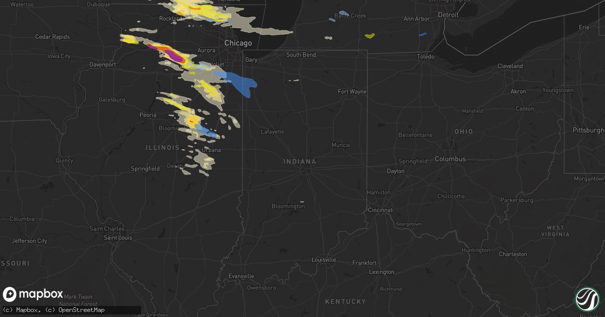
Hail Map in Indiana on September 7, 2021
Get this storm
September 7 map
$229
one time, instant access
Download today. No call, no setup
Keep the $229
Bought the map and want the full workflow? Apply the entire $229 to a subscription within 7 days. None of it is wasted.
Every map, not just this one
This buys you this map. Subscription and you get every map we run, in the markets you choose from a few cities to whole states to nationwide. Plus real-time alerts the moment a storm fires.
Contact data
Name, contact info, occupancy, even credit band for addresses in the footprint. You go from where it hit to who to call.
Become the source they trust
Unlimited branding weather history reports on demand. You already have the documented answer ready for the property owner, and you are the one who showed up with it.
Property data and RoofTrace estimates
Pull up any address you have got, its value and the exact code rules for that jurisdiction, straight from One Click Code. Then RoofTrace estimates the squares, pitch, and roof value, priced the way you price.
Storm reports in Indiana
Indiana
| Date | Description |
|---|---|
| 09/07/20214:48 PM CDT | Spotter measured wind gust of 68.2 mph at intersection of sr 49 and county road 255n. |
| 09/06/202110:58 PM CDT | At 356 PM CDT, severe thunderstorms were located along a line extending from St. John to near Lowell to Hopkins Park, moving east at 50 mph. HAZARD...70 mph wind gusts and quarter size hail. SOURCE...Trained weather spotters large tree limbs down in Peotone, Illinois around 345 PM CDT. IMPACT...Hail damage to vehicles is expected. Expect considerable tree damage. Wind damage is also likely to mobile homes, roofs, and outbuildings. Locations impacted include... Rensselaer, DeMotte, Hebron, Wheatfield, Lakes of the Four Seasons, Roselawn, Kouts, Hanging Grove, Boone Grove, Baileys Corner, Stoutsburg, Fair Oaks, Parr, Dunns Bridge and Malden.Including the following interstate... Indiana I-65 between mile markers 216 and 232. |
| 09/06/202110:28 PM CDT | At 328 PM CDT, severe thunderstorms were located along a line extending from near Frankfort to near Manteno to near Limestone, moving east at 50 mph. HAZARD...70 mph wind gusts and quarter size hail. SOURCE...Radar indicated. IMPACT...Hail damage to vehicles is expected. Expect considerable tree damage. Wind damage is also likely to mobile homes, roofs, and outbuildings. Locations impacted include... Gary, Merrillville, Chicago Heights, Schererville, Hobart, Kankakee, Crown Point, Highland, Munster, Park Forest, Matteson, Bourbonnais, Frankfort, Bradley, Cedar Lake, Steger, Lowell, Manteno, Peotone and Momence.Including the following interstates... I-57 between mile markers 302 and 341. Indiana I-65 between mile markers 233 and 258. |
All States Impacted by Hail Map on September 7, 2021
Cities Impacted by Hail Map on September 7, 2021
- Champaign, IL
- Hortonville, WI
- Black Creek, WI
- Shiocton, WI
- Walkerville, MI
- Branch, MI
- Baldwin, MI
- Wellington, TX
- Pickett, WI
- Ripon, WI
- Wellston, MI
- Brethren, MI
- Manistee, MI
- Harrietta, MI
- Bitely, MI
- Idlewild, MI
- Milton, WI
- Sobieski, WI
- Abrams, WI
- Clifton, IL
- Grand Ridge, IL
- Mazon, IL
- Somonauk, IL
- Channahon, IL
- Milledgeville, IL
- Reddick, IL
- Sublette, IL
- Sheridan, IL
- Fulton, IL
- Woosung, IL
- Shorewood, IL
- Compton, IL
- Sandwich, IL
- Sterling, IL
- Chebanse, IL
- Lee, IL
- Ransom, IL
- Cullom, IL
- Kempton, IL
- Manhattan, IL
- Shabbona, IL
- Ottawa, IL
- Emington, IL
- Seneca, IL
- South Wilmington, IL
- Coal City, IL
- Ashton, IL
- Elwood, IL
- Morrison, IL
- Kinsman, IL
- Serena, IL
- Franklin Grove, IL
- Earlville, IL
- Mendota, IL
- Clinton, IA
- Union Hill, IL
- Plano, IL
- Ashkum, IL
- Kankakee, IL
- Eldena, IL
- Bourbonnais, IL
- West Brooklyn, IL
- Verona, IL
- Peotone, IL
- Herscher, IL
- Sabula, IA
- Waterman, IL
- Braidwood, IL
- Campus, IL
- Leland, IL
- Bonfield, IL
- Yorkville, IL
- Polo, IL
- Danforth, IL
- Wilmington, IL
- Joliet, IL
- Dixon, IL
- Newark, IL
- Manteno, IL
- Marseilles, IL
- Cabery, IL
- Braceville, IL
- Mount Carroll, IL
- Thomson, IL
- Buckingham, IL
- Morris, IL
- Millington, IL
- Essex, IL
- Gardner, IL
- Amboy, IL
- Paw Paw, IL
- Gilman, IL
- Chadwick, IL
- Steward, IL
- Dwight, IL
- Minooka, IL
- Elkhart Lake, WI
- Alger, MI
- Au Gres, MI
- Omer, MI
- Standish, MI
- Cleo Springs, OK
- Ringwood, OK
- Isabella, OK
- Fairview, OK
- Reed City, MI
- Cleveland, WI
- Ludington, MI
- Hart, MI
- Custer, MI
- Sheboygan, WI
- Chase, MI
- Pentwater, MI
- Plymouth, WI
- Scottville, MI
- Edgerton, WI
- Janesville, WI
- Whitewater, WI
- Palmyra, WI
- Fort Atkinson, WI
- Hereford, AZ
- Seiling, OK
- De Pere, WI
- Greenleaf, WI
- Little Chute, WI
- Appleton, WI
- Combined Locks, WI
- Wrightstown, WI
- Seymour, WI
- Kimberly, WI
- Kaukauna, WI
- Malone, WI
- Kiel, WI
- Saint Cloud, WI
- Deming, NM
- Minonk, IL
- Benson, IL
- Flanagan, IL
- Toluca, IL
- Pontiac, IL
- Chenoa, IL
- Washburn, IL
- Gridley, IL
- El Paso, IL
- Van Dyne, WI
- Eldorado, WI
- Fond Du Lac, WI
- Rosendale, WI
- Eden, WI
- Brandon, WI
- Mount Calvary, WI
- Oakfield, WI
- Gifford, IL
- Jefferson, WI
- Cambridge, WI
- Frankfort, MI
- Beulah, MI
- Benzonia, MI
- Thompsonville, MI
- Grawn, MI
- Interlochen, MI
- Kingsley, MI
- Arcadia, MI
- Buckley, MI
- Green Bay, WI
- Suamico, WI
- Deforest, WI
- Waunakee, WI
- Elk City, KS
- Independence, KS
- Caney, KS
- Cherokee, KS
- Girard, KS
- McCune, KS
- Fife Lake, MI
- Westfield, WI
- Neshkoro, WI
- Wautoma, WI
- Montello, WI
- Berlin, WI
- Clinton, IL
- Sherman, TX
- Oswego, KS
- Columbus, KS
- Poplar Grove, IL
- Caledonia, IL
- Capron, IL
- Shepherd, MI
- Mount Pleasant, MI
- Potomac, IL
- Penfield, IL
- New Holstein, WI
- Valders, WI
- Chilton, WI
- Saint Nazianz, WI
- Rubicon, WI
- Ellsworth, IL
- Arrowsmith, IL
- Fall River, WI
- Doylestown, WI
- Juneau, WI
- Mayville, WI
- Iron Ridge, WI
- Columbus, WI
- Poynette, WI
- Rio, WI
- Theresa, WI
- Beaver Dam, WI
- Hartford, WI
- Horicon, WI
- Bear Lake, MI
- Midland, MI
- Marengo, IL
- Kewaskum, WI
- Campbellsport, WI
- Bisbee, AZ
- Union, IL
- Roscoe, IL
- Harvard, IL
- Waukegan, IL
- Clinton, WI
- Hebron, IL
- Gurnee, IL
- Williams Bay, WI
- Lake Forest, IL
- Delavan, WI
- Cary, IL
- Loves Park, IL
- Avalon, WI
- Genoa City, WI
- Ringwood, IL
- Garden Prairie, IL
- Antioch, IL
- Wauconda, IL
- Lake Geneva, WI
- Island Lake, IL
- Lake Bluff, IL
- Woodstock, IL
- Great Lakes, IL
- Fox Lake, IL
- Lake Zurich, IL
- Barrington, IL
- Elkhorn, WI
- Burlington, WI
- Libertyville, IL
- Rockton, IL
- Rockford, IL
- Crystal Lake, IL
- Ingleside, IL
- Walworth, WI
- Wonder Lake, IL
- Belvidere, IL
- North Chicago, IL
- Machesney Park, IL
- Spring Grove, IL
- Mchenry, IL
- Grayslake, IL
- Fontana, WI
- South Beloit, IL
- Darien, WI
- Lake Villa, IL
- Round Lake, IL
- Mundelein, IL
- Sharon, WI
- Beloit, WI
- Vernon Hills, IL
- Richmond, IL
- Lake City, MI
- Free Soil, MI
- Ravenna, MI
- Casnovia, MI
- Bailey, MI
- Muskegon, MI
- Pesotum, IL
- Philo, IL
- Sadorus, IL
- Tolono, IL
- Cedarburg, WI
- Grafton, WI
- East Tawas, MI
- New London, WI
- Markesan, WI
- Warner, OK
- Webbers Falls, OK
- Fredonia, KS
- Havana, KS
- Douglas, AZ
- McNeal, AZ
- Elk City, OK
- Hammon, OK
- Belleville, WI
- Cadillac, MI
- Longdale, OK
- Animas, NM
- Madison, WI
- Verona, WI
- Hersey, MI
- Sun Prairie, WI
- Manton, MI
- Mesick, MI
- Stoughton, WI
- Oregon, WI
- Evansville, WI
- Brooklyn, WI
- Tustin, MI
- Paxton, IL
- Luxemburg, WI
- Kalkaska, MI
- Mcfarland, WI
- Mount Horeb, WI
- Daisy, OK
- Pittsburg, OK
- Clayton, OK
- Tuskahoma, OK
- Kewaunee, WI
- Bellflower, IL
- Saybrook, IL
- Neodesha, KS
- Random Lake, WI
- Adell, WI
- Allenton, WI
- Shannon, IL
- Forreston, IL
- Lanark, IL
- Mount Morris, IL
- Oregon, IL
- Oconto, WI
- Lupton, MI
- Rose City, MI
- McBain, MI
- Boon, MI
- Two Rivers, WI
- Downs, IL
- Le Roy, IL
- Winnetka, IL
- Parsons, KS
- Saint Paul, KS
- Wellington, IL
- Milford, IL
- Rutland, IL
- Wenona, IL
- Dana, IL
- Long Point, IL
- Ixonia, WI
- Brodhead, WI
- Cissna Park, IL
- Onarga, IL
- Buckley, IL
- East Troy, WI
- Helenville, WI
- Dousman, WI
- Crowell, TX
- Tonkawa, OK
- Mapleton, KS
- Fulton, KS
- Saint Helen, MI
- Grant, MI
- Porum, OK
- West Branch, MI
- Luzerne, MI
- Bement, IL
- Princeton, WI
- Arlington, WI
- Randolph, WI
- Copemish, MI
- Irons, MI
- Kaleva, MI
- Onekama, MI
- Marshall, WI
- Mound City, KS
- Manawa, WI
- Menasha, WI
- Waupaca, WI
- Ogdensburg, WI
- Denmark, WI
- Mishicot, WI
- Amherst, WI
- Greenville, WI
- Maribel, WI
- Fremont, WI
- Weyauwega, WI
- Luther, MI
- Leroy, MI
- Falmouth, MI
- Marion, MI
- Cedar, MI
- Maple City, MI
- Traverse City, MI
- Honor, MI
- Glen Arbor, MI
- Empire, MI
- National City, MI
- Tawas City, MI
- Whittemore, MI
- Kawkawlin, MI
- Sanford, MI
- Linwood, MI
- Auburn, MI
- Cherry Valley, IL
- Ravenna, TX
- Manitowoc, WI
- Newton, WI
- Port Austin, MI
- Sears, MI
- Evart, MI
- Quinton, OK
- Kinta, OK
- Islandton, SC
- Okeene, OK
- Kingfisher, OK
- Hennessey, OK
- Cross Plains, WI
- Cottage Grove, WI
- New Glarus, WI
- Sheffield, IL
- Manlius, IL
- Wyanet, IL
- Mazomanie, WI
- Dane, WI
- Taloga, OK
- Oakwood, OK
- Melvin, IL
- Redgranite, WI
- Omro, WI
- Oshkosh, WI
- Green Lake, WI
- Colfax, IL
- Anchor, IL
- Cropsey, IL
- Fairbury, IL
- Coloma, WI
- Sauk City, WI
- Black Earth, WI
- Stigler, OK
- Hoopeston, IL
- Rankin, IL
- Bennington, OK
- Redfield, KS
- Clint, TX
- Oconomowoc, WI
- Lake Mills, WI
- Waterloo, WI
- Johnson Creek, WI
- Watertown, WI
- Nashville, IN
- Fountain, MI
- Merritt, MI
- Arlington, IL
- Peru, IL
- Genoa, IL
- Sibley, IL
- Fisher, IL
- Cornell, IL
- Rantoul, IL
- Dewey, IL
- Lexington, IL
- Lacon, IL
- Foosland, IL
- Bloomington, IL
- Ludlow, IL
- Varna, IL
- Cooksville, IL
- Graymont, IL
- Gibson City, IL
- Towanda, IL
- Strawn, IL
- Hudson, IL
- Mahomet, IL
- Streator, IL
- Normal, IL
- Farmer City, IL
- Neosho, WI
- Plymouth, IN
- Culver, IN
- Clare, MI
- Sierra Vista, AZ
- Cartersville, GA
- Houghton Lake, MI
- Roscommon, MI
- Prudenville, MI
- Secor, IL
- Menomonee Falls, WI
- Deerfield, WI
- Sussex, WI
- Colgate, WI
- Lannon, WI
- Hartland, WI
- Nashotah, WI
- Junction, TX
- Triumph, IL
- Dennis, KS
- Mound Valley, KS
- Cherryvale, KS
- Decatur, IL
- Mt Zion, IL
- Ames, OK
- Kohler, WI
- Sheboygan Falls, WI
- Laingsburg, MI
- Owosso, MI
- Butler, MO
- Walters, OK
- Fremont, MI
- Tuscola, IL
- Perry, OK
- Winneconne, WI
- Pine River, WI
- West Bend, WI
- Monticello, IL
- Mansfield, IL
- Ivesdale, IL
- White Heath, IL
- Villa Grove, IL
- Seymour, IL
- Atwood, IL
- Sterling, MI
- La Moille, IL
- Fredonia, WI
- Waldo, WI
- Reeseville, WI
- Burnett, WI
- Jackson, WI
- Hepler, KS
- Farlington, KS
- Fort Scott, KS
- Dalton City, IL
- Lovington, IL
- Wadsworth, IL
- Niotaze, KS
- Del Rio, TX
- Cisco, IL
- Cedar Grove, WI
- Hammond, IL
- Cerro Gordo, IL
- Argenta, IL
- Erick, OK
- Paris, MI
- Gladwin, MI
- Harrison, MI
- Lake, MI
- Farwell, MI
- Whitefield, OK
- South Boardman, MI
- Grayling, MI
- Barryton, MI
- Cascade, WI
- Saukville, WI
- Belgium, WI
- Hendrix, OK
- Freeland, MI
- Varnville, SC
- Ruffin, SC
- Ponca City, OK
- Fort Huachuca, AZ
- Lake Leelanau, MI
- Waupun, WI
- Glenbeulah, WI
- Brillion, WI
- Almond, WI
- Forrest, IL
- Eagle, WI
- Windsor, WI
- Blue Mounds, WI
- Barneveld, WI
- Middleton, WI
- Huntley, IL
- Wheeling, IL
- Juda, WI
- Trevor, WI
- Highland Park, IL
- Buffalo Grove, IL
- Arlington Heights, IL
- Delafield, WI
- Deerfield, IL
- Springfield, WI
- Mukwonago, WI
- Orfordville, WI
- Shirland, IL
- Wilmot, WI
- Blanchardville, WI
- Dodgeville, WI
- Zion, IL
- Spring Green, WI
- Big Bend, WI
- Ridgeway, WI
- Twin Lakes, WI
- Northbrook, IL
- Glencoe, IL
- Saint Joseph, MI
- Highwood, IL
- Stevensville, MI
- Lincolnshire, IL
- Muskego, WI
- Waukesha, WI
- Afton, WI
- Monroe, WI
- Durand, IL
- Waterford, WI
- Sullivan, WI
- Hogansville, GA
- Greenville, GA
- Union Grove, WI
- Kansasville, WI
- Braggs, OK
- Muskogee, OK
- Thomas, OK
- Dalton, WI
- Mio, MI
- La Mesa, NM
- Anthony, NM
- Mesquite, NM
- Vado, NM
- Howe, TX
- Neenah, WI
- Saginaw, MI
- Cambria, WI
- Arcola, IL
- Arthur, IL
- Franklin, WI
- Amoret, MO
- Shamrock, TX
- Lodi, WI
- Savanna, IL
- Salem, WI
- Thomasboro, IL
- Boswell, OK
- Lewiston, MI
- De Land, IL
- Van Orin, IL
- Utica, IL
- Ohio, IL
- Newkirk, OK
- Ivanhoe, TX
- Oxford, WI
- Pittsburg, KS
- Walnut, KS
- Little Suamico, WI
- Lena, WI
- Wild Rose, WI
- Hancock, WI
- Pearl City, IL
- Finley, OK
- Antlers, OK
- Moyers, OK
- Larsen, WI
- Chatsworth, IL
- Coleman, MI
- Butler, OK
- Quail, TX
- Oneida, WI
- Pulaski, WI
- Three Rivers, MI
- West Point, GA
- Lagrange, GA
- Oostburg, WI
- Whitehall, MI
- Twin Lake, MI
- Fruitport, MI
- Casco, WI
- New Franken, WI
- Thayer, IN
- Monee, IL
- Lake Village, IN
- Grant Park, IL
- Hebron, IN
- Morocco, IN
- Shelby, IN
- Beecher, IL
- Lowell, IN
- Pembroke Township, IL
- Schneider, IN
- Demotte, IN
- Momence, IL
- Fairwater, WI
- Hilbert, WI
- Stockbridge, WI
- Breckenridge, MI
- Saint Louis, MI
- Ithaca, MI
- Alma, MI
- Sumner, MI
- Quincy, MI
- Allen, MI
- Litchfield, MI
- Jonesville, MI
- Ovid, MI
- Fay, OK
- Bay City, MI
- Portage, MI
- Scotts, MI
- Kalamazoo, MI
- Battle Creek, MI
- Richland, MI
- Augusta, MI
- Dundee, MI
- Maybee, MI


