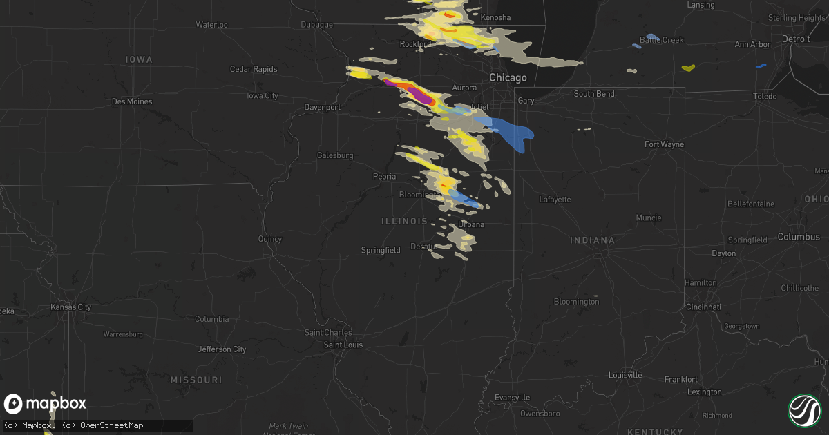
Hail Map in Illinois on September 7, 2021
Get this storm
September 7 map
$229
one time, instant access
Download today. No call, no setup
Keep the $229
Bought the map and want the full workflow? Apply the entire $229 to a subscription within 7 days. None of it is wasted.
Every map, not just this one
This buys you this map. Subscription and you get every map we run, in the markets you choose from a few cities to whole states to nationwide. Plus real-time alerts the moment a storm fires.
Contact data
Name, contact info, occupancy, even credit band for addresses in the footprint. You go from where it hit to who to call.
Become the source they trust
Unlimited branding weather history reports on demand. You already have the documented answer ready for the property owner, and you are the one who showed up with it.
Property data and RoofTrace estimates
Pull up any address you have got, its value and the exact code rules for that jurisdiction, straight from One Click Code. Then RoofTrace estimates the squares, pitch, and roof value, priced the way you price.
Storm reports in Illinois
Illinois
| Date | Description |
|---|---|
| 09/07/20216:03 PM CDT | A couple power lines down between rantoul and gifford. Time estimated by radar. |
| 09/07/20216:01 PM CDT | Time estimated from radar. |
| 09/07/20215:58 PM CDT | Reports of trees down on power lines and power lines down on roadways. |
| 09/07/20215:35 PM CDT | Widespread tree and power line damage... Hospital roof damaged... And baseball dugout destroyed in gibson city. |
| 09/07/20215:25 PM CDT | Spotter reports multiple 3 to 4 inch branches down. |
| 09/07/20215:15 PM CDT | A local report indicates 1.75 inch wind near COLFAX |
| 09/07/20215:05 PM CDT | Large healthy tree about 2 ft diamter down near fifer st and hyatt st. Time estimated by radar. |
| 09/07/20215:05 PM CDT | Several large tree limbs down on power lines. Delayed report. Time estimated by radar. |
| 09/07/20214:20 PM CDT | Large tree limbs downed in flanagan. Relayed by wmbd. Time estimated from radar. |
| 09/07/20214:18 PM CDT | Large metal outbuilding collapsed. Relayed by wmbd. Time estimated from radar. |
| 09/07/20214:11 PM CDT | A local report indicates 1.00 inch wind near MINONK |
| 09/07/20214:10 PM CDT | Report of a tree down on sb i-55 at us 6 and overturned semi truck on i-55 at arsenal. |
| 09/07/20213:45 PM CDT | Report of a 6 to 12 inch diameter tree branch down. |
| 09/07/20213:42 PM CDT | 8 inch diameter tree limbs downed. Time estimated from radar. |
| 09/07/20213:42 PM CDT | Time estimated from radar. |
| 09/07/20213:40 PM CDT | 10 to 12 power poles downed. |
| 09/07/20213:24 PM CDT | Picture of utility polls snapped at the base relayed via social media. Time is estimated from radar. |
| 09/07/20213:21 PM CDT | Report of estimated wind gusts of 50 to 60 mph with some tree limbs down. Tree limbs are estimated to be 2 inches in diameter. |
| 09/07/20213:18 PM CDT | Damage to buildings at a farm on the corner of w hoff rd and rowell ave. Also trees uprooted and corn flattened. Time estimated from radar. |
| 09/07/20213:15 PM CDT | Spotter reports tree branches down. Winds were estimated to be 60 mph. |
| 09/07/20213:10 PM CDT | Corrects time of previous report from 2 ene channahon. Report of a tree down on sb i-55 at us 6 and overturned semi truck on i-55 at arsenal. |
| 09/07/20213:10 PM CDT | Channahon village official reports widespread damage to trees and powerlines. Estimate of 100 or more trees damaged across the village with some trees uprooted. A dozen |
| 09/07/20213:10 PM CDT | An nws storm damage survey team found widespread tree damage... Including numerous downed... Across much of and near channahon. Some of these trees were downed on struc |
| 09/07/20213:08 PM CDT | Several large tree limbs snapped in channahon. Time estimated from radar. |
| 09/07/20213:07 PM CDT | Report via social media of tractor trailers overturned at a cold storage facility. Time is estimated from radar. |
| 09/07/20213:02 PM CDT | Pictures of tree branches downed on a house via social media. Time estimated by radar. |
| 09/07/20213:02 PM CDT | An nws storm damage survey team found widespread tree damage... Including numerous downed... Across much of and near minooka. Some of these trees were downed on structu |
| 09/07/20212:59 PM CDT | Report of tree branches and limbs downed by winds estimated to be 60 to 65 mph. |
| 09/07/20212:55 PM CDT | A local report indicates 72 MPH wind near 3 E LISBON |
| 09/07/20212:55 PM CDT | Report of 16 inch diameter tree snapped. Time estimated by radar. Location is approximate. |
| 09/07/20212:55 PM CDT | Wind gust of 61 mph |
| 09/07/20212:54 PM CDT | Numerous trees downed and one snapped in half along us route 6 between morris and seneca. Power pole also damaged. Time estimated from radar. |
| 09/07/20212:52 PM CDT | Report via nws chat from spotter of 3 inch diameter tree branch down near leland... Il. |
| 09/07/20212:25 PM CDT | Multiple reports of hail up to 2 inches in diameter in and near earlville. Time estimated from radar. |
| 09/07/20212:18 PM CDT | Time estimated from radar. |
| 09/07/20212:12 PM CDT | A local report indicates 2.00 inch wind near PAW PAW |
| 09/07/20212:05 PM CDT | 20 inch diameter tree downed onto road. |
| 09/07/20212:03 PM CDT | Hail damage to siding at farmstead. Time estimated by radar. |
| 09/07/20212:01 PM CDT | Updates previous hail report from compton. Hail was at a minimum 2 inches in diameter. At least six auto windshields smashed. One residence had multiple skylights smash |
| 09/07/20211:59 PM CDT | Picture of a tree down near highland park relayed via social media. |
| 09/07/20211:58 PM CDT | Photo received of hail. Also reported small dents on vehicles from the hail in town. |
| 09/07/20211:58 PM CDT | Time estimated from radar. Image was sent in via social media. |
| 09/07/20211:55 PM CDT | Video shared on social media shows part of a large tree getting snapped off at its top. Time estimated from radar. |
| 09/07/20211:54 PM CDT | Picture of large tree down and blocking darrel rd south of il-176 relayed via social media. |
| 09/07/20211:52 PM CDT | Pwk asos peak gust. |
| 09/07/20211:48 PM CDT | A local report indicates 1.00 inch wind near 3 NNW PAW PAW |
| 09/07/20211:45 PM CDT | 14 inch diameter tree snapped at base. Time estimated by radar. |
| 09/07/20211:42 PM CDT | Report relayed via nws chat of branches down... Unknown size. Time estimated by radar. |
| 09/07/20211:36 PM CDT | Multiple large branches and trees down along roberts rd. Time estimated from radar. |
| 09/07/20211:35 PM CDT | Report relayed by wtvo/wqrf. Time and location estimated from radar. |
| 09/07/20211:30 PM CDT | Time estimated from radar. |
| 09/07/20211:30 PM CDT | Numerous tree branches downed and snapped... Large branch blocking westbound lane of il-176. Time estimated from radar. |
| 09/07/20211:29 PM CDT | Time estimated by radar. Location approximated by wfo bgm... Caller only gave zip code. |
| 09/07/20211:29 PM CDT | Measured on personal weather station. |
| 09/07/20211:27 PM CDT | A local report indicates 1.50 inch wind near WOODSTOCK |
| 09/07/20211:23 PM CDT | Quarter size hail report from mping. Time estimated from radar. |
| 09/07/20211:20 PM CDT | Time estimated from radar. |
| 09/07/20211:20 PM CDT | A local report indicates 1.00 inch wind near SPRING GROVE |
| 09/07/20211:16 PM CDT | A local report indicates 1.00 inch wind near 2 E RICHMOND |
| 09/07/20211:13 PM CDT | Small tree about 6 inches in diameter snapped. Time estimated from radar. |
| 09/07/20211:13 PM CDT | Quarter size hail report from mping. Time estimated from radar. |
| 09/07/202112:59 PM CDT | Time estimated by radar. |
| 09/07/202112:55 PM CDT | Time estimated from radar. |
| 09/07/202112:44 PM CDT | Delayed report. Hail ranged from pea to 1 inch with some golfball sized. Occurred 1244-47 pm. |
| 09/07/202112:43 PM CDT | A local report indicates 1.00 inch wind near 2 W USTICK |
| 09/07/202112:41 PM CDT | Delayed report. Golfball hail for 4 minutes 1241-45 pm. |
| 09/07/202112:32 PM CDT | Picture of tree down sent via social media. Time is estimated from radar. |
| 09/07/20217:47 AM CDT | At 1246 PM CDT, a severe thunderstorm was located near Fairhaven, or near Morrison, moving east at 45 mph. HAZARD...60 mph wind gusts and quarter size hail. SOURCE...Radar indicated. IMPACT...Hail damage to vehicles is expected. Expect wind damage to roofs, siding, and trees. This severe thunderstorm will be near... Coleta around 100 PM CDT. |
| 09/07/20217:30 AM CDT | At 1229 PM CDT, severe thunderstorms were located along a line extending from near Elkhorn to near South Beloit, moving east at 60 mph. HAZARD...Quarter size hail. SOURCE...Radar indicated. IMPACT...Damage to vehicles is expected. Locations impacted include... Kenosha, Racine, Beloit, Mount Pleasant, Pleasant Prairie, Elkhorn, Delavan, Lake Geneva, Sturtevant, Union Grove, Paddock Lake, Williams Bay, Camp Lake, Winthrop Harbor, Wheatland, Genoa City, Walworth, Silver Lake, Clinton and Fontana-On-Geneva Lake. |
| 09/07/20212:04 AM CDT | At 704 PM CDT, a severe thunderstorm was located over Ashkum, or near Clifton, moving southeast at 35 mph. HAZARD...60 mph wind gusts and quarter size hail. SOURCE...Radar indicated. IMPACT...Hail damage to vehicles is expected. Expect wind damage to roofs, siding, and trees. Locations impacted include... Watseka, Gilman, Clifton, Sheldon, Ashkum, Martinton, Crescent City, Danforth, Woodland, Donovan and Iroquois.Including the following interstate... I-57 between mile markers 282 and 299. |
| 09/07/20211:09 AM CDT | At 608 PM CDT, severe thunderstorms were located along a line extending from near Rankin to 6 miles north of St. Joseph to Mahomet, moving southeast at 45 mph. HAZARD...60 mph wind gusts and nickel size hail. SOURCE...Radar indicated. IMPACT...Expect damage to roofs, siding, and trees. Severe thunderstorms will be near... Rankin around 615 PM CDT. Ogden and Potomac around 620 PM CDT. Savoy, Tolono, Rossville, Fithian and Muncie around 625 PM CDT.Other locations in the path of these severe thunderstorms includeOakwood, Fairmount, St. Joseph, Catlin, Philo, Danville, Westville,Tilton, Sidney, Belgium, Georgetown, Homer, Broadlands and Allerton.This includes the following highways... Interstate 57 between mile markers 218 and 251. Interstate 72 between mile markers 174 and 182. Interstate 74 between mile marker 169 and the Indiana border. |
| 09/07/202112:46 AM CDT | At 546 PM CDT, a severe thunderstorm was located over Mazon, or 7 miles southwest of Coal City, moving southeast at 35 mph. HAZARD...60 mph wind gusts and half dollar size hail. SOURCE...Radar indicated. IMPACT...Hail damage to vehicles is expected. Expect wind damage to roofs, siding, and trees. Locations impacted include... Kankakee, Bourbonnais, Bradley, Manteno, Braidwood, Wilmington, Coal City, Dwight, Herscher, Diamond, Limestone, Gardner, Lakewood Shores, Mazon, Braceville, Essex, South Wilmington, Godley, Bonfield and Carbon Hill.Including the following interstates... I-55 between mile markers 213 and 238. I-57 between mile markers 314 and 321.This includes... Kankakee River State Park and Olivet NazarineUniversity. |
| 09/07/202112:39 AM CDT | At 538 PM CDT, severe thunderstorms were located along a line extending from near Gibson City to near Downs, moving east at 40 mph. HAZARD...60 mph wind gusts and quarter size hail. SOURCE...Radar indicated. IMPACT...Hail damage to vehicles is expected. Expect wind damage to roofs, siding, and trees. Severe thunderstorms will be near... Rantoul around 555 PM CDT.Other locations in the path of these severe thunderstorms includeFarmer City, Saybrook, Gifford, Mansfield and Fisher.This includes the following highways... Interstate 57 between mile markers 245 and 257. Interstate 74 between mile markers 142 and 166. |
| 09/06/202111:59 PM CDT | At 458 PM CDT, severe thunderstorms were located along a line extending from near Cullom to near Lexington, moving southeast at 35 mph. HAZARD...60 mph wind gusts and quarter size hail. SOURCE...Radar indicated. IMPACT...Hail damage to vehicles is expected. Expect wind damage to roofs, siding, and trees. Locations impacted include... Paxton, Fairbury, Gibson City, Gilman, Chatsworth, Onarga, Forrest, Cissna Park, Piper City, Buckley, Melvin, Loda, Roberts, Elliott, Sibley, Thawville, Clarence, Strawn and Claytonville.Including the following interstate... I-57 between mile markers 258 and 283. |
| 09/06/202111:58 PM CDT | At 457 PM CDT, severe thunderstorms were located along a line extending from near Fairbury to near Lexington, moving southeast at 40 mph. HAZARD...60 mph wind gusts and quarter size hail. SOURCE...Radar indicated. IMPACT...Hail damage to vehicles is expected. Expect wind damage to roofs, siding, and trees. Severe thunderstorms will be near... Colfax around 515 PM CDT.Other locations in the path of these severe thunderstorms includeSaybrook, Cooksville, and Arrowsmith.This includes Interstate 55 between mile markers 173 and 182. |
| 09/06/202111:22 PM CDT | At 421 PM CDT, a severe thunderstorm was located near El Paso, or 16 miles northeast of Eureka, moving southeast at 40 mph. HAZARD...60 mph wind gusts and quarter size hail. SOURCE...Radar indicated. At 411 PM, quarter size hail was reported at Minonk. IMPACT...Hail damage to vehicles is expected. Expect wind damage to roofs, siding, and trees. This severe thunderstorm will be near... Gridley around 435 PM CDT.Other locations in the path of this severe thunderstorm includeLexington, Chenoa and Colfax.This includes the following highways... Interstate 39 between mile markers 16 and 23. Interstate 55 between mile markers 178 and 186. |
| 09/06/202111:06 PM CDT | At 406 PM CDT, severe thunderstorms were located along a line extending from 6 miles west of Herscher to near Minonk, moving southeast at 35 mph. HAZARD...60 mph wind gusts and quarter size hail. SOURCE...Radar indicated. IMPACT...Hail damage to vehicles is expected. Expect wind damage to roofs, siding, and trees. Locations impacted include... Pontiac, Dwight, Fairbury, Herscher, Clifton, Gridley, Forrest, Flanagan, Odell, Ashkum, Cullom, Cornell, Saunemin, Danforth, Rutland, Buckingham, Cabery, Kempton, Long Point and Campus.Including the following interstates... I-55 between mile markers 188 and 217. I-57 between mile markers 289 and 300. |
| 09/06/202110:53 PM CDT | At 353 PM CDT, severe thunderstorms were located along a line extending from near Wenona to near Washburn, moving east at 60 mph. HAZARD...60 mph wind gusts and quarter size hail. SOURCE...Radar indicated. IMPACT...Hail damage to vehicles is expected. Expect wind damage to roofs, siding, and trees. Severe thunderstorms will be near... Toluca around 405 PM CDT. Minonk around 410 PM CDT.This includes Interstate 39 between mile markers 21 and 38. |
| 09/06/20219:57 PM CDT | At 254 PM CDT, severe thunderstorms were located along a line extending from 8 miles northwest of Minooka to near Morris to Seneca, moving east at 55 mph. HAZARD...70 mph wind gusts and ping pong ball size hail. SOURCE...Trained weather spotters reported 2 inch diameter hail near Earlville. IMPACT...People and animals outdoors will be injured. Expect hail damage to roofs, siding, windows, and vehicles. Expect considerable tree damage. Wind damage is also likely to mobile homes, roofs, and outbuildings. Locations impacted include... Joliet, Orland Park, Tinley Park, Plainfield, Kankakee, Lockport, New Lenox, Homer Glen, Park Forest, Mokena, Bourbonnais, Frankfort, Bradley, Morris, Channahon, Minooka, Manteno, Braidwood, Wilmington and Coal City.Including the following interstates... I-55 between mile markers 226 and 256. I-57 near mile marker 307, and between mile markers 311 and 338. I-80 between mile markers 96 and 149. |
| 09/06/20219:29 PM CDT | At 228 PM CDT, severe thunderstorms were located along a line extending from Leland to Earlville, moving southeast at 35 mph. THESE ARE DESTRUCTIVE STORMS FOR Earlville, Leland, Serena, Newark, and Sheridan. HAZARD...Baseball size hail and 70 mph wind gusts. SOURCE...Radar indicated. IMPACT...People and animals outdoors will be severely injured. Expect shattered windows, extensive damage to roofs, siding, and vehicles. Locations impacted include... Sheridan, Lake Holiday, Somonauk, Earlville, Serena, Newark, Leland, Millington, Millbrook, Lisbon, Plattville, Harding and Norway. |
| 09/06/20219:15 PM CDT | At 215 PM CDT, a severe thunderstorm was located over Vernon Hills, moving east at 50 mph. HAZARD...Ping pong ball size hail and 60 mph wind gusts. SOURCE...Radar indicated. IMPACT...People and animals outdoors will be injured. Expect hail damage to roofs, siding, windows, and vehicles. Expect wind damage to roofs, siding, and trees. Locations impacted include... Waukegan, Arlington Heights, Palatine, Buffalo Grove, Wheeling, Northbrook, North Chicago, Mundelein, Highland Park, Vernon Hills, Grayslake, Libertyville, Lake Zurich, Lake Forest, Wauconda, Barrington, Deerfield, Glencoe, Long Grove and Hawthorn Woods.Including the following interstates... I-94 between mile markers 13 and 26. I-294 between mile markers 13 and 26.This includes... Great Lakes Naval Training Center, Lake County ILFairgrounds, Lake Forest College, and Ravinia Music Festival. |
| 09/06/20219:03 PM CDT | At 203 PM CDT, severe thunderstorms were located along a line extending from near Shabbona to near Sublette, moving southeast at 35 mph. HAZARD...Golf ball size hail and 60 mph wind gusts. SOURCE...Trained weather spotters. IMPACT...People and animals outdoors will be injured. Expect hail damage to roofs, siding, windows, and vehicles. Expect wind damage to roofs, siding, and trees. Locations impacted include... Aurora, Joliet, Plainfield, Oswego, Ottawa, Yorkville, Morris, Channahon, Minooka, Plano, Sandwich, Mendota, Sheridan, Montgomery, Boulder Hill, Lake Holiday, Somonauk, Earlville, Serena and Newark.Including the following interstates... I-39 between mile markers 67 and 77. I-80 between mile markers 91 and 122.This includes... Gebhard Woods State Park, Grundy County Speedwayand Fairgrounds, Tri-County Fairgrounds, and William G Stratton StatePark. |
| 09/06/20218:41 PM CDT | At 141 PM CDT, a severe thunderstorm was located over Lake Zurich, moving east at 55 mph. HAZARD...70 mph wind gusts and half dollar size hail. SOURCE...At 132 PM CDT trained weather spotters reported a 68 mph gust near Crystal Lake. IMPACT...Hail damage to vehicles is expected. Expect considerable tree damage. Wind damage is also likely to mobile homes, roofs, and outbuildings. Locations impacted include... Chicago, Arlington Heights, Evanston, Schaumburg, Palatine, Skokie, Des Plaines, Mount Prospect, Hoffman Estates, Glenview, Buffalo Grove, Wheeling, Park Ridge, Northbrook, Elk Grove Village, Niles, Lake View, Irving Park, West Ridge and Lincoln Park.Including the following interstates... I-90 between mile markers 64 and 84. I-94 between mile markers 26 and 45. I-294 between mile markers 26 and 45.This includes... Lincoln Park Zoo, Loyola University, OaktonCommunity College, Harper College, Northeastern Illinois University,Northwestern University, and Wrigley Field. |
| 09/06/20218:35 PM CDT | A local report indicates 64 MPH wind near COLES COUNTY AIRPORT |
| 09/06/20218:23 PM CDT | At 122 PM CDT, severe thunderstorms were located along a line extending from near Ashton to near Dixon, moving east at 45 mph. HAZARD...60 mph wind gusts and half dollar size hail. SOURCE...Radar indicated. IMPACT...Hail damage to vehicles is expected. Expect wind damage to roofs, siding, and trees. Locations impacted include... DeKalb, Sycamore, Dixon, Campton Hills, Rochelle, Sandwich, Amboy, Shabbona, Elburn, Cortland, Hinckley, Somonauk, Waterman, Hillcrest, Maple Park, Malta, Franklin Grove, Lily Lake, Ashton and Paw Paw.Including the following interstates... I-39 between mile markers 78 and 102. I-88 between mile markers 47 and 106.This includes... Northern Illinois University, Sandwich Fairgrounds,and Lee County Fairgrounds. |
All States Impacted by Hail Map on September 7, 2021
Cities Impacted by Hail Map on September 7, 2021
- Champaign, IL
- Hortonville, WI
- Black Creek, WI
- Shiocton, WI
- Walkerville, MI
- Branch, MI
- Baldwin, MI
- Wellington, TX
- Pickett, WI
- Ripon, WI
- Wellston, MI
- Brethren, MI
- Manistee, MI
- Harrietta, MI
- Bitely, MI
- Idlewild, MI
- Milton, WI
- Sobieski, WI
- Abrams, WI
- Clifton, IL
- Grand Ridge, IL
- Mazon, IL
- Somonauk, IL
- Channahon, IL
- Milledgeville, IL
- Reddick, IL
- Sublette, IL
- Sheridan, IL
- Fulton, IL
- Woosung, IL
- Shorewood, IL
- Compton, IL
- Sandwich, IL
- Sterling, IL
- Chebanse, IL
- Lee, IL
- Ransom, IL
- Cullom, IL
- Kempton, IL
- Manhattan, IL
- Shabbona, IL
- Ottawa, IL
- Emington, IL
- Seneca, IL
- South Wilmington, IL
- Coal City, IL
- Ashton, IL
- Elwood, IL
- Morrison, IL
- Kinsman, IL
- Serena, IL
- Franklin Grove, IL
- Earlville, IL
- Mendota, IL
- Clinton, IA
- Union Hill, IL
- Plano, IL
- Ashkum, IL
- Kankakee, IL
- Eldena, IL
- Bourbonnais, IL
- West Brooklyn, IL
- Verona, IL
- Peotone, IL
- Herscher, IL
- Sabula, IA
- Waterman, IL
- Braidwood, IL
- Campus, IL
- Leland, IL
- Bonfield, IL
- Yorkville, IL
- Polo, IL
- Danforth, IL
- Wilmington, IL
- Joliet, IL
- Dixon, IL
- Newark, IL
- Manteno, IL
- Marseilles, IL
- Cabery, IL
- Braceville, IL
- Mount Carroll, IL
- Thomson, IL
- Buckingham, IL
- Morris, IL
- Millington, IL
- Essex, IL
- Gardner, IL
- Amboy, IL
- Paw Paw, IL
- Gilman, IL
- Chadwick, IL
- Steward, IL
- Dwight, IL
- Minooka, IL
- Elkhart Lake, WI
- Alger, MI
- Au Gres, MI
- Omer, MI
- Standish, MI
- Cleo Springs, OK
- Ringwood, OK
- Isabella, OK
- Fairview, OK
- Reed City, MI
- Cleveland, WI
- Ludington, MI
- Hart, MI
- Custer, MI
- Sheboygan, WI
- Chase, MI
- Pentwater, MI
- Plymouth, WI
- Scottville, MI
- Edgerton, WI
- Janesville, WI
- Whitewater, WI
- Palmyra, WI
- Fort Atkinson, WI
- Hereford, AZ
- Seiling, OK
- De Pere, WI
- Greenleaf, WI
- Little Chute, WI
- Appleton, WI
- Combined Locks, WI
- Wrightstown, WI
- Seymour, WI
- Kimberly, WI
- Kaukauna, WI
- Malone, WI
- Kiel, WI
- Saint Cloud, WI
- Deming, NM
- Minonk, IL
- Benson, IL
- Flanagan, IL
- Toluca, IL
- Pontiac, IL
- Chenoa, IL
- Washburn, IL
- Gridley, IL
- El Paso, IL
- Van Dyne, WI
- Eldorado, WI
- Fond Du Lac, WI
- Rosendale, WI
- Eden, WI
- Brandon, WI
- Mount Calvary, WI
- Oakfield, WI
- Gifford, IL
- Jefferson, WI
- Cambridge, WI
- Frankfort, MI
- Beulah, MI
- Benzonia, MI
- Thompsonville, MI
- Grawn, MI
- Interlochen, MI
- Kingsley, MI
- Arcadia, MI
- Buckley, MI
- Green Bay, WI
- Suamico, WI
- Deforest, WI
- Waunakee, WI
- Elk City, KS
- Independence, KS
- Caney, KS
- Cherokee, KS
- Girard, KS
- McCune, KS
- Fife Lake, MI
- Westfield, WI
- Neshkoro, WI
- Wautoma, WI
- Montello, WI
- Berlin, WI
- Clinton, IL
- Sherman, TX
- Oswego, KS
- Columbus, KS
- Poplar Grove, IL
- Caledonia, IL
- Capron, IL
- Shepherd, MI
- Mount Pleasant, MI
- Potomac, IL
- Penfield, IL
- New Holstein, WI
- Valders, WI
- Chilton, WI
- Saint Nazianz, WI
- Rubicon, WI
- Ellsworth, IL
- Arrowsmith, IL
- Fall River, WI
- Doylestown, WI
- Juneau, WI
- Mayville, WI
- Iron Ridge, WI
- Columbus, WI
- Poynette, WI
- Rio, WI
- Theresa, WI
- Beaver Dam, WI
- Hartford, WI
- Horicon, WI
- Bear Lake, MI
- Midland, MI
- Marengo, IL
- Kewaskum, WI
- Campbellsport, WI
- Bisbee, AZ
- Union, IL
- Roscoe, IL
- Harvard, IL
- Waukegan, IL
- Clinton, WI
- Hebron, IL
- Gurnee, IL
- Williams Bay, WI
- Lake Forest, IL
- Delavan, WI
- Cary, IL
- Loves Park, IL
- Avalon, WI
- Genoa City, WI
- Ringwood, IL
- Garden Prairie, IL
- Antioch, IL
- Wauconda, IL
- Lake Geneva, WI
- Island Lake, IL
- Lake Bluff, IL
- Woodstock, IL
- Great Lakes, IL
- Fox Lake, IL
- Lake Zurich, IL
- Barrington, IL
- Elkhorn, WI
- Burlington, WI
- Libertyville, IL
- Rockton, IL
- Rockford, IL
- Crystal Lake, IL
- Ingleside, IL
- Walworth, WI
- Wonder Lake, IL
- Belvidere, IL
- North Chicago, IL
- Machesney Park, IL
- Spring Grove, IL
- Mchenry, IL
- Grayslake, IL
- Fontana, WI
- South Beloit, IL
- Darien, WI
- Lake Villa, IL
- Round Lake, IL
- Mundelein, IL
- Sharon, WI
- Beloit, WI
- Vernon Hills, IL
- Richmond, IL
- Lake City, MI
- Free Soil, MI
- Ravenna, MI
- Casnovia, MI
- Bailey, MI
- Muskegon, MI
- Pesotum, IL
- Philo, IL
- Sadorus, IL
- Tolono, IL
- Cedarburg, WI
- Grafton, WI
- East Tawas, MI
- New London, WI
- Markesan, WI
- Warner, OK
- Webbers Falls, OK
- Fredonia, KS
- Havana, KS
- Douglas, AZ
- McNeal, AZ
- Elk City, OK
- Hammon, OK
- Belleville, WI
- Cadillac, MI
- Longdale, OK
- Animas, NM
- Madison, WI
- Verona, WI
- Hersey, MI
- Sun Prairie, WI
- Manton, MI
- Mesick, MI
- Stoughton, WI
- Oregon, WI
- Evansville, WI
- Brooklyn, WI
- Tustin, MI
- Paxton, IL
- Luxemburg, WI
- Kalkaska, MI
- Mcfarland, WI
- Mount Horeb, WI
- Daisy, OK
- Pittsburg, OK
- Clayton, OK
- Tuskahoma, OK
- Kewaunee, WI
- Bellflower, IL
- Saybrook, IL
- Neodesha, KS
- Random Lake, WI
- Adell, WI
- Allenton, WI
- Shannon, IL
- Forreston, IL
- Lanark, IL
- Mount Morris, IL
- Oregon, IL
- Oconto, WI
- Lupton, MI
- Rose City, MI
- McBain, MI
- Boon, MI
- Two Rivers, WI
- Downs, IL
- Le Roy, IL
- Winnetka, IL
- Parsons, KS
- Saint Paul, KS
- Wellington, IL
- Milford, IL
- Rutland, IL
- Wenona, IL
- Dana, IL
- Long Point, IL
- Ixonia, WI
- Brodhead, WI
- Cissna Park, IL
- Onarga, IL
- Buckley, IL
- East Troy, WI
- Helenville, WI
- Dousman, WI
- Crowell, TX
- Tonkawa, OK
- Mapleton, KS
- Fulton, KS
- Saint Helen, MI
- Grant, MI
- Porum, OK
- West Branch, MI
- Luzerne, MI
- Bement, IL
- Princeton, WI
- Arlington, WI
- Randolph, WI
- Copemish, MI
- Irons, MI
- Kaleva, MI
- Onekama, MI
- Marshall, WI
- Mound City, KS
- Manawa, WI
- Menasha, WI
- Waupaca, WI
- Ogdensburg, WI
- Denmark, WI
- Mishicot, WI
- Amherst, WI
- Greenville, WI
- Maribel, WI
- Fremont, WI
- Weyauwega, WI
- Luther, MI
- Leroy, MI
- Falmouth, MI
- Marion, MI
- Cedar, MI
- Maple City, MI
- Traverse City, MI
- Honor, MI
- Glen Arbor, MI
- Empire, MI
- National City, MI
- Tawas City, MI
- Whittemore, MI
- Kawkawlin, MI
- Sanford, MI
- Linwood, MI
- Auburn, MI
- Cherry Valley, IL
- Ravenna, TX
- Manitowoc, WI
- Newton, WI
- Port Austin, MI
- Sears, MI
- Evart, MI
- Quinton, OK
- Kinta, OK
- Islandton, SC
- Okeene, OK
- Kingfisher, OK
- Hennessey, OK
- Cross Plains, WI
- Cottage Grove, WI
- New Glarus, WI
- Sheffield, IL
- Manlius, IL
- Wyanet, IL
- Mazomanie, WI
- Dane, WI
- Taloga, OK
- Oakwood, OK
- Melvin, IL
- Redgranite, WI
- Omro, WI
- Oshkosh, WI
- Green Lake, WI
- Colfax, IL
- Anchor, IL
- Cropsey, IL
- Fairbury, IL
- Coloma, WI
- Sauk City, WI
- Black Earth, WI
- Stigler, OK
- Hoopeston, IL
- Rankin, IL
- Bennington, OK
- Redfield, KS
- Clint, TX
- Oconomowoc, WI
- Lake Mills, WI
- Waterloo, WI
- Johnson Creek, WI
- Watertown, WI
- Nashville, IN
- Fountain, MI
- Merritt, MI
- Arlington, IL
- Peru, IL
- Genoa, IL
- Sibley, IL
- Fisher, IL
- Cornell, IL
- Rantoul, IL
- Dewey, IL
- Lexington, IL
- Lacon, IL
- Foosland, IL
- Bloomington, IL
- Ludlow, IL
- Varna, IL
- Cooksville, IL
- Graymont, IL
- Gibson City, IL
- Towanda, IL
- Strawn, IL
- Hudson, IL
- Mahomet, IL
- Streator, IL
- Normal, IL
- Farmer City, IL
- Neosho, WI
- Plymouth, IN
- Culver, IN
- Clare, MI
- Sierra Vista, AZ
- Cartersville, GA
- Houghton Lake, MI
- Roscommon, MI
- Prudenville, MI
- Secor, IL
- Menomonee Falls, WI
- Deerfield, WI
- Sussex, WI
- Colgate, WI
- Lannon, WI
- Hartland, WI
- Nashotah, WI
- Junction, TX
- Triumph, IL
- Dennis, KS
- Mound Valley, KS
- Cherryvale, KS
- Decatur, IL
- Mt Zion, IL
- Ames, OK
- Kohler, WI
- Sheboygan Falls, WI
- Laingsburg, MI
- Owosso, MI
- Butler, MO
- Walters, OK
- Fremont, MI
- Tuscola, IL
- Perry, OK
- Winneconne, WI
- Pine River, WI
- West Bend, WI
- Monticello, IL
- Mansfield, IL
- Ivesdale, IL
- White Heath, IL
- Villa Grove, IL
- Seymour, IL
- Atwood, IL
- Sterling, MI
- La Moille, IL
- Fredonia, WI
- Waldo, WI
- Reeseville, WI
- Burnett, WI
- Jackson, WI
- Hepler, KS
- Farlington, KS
- Fort Scott, KS
- Dalton City, IL
- Lovington, IL
- Wadsworth, IL
- Niotaze, KS
- Del Rio, TX
- Cisco, IL
- Cedar Grove, WI
- Hammond, IL
- Cerro Gordo, IL
- Argenta, IL
- Erick, OK
- Paris, MI
- Gladwin, MI
- Harrison, MI
- Lake, MI
- Farwell, MI
- Whitefield, OK
- South Boardman, MI
- Grayling, MI
- Barryton, MI
- Cascade, WI
- Saukville, WI
- Belgium, WI
- Hendrix, OK
- Freeland, MI
- Varnville, SC
- Ruffin, SC
- Ponca City, OK
- Fort Huachuca, AZ
- Lake Leelanau, MI
- Waupun, WI
- Glenbeulah, WI
- Brillion, WI
- Almond, WI
- Forrest, IL
- Eagle, WI
- Windsor, WI
- Blue Mounds, WI
- Barneveld, WI
- Middleton, WI
- Huntley, IL
- Wheeling, IL
- Juda, WI
- Trevor, WI
- Highland Park, IL
- Buffalo Grove, IL
- Arlington Heights, IL
- Delafield, WI
- Deerfield, IL
- Springfield, WI
- Mukwonago, WI
- Orfordville, WI
- Shirland, IL
- Wilmot, WI
- Blanchardville, WI
- Dodgeville, WI
- Zion, IL
- Spring Green, WI
- Big Bend, WI
- Ridgeway, WI
- Twin Lakes, WI
- Northbrook, IL
- Glencoe, IL
- Saint Joseph, MI
- Highwood, IL
- Stevensville, MI
- Lincolnshire, IL
- Muskego, WI
- Waukesha, WI
- Afton, WI
- Monroe, WI
- Durand, IL
- Waterford, WI
- Sullivan, WI
- Hogansville, GA
- Greenville, GA
- Union Grove, WI
- Kansasville, WI
- Braggs, OK
- Muskogee, OK
- Thomas, OK
- Dalton, WI
- Mio, MI
- La Mesa, NM
- Anthony, NM
- Mesquite, NM
- Vado, NM
- Howe, TX
- Neenah, WI
- Saginaw, MI
- Cambria, WI
- Arcola, IL
- Arthur, IL
- Franklin, WI
- Amoret, MO
- Shamrock, TX
- Lodi, WI
- Savanna, IL
- Salem, WI
- Thomasboro, IL
- Boswell, OK
- Lewiston, MI
- De Land, IL
- Van Orin, IL
- Utica, IL
- Ohio, IL
- Newkirk, OK
- Ivanhoe, TX
- Oxford, WI
- Pittsburg, KS
- Walnut, KS
- Little Suamico, WI
- Lena, WI
- Wild Rose, WI
- Hancock, WI
- Pearl City, IL
- Finley, OK
- Antlers, OK
- Moyers, OK
- Larsen, WI
- Chatsworth, IL
- Coleman, MI
- Butler, OK
- Quail, TX
- Oneida, WI
- Pulaski, WI
- Three Rivers, MI
- West Point, GA
- Lagrange, GA
- Oostburg, WI
- Whitehall, MI
- Twin Lake, MI
- Fruitport, MI
- Casco, WI
- New Franken, WI
- Thayer, IN
- Monee, IL
- Lake Village, IN
- Grant Park, IL
- Hebron, IN
- Morocco, IN
- Shelby, IN
- Beecher, IL
- Lowell, IN
- Pembroke Township, IL
- Schneider, IN
- Demotte, IN
- Momence, IL
- Fairwater, WI
- Hilbert, WI
- Stockbridge, WI
- Breckenridge, MI
- Saint Louis, MI
- Ithaca, MI
- Alma, MI
- Sumner, MI
- Quincy, MI
- Allen, MI
- Litchfield, MI
- Jonesville, MI
- Ovid, MI
- Fay, OK
- Bay City, MI
- Portage, MI
- Scotts, MI
- Kalamazoo, MI
- Battle Creek, MI
- Richland, MI
- Augusta, MI
- Dundee, MI
- Maybee, MI


