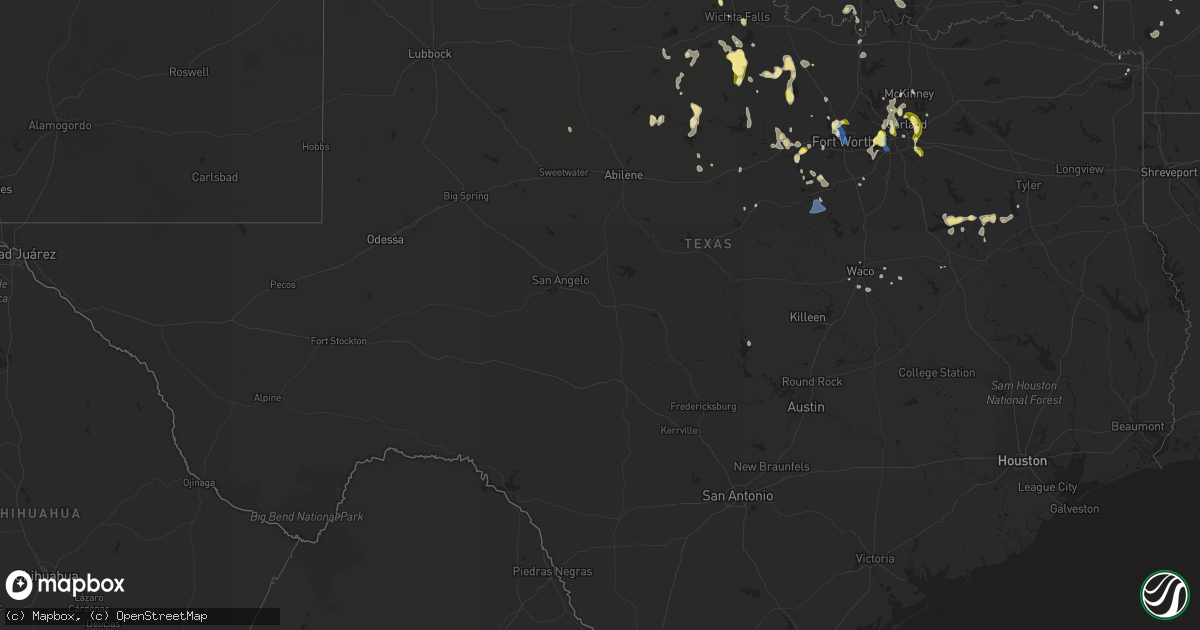
Hail Map in Texas on September 4, 2022
Get this storm
September 4 map
$229
one time, instant access
Download today. No call, no setup
Keep the $229
Bought the map and want the full workflow? Apply the entire $229 to a subscription within 7 days. None of it is wasted.
Every map, not just this one
This buys you this map. Subscription and you get every map we run, in the markets you choose from a few cities to whole states to nationwide. Plus real-time alerts the moment a storm fires.
Contact data
Name, contact info, occupancy, even credit band for addresses in the footprint. You go from where it hit to who to call.
Become the source they trust
Unlimited branding weather history reports on demand. You already have the documented answer ready for the property owner, and you are the one who showed up with it.
Property data and RoofTrace estimates
Pull up any address you have got, its value and the exact code rules for that jurisdiction, straight from One Click Code. Then RoofTrace estimates the squares, pitch, and roof value, priced the way you price.
Storm reports in Texas
Texas
| Date | Description |
|---|---|
| 09/04/20224:16 PM CDT | Minor roof damage off old fort worth road. |
| 09/04/20224:16 PM CDT | Trees down along tin top highway. |
| 09/04/20223:45 PM CDT | Report from mping: quarter |
| 09/04/20223:30 PM CDT | Aprswxnet site dw5699 in heath measured a 60 mph wind gust. |
| 09/04/20223:30 PM CDT | 4-inch diameter limbs knocked down. |
| 09/04/20223:27 PM CDT | 64 mph wind gust reported at the dallas executive airport. |
| 09/04/20223:21 PM CDT | Delayed report: social media report significant tree damage at the dallas zoo. |
| 09/04/20223:18 PM CDT | Delayed report: several large trees branches down in the lakewood height neighborhood in east dallas. |
| 09/04/20223:15 PM CDT | A local report indicates 1.25 inch wind near 3 ESE SACHSE |
| 09/04/20223:14 PM CDT | Delayed report: damage to an apartment complex near royal ln and abrams road. Storms knocked down bricks from walls. |
| 09/04/20223:13 PM CDT | Nickel and quarter size hail along with 60 mph winds reported in runaway bay. |
| 09/04/20223:12 PM CDT | Report from mping: 3-inch tree limbs broken. |
| 09/04/20223:04 PM CDT | Report from mping: quarter |
| 09/04/20223:00 PM CDT | Multiple homes with roof damage. |
| 09/04/20222:56 PM CDT | Several 1 to 3 inch tree limbs broken. |
| 09/04/20222:50 PM CDT | 60 mph wind gust recorded at meacham international airport. |
| 09/04/20222:45 PM CDT | Seven power poles blown over... Some laying on homes. |
| 09/04/20222:42 PM CDT | Spotter reported quarter to half dollar size hail and estimated 65 mph winds along i-35. |
| 09/04/20226:41 AM CDT | At 1140 AM CDT, a severe thunderstorm was located 6 miles northeast of Burneyville, moving south at 20 mph. Another severe storm was located near Lone Grove. HAZARD...60 mph wind gusts and quarter size hail. SOURCE...Radar indicated. IMPACT...Hail damage to vehicles is expected. Expect wind damage to roofs, siding, and trees. Locations impacted include... Ardmore, Marietta, Lone Grove, Wilson, Dickson, Thackerville, Leon, Overbrook, Rubottom, Lake Murray and Burneyville. |
| 09/04/20221:32 AM CDT | At 631 PM CDT, a severe thunderstorm was located over Lott, or 11 miles southwest of Marlin, moving south at 15 mph. HAZARD...60 mph wind gusts and penny size hail. SOURCE...Radar indicated. IMPACT...Expect damage to roofs, siding, and trees. Locations impacted include... Temple, Hewitt, Robinson, Marlin, Morgan's Point Resort, Lorena, Troy, Bruceville-Eddy, Rosebud, Moody, Riesel, Lott, Golinda, Thornton and Kosse.This includes Interstate 35 between mile markers 299 and 327. |
| 09/04/202212:47 AM CDT | At 547 PM CDT, a severe thunderstorm was located 11 miles south of Trinidad, or 19 miles north of Fairfield, moving southeast at 15 mph. HAZARD...60 mph wind gusts and quarter size hail. SOURCE...Radar indicated. IMPACT...Hail damage to vehicles is expected. Expect wind damage to roofs, siding, and trees. Locations impacted include... Fairfield and Fairfield Lake State Park. |
| 09/04/202212:08 AM CDT | At 508 PM CDT, a severe thunderstorm was located 5 miles north of Iowa Park, moving southeast at 30 mph. HAZARD...60 mph wind gusts and quarter size hail. SOURCE...Radar indicated. IMPACT...Hail damage to vehicles is expected. Expect wind damage to roofs, siding, and trees. Locations impacted include... Wichita Falls, Burkburnett, Iowa Park, Sheppard AFB, Lakeside City and Pleasant Valley. |
| 09/04/202212:03 AM CDT | At 503 PM CDT, a severe thunderstorm was located near Crystal Falls, or 13 miles north of Breckenridge, moving south at 15 mph. HAZARD...60 mph wind gusts and half dollar size hail. SOURCE...Radar indicated. IMPACT...Hail damage to vehicles is expected. Expect wind damage to roofs, siding, and trees. Locations impacted include... Breckenridge, Crystal Falls and Us-180 Near The Shackelford- Stephens County Line. |
| 09/03/202211:50 PM CDT | At 449 PM CDT, a severe thunderstorm was located near Cleburne, moving southeast at 15 mph. HAZARD...60 mph wind gusts. SOURCE...Radar indicated. IMPACT...Expect damage to roofs, siding, and trees. Locations impacted include... Cleburne, Granbury, Pecan Plantation, Glen Rose, Blum, Cleburne State Park, Dinosaur Valley State Park, Rio Vista and Walnut Springs. |
| 09/03/202211:00 PM CDT | At 400 PM CDT, a severe thunderstorm was located 4 miles west of Jolly, moving south at 15 mph. HAZARD...60 mph wind gusts and quarter size hail. SOURCE...Radar indicated. IMPACT...Hail damage to vehicles is expected. Expect wind damage to roofs, siding, and trees. Locations impacted include... Southeastern Wichita Falls, Scotland, Dean, Jolly and Lake Arrowhead. |
| 09/03/202210:57 PM CDT | At 357 PM CDT, a severe thunderstorm was located 7 miles south of Windthorst, or 12 miles southeast of Archer City, moving southeast at 25 mph. HAZARD...60 mph wind gusts and quarter size hail. SOURCE...Radar indicated. IMPACT...Hail damage to vehicles is expected. Expect wind damage to roofs, siding, and trees. Locations impacted include... Bryson. |
| 09/03/202210:47 PM CDT | At 347 PM CDT, a severe thunderstorm was located near Windthorst, moving south at 15 mph. HAZARD...60 mph wind gusts and quarter size hail. SOURCE...Radar indicated. IMPACT...Hail damage to vehicles is expected. Expect wind damage to roofs, siding, and trees. Locations impacted include... Archer City, Scotland, Windthorst and Shannon. |
| 09/03/202210:39 PM CDT | At 339 PM CDT, severe thunderstorms were located along a line extending from near Forney to near Desoto to near Rendon, moving south at 35 mph. HAZARD...60 mph wind gusts and quarter size hail. SOURCE...Trained weather spotters. IMPACT...Hail damage to vehicles is expected. Expect wind damage to roofs, siding, and trees. Locations impacted include... Dallas, Fort Worth, Arlington, Garland, Irving, Grand Prairie, Mesquite, Mansfield, Desoto, Cedar Hill, Duncanville, Rockwall, Lancaster, Waxahachie, Balch Springs, Ennis, Midlothian, Terrell, Seagoville and Forney. |
| 09/03/202210:32 PM CDT | At 331 PM CDT, severe thunderstorms were located along a line extending from near Aledo to 8 miles south of Cool, moving south at 15 mph. HAZARD...60 mph wind gusts and quarter size hail. SOURCE...Radar indicated. IMPACT...Hail damage to vehicles is expected. Expect wind damage to roofs, siding, and trees. Locations impacted include... Weatherford, Mineral Wells, Granbury, Mineral Wells and surrounding areasThis includes the following highways... Interstate 20 between mile markers 390 and 422. Interstate 30 near mile marker 1. |
| 09/03/202210:17 PM CDT | At 316 PM CDT, a severe thunderstorm was located near Grand Prairie, moving south at 20 mph. HAZARD...60 mph wind gusts and half dollar size hail. SOURCE...Trained weather spotters. IMPACT...Hail damage to vehicles is expected. Expect wind damage to roofs, siding, and trees. Locations impacted include... Fort Worth, Arlington, Irving, Grand Prairie, Mansfield, Euless, Bedford, Cedar Hill, Hurst, Rendon, Pantego and Cedar Hill State Park.This includes the following highways... Interstate 20 between mile markers 446 and 457. Interstate 30 between mile markers 24 and 35. |
| 09/03/202210:13 PM CDT | At 312 PM CDT, a severe thunderstorm was located near Runaway Bay, moving south at 15 mph. HAZARD...60 mph wind gusts and quarter size hail. SOURCE...Radar indicated. IMPACT...Hail damage to vehicles is expected. Expect wind damage to roofs, siding, and trees. Locations impacted include... Bridgeport, Springtown, Paradise, Poolville, Boonsville, Cottondale, Runaway Bay, Lake Bridgeport and Sanctuary. |
| 09/03/20229:43 PM CDT | At 242 PM CDT, a severe thunderstorm was located over Plano, moving south at 15 mph. HAZARD...60 mph wind gusts and quarter size hail. SOURCE...Radar indicated. IMPACT...Hail damage to vehicles is expected. Expect wind damage to roofs, siding, and trees. Locations impacted include... Dallas, Plano, Garland, Irving, Grand Prairie, Mesquite, McKinney, Carrollton, Frisco, Richardson, Lewisville, Allen, Rowlett, Desoto, Cedar Hill, Wylie, Coppell, Duncanville, Rockwall and Lancaster. |
| 09/03/20229:32 PM CDT | At 232 PM CDT, a severe thunderstorm was located over Saginaw, moving south at 15 mph. HAZARD...60 mph wind gusts and penny size hail. SOURCE...Radar indicated. IMPACT...Expect damage to roofs, siding, and trees. Locations impacted include... Fort Worth, Arlington, Grand Prairie, Mansfield, Euless, Bedford, Grapevine, Haltom City, Keller, Hurst, Burleson, Southlake, Watauga, Colleyville, Benbrook, Saginaw, White Settlement, Crowley, Forest Hill and Azle. |
All States Impacted by Hail Map on September 4, 2022
Cities Impacted by Hail Map on September 4, 2022
- Eagletown, OK
- Rugby, ND
- Castaic, CA
- Burneyville, OK
- Marietta, OK
- Overbrook, OK
- Mena, AR
- Towner, ND
- Thackerville, OK
- Wichita Falls, TX
- Riesel, TX
- Healdton, OK
- Rockwall, TX
- Sachse, TX
- Wylie, TX
- Rowlett, TX
- Garland, TX
- Weatherford, TX
- Jacksboro, TX
- Windthorst, TX
- Olney, TX
- Henrietta, TX
- Lakeview, TX
- Fort Worth, TX
- Haslet, TX
- Bowie, TX
- Breckenridge, TX
- Woodson, TX
- Graham, TX
- Asher, OK
- Wister, OK
- Granbury, TX
- Cleburne, TX
- Lorena, TX
- Waco, TX
- Arkadelphia, AR
- Okolona, AR
- Seymour, TX
- Iowa Park, TX
- Gainesville, TX
- Texarkana, TX
- Azle, TX
- Springtown, TX
- Throckmorton, TX
- Albany, TX
- Fulton, AR
- Saratoga, AR
- Loving, TX
- Cisco, TX
- Eastland, TX
- Irving, TX
- Cedar Hill, TX
- Grand Prairie, TX
- Dallas, TX
- Teague, TX
- Mcalester, OK
- Madill, OK
- Kingston, OK
- Rhome, TX
- Decatur, TX
- Royse City, TX
- Rotan, TX
- Groesbeck, TX
- Athens, TX
- Chico, TX
- Sunset, TX
- Grandview, TX
- Watson, OK
- Kerens, TX
- Larue, TX
- Montalba, TX
- Palestine, TX
- Chilton, TX
- Richardson, TX
- Allen, TX
- Plano, TX
- Godley, TX
- Red Oak, OK
- Memphis, TX
- Frankston, TX
- Burnet, TX
- Millsap, TX
- Graford, TX
- Bryson, TX
- Canyon Country, CA
- De Queen, AR
- Gillham, AR
- Grannis, AR
- Frisco, TX
- Scotland, TX
- Dublin, TX
- Mart, TX
- Vandervoort, AR
- Cove, AR
- Santa Clarita, CA
- Mineral Wells, TX
- Aledo, TX
- Mesquite, TX
- Venus, TX
- Ardmore, OK
- Norman, OK
- Nashville, AR
- Valley View, TX
- Caddo Gap, AR
- Oklahoma City, OK
- Bridgeport, TX
- Mckinney, TX
- Forney, TX
- Sunnyvale, TX
- Holliday, TX
- Bullhead City, AZ
- Golden Valley, AZ
- Newcastle, TX
- Lipan, TX
- Archer City, TX
- Bismarck, AR
- Bullard, TX
- Fairfield, TX
- Streetman, TX
- Westhope, ND
- Seagoville, TX
- McCaskill, AR
- Lone Grove, OK
- Carrollton, TX
- Addison, TX
- The Colony, TX
- Crandall, TX
- Malakoff, TX
- Princeton, TX
- Keota, OK
- Talihina, OK
- Woodway, TX
- Hooks, TX
- Pauls Valley, OK
- Paoli, OK
- Mineral Springs, AR
- Ozan, AR
- Columbus, AR
- Mingus, TX
- Ranger, TX
- Tennessee Colony, TX
- Keller, TX
- Youngstown, OH
- Kopperl, TX
- Morgan, TX


