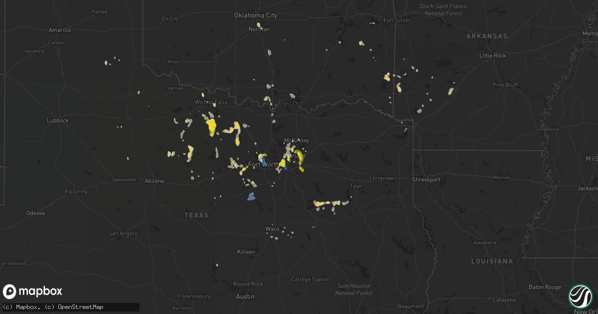
Hail Map on September 4, 2022
Get this storm
September 4 map
$229
one time, instant access
Download today. No call, no setup
Keep the $229
Bought the map and want the full workflow? Apply the entire $229 to a subscription within 7 days. None of it is wasted.
Every map, not just this one
This buys you this map. Subscription and you get every map we run, in the markets you choose from a few cities to whole states to nationwide. Plus real-time alerts the moment a storm fires.
Contact data
Name, contact info, occupancy, even credit band for addresses in the footprint. You go from where it hit to who to call.
Become the source they trust
Unlimited branding weather history reports on demand. You already have the documented answer ready for the property owner, and you are the one who showed up with it.
Property data and RoofTrace estimates
Pull up any address you have got, its value and the exact code rules for that jurisdiction, straight from One Click Code. Then RoofTrace estimates the squares, pitch, and roof value, priced the way you price.
States Impacted by Hail Map on September 4, 2022
Storm reports
Arizona
| Date | Description |
|---|---|
| 09/04/20226:56 PM CDT | A 73 mph gust was measured by a storm chaser near i40 and yucca. |
| 09/04/20226:45 PM CDT | Wind damage to a mobile home shared on social media. Time estimated. |
| 09/04/202212:01 AM CDT | At 501 PM MST, a severe thunderstorm was located 10 miles north of Blake Ranch Road, or 12 miles northeast of Kingman, moving west at 35 mph. HAZARD...60 mph wind gusts and quarter size hail. SOURCE...Radar indicated. IMPACT...Hail damage to vehicles is expected. Expect wind damage to roofs and trees. Locations impacted include... Kingman, New Kingman-Butler and Golden Valley. This includes Interstate 40 in Arizona between mile markers 44 and61. |
| 09/03/202211:34 PM CDT | At 433 PM MST, a severe thunderstorm was located 15 miles west of Wikieup, moving southwest at 20 mph. HAZARD...60 mph wind gusts and quarter size hail. SOURCE...Radar indicated. IMPACT...Hail damage to vehicles is expected. Expect wind damage to roofs and trees. This severe thunderstorm will remain over mainly rural areas of southern Mohave County, including Alamo Road. |
| 09/03/20228:50 PM CDT | Power outage in south lake havasu city due to thunderstorm related wind damage to power lines. |
| 09/03/20228:50 PM CDT | Power outage in yucca due to thunderstorm related wind damage to power lines. |
| 09/03/20228:50 PM CDT | 10 power poles down due to thunderstorm related wind gusts from mohave valley to bullhead city. Exact location estimated. |
| 09/03/20228:45 PM CDT | Arizona met site recorded a 59 mph wind gust between 1800 and 1900. Exact time estimated by nearby damage reports. |
| 09/03/20228:15 PM CDT | Dust storm with 15 feet visibility coupled with wind gusts between 60 and 80 miles per hour. Dust continued for over 15 minutes. |
| 09/03/20228:00 PM CDT | Power lines down in western golden valley. Exact location estimated. |
| 09/03/20227:40 PM CDT | Corrects previous tstm wnd dmg report from 3 wsw lake havasu city. Two overturned boats on lake havasu as a result of thunderstorm related wind gusts. Injuries unknown |
| 09/03/20227:36 PM CDT | Two overturned boats on lake havasu as a result of thunderstorm related wind gusts. Injuries unknown at this time. Exact location estimated. |
| 09/03/20227:25 PM CDT | London bridge mesonet site recorded gust to 58 mph with thunderstorm gust front. Data courtesy of earth networks. |
| 09/03/20227:19 PM CDT | A gust to 75 mph was recorded at kingman airport at 519 pm mst. Gusts initially reached 60 mph at 507 pm then dropped below 58 mph by 525 pm. |
Ohio
| Date | Description |
|---|---|
| 09/04/20225:00 PM CDT | Video from wmfj viewer shows minor debris being lifted near southern park mall in boardman. Possible weak tornado. |
California
| Date | Description |
|---|---|
| 09/04/20226:00 PM CDT | Mesonet station se032 castaic lake |
| 09/04/20226:00 PM CDT | Mesonet station se109 castaic rec |
| 09/04/20223:46 AM CDT | At 845 PM PDT, a severe thunderstorm was located 12 miles northeast of Ludlow, or 22 miles southwest of Kelso, moving west at 30 mph. HAZARD...60 mph wind gusts and quarter size hail. SOURCE...Radar indicated. IMPACT...Hail damage to vehicles is expected. Expect wind damage to roofs and trees. Locations impacted include... Ludlow.This includes Interstate 40 in California between mile markers 30 and62. |
| 09/04/20222:31 AM CDT | At 730 PM PDT, a severe thunderstorm was located near Essex, or 17 miles southeast of Mitchell Caverns, moving west at 10 mph. HAZARD...60 mph wind gusts and quarter size hail. SOURCE...Radar indicated. IMPACT...Hail damage to vehicles is expected. Expect wind damage to roofs and trees. Locations impacted include... Essex.This includes Interstate 40 in California between mile markers 87 and105. |
| 09/03/202211:37 PM CDT | At 437 PM PDT, a severe thunderstorm was located near Palmdale, moving northwest at 15 mph. HAZARD...60 mph wind gusts and penny size hail. SOURCE...Radar indicated. IMPACT...Expect damage to roofs, siding, and trees. Locations impacted include... Lancaster... Palmdale... Quartz Hill... and Desert View Highlands. |
| 09/03/202211:34 PM CDT | At 433 PM PDT, a severe thunderstorm was located 14 miles north of Fillmore, moving northwest at 20 mph. HAZARD...60 mph wind gusts and penny size hail. SOURCE...Radar and automated weather station. IMPACT...Expect damage to roofs, siding, and trees. Locations impacted include... Lockwood Valley... Topatopa Peak... Alamo Mountain... Reyes Peak... Pyramid Lake... and Interstate 5 over the Grapevine. |
| 09/03/202210:53 PM CDT | At 352 PM PDT, a severe thunderstorm was located 8 miles northwest of Santa Clarita, moving northwest at 15 mph. HAZARD...60 mph wind gusts and penny size hail. SOURCE...Radar indicated. IMPACT...Expect damage to roofs, siding, and trees. Locations impacted include... Santa Clarita... Castaic Lake... Pyramid Lake... Interstate 5 over the Grapevine... and Highway 138 between Quail Lake and Lancaster. |
| 09/03/202210:39 PM CDT | At 339 PM PDT, a severe thunderstorm was located near Pinon Hills, or 9 miles north of Wrightwood, moving west at 10 mph. HAZARD...60 mph wind gusts and penny size hail. SOURCE...Radar indicated. IMPACT...Expect damage to roofs, siding, and trees. Locations impacted include... Lake Los Angeles... Palmdale... Pearblossom... Llano... Littlerock... Valyermo... and Highway 138 between Llano and the San Bernardino County line. |
| 09/03/202210:34 PM CDT | At 334 PM PDT, a severe thunderstorm was located near I-15 Between Victorville And Barstow, moving west at 20 mph. HAZARD...60 mph wind gusts and quarter size hail. SOURCE...Radar indicated. IMPACT...Hail damage to vehicles is expected. Expect wind damage to roofs, siding, and trees. Locations impacted include... Victorville, Apple Valley, I-15 Between Victorville And Barstow, Adelanto, Helendale and Oro Grande. |
| 09/03/202210:34 PM CDT | At 333 PM PDT, a severe thunderstorm was located near Santa Clarita, moving west at 10 mph. HAZARD...60 mph wind gusts. SOURCE...Radar indicated. IMPACT...Expect damage to roofs, siding, and trees. Locations impacted include... Santa Clarita... and Castaic Lake. |
| 09/03/202210:33 PM CDT | At 333 PM PDT, a severe thunderstorm was located over Highland, or near Redlands, moving west at 15 mph. HAZARD...60 mph wind gusts and quarter size hail. SOURCE...Radar indicated. IMPACT...Hail damage to vehicles is expected. Expect wind damage to roofs, siding, and trees. Locations impacted include... Riverside, San Bernardino, Fontana, Moreno Valley, Rialto, Redlands, Highland, Colton, Loma Linda and Mentone. |
| 09/03/202210:27 PM CDT | At 324 PM PDT, Doppler radar indicated a severe thunderstorm capable of producing damaging winds in excess of 60 mph. This storm was located 7 miles northwest of Mount Wilson, and moving west at 10 mph. Penny size hail may also accompany the damaging winds. Locations impacted include... Sunland... Pacoima... Sylmar... San Fernando... Lakeview Terrace... and Tujunga. |
| 09/03/20229:50 PM CDT | At 249 PM PDT, a severe thunderstorm was located near Acton, moving west at 10 mph. HAZARD...60 mph wind gusts and quarter size hail. SOURCE...Radar indicated. IMPACT...Hail damage to vehicles is expected. Expect wind damage to roofs, siding, and trees. Locations impacted include... Acton. |
| 09/03/20229:45 PM CDT | At 245 PM PDT, a severe thunderstorm was located 11 miles north of Glendora, moving west at 10 mph. HAZARD...60 mph wind gusts and quarter size hail. SOURCE...Radar indicated. IMPACT...Hail damage to vehicles is expected. Expect wind damage to roofs, siding, and trees. Locations impacted include... Falling Springs... Angeles Crest Highway between Mount Waterman and Wrightwood... and Angeles Crest Highway between Mount Wilson and Mount Waterman. |
| 09/03/20229:10 PM CDT | Delayed report...numerous photos of large trees down and powerlines downed by high winds. Scattered damage reported throughout town. |
Texas
| Date | Description |
|---|---|
| 09/04/20224:16 PM CDT | Minor roof damage off old fort worth road. |
| 09/04/20224:16 PM CDT | Trees down along tin top highway. |
| 09/04/20223:45 PM CDT | Report from mping: quarter |
| 09/04/20223:30 PM CDT | 4-inch diameter limbs knocked down. |
| 09/04/20223:30 PM CDT | Aprswxnet site dw5699 in heath measured a 60 mph wind gust. |
| 09/04/20223:27 PM CDT | 64 mph wind gust reported at the dallas executive airport. |
| 09/04/20223:21 PM CDT | Delayed report: social media report significant tree damage at the dallas zoo. |
| 09/04/20223:18 PM CDT | Delayed report: several large trees branches down in the lakewood height neighborhood in east dallas. |
| 09/04/20223:15 PM CDT | A local report indicates 1.25 inch wind near 3 ESE SACHSE |
| 09/04/20223:14 PM CDT | Delayed report: damage to an apartment complex near royal ln and abrams road. Storms knocked down bricks from walls. |
| 09/04/20223:13 PM CDT | Nickel and quarter size hail along with 60 mph winds reported in runaway bay. |
| 09/04/20223:12 PM CDT | Report from mping: 3-inch tree limbs broken. |
| 09/04/20223:04 PM CDT | Report from mping: quarter |
| 09/04/20223:00 PM CDT | Multiple homes with roof damage. |
| 09/04/20222:56 PM CDT | Several 1 to 3 inch tree limbs broken. |
| 09/04/20222:50 PM CDT | 60 mph wind gust recorded at meacham international airport. |
| 09/04/20222:45 PM CDT | Seven power poles blown over... Some laying on homes. |
| 09/04/20222:42 PM CDT | Spotter reported quarter to half dollar size hail and estimated 65 mph winds along i-35. |
| 09/04/20226:41 AM CDT | At 1140 AM CDT, a severe thunderstorm was located 6 miles northeast of Burneyville, moving south at 20 mph. Another severe storm was located near Lone Grove. HAZARD...60 mph wind gusts and quarter size hail. SOURCE...Radar indicated. IMPACT...Hail damage to vehicles is expected. Expect wind damage to roofs, siding, and trees. Locations impacted include... Ardmore, Marietta, Lone Grove, Wilson, Dickson, Thackerville, Leon, Overbrook, Rubottom, Lake Murray and Burneyville. |
| 09/04/20221:32 AM CDT | At 631 PM CDT, a severe thunderstorm was located over Lott, or 11 miles southwest of Marlin, moving south at 15 mph. HAZARD...60 mph wind gusts and penny size hail. SOURCE...Radar indicated. IMPACT...Expect damage to roofs, siding, and trees. Locations impacted include... Temple, Hewitt, Robinson, Marlin, Morgan's Point Resort, Lorena, Troy, Bruceville-Eddy, Rosebud, Moody, Riesel, Lott, Golinda, Thornton and Kosse.This includes Interstate 35 between mile markers 299 and 327. |
| 09/04/202212:47 AM CDT | At 547 PM CDT, a severe thunderstorm was located 11 miles south of Trinidad, or 19 miles north of Fairfield, moving southeast at 15 mph. HAZARD...60 mph wind gusts and quarter size hail. SOURCE...Radar indicated. IMPACT...Hail damage to vehicles is expected. Expect wind damage to roofs, siding, and trees. Locations impacted include... Fairfield and Fairfield Lake State Park. |
| 09/04/202212:08 AM CDT | At 508 PM CDT, a severe thunderstorm was located 5 miles north of Iowa Park, moving southeast at 30 mph. HAZARD...60 mph wind gusts and quarter size hail. SOURCE...Radar indicated. IMPACT...Hail damage to vehicles is expected. Expect wind damage to roofs, siding, and trees. Locations impacted include... Wichita Falls, Burkburnett, Iowa Park, Sheppard AFB, Lakeside City and Pleasant Valley. |
| 09/04/202212:03 AM CDT | At 503 PM CDT, a severe thunderstorm was located near Crystal Falls, or 13 miles north of Breckenridge, moving south at 15 mph. HAZARD...60 mph wind gusts and half dollar size hail. SOURCE...Radar indicated. IMPACT...Hail damage to vehicles is expected. Expect wind damage to roofs, siding, and trees. Locations impacted include... Breckenridge, Crystal Falls and Us-180 Near The Shackelford- Stephens County Line. |
| 09/03/202211:50 PM CDT | At 449 PM CDT, a severe thunderstorm was located near Cleburne, moving southeast at 15 mph. HAZARD...60 mph wind gusts. SOURCE...Radar indicated. IMPACT...Expect damage to roofs, siding, and trees. Locations impacted include... Cleburne, Granbury, Pecan Plantation, Glen Rose, Blum, Cleburne State Park, Dinosaur Valley State Park, Rio Vista and Walnut Springs. |
| 09/03/202211:00 PM CDT | At 400 PM CDT, a severe thunderstorm was located 4 miles west of Jolly, moving south at 15 mph. HAZARD...60 mph wind gusts and quarter size hail. SOURCE...Radar indicated. IMPACT...Hail damage to vehicles is expected. Expect wind damage to roofs, siding, and trees. Locations impacted include... Southeastern Wichita Falls, Scotland, Dean, Jolly and Lake Arrowhead. |
| 09/03/202210:57 PM CDT | At 357 PM CDT, a severe thunderstorm was located 7 miles south of Windthorst, or 12 miles southeast of Archer City, moving southeast at 25 mph. HAZARD...60 mph wind gusts and quarter size hail. SOURCE...Radar indicated. IMPACT...Hail damage to vehicles is expected. Expect wind damage to roofs, siding, and trees. Locations impacted include... Bryson. |
| 09/03/202210:47 PM CDT | At 347 PM CDT, a severe thunderstorm was located near Windthorst, moving south at 15 mph. HAZARD...60 mph wind gusts and quarter size hail. SOURCE...Radar indicated. IMPACT...Hail damage to vehicles is expected. Expect wind damage to roofs, siding, and trees. Locations impacted include... Archer City, Scotland, Windthorst and Shannon. |
| 09/03/202210:39 PM CDT | At 339 PM CDT, severe thunderstorms were located along a line extending from near Forney to near Desoto to near Rendon, moving south at 35 mph. HAZARD...60 mph wind gusts and quarter size hail. SOURCE...Trained weather spotters. IMPACT...Hail damage to vehicles is expected. Expect wind damage to roofs, siding, and trees. Locations impacted include... Dallas, Fort Worth, Arlington, Garland, Irving, Grand Prairie, Mesquite, Mansfield, Desoto, Cedar Hill, Duncanville, Rockwall, Lancaster, Waxahachie, Balch Springs, Ennis, Midlothian, Terrell, Seagoville and Forney. |
| 09/03/202210:32 PM CDT | At 331 PM CDT, severe thunderstorms were located along a line extending from near Aledo to 8 miles south of Cool, moving south at 15 mph. HAZARD...60 mph wind gusts and quarter size hail. SOURCE...Radar indicated. IMPACT...Hail damage to vehicles is expected. Expect wind damage to roofs, siding, and trees. Locations impacted include... Weatherford, Mineral Wells, Granbury, Mineral Wells and surrounding areasThis includes the following highways... Interstate 20 between mile markers 390 and 422. Interstate 30 near mile marker 1. |
| 09/03/202210:17 PM CDT | At 316 PM CDT, a severe thunderstorm was located near Grand Prairie, moving south at 20 mph. HAZARD...60 mph wind gusts and half dollar size hail. SOURCE...Trained weather spotters. IMPACT...Hail damage to vehicles is expected. Expect wind damage to roofs, siding, and trees. Locations impacted include... Fort Worth, Arlington, Irving, Grand Prairie, Mansfield, Euless, Bedford, Cedar Hill, Hurst, Rendon, Pantego and Cedar Hill State Park.This includes the following highways... Interstate 20 between mile markers 446 and 457. Interstate 30 between mile markers 24 and 35. |
| 09/03/202210:13 PM CDT | At 312 PM CDT, a severe thunderstorm was located near Runaway Bay, moving south at 15 mph. HAZARD...60 mph wind gusts and quarter size hail. SOURCE...Radar indicated. IMPACT...Hail damage to vehicles is expected. Expect wind damage to roofs, siding, and trees. Locations impacted include... Bridgeport, Springtown, Paradise, Poolville, Boonsville, Cottondale, Runaway Bay, Lake Bridgeport and Sanctuary. |
| 09/03/20229:43 PM CDT | At 242 PM CDT, a severe thunderstorm was located over Plano, moving south at 15 mph. HAZARD...60 mph wind gusts and quarter size hail. SOURCE...Radar indicated. IMPACT...Hail damage to vehicles is expected. Expect wind damage to roofs, siding, and trees. Locations impacted include... Dallas, Plano, Garland, Irving, Grand Prairie, Mesquite, McKinney, Carrollton, Frisco, Richardson, Lewisville, Allen, Rowlett, Desoto, Cedar Hill, Wylie, Coppell, Duncanville, Rockwall and Lancaster. |
| 09/03/20229:32 PM CDT | At 232 PM CDT, a severe thunderstorm was located over Saginaw, moving south at 15 mph. HAZARD...60 mph wind gusts and penny size hail. SOURCE...Radar indicated. IMPACT...Expect damage to roofs, siding, and trees. Locations impacted include... Fort Worth, Arlington, Grand Prairie, Mansfield, Euless, Bedford, Grapevine, Haltom City, Keller, Hurst, Burleson, Southlake, Watauga, Colleyville, Benbrook, Saginaw, White Settlement, Crowley, Forest Hill and Azle. |
Maine
| Date | Description |
|---|---|
| 09/04/20221:23 AM CDT | At 623 PM EDT, a severe thunderstorm was located 7 miles west of Mechanic Falls, moving southeast at 15 mph. HAZARD...60 mph wind gusts and quarter size hail. SOURCE...Radar indicated. IMPACT...Hail damage to vehicles is expected. Expect wind damage to roofs, siding, and trees. Locations impacted include... Mechanic Falls, Naples, Raymond, Casco, Harrison, Poland, Oxford, Minot and Otisfield. |
Nevada
| Date | Description |
|---|---|
| 09/04/20221:08 AM CDT | At 607 PM PDT/607 PM MST/, severe thunderstorms were located along a line extending from 8 miles northeast of Katherine Landing to 7 miles southeast of Oatman, moving west at 25 mph. HAZARD...60 mph wind gusts and quarter size hail. SOURCE...Radar indicated. IMPACT...Hail damage to vehicles is expected. Expect wind damage to roofs and trees. Locations impacted include... Bullhead City, Laughlin, Katherine Landing, Needles, Oatman, Mojave Ranch Estates, Mohave Valley, Big Bend Rec Area, Highway 95 And I-40, Mesquite Creek, Arizona Village, Cal-Nev-Ari and Willow Valley.This includes Interstate 40 in California between mile markers 129and 145. |
| 09/04/202212:41 AM CDT | At 540 PM MST, severe thunderstorms were located along a line extending from 9 miles northeast of Packsaddle Campground to near Golden Valley, moving west at 30 mph. HAZARD...60 mph wind gusts and quarter size hail. SOURCE...Radar indicated. IMPACT...Hail damage to vehicles is expected. Expect wind damage to roofs and trees. Locations impacted include... Bullhead City, Katherine Landing, Windy Point Campground, Packsaddle Campground, Chloride, Dolan Springs, Golden Valley and New Kingman-Butler. |
| 09/04/202212:38 AM CDT | At 537 PM PDT/537 PM MST/, severe thunderstorms were located along a line extending from near Mesquite Creek to Lake Havasu City, moving west at 30 mph. HAZARD...60 mph wind gusts and quarter size hail. SOURCE...Radar indicated. IMPACT...Hail damage to vehicles is expected. Expect wind damage to roofs and trees. Locations impacted include... Lake Havasu City, Topock, Needles, Mesquite Creek, Desert Hills, Arizona Village, Mojave Ranch Estates, Mohave Valley, Highway 95 And I-40 and Willow Valley.This includes the following highways... Interstate 40 in Arizona between mile markers 0 and 14. Interstate 40 in California between mile markers 131 and 155. |
| 09/04/202212:04 AM CDT | At 503 PM PDT/503 PM MST/, severe thunderstorms were located along a line extending from 9 miles west of Yucca to 12 miles northeast of Cattail Cove State Park, moving west at 30 mph. HAZARD...70 mph wind gusts and quarter size hail. SOURCE...Radar indicated. IMPACT...Hail damage to vehicles is expected. Expect considerable tree damage. Wind damage is also likely to mobile homes, roofs, and outbuildings. Locations impacted include... Lake Havasu City, Topock, Needles, Mesquite Creek, Desert Hills, Arizona Village, Mojave Ranch Estates, Mohave Valley, Highway 95 And I-40 and Willow Valley.This includes the following highways... Interstate 40 in Arizona between mile markers 0 and 20. Interstate 40 in California between mile markers 131 and 155. |
| 09/03/20228:53 PM CDT | Nv energy site in laughlin measured a 61 mph wind gust from 1820 to 1830. |
| 09/03/20228:09 PM CDT | Home weather station reported a peak wind gust of 64 mph at 609 pm. Knocked out power and damaged shed in backyard. |
Florida
| Date | Description |
|---|---|
| 09/03/202211:25 PM CDT | At 424 PM EDT, a severe thunderstorm was located over Lake City, moving northeast at 15 mph. HAZARD...60 mph wind gusts and penny size hail. SOURCE...Radar indicated. IMPACT...Expect damage to roofs, siding, and trees. Locations impacted include... Lake City, Five Points, Watertown and Winfield. |
Montana
| Date | Description |
|---|---|
| 09/04/20227:57 AM CDT | At 1256 AM MDT, severe thunderstorms were located along a line extending from 24 miles northeast of Sunburst to 6 miles north of Lothair to 11 miles southeast of The Knees, moving east at 25 mph. HAZARD...70 mph wind gusts. SOURCE...Radar indicated. IMPACT...Expect considerable tree damage. Damage is likely to mobile homes, roofs, and outbuildings. Locations impacted include... Fort Benton, Chester, Inverness, Lothair, Joplin, The Knees, Hingham, Oilmont, Rudyard, Tiber Dam, Galata, Loma, Whitlash, Kenilworth, Ferdig, Devon and Dunkirk. |
| 09/03/20229:53 PM CDT | At 253 AM MDT, severe thunderstorms were located along a line extending from 29 miles north of Inverness to 11 miles west of Box Elder to 14 miles south of Big Sandy, moving east at 35 mph. HAZARD...60 mph wind gusts. SOURCE...Radar indicated. IMPACT...Expect damage to roofs, siding, and trees. Locations impacted include... Havre, Chinook, Big Sandy, Azure, Parker School, Beaver Creek, Agency, St. Pierre, Gildford, Sangrey, Boneau, Box Elder, Hingham, Rudyard, Rocky Boy, Lohman, Cleveland, Laredo, Lloyd and Kremlin. |
| 09/03/20229:02 PM CDT | At 201 AM MDT, severe thunderstorms were located along a line extending from 33 miles northwest of Joplin to 10 miles southeast of Chester to near Fort Benton, moving east at 25 mph. HAZARD...60 mph wind gusts. SOURCE...Radar indicated. IMPACT...Expect damage to roofs, siding, and trees. Locations impacted include... Chester, Big Sandy, Azure, Beaver Creek, Inverness, St. Pierre, Gildford, Joplin, Sangrey, Boneau, Box Elder, Agency, Hingham, Rudyard, Rocky Boy, Laredo, Kenilworth, Kremlin and Simpson. |
Oklahoma
| Date | Description |
|---|---|
| 09/04/20227:13 AM CDT | A local report indicates 58 MPH wind near 4 SE MOORE |
| 09/04/20227:11 AM CDT | A local report indicates 60 MPH wind near 4 ESE MOORE |
| 09/04/20221:56 AM CDT | At 655 AM CDT, a severe thunderstorm was located over southwestern Oklahoma City, or just north of Moore, moving southeast at 20 mph. HAZARD...60 mph wind gusts and quarter size hail. SOURCE...Radar indicated. IMPACT...Hail damage to vehicles is expected. Expect wind damage to roofs, siding, and trees. Locations impacted include... Southern Oklahoma City, Norman, Moore, Del City and Valley Brook. |
| 09/04/20221:23 AM CDT | At 621 AM CDT, severe thunderstorms were located along a line extending from near the I-35 and Kilpatrick Turnpike interchange in north Oklahoma City to near Nichols Hills, moving southeast at 25 mph. HAZARD...60 mph wind gusts and quarter size hail. SOURCE...Radar indicated. IMPACT...Hail damage to vehicles is expected. Expect wind damage to roofs, siding, and trees. Locations impacted include... Oklahoma City, Edmond, Midwest City, Del City, Choctaw, Warr Acres, The Village, Harrah, Spencer, Nichols Hills, Jones, Nicoma Park, Valley Brook, Tinker Air Force Base, Newalla, Forest Park, Lake Aluma and Smith Village. |
| 09/03/202211:40 PM CDT | At 440 PM CDT, a severe thunderstorm was located 5 miles northeast of Krebs, moving southeast at 10 mph. HAZARD...60 mph wind gusts and quarter size hail. SOURCE...Radar indicated. IMPACT...Hail damage to vehicles is expected. Expect wind damage to roofs, siding, and trees. Locations in or near the path include... Krebs... Alderson... Haileyville... Dow... Bache... |
| 09/03/202210:36 PM CDT | At 335 PM CDT, a severe thunderstorm was located 6 miles west of Red Oak, moving southeast at 10 mph. HAZARD...60 mph wind gusts and nickel size hail. SOURCE...Radar indicated. IMPACT...Expect damage to roofs, siding, and trees. Locations in or near the path include... Wilburton... Red Oak... Bengal... Panola... |
Arkansas
| Date | Description |
|---|---|
| 09/04/20226:41 PM CDT | Power lines down in gillham. |
| 09/04/20221:59 AM CDT | At 659 PM CDT, a severe thunderstorm was located 7 miles southeast of Halfway, or 10 miles southwest of Arkadelphia, moving south at 20 mph. HAZARD...60 mph wind gusts and quarter size hail. SOURCE...Radar indicated. IMPACT...Hail damage to vehicles is expected. Expect wind damage to roofs, siding, and trees. Locations impacted include... Gurdon... Okolona... Whelen Springs... Beirne... Gum Springs in Clark County... Richwoods... Burtsell... Hollywood... Curtis... |
| 09/04/20221:38 AM CDT | At 638 PM CDT, a severe thunderstorm was located 5 miles southwest of Gillham, moving southeast at 45 mph. HAZARD...60 mph wind gusts and quarter size hail. SOURCE...Radar indicated. IMPACT...Hail damage to vehicles is expected. Expect wind damage to roofs, siding, and trees. Locations impacted include... De Queen, Horatio, Lockesburg, Wilton, Gillham, Ben Lomond, Oak Grove, Arden, Geneva, Central, Browntown and Bellview. |
| 09/04/20221:30 AM CDT | At 630 PM CDT, a severe thunderstorm was located near Arkadelphia, moving southeast at 10 mph. HAZARD...60 mph wind gusts and quarter size hail. SOURCE...Radar indicated. IMPACT...Hail damage to vehicles is expected. Expect wind damage to roofs, siding, and trees. Locations impacted include... Arkadelphia... Gurdon... Caddo Valley... Gum Springs in Clark County... Richwoods... Hollywood... Lower Lake Recreation Area... Curtis... Griffithtown... |
| 09/04/202212:35 AM CDT | At 535 PM CDT, a severe thunderstorm was located near Albert Pike Recreation Area, or 13 miles east of Umpire, moving southeast at 10 mph. HAZARD...60 mph wind gusts and penny size hail. SOURCE...Radar indicated. IMPACT...Expect damage to roofs, siding, and trees. Locations impacted include... Albert Pike Recreation Area... New Hope in Pike County... Lodi... Langley... Fancyhill... Kirby... |
| 09/04/202212:01 AM CDT | At 501 PM CDT, a severe thunderstorm was located over Little Missouri Falls Recreation Area, or 14 miles northeast of Umpire, moving south at 5 mph. HAZARD...60 mph wind gusts and nickel size hail. SOURCE...Radar indicated. IMPACT...Expect damage to roofs, siding, and trees. Locations impacted include... Little Missouri Falls Recreatio... Big Fork... |
| 09/03/202211:37 PM CDT | At 437 PM CDT, a severe thunderstorm was located over Opal, or 12 miles east of Mena, moving southeast at 10 mph. HAZARD...60 mph wind gusts and penny size hail. SOURCE...Radar indicated. IMPACT...Expect damage to roofs, siding, and trees. Locations impacted include... Opal... Shady... Big Fork... Board Camp... Cherry Hill in Polk County... |
Cities Impacted by Hail Map on September 4, 2022
- Eagletown, OK
- Rugby, ND
- Castaic, CA
- Burneyville, OK
- Marietta, OK
- Overbrook, OK
- Mena, AR
- Towner, ND
- Thackerville, OK
- Wichita Falls, TX
- Riesel, TX
- Healdton, OK
- Rockwall, TX
- Sachse, TX
- Wylie, TX
- Rowlett, TX
- Garland, TX
- Weatherford, TX
- Jacksboro, TX
- Windthorst, TX
- Olney, TX
- Henrietta, TX
- Lakeview, TX
- Fort Worth, TX
- Haslet, TX
- Bowie, TX
- Breckenridge, TX
- Woodson, TX
- Graham, TX
- Asher, OK
- Wister, OK
- Granbury, TX
- Cleburne, TX
- Lorena, TX
- Waco, TX
- Arkadelphia, AR
- Okolona, AR
- Seymour, TX
- Iowa Park, TX
- Gainesville, TX
- Texarkana, TX
- Azle, TX
- Springtown, TX
- Throckmorton, TX
- Albany, TX
- Fulton, AR
- Saratoga, AR
- Loving, TX
- Cisco, TX
- Eastland, TX
- Irving, TX
- Cedar Hill, TX
- Grand Prairie, TX
- Dallas, TX
- Teague, TX
- Mcalester, OK
- Madill, OK
- Kingston, OK
- Rhome, TX
- Decatur, TX
- Royse City, TX
- Rotan, TX
- Groesbeck, TX
- Athens, TX
- Chico, TX
- Sunset, TX
- Grandview, TX
- Watson, OK
- Kerens, TX
- Larue, TX
- Montalba, TX
- Palestine, TX
- Chilton, TX
- Richardson, TX
- Allen, TX
- Plano, TX
- Godley, TX
- Red Oak, OK
- Memphis, TX
- Frankston, TX
- Burnet, TX
- Millsap, TX
- Graford, TX
- Bryson, TX
- Canyon Country, CA
- De Queen, AR
- Gillham, AR
- Grannis, AR
- Frisco, TX
- Scotland, TX
- Dublin, TX
- Mart, TX
- Vandervoort, AR
- Cove, AR
- Santa Clarita, CA
- Mineral Wells, TX
- Aledo, TX
- Mesquite, TX
- Venus, TX
- Ardmore, OK
- Norman, OK
- Nashville, AR
- Valley View, TX
- Caddo Gap, AR
- Oklahoma City, OK
- Bridgeport, TX
- Mckinney, TX
- Forney, TX
- Sunnyvale, TX
- Holliday, TX
- Bullhead City, AZ
- Golden Valley, AZ
- Newcastle, TX
- Lipan, TX
- Archer City, TX
- Bismarck, AR
- Bullard, TX
- Fairfield, TX
- Streetman, TX
- Westhope, ND
- Seagoville, TX
- McCaskill, AR
- Lone Grove, OK
- Carrollton, TX
- Addison, TX
- The Colony, TX
- Crandall, TX
- Malakoff, TX
- Princeton, TX
- Keota, OK
- Talihina, OK
- Woodway, TX
- Hooks, TX
- Pauls Valley, OK
- Paoli, OK
- Mineral Springs, AR
- Ozan, AR
- Columbus, AR
- Mingus, TX
- Ranger, TX
- Tennessee Colony, TX
- Keller, TX
- Youngstown, OH
- Kopperl, TX
- Morgan, TX