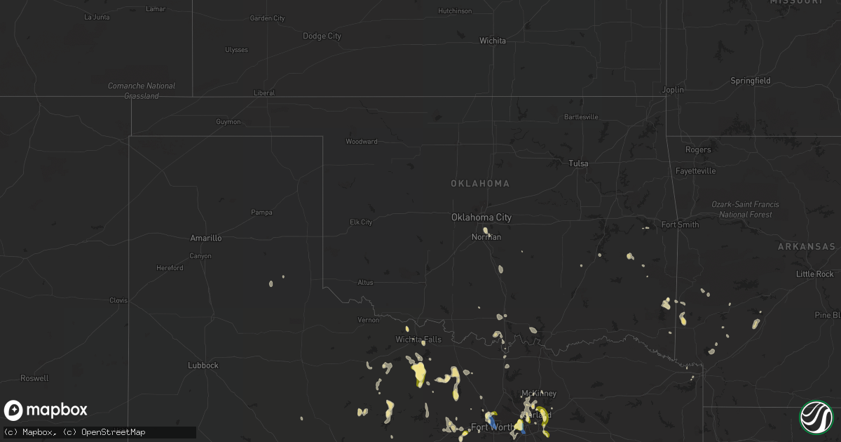
Hail Map in Oklahoma on September 4, 2022
Get this storm
September 4 map
$229
one time, instant access
Download today. No call, no setup
Keep the $229
Bought the map and want the full workflow? Apply the entire $229 to a subscription within 7 days. None of it is wasted.
Every map, not just this one
This buys you this map. Subscription and you get every map we run, in the markets you choose from a few cities to whole states to nationwide. Plus real-time alerts the moment a storm fires.
Contact data
Name, contact info, occupancy, even credit band for addresses in the footprint. You go from where it hit to who to call.
Become the source they trust
Unlimited branding weather history reports on demand. You already have the documented answer ready for the property owner, and you are the one who showed up with it.
Property data and RoofTrace estimates
Pull up any address you have got, its value and the exact code rules for that jurisdiction, straight from One Click Code. Then RoofTrace estimates the squares, pitch, and roof value, priced the way you price.
Storm reports in Oklahoma
Oklahoma
| Date | Description |
|---|---|
| 09/04/20227:13 AM CDT | A local report indicates 58 MPH wind near 4 SE MOORE |
| 09/04/20227:11 AM CDT | A local report indicates 60 MPH wind near 4 ESE MOORE |
| 09/04/20221:56 AM CDT | At 655 AM CDT, a severe thunderstorm was located over southwestern Oklahoma City, or just north of Moore, moving southeast at 20 mph. HAZARD...60 mph wind gusts and quarter size hail. SOURCE...Radar indicated. IMPACT...Hail damage to vehicles is expected. Expect wind damage to roofs, siding, and trees. Locations impacted include... Southern Oklahoma City, Norman, Moore, Del City and Valley Brook. |
| 09/04/20221:23 AM CDT | At 621 AM CDT, severe thunderstorms were located along a line extending from near the I-35 and Kilpatrick Turnpike interchange in north Oklahoma City to near Nichols Hills, moving southeast at 25 mph. HAZARD...60 mph wind gusts and quarter size hail. SOURCE...Radar indicated. IMPACT...Hail damage to vehicles is expected. Expect wind damage to roofs, siding, and trees. Locations impacted include... Oklahoma City, Edmond, Midwest City, Del City, Choctaw, Warr Acres, The Village, Harrah, Spencer, Nichols Hills, Jones, Nicoma Park, Valley Brook, Tinker Air Force Base, Newalla, Forest Park, Lake Aluma and Smith Village. |
| 09/03/202211:40 PM CDT | At 440 PM CDT, a severe thunderstorm was located 5 miles northeast of Krebs, moving southeast at 10 mph. HAZARD...60 mph wind gusts and quarter size hail. SOURCE...Radar indicated. IMPACT...Hail damage to vehicles is expected. Expect wind damage to roofs, siding, and trees. Locations in or near the path include... Krebs... Alderson... Haileyville... Dow... Bache... |
| 09/03/202210:36 PM CDT | At 335 PM CDT, a severe thunderstorm was located 6 miles west of Red Oak, moving southeast at 10 mph. HAZARD...60 mph wind gusts and nickel size hail. SOURCE...Radar indicated. IMPACT...Expect damage to roofs, siding, and trees. Locations in or near the path include... Wilburton... Red Oak... Bengal... Panola... |
All States Impacted by Hail Map on September 4, 2022
Cities Impacted by Hail Map on September 4, 2022
- Eagletown, OK
- Rugby, ND
- Castaic, CA
- Burneyville, OK
- Marietta, OK
- Overbrook, OK
- Mena, AR
- Towner, ND
- Thackerville, OK
- Wichita Falls, TX
- Riesel, TX
- Healdton, OK
- Rockwall, TX
- Sachse, TX
- Wylie, TX
- Rowlett, TX
- Garland, TX
- Weatherford, TX
- Jacksboro, TX
- Windthorst, TX
- Olney, TX
- Henrietta, TX
- Lakeview, TX
- Fort Worth, TX
- Haslet, TX
- Bowie, TX
- Breckenridge, TX
- Woodson, TX
- Graham, TX
- Asher, OK
- Wister, OK
- Granbury, TX
- Cleburne, TX
- Lorena, TX
- Waco, TX
- Arkadelphia, AR
- Okolona, AR
- Seymour, TX
- Iowa Park, TX
- Gainesville, TX
- Texarkana, TX
- Azle, TX
- Springtown, TX
- Throckmorton, TX
- Albany, TX
- Fulton, AR
- Saratoga, AR
- Loving, TX
- Cisco, TX
- Eastland, TX
- Irving, TX
- Cedar Hill, TX
- Grand Prairie, TX
- Dallas, TX
- Teague, TX
- Mcalester, OK
- Madill, OK
- Kingston, OK
- Rhome, TX
- Decatur, TX
- Royse City, TX
- Rotan, TX
- Groesbeck, TX
- Athens, TX
- Chico, TX
- Sunset, TX
- Grandview, TX
- Watson, OK
- Kerens, TX
- Larue, TX
- Montalba, TX
- Palestine, TX
- Chilton, TX
- Richardson, TX
- Allen, TX
- Plano, TX
- Godley, TX
- Red Oak, OK
- Memphis, TX
- Frankston, TX
- Burnet, TX
- Millsap, TX
- Graford, TX
- Bryson, TX
- Canyon Country, CA
- De Queen, AR
- Gillham, AR
- Grannis, AR
- Frisco, TX
- Scotland, TX
- Dublin, TX
- Mart, TX
- Vandervoort, AR
- Cove, AR
- Santa Clarita, CA
- Mineral Wells, TX
- Aledo, TX
- Mesquite, TX
- Venus, TX
- Ardmore, OK
- Norman, OK
- Nashville, AR
- Valley View, TX
- Caddo Gap, AR
- Oklahoma City, OK
- Bridgeport, TX
- Mckinney, TX
- Forney, TX
- Sunnyvale, TX
- Holliday, TX
- Bullhead City, AZ
- Golden Valley, AZ
- Newcastle, TX
- Lipan, TX
- Archer City, TX
- Bismarck, AR
- Bullard, TX
- Fairfield, TX
- Streetman, TX
- Westhope, ND
- Seagoville, TX
- McCaskill, AR
- Lone Grove, OK
- Carrollton, TX
- Addison, TX
- The Colony, TX
- Crandall, TX
- Malakoff, TX
- Princeton, TX
- Keota, OK
- Talihina, OK
- Woodway, TX
- Hooks, TX
- Pauls Valley, OK
- Paoli, OK
- Mineral Springs, AR
- Ozan, AR
- Columbus, AR
- Mingus, TX
- Ranger, TX
- Tennessee Colony, TX
- Keller, TX
- Youngstown, OH
- Kopperl, TX
- Morgan, TX


