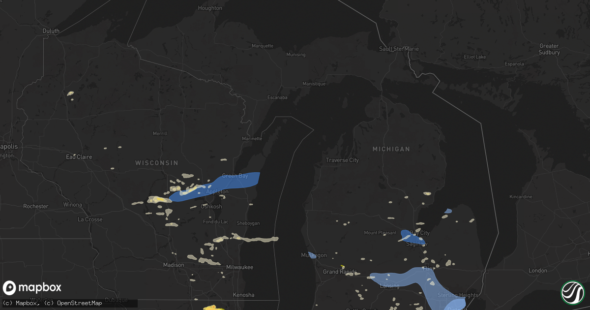
Hail Map in Michigan on August 27, 2024
Get this storm
August 27 map
$229
one time, instant access
Download today. No call, no setup
Keep the $229
Bought the map and want the full workflow? Apply the entire $229 to a subscription within 7 days. None of it is wasted.
Every map, not just this one
This buys you this map. Subscription and you get every map we run, in the markets you choose from a few cities to whole states to nationwide. Plus real-time alerts the moment a storm fires.
Contact data
Name, contact info, occupancy, even credit band for addresses in the footprint. You go from where it hit to who to call.
Become the source they trust
Unlimited branding weather history reports on demand. You already have the documented answer ready for the property owner, and you are the one who showed up with it.
Property data and RoofTrace estimates
Pull up any address you have got, its value and the exact code rules for that jurisdiction, straight from One Click Code. Then RoofTrace estimates the squares, pitch, and roof value, priced the way you price.
Storm reports in Michigan
Michigan
| Date | Description |
|---|---|
| 08/27/20245:33 PM CDT | Multiple trees down around the area |
| 08/27/20245:20 PM CDT | Numerous trees down across the county... Especially north of the city of monroe. |
| 08/27/20245:11 PM CDT | A local report indicates 75 MPH wind near 1 E Roseville |
| 08/27/20245:09 PM CDT | Multiple trees down |
| 08/27/20245:05 PM CDT | Central dispatch reports a few trees and powerlines downed across the county. |
| 08/27/20245:04 PM CDT | Large tree uprooted and fell across the road near cadillac and forest. |
| 08/27/20245:00 PM CDT | Emergency management reports significant widespread tree damage in a trailer park southwest of coldwater. Time estimated via radar. Wind gust of 51 kts was reported at |
| 08/27/20244:57 PM CDT | Large tree uprooted and fell across pine st. |
| 08/27/20244:57 PM CDT | Large tree uprooted and fell across pine st. |
| 08/27/20244:55 PM CDT | A local report indicates 58 MPH wind near Oakland Troy Airport |
| 08/27/20244:55 PM CDT | A local report indicates 76 MPH wind near Detroit Metro Intl Airp |
| 08/27/20244:50 PM CDT | 2 large trees down along southfield dr. |
| 08/27/20244:49 PM CDT | 4 or more powerpoles snapped. Also small tree debris all over the area. |
| 08/27/20244:45 PM CDT | Multiple trees and tree limbs down in and around novi. Reported via twitter/x |
| 08/27/20244:40 PM CDT | Corrects source and time of previous tstm wnd dmg report from 2 ssw coldwater. Emergency management reports significant widespread tree damage in a trailer park southwe |
| 08/27/20244:40 PM CDT | Trees and power lines reported down across many parts of washtenaw county... But especially scio township and ann arbor area. A few trees also landed on houses and cars |
| 08/27/20244:35 PM CDT | A local report indicates 59 MPH wind near 2 W Coldwater |
| 08/27/20244:35 PM CDT | Damage to a trailer park on fillmore rd just south of garfield road. Healthy trees with around a one foot diameter downed... Some fell on cars and trailers and did stru |
| 08/27/20244:33 PM CDT | A local report indicates 66 MPH wind near Oakland County Intl Air |
| 08/27/20244:31 PM CDT | More than a dozen trees down between holly and the oakland/genessee county line. |
| 08/27/20244:25 PM CDT | A local report indicates 67 MPH wind near 4 E White Lake |
| 08/27/20244:25 PM CDT | Numerous trees down all across southern lapeer county. |
| 08/27/20244:20 PM CDT | Large trees downed at kensington park. |
| 08/27/20244:20 PM CDT | Four trees reported blown down. |
| 08/27/20244:15 PM CDT | Trees and tree limbs reported down. |
| 08/27/20244:05 PM CDT | Gust measured at flint bishop airport |
| 08/27/20244:02 PM CDT | Large tree limbs reported down. |
| 08/27/20244:00 PM CDT | At least 4 large trees down in and south of the downtown area. |
| 08/27/20244:00 PM CDT | Tree trunk snapped near base. Power lines pulled down and snapped wooden power pole. |
| 08/27/20243:59 PM CDT | Numerous trees down across livingston county per dispatch. |
| 08/27/20243:48 PM CDT | Large tree down on meridian road near germany rd... Blocking traffic. Estimat |
| 08/27/20243:48 PM CDT | Large tree down on meridian road near germany rd... Blocking traffic. Estimated 2 ft tree diameter. Time estimated via radar. |
| 08/27/20243:45 PM CDT | Multiple trees down. At least one tree damaged a home. |
| 08/27/20243:42 PM CDT | 7 diameter tree limb down near intersection of willard and helmer. Time estimated via radar. |
| 08/27/20243:40 PM CDT | Large tree down across center st near m25 and beck |
| 08/27/20243:40 PM CDT | Reports of 12 inch tree down on a car on campus at michigan state university. Other small |
| 08/27/20243:35 PM CDT | Road signs blown into roadway in the vicinity of martin luther king drive and pleasant grove rd. Time estimated via radar. |
| 08/27/20243:33 PM CDT | Report of healthy 6 inch tree down in the vicinity of s waverly and s lockmore drive. |
| 08/27/20243:30 PM CDT | Report of tree and building damage across east lansing. Time estimated from radar. |
| 08/27/20243:30 PM CDT | Multiple 3+ inch tree limbs down. |
| 08/27/20243:26 PM CDT | Asos station klan lansing. |
| 08/27/20243:20 PM CDT | Delayed report. County dispatch reports downed tree limbs and wires in northeastern ogemaw county... Along with several power outages. Time estimated by radar. |
| 08/27/20243:15 PM CDT | Delayed report. County dispatch reports numerous instances of downed trees... Limbs... And power lines with extensive power outages across the county. Time estimated by |
| 08/27/20243:10 PM CDT | Reports of widespread trees down... As well as a ceiling collapse on a home... In the st. Johns area. Time estimated via radar. |
| 08/27/20243:09 PM CDT | Multiple reports of trees and power lines down along beaver road. |
| 08/27/20243:09 PM CDT | A local report indicates 62 MPH wind near Tri Cities Intl Airport |
| 08/27/20243:06 PM CDT | Large tree uprooted on garfield rd just south of us 10. |
| 08/27/20243:05 PM CDT | One large tree down as well as a large limb over 6 inches in diameter. |
| 08/27/20243:05 PM CDT | Power lines and trees down. |
| 08/27/20243:05 PM CDT | Power lines down due to damaging wind gusts. Heavy rain as well leading to ponding. |
| 08/27/20243:05 PM CDT | Power lines and trees down. |
| 08/27/20243:01 PM CDT | Trees and power lines down due to damaging wind gusts. |
| 08/27/20243:01 PM CDT | Trees and power lines down due to damaging wind gusts. |
| 08/27/20243:01 PM CDT | A local report indicates 62 MPH wind near 3 W Auburn |
| 08/27/20243:01 PM CDT | Trees and power lines down due to damaging wind gusts. |
| 08/27/20243:00 PM CDT | One large rotten trunk snapped. Another tree with large limb snapped. Scattered power outages in the area. |
| 08/27/20243:00 PM CDT | Pea sized hail falling. |
| 08/27/20242:54 PM CDT | Trees down near us 10 business loop and eastman rd. |
| 08/27/20242:50 PM CDT | Aged barn completely blown down/destroyed near lincoln lake and 5-mile rd. Time estimated via radar. |
| 08/27/20242:30 PM CDT | Numerous trees damage around the mount pleasant area. Time estimated via radar. |
| 08/27/20242:29 PM CDT | Quarter-sized hail reported by a trained spotter near intersection of jupiter and coit. Time estimated via radar. |
| 08/27/20242:28 PM CDT | Estimated 60 mph wind gusts associated with thunderstorm. |
| 08/27/20242:25 PM CDT | Scattered trees and power lines down between cedar springs and rockford. |
| 08/27/20242:19 PM CDT | Snapped power lines near intersection of 9-mile and division. Time estimated via radar. |
| 08/27/20242:10 PM CDT | Several trees snapped or uprooted in the farwell area. Numerous power outages in much of clare county. |
| 08/27/20242:00 PM CDT | Pictures of large tree down on several parked cars. Delayed report. Time estimated via radar. |
| 08/27/20242:00 PM CDT | Social media report of large tree branches roughly 6 inches in diameter down on house in mecosta. Time estimated via radar. |
| 08/27/20241:48 PM CDT | Time estimated from radar. Peak wind gust associated with thunderstorm... Measured on south inner muskegon pier. |
| 08/27/20241:41 PM CDT | Half a tree down on a house. |
| 08/27/20241:40 PM CDT | Hwy 115 closed due to large trees over road. Widespread tree damage throughout wexford county. |
| 08/27/20241:40 PM CDT | A few trees or large limbs down in the big rapids area. |
| 08/27/20241:39 PM CDT | Hwy 55 closed briefly due to large trees down over roadways. |
| 08/27/20241:33 PM CDT | Healthy 12 inch trunk snapped. Several power outages in northwest osceola county. |
| 08/27/20241:15 PM CDT | Trees down in the area. Road blocked. |
| 08/27/20241:10 PM CDT | A few fallen trees or large limbs damaging vehicles. |
| 08/27/20241:09 PM CDT | Several trees or large limbs down near big star lake. Some roads blocked. |
| 08/27/202412:54 PM CDT | Delayed report. 12 inch diameter tree downed by thunderstorm winds. Time estimated by radar. |
| 08/27/202412:54 PM CDT | Corrects previous tstm wnd dmg report from 4 n colfax. Social media report of trees down in mason county near ruby creek. Time estimated from radar. |
| 08/27/202412:54 PM CDT | Social media report of trees down in mason county near ruby creek. Time estimated from radar. |
| 08/27/20241:28 AM CDT | Wet mirco-burst downed trees in plymouth. |
| 08/26/20248:40 PM CDT | Trees snapped and uprooted in galien... Mi. Time estimated via radar. |
| 08/26/20248:36 PM CDT | Tree onto home in union pier. Home damaged... But no injuries to any of the occupants. Time estimated via radar. |
| 08/26/20248:36 PM CDT | Numerous large tree limbs and powerlines down. Time estimated via radar. |
| 08/26/20248:35 PM CDT | Numerous large trees and powerlines down. Time estimated via radar. |
| 08/26/20248:35 PM CDT | Large trees down onto homes and several cars in union pier. Photos on facebook. No injuries reported. Time estimated via radar. |
| 08/26/20248:25 PM CDT | Numerous tree limbs and branches down on s basswood rd near three oaks. Time estimated via radar. |
| 08/26/20248:24 PM CDT | Facebook video shows a tree onto a home in three oaks. Home damaged... But no injuries to any of the occupants. Time estimated via radar. |
| 08/26/20248:15 PM CDT | Fire department reports numerous trees down in new buffalo. Time estimated via radar. |
| 08/26/20248:10 PM CDT | Large trees down at a home on marx drive in new buffalo. Time estimated via radar. |
| 08/26/20248:10 PM CDT | Numerous trees down onto roads in chikaming township... Reported by the fire department. Time estimated via radar. |
All States Impacted by Hail Map on August 27, 2024
Cities Impacted by Hail Map on August 27, 2024
- New Auburn, WI
- Cameron, WI
- Chetek, WI
- Bloomer, WI
- Weyerhaeuser, WI
- Eau Claire, WI
- Spooner, WI
- Sarona, WI
- Krakow, WI
- Birchwood, WI
- Stone Lake, WI
- Springbrook, WI
- Stanley, WI
- Thorp, WI
- Owen, WI
- Withee, WI
- Camp Douglas, WI
- Necedah, WI
- Neillsville, WI
- Arkdale, WI
- Nekoosa, WI
- Manitowoc, WI
- Friendship, WI
- Mauston, WI
- Cleveland, WI
- Newton, WI
- Hancock, WI
- Grand Marsh, WI
- Adams, WI
- Endeavor, WI
- Oxford, WI
- Plover, WI
- Westfield, WI
- Bancroft, WI
- Plainfield, WI
- Coloma, WI
- Iola, WI
- Wild Rose, WI
- Montello, WI
- Almond, WI
- Stevens Point, WI
- Amherst, WI
- Waupaca, WI
- Dalton, WI
- Ogdensburg, WI
- Scandinavia, WI
- Pine River, WI
- Berlin, WI
- Redgranite, WI
- Weyauwega, WI
- Winter, WI
- Manawa, WI
- New London, WI
- Wautoma, WI
- Fremont, WI
- Poy Sippi, WI
- Hortonville, WI
- Larsen, WI
- Deforest, WI
- Oshkosh, WI
- Omro, WI
- Shiocton, WI
- Greenville, WI
- Menasha, WI
- Hilbert, WI
- Sherwood, WI
- Sobieski, WI
- Pulaski, WI
- Appleton, WI
- Kaukauna, WI
- Neenah, WI
- Little Chute, WI
- Seymour, WI
- Black Creek, WI
- De Pere, WI
- Oneida, WI
- Waterloo, WI
- Marshall, WI
- Van Dyne, WI
- Fond Du Lac, WI
- Green Bay, WI
- Denmark, WI
- Wrightstown, WI
- Kimberly, WI
- Maribel, WI
- Greenleaf, WI
- Juneau, WI
- New Franken, WI
- Luxemburg, WI
- Kewaunee, WI
- Horicon, WI
- Iron Ridge, WI
- Watertown, WI
- Lowell, WI
- Mayville, WI
- Theresa, WI
- Algoma, WI
- Casco, WI
- Hartford, WI
- West Bend, WI
- Allenton, WI
- Kewaskum, WI
- Johnson Creek, WI
- Rubicon, WI
- Neosho, WI
- Random Lake, WI
- Fredonia, WI
- Adell, WI
- Ixonia, WI
- Oconomowoc, WI
- Fort Atkinson, WI
- Ashippun, WI
- Edgerton, WI
- Milton, WI
- Belgium, WI
- Delafield, WI
- Nashotah, WI
- Hartland, WI
- Pewaukee, WI
- Anderson, TX
- North Prairie, WI
- Mukwonago, WI
- Waukesha, WI
- Iola, TX
- Big Bend, WI
- Bitely, MI
- Montgomery, TX
- Magnolia, TX
- Kanopolis, KS
- Hersey, MI
- Big Rapids, MI
- Paris, MI
- Ellsworth, KS
- Mount Pleasant, MI
- Gladwin, MI
- Beaverton, MI
- Coleman, MI
- Shepherd, MI
- Muskegon, MI
- Alger, MI
- Wheeler, MI
- Merrill, MI
- Freeland, MI
- South Haven, MI
- Sheridan, MI
- Fenwick, MI
- Greenville, MI
- Lowell, MI
- Ada, MI
- Grand Rapids, MI
- Comstock Park, MI
- Saginaw, MI
- Midland, MI
- Hemlock, MI
- El Campo, TX
- Garwood, TX
- Saranac, MI
- Hubbardston, MI
- Hastings, MI
- Middleton, MI
- Carson City, MI
- Kawkawlin, MI
- Bay City, MI
- Linwood, MI
- Portland, MI
- Carrollton, MI
- Cassopolis, MI
- Whittemore, MI
- University Center, MI
- Lincoln, TX
- New Carlisle, IN
- National City, MI
- Omer, MI
- Twining, MI
- Marcellus, MI
- Woodland, MI
- Dewitt, MI
- Saint Johns, MI
- Nashville, MI
- Westphalia, MI
- Ionia, MI
- Lyons, MI
- Pewamo, MI
- Eagle, MI
- Fowler, MI
- Sunfield, MI
- Grand Ledge, MI
- Bancroft, MI
- Bath, MI
- Lansing, MI
- East Lansing, MI
- Morrice, MI
- Owosso, MI
- Perry, MI
- Laingsburg, MI
- Okemos, MI
- Williamston, MI
- Haslett, MI
- Auburn, MI
- Lennon, MI
- Swartz Creek, MI
- Flushing, MI
- Durand, MI
- Corunna, MI
- Vernon, MI
- Oakley, MI
- Tawas City, MI
- Turner, MI
- Bennington, KS
- Frankenmuth, MI
- Dowling, MI
- Mishawaka, IN
- South Bend, IN
- Granger, IN
- Pigeon, MI
- Elkton, MI
- Caseville, MI
- Kinde, MI
- Gaines, MI
- Webberville, MI
- Flint, MI
- Byron, MI
- Fowlerville, MI
- Bellevue, MI
- Three Rivers, MI
- Clio, MI
- Montrose, MI
- Mount Morris, MI
- Bad Axe, MI
- Leonidas, MI
- Colon, MI
- Bay Port, MI
- Abilene, KS
- Harrisonville, MO
- Vandalia, MI
- Athens, MI
- Birch Run, MI
- Mason, MI
- Burton, MI
- Linden, MI
- Grand Blanc, MI
- Fenton, MI
- Holly, MI
- Marshall, MI
- Rives Junction, MI
- Davison, MI
- Albion, MI
- Parma, MI
- Leslie, MI
- Harbor Beach, MI
- Pleasant Hill, MO
- Garden City, MO
- Constantine, MI
- Genesee, MI
- Otisville, MI
- West Point, TX
- Jones, MI
- Centreville, MI
- Burr Oak, MI
- Elkhart, IN
- White Lake, MI
- Davisburg, MI
- Highland, MI
- Clarkston, MI
- Ortonville, MI
- Waterford, MI
- Goodrich, MI
- Bronson, MI
- White Pigeon, MI
- Lapeer, MI
- Fostoria, MI
- North Branch, MI
- Lucas, KS
- Ruth, MI
- Sherwood, MI
- Homer, MI
- Middlebury, IN
- Bristol, IN
- Jackson, MI
- Minneapolis, KS
- Goshen, IN
- Mission, TX
- Edinburg, TX
- Pleasant Lake, MI
- La Grange, TX
- Sturgis, MI
- Coldwater, MI
- Pontiac, MI
- Luray, KS
- Litchfield, MI
- Dexter, MI
- Chelsea, MI
- Ann Arbor, MI
- Enterprise, KS
- Howe, IN
- Shelbina, MO
- Clay Center, KS
- East Lynne, MO
- Imlay City, MI
- Attica, MI
- Thorndale, TX
- Thrall, TX
- Beloit, WI
- Shipshewana, IN
- Quincy, MI
- Clarklake, MI
- Jerome, MI
- Horton, MI
- Hanover, MI
- Concordia, KS
- Dunnellon, FL
- Monroe City, MO
- Russell, KS
- Allen, MI
- Bloomfield Hills, MI
- Keego Harbor, MI
- Auburn Hills, MI
- Sterling Heights, MI
- Troy, MI
- West Bloomfield, MI
- Rochester, MI
- Royal Oak, MI
- Clawson, MI
- Madison Heights, MI
- Birmingham, MI
- Franklin, MI
- Commerce Township, MI
- Reading, MI
- Garden Prairie, IL
- Harvard, IL
- Macon, MO
- Anabel, MO
- Livonia, MO
- Longview, TX
- Chapman, KS
- Clarence, MO
- Lentner, MO
- Madison, MO
- Palmyra, MO
- Clinton, WI
- Manchester, MI
- Jonesville, MI
- South Beloit, IL
- Cement City, MI
- Orland, IN
- Marengo, IL
- Woodstock, IL
- Harper Woods, MI
- Grosse Pointe, MI
- Hazel Park, MI
- Center Line, MI
- Detroit, MI
- Warren, MI
- Eastpointe, MI
- Roseville, MI
- Saint Clair Shores, MI
- Bucyrus, KS
- Overland Park, KS
- Glenwood, MO
- Queen City, MO
- Junction City, KS
- Waldo, KS
- Chilton, TX
- Lott, TX
- Hannibal, MO
- Olathe, KS
- Paris, MO
- Santa Fe, MO
- Brooklyn, MI
- Linwood, KS
- Dwight, KS
- Belton, MO
- Fraser, MI
- Clinton Township, MI
- Harrison Township, MI
- Eddy, TX
- Holden, MO
- Stilwell, KS
- Coatsville, MO
- Kent City, MI
- Elmer, MO
- Ethel, MO
- Alta Vista, KS
- Freeman, MO
- De Soto, KS
- Casnovia, MI
- Crystal Lake, IL
- Greentop, MO
- Creighton, MO
- Rutledge, MO
- Gorin, MO
- Lancaster, MO
- Huntley, IL
- Mchenry, IL
- Hebron, IL
- Union, IL
- Tonganoxie, KS
- Rio Grande City, TX
- Morganville, KS
- Wauseon, OH
- Bonner Springs, KS
- White City, KS
- Peculiar, MO
- Cary, IL
- Barrington, IL
- Island Lake, IL
- Wauconda, IL
- Kansas City, MO
- Kirksville, MO
- Atlanta, MO
- La Plata, MO
- Blairstown, MO
- Lenexa, KS
- Arbela, MO
- Downing, MO
- Luray, MO
- Beloit, KS
- Center, MO
- Cleveland, MO
- Belleville, KS
- Perry, MO
- Lawrence, KS
- Holliday, MO
- Memphis, MO
- Excello, MO
- Mundelein, IL
- Lake Zurich, IL
- Jamestown, KS
- Manhattan, KS
- Bluff Dale, TX
- Tolar, TX
- Scandia, KS
- Kansas City, KS
- Jacksonville, MO
- Drexel, MO
- Louisburg, KS
- Del Rio, TX
- Jasper, MI
- Delta, OH
- Round Lake, IL
- Grayslake, IL
- Fox River Grove, IL
- Vernon Hills, IL
- Libertyville, IL
- Lincolnshire, IL
- Buffalo Grove, IL
- Lake Forest, IL
- Palatine, IL
- Arlington Heights, IL
- Wheeling, IL
- Deerfield, IL
- Edina, MO
- Baring, MO
- Liberty Center, OH
- Prairie Village, KS
- Hurdland, MO
- Gardner, KS
- Novelty, MO
- Swanton, OH
- Donnellson, IA
- Kahoka, MO
- Highwood, IL
- Highland Park, IL
- Northbrook, IL
- Glencoe, IL
- Wilmette, IL
- Glenview, IL
- Prospect Heights, IL
- Winnetka, IL
- Kenilworth, IL
- Mount Prospect, IL
- Skokie, IL
- Morton Grove, IL
- Golf, IL
- Chicago, IL
- Evanston, IL
- Riverside, MO
- Lyons, OH
- Knox City, MO
- Westmoreland, KS
- Frankfort, KS
- Spring Hill, KS
- Hallsville, MO
- Topeka, KS
- Sand Creek, MI
- Berkey, OH
- Archbold, OH
- Sylvania, OH
- Holland, OH
- Toledo, OH
- Blissfield, MI
- Metamora, OH
- Fayette, OH
- Grand Rapids, OH
- Waterville, OH
- Rossford, OH
- Neapolis, OH
- Maumee, OH
- Napoleon, OH
- Monclova, OH
- Perrysburg, OH
- Whitehouse, OH
- Dunbridge, OH
- Bowling Green, OH
- Custar, OH
- Pemberville, OH
- Luckey, OH
- Haskins, OH
- Weston, OH
- McClure, OH
- Tontogany, OH
- Portage, OH
- North Baltimore, OH
- Milton Center, OH
- Rudolph, OH
- Van Buren, OH
- Cygnet, OH
- Wayne, OH
- Bradner, OH
- Jerry City, OH
- West Millgrove, OH
- Fostoria, OH
- Bloomdale, OH
- Kansas, OH
- Helena, OH
- Risingsun, OH
- Gibsonburg, OH
- Findlay, OH
- Alvada, OH
- Arcadia, OH
- Tiffin, OH
- New Riegel, OH
- Bascom, OH
- Farmington, IA
- Callao, MO
- Somerset, TX
- Von Ormy, TX
- Perry, KS
- Rolling Meadows, IL
- Schaumburg, IL
- San Antonio, TX
- Oskaloosa, KS
- Valley Falls, KS
- Eudora, KS
- Brashear, MO
- Novinger, MO
- Oneida, IL
- Platte City, MO
- Smithville, MO
- Edgerton, MO
- Weston, MO
- Camden Point, MO
- Vanlue, OH
- Carey, OH
- Mount Blanchard, OH
- Upper Sandusky, OH
- McCutchenville, OH
- Sycamore, OH
- Cambridge, IL
- Lynn Center, IL
- Dallas City, IL
- Edgerton, KS
- Des Plaines, IL
- Elk Grove Village, IL
- New Cambria, MO
- West Chicago, IL
- Carol Stream, IL
- Altona, IL
- Roselle, IL
- Bloomingdale, IL
- Medinah, IL
- Grandview, MO
- Wharton, OH
- Harpster, OH
- Nevada, OH
- Morral, OH
- Bucyrus, OH
- Niles, IL
- Glen Ellyn, IL
- Glendale Heights, IL
- Floresville, TX
- Adkins, TX
- La Vernia, TX
- Itasca, IL
- Lombard, IL
- Addison, IL
- Woodhull, IL
- La Fayette, IL
- Toulon, IL
- Victoria, IL
- Ozawkie, KS
- Lytle, TX
- Atascosa, TX
- New Boston, MO
- Green Castle, MO
- Bevier, MO
- Meriden, KS
- Park Ridge, IL
- Denison, KS
- Centralia, MO
- Hoyt, KS
- Solomon, KS
- Aurora, KS
- Randolph, KS
- Bonaparte, IA
- Warsaw, IL
- Green City, MO
- Big Wells, TX
- Clifton, KS
- Villa Park, IL
- Bensenville, IL
- Elmhurst, IL
- Sturgeon, MO
- Trimble, MO
- Gower, MO
- Agency, MO
- Wheaton, IL
- Wood Dale, IL
- Melrose Park, IL
- Downers Grove, IL
- Oak Brook, IL
- Berkeley, IL
- Broadview, IL
- Hillside, IL
- Bellwood, IL
- Westchester, IL
- La Grange Park, IL
- Hines, IL
- Riverside, IL
- Stone Park, IL
- Forest Park, IL
- Maywood, IL
- Berwyn, IL
- Western Springs, IL
- Clarendon Hills, IL
- Hinsdale, IL
- Brookfield, IL
- Westmont, IL
- Marion, OH
- Caledonia, OH
- Galva, IL
- Mayetta, KS
- Aurora, IL
- Naperville, IL
- Winigan, MO
- Wyoming, IL
- Devine, TX
- La Coste, TX
- Castroville, TX
- Batavia, IL
- Hamilton, IL
- Drakesville, IA
- Nauvoo, IL
- Cummings, KS
- Montrose, IA
- Lomax, IL
- Milan, MO
- Elmendorf, TX
- Danville, IA
- Lyons, IL
- La Grange, IL
- Schiller Park, IL
- Franklin Park, IL
- Holton, KS
- Fort Madison, IA
- Wever, IA
- Bloomfield, IA
- Pollock, MO
- Lucerne, MO
- Lisle, IL
- Stewartsville, MO
- Niota, IL
- Browning, MO
- Bradford, IL
- Carthage, IL
- Warrenville, IL
- Cincinnati, IA
- Centerville, IA
- River Grove, IL
- Harwood Heights, IL
- Effingham, KS
- Keytesville, MO
- Salisbury, MO
- Lakeside, MI
- Three Oaks, MI
- New Buffalo, MI
- Union Pier, MI
- West Point, IA
- Thompson, MO
- Utica, IL
- Darien, IL
- Willowbrook, IL
- Unionville, MO
- Burlington, IA
- Ottawa, IL
- Saint Joseph, MO
- Bridgeview, IL
- Easton, MO
- La Porte, IN
- Gary, IN
- Highland, IN
- Griffith, IN
- Winfield, IL
- Woodridge, IL
- Henderson, IL
- Wataga, IL
- Everest, KS
- Spring Valley, IL
- Plattsburg, MO
- Manhattan, IL
- Raritan, IL
- La Harpe, IL
- Lemont, IL
- Robinson, KS
- Bolingbrook, IL
- Blandinsville, IL
- Henry, IL
- Muscotah, KS
- Osborn, MO
- Hennepin, IL
- Granville, IL
- Galesburg, IL
- Putnam, IL
- Powersville, MO
- Palos Park, IL
- Moulton, IA
- Galien, MI
- Willow Springs, IL
- Earlville, IL
- Clarksdale, MO
- Rolling Prairie, IN
- Valparaiso, IN
- Crown Point, IN
- Smithshire, IL
- Media, IL
- Roseville, IL
- Frankfort, IL
- Sparland, IL
- Sperry, IA
- Yarmouth, IA
- West Burlington, IA
- Marseilles, IL
- New Lenox, IL
- Romeoville, IL
- Clifton Hill, MO
- Hebron, IN
- Exline, IA
- Monee, IL
- Ionia, MO
- Green Ridge, MO
- Lincoln, MO
- Cameron, MO
- University Park, IL
- Speer, IL
- Laura, IL
- Morris, IL
- Buchanan, MI
- Niles, MI
- De Witt, MO
- Carrollton, MO
- Mokena, IL
- Bosworth, MO
- Hale, MO
- Tina, MO
- Bogard, MO
- Lockport, IL
- Gilson, IL
- Knoxville, IL
- McNabb, IL
- Magnolia, IL
- Lacon, IL
- Washburn, IL
- Bremen, IN
- Osceola, IN
- Princeville, IL
- Oglesby, IL
- Standard, IL
- Peru, IL
- Cedar Point, IL
- Chillicothe, MO
- Dawn, MO
- Varna, IL
- Notre Dame, IN
- Lostant, IL
- Berwick, IL
- Sciota, IL
- Mark, IL
- Streator, IL
- Tinley Park, IL
- Verona, IL
- Tonica, IL
- Wenona, IL
- Williamsfield, IL
- Dahinda, IL
- Breckenridge, MO
- Gallatin, MO
- Lowell, IN
- Seneca, IL
- Utica, MO
- Nappanee, IN
- Wakarusa, IN
- Seymour, IA
- Coal City, IL
- Sawyer, MI
- Union Mills, IN
- Hamlet, IN
- Chesterton, IN
- Harbert, MI
- Westville, IN
- Portage, IN
- Michigan City, IN
- Mill Creek, IN
- Plymouth, IN
- Walkerton, IN
- Beverly Shores, IN
- North Liberty, IN
- Lakeville, IN
- Elmwood, IL
- Mazon, IL
- Wilmington, IL
- Grand Ridge, IL
- Channahon, IL
- Minooka, IL
- East Galesburg, IL
- London Mills, IL
- Maquon, IL
- Avon, IL
- Brimfield, IL
- Millersburg, IN
- Syracuse, IN
- New Paris, IN
- Leonore, IL
- Ransom, IL
- Dana, IL
- Canton, IL
- Farmington, IL
- Fairview, IL
- Cornell, IL
- Mooresville, MO
- Ligonier, IN
- Topeka, IN
- Hamilton, MO
- Jameson, MO
- Momence, IL
- Yates City, IL
- Norris, IL
- Bonfield, IL
- Reddick, IL
- Gardner, IL
- Essex, IL
- Glasford, IL
- Kankakee, IL
- Geneseo, IL
- Ancona, IL
- Minonk, IL
- Hanna City, IL
- Pembroke Township, IL
- Flanagan, IL
- Jamesport, MO
- Lock Springs, MO
- Long Point, IL
- Papineau, IL
- Beaverville, IL
- Martinton, IL
- Saint Anne, IL
- Manito, IL
- Kingston Mines, IL
- Mapleton, IL
- Clifton, IL
- Albion, IN
- Pinckney, MI
- Howell, MI
- Tremont, IL
- Groveland, IL
- Morton, IL
- Pekin, IL
- Ashkum, IL
- Mackinaw, IL
- Danforth, IL
- Cuba, IL
- Gregory, MI
- Gilman, IL
- Towanda, IL
- Hudson, IL
- Saline, MI
- Gridley, IL
- Lexington, IL
- Chenoa, IL
- Wonder Lake, IL
- Middletown, IA
- Stronghurst, IL
- Saint Augustine, IL
- Oakville, IA
- Keithsburg, IL
- Carman, IL
- Mediapolis, IA
- Gladstone, IL
- Cameron, IL
- Abingdon, IL
- Oquawka, IL
- Biggsville, IL
- Monmouth, IL
- New London, IA
- Denmark, IA
- Little York, IL
- Seaton, IL
- Kirkwood, IL
- Colfax, IL
- Serena, IL
- Southfield, MI
- Berkley, MI
- Farmer City, IL
- Graymont, IL
- Weldon, IL
- Bellflower, IL
- Pontiac, IL
- Basco, IL
- Edelstein, IL
- Grass Lake, MI
- Monticello, IL
- North Aurora, IL
- Peoria, IL
- Creve Coeur, IL
- East Peoria, IL
- De Land, IL
- Mansfield, IL
- Sadorus, IL
- New London, MO
- Ivesdale, IL
- Baylis, IL
- Chambersburg, IL
- Clarksville, MO
- Edwardsville, IL
- Marine, IL
- Warrenton, MO
- Troy, MO
- Hawk Point, MO
- Old Monroe, MO
- Winfield, MO
- Moscow Mills, MO
- Shelbyville, MO
- West Alton, MO
- Du Quoin, IL
- Trivoli, IL
- Hopedale, IL
- Chatham, IL
- Springfield, IL
- Alton, IL
- Tuscola, IL
- Pesotum, IL
- Benton, IL
- Bethalto, IL
- Whittington, IL
- Saint Louis, MO
- Ewing, IL
- Columbia, IL
- Leonard, MO
- Tamaroa, IL
- Grosse Ile, MI
- Livonia, MI
- Oak Park, MI
- Farmington, MI
- Highland Park, MI
- Walled Lake, MI
- Hamtramck, MI
- Milford, MI
- Romulus, MI
- Taylor, MI
- Pleasant Ridge, MI
- Dearborn, MI
- South Lyon, MI
- Huntington Woods, MI
- Northville, MI
- Westland, MI
- Dearborn Heights, MI
- New Hudson, MI
- Redford, MI
- Ecorse, MI
- Novi, MI
- Plymouth, MI
- Allen Park, MI
- Melvindale, MI
- Southgate, MI
- Hartland, MI
- Inkster, MI
- Trenton, MI
- Wixom, MI
- Riverview, MI
- Ferndale, MI
- Garden City, MI
- Lincoln Park, MI
- Wyandotte, MI
- River Rouge, MI
- Belleville, MI
- Wayne, MI
- Canton, MI
- Ypsilanti, MI
- Brighton, MI
- New Boston, MI
- Flat Rock, MI
- Rockwood, MI
- South Rockwood, MI
- Carleton, MI


