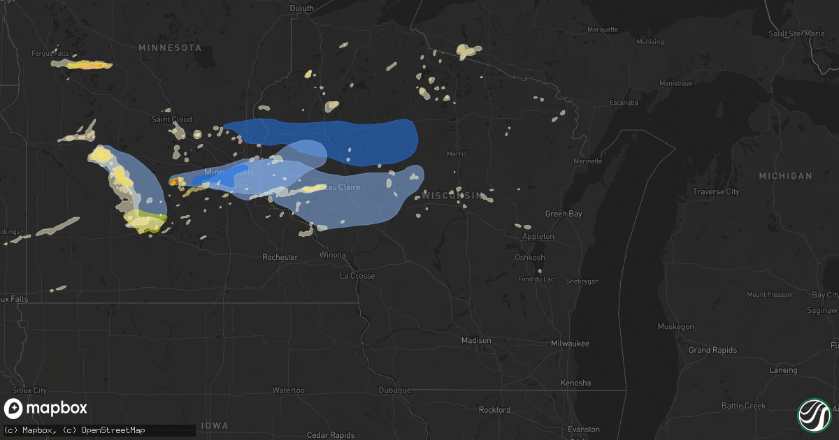
Hail Map in Wisconsin on August 26, 2024
Get this storm
August 26 map
$229
one time, instant access
Download today. No call, no setup
Keep the $229
Bought the map and want the full workflow? Apply the entire $229 to a subscription within 7 days. None of it is wasted.
Every map, not just this one
This buys you this map. Subscription and you get every map we run, in the markets you choose from a few cities to whole states to nationwide. Plus real-time alerts the moment a storm fires.
Contact data
Name, contact info, occupancy, even credit band for addresses in the footprint. You go from where it hit to who to call.
Become the source they trust
Unlimited branding weather history reports on demand. You already have the documented answer ready for the property owner, and you are the one who showed up with it.
Property data and RoofTrace estimates
Pull up any address you have got, its value and the exact code rules for that jurisdiction, straight from One Click Code. Then RoofTrace estimates the squares, pitch, and roof value, priced the way you price.
Storm reports in Wisconsin
Wisconsin
| Date | Description |
|---|---|
| 08/26/20246:28 AM CDT | 6 inch diameter tree down and a larger tree snapped at the base. |
| 08/26/20246:27 AM CDT | 8 to 9 inch diameter trees snapped. |
| 08/26/20246:18 AM CDT | 2ft diameter trees uprooted. |
| 08/26/20245:54 AM CDT | Large tree snapped at trunk. Video sent via twitter. |
| 08/26/20241:18 AM CDT | Trees down in the town of hutchins. Time estimated by radar. |
| 08/26/20241:07 AM CDT | Report from mping: 3-inch tree limbs broken; power poles broken. |
| 08/26/20241:04 AM CDT | Report from mping: 3-inch tree limbs broken; power poles broken. |
| 08/26/202412:54 AM CDT | Report from mping: 1-inch tree limbs broken; shingles blown off. |
| 08/26/202412:42 AM CDT | Power lines down on kellogg street. Time estimated by radar. |
| 08/25/202411:50 PM CDT | Corrects previous tstm wnd dmg report from 2 wsw mattoon. Trees down in the town of hutchins. Time estimated by radar. |
| 08/25/202411:44 PM CDT | Trees down on highway 45 in conover. Time estimated by radar. |
| 08/25/202411:36 PM CDT | One tree down on a powerline in aniwa. |
| 08/25/202411:31 PM CDT | Trees down on highway70 in st. Germain. Time estimated by radarw. |
| 08/25/202411:30 PM CDT | Report from mping: 3-inch tree limbs broken; power poles broken. |
| 08/25/202411:17 PM CDT | Trees down on highway w in winchester. Time estimated by radar. |
| 08/25/202410:44 PM CDT | County sheriff dispatch reports multiple trees down. Time estimated based on radar. |
| 08/25/202410:41 PM CDT | County sheriff dispatch reports multiple trees down. Time estimated based on radar. |
| 08/25/202410:40 PM CDT | Trees down in spencer. Time estimated by radar. |
| 08/25/202410:37 PM CDT | Reports of a few trees down. Time estimated by radar and when the peak gust occurred at the marshfield airport. |
| 08/25/202410:30 PM CDT | Storm knocked down trees blocking county highway w west of phillips and storms road in price county. Transformer on fire on hwy w site. At approximately 2230 hrs. |
| 08/25/202410:30 PM CDT | Storm wind downed trees blocking county highway w west of phillips and storms road. Transformer on fire on hwy w site. At approximately 2230 hrs. |
| 08/25/202410:07 PM CDT | Mesonet station tt569 ganoe hill. |
| 08/25/20249:39 PM CDT | County sheriff dispatch reported multiple downed powerlines on the east side of sand lake along county highway f. |
| 08/25/20249:32 PM CDT | Asos station keau eau claire ap. |
| 08/25/20249:30 PM CDT | Reports of multiple trees down in cornell. |
| 08/25/20249:29 PM CDT | County sheriff dispatch reported a downed powerline. |
| 08/25/20249:28 PM CDT | Several trees reported down and on a local county road on the northwest side of lake chetac. Time estimated based on radar. |
| 08/25/20249:22 PM CDT | Wind broke window on west side of home. |
| 08/25/20249:22 PM CDT | Trees down that fell on power lines. |
| 08/25/20249:09 PM CDT | County sheriff dispatch reported a tree downed. |
| 08/25/20249:04 PM CDT | Reports of numerous tree branches down throughout dunn county. Time estimated from radar. |
| 08/25/20249:00 PM CDT | Multiple trees and power lines down. Time estimated from radar. |
| 08/25/20249:00 PM CDT | Ten inch maple branch down with minor roof damage to house. Time is estimated. |
| 08/25/20248:58 PM CDT | Delayed report of multiple large trees downed blocking roads. Time estimated from radar. |
| 08/25/20248:25 PM CDT | Power has been out for an hour as of 943 pm. 2.92 inches of rain in cocorahs gage. Tree branches up to 1.5 inches in diameter broken. Report time estimated for tree dam |
| 08/25/20247:41 PM CDT | A local report indicates 1.25 inch wind near 4 E Webb Lake |
All States Impacted by Hail Map on August 26, 2024
Cities Impacted by Hail Map on August 26, 2024
- Riverton, WY
- Lander, WY
- Jeffrey City, WY
- Shoshoni, WY
- Lysite, WY
- Antrim, NH
- Hancock, NH
- Plympton, MA
- Bristol, NH
- New Hampton, NH
- Middleboro, MA
- Carver, MA
- Halifax, MA
- Buzzards Bay, MA
- Olmstedville, NY
- Plymouth, MA
- East Wareham, MA
- North Creek, NY
- South Dennis, MA
- West Dennis, MA
- Dennis Port, MA
- Harwich Port, MA
- Onset, MA
- Wareham, MA
- Hubbardston, MA
- Barre, MA
- Rutland, MA
- Princeton, MA
- Bakers Mills, NY
- Granville, MA
- Blandford, MA
- Loudon, NH
- Concord, NH
- Marion, MA
- Rochester, MA
- Wevertown, NY
- Fergus Falls, MN
- Minerva, NY
- Dalton, MN
- Mattapoisett, MA
- Henniker, NH
- Johnsburg, NY
- Cummington, MA
- Charlemont, MA
- Hillsborough, NH
- Oakham, MA
- Acushnet, MA
- Harwich, MA
- Petersham, MA
- Bradford, NH
- South Barre, MA
- Plainfield, MA
- Cataumet, MA
- North Falmouth, MA
- East Hartland, CT
- West Granby, CT
- North Granby, CT
- Barkhamsted, CT
- East Falmouth, MA
- Mashpee, MA
- Fairhaven, MA
- Fall River, MA
- Westport, MA
- New Braintree, MA
- Gilbertville, MA
- Hardwick, MA
- Worthington, MA
- New Bedford, MA
- Pocasset, MA
- Battle Lake, MN
- Glenrock, WY
- Riverside, RI
- Barrington, RI
- Warren, RI
- North Dartmouth, MA
- Falmouth, MA
- South Dartmouth, MA
- Ashby, MN
- Farmington, CT
- Avon, CT
- Unionville, CT
- Canton, CT
- West Simsbury, CT
- Southington, CT
- Vineyard Haven, MA
- Tiverton, RI
- Bristol, RI
- Wilbraham, MA
- Hampden, MA
- Evansville, MN
- Vining, MN
- Clitherall, MN
- Belchertown, MA
- Ashford, CT
- Willington, CT
- Berlin, CT
- Meriden, CT
- West Kingston, RI
- Hinsdale, MA
- Hill, NH
- East Greenwich, RI
- North Kingstown, RI
- Parkers Prairie, MN
- Brandon, MN
- Stafford Springs, CT
- Middlefield, CT
- Wallingford, CT
- Edgartown, MA
- Becket, MA
- Plainville, CT
- New Britain, CT
- Warwick, RI
- King George, VA
- Fredericksburg, VA
- Ludlow, MA
- Three Rivers, MA
- Oak Bluffs, MA
- Ashuelot, NH
- Hinsdale, NH
- Winchester, NH
- Northfield, MA
- Vernon, VT
- Durham, CT
- Northford, CT
- Guilford, CT
- Exeter, RI
- Pomfret Center, CT
- Woodstock, CT
- Woodstock Valley, CT
- Eastford, CT
- Monson, MA
- Palmer, MA
- Dover, NH
- Rollinsford, NH
- Port Royal, VA
- Rappahannock Academy, VA
- Wyoming, RI
- Carolina, RI
- Woodford, VA
- Egg Harbor City, NJ
- West Greenwich, RI
- Saunderstown, RI
- North Branford, CT
- Shannock, RI
- Kenyon, RI
- Charlestown, RI
- Somersworth, NH
- Bowling Green, VA
- Hope Valley, RI
- Mays Landing, NJ
- Absecon, NJ
- Egg Harbor Township, NJ
- Madison, CT
- Wolcott, CT
- Cheshire, CT
- Howell, NJ
- Allenwood, NJ
- Belmar, NJ
- Brick, NJ
- Farmingdale, NJ
- Upton, WY
- Gillette, WY
- Newcastle, WY
- Eagle Bend, MN
- Branford, CT
- Moorcroft, WY
- Seekonk, MA
- West Warwick, RI
- Milford, VA
- Kim, CO
- Sundance, WY
- New Hartford, CT
- Harwinton, CT
- Terryville, CT
- East Otis, MA
- Otis, MA
- North Stonington, CT
- East Haven, CT
- Spring Branch, TX
- Dayton, TX
- Ashaway, RI
- Wood River Junction, RI
- Hopkinton, RI
- Las Animas, CO
- Southwick, MA
- Westfield, MA
- Benson, MN
- Kendalia, TX
- Boerne, TX
- La Junta, CO
- Lance Creek, WY
- Westerly, RI
- Hulett, WY
- Bradford, RI
- Hill City, SD
- Custer, SD
- Edgemont, SD
- Block Island, RI
- Long Pine, NE
- Bassett, NE
- Ainsworth, NE
- Underwood, MN
- Murdock, MN
- Glen Burnie, MD
- Jamestown, RI
- Voluntown, CT
- Stonington, CT
- Mashantucket, CT
- Ledyard, CT
- Beulah, WY
- Spearfish, SD
- Lead, SD
- Hot Springs, SD
- Pringle, SD
- Kerkhoven, MN
- Tribune, KS
- Starbuck, MN
- Glenwood, MN
- Mystic, CT
- Newport, NE
- Plymouth, NH
- Keystone, SD
- Rapid City, SD
- Buffalo Gap, SD
- Hermosa, SD
- Pennock, MN
- Raymond, MN
- Atwood, KS
- Sunburg, MN
- Stuart, NE
- Atkinson, NE
- Spicer, MN
- Willmar, MN
- Fairburn, SD
- Sheridan Lake, CO
- Clara City, MN
- Trenton, NE
- East Moriches, NY
- Henrico, VA
- Sandston, VA
- Ransom, KS
- Oral, SD
- Calverton, NY
- Oelrichs, SD
- Kandiyohi, MN
- Renville, MN
- Blomkest, MN
- Prinsburg, MN
- Benkelman, NE
- Max, NE
- Great Bend, KS
- Danube, MN
- Elbow Lake, MN
- Charles City, VA
- Amelia, NE
- Atwater, MN
- Emmet, NE
- Olivia, MN
- Stratton, NE
- Lake Lillian, MN
- Smithwick, SD
- Caputa, SD
- Ellinwood, KS
- Rochester, NH
- Barrington, NH
- Oneill, NE
- Pine Ridge, SD
- Morton, MN
- Gove, KS
- Bird Island, MN
- Manderson, SD
- Franklin, MN
- Plainview, NE
- Morgan, MN
- Grainfield, KS
- Hector, MN
- St John, KS
- Inman, NE
- Kyle, SD
- Page, NE
- Osmond, NE
- Culbertson, NE
- Fairfax, MN
- Hoxie, KS
- Kanorado, KS
- Silver Lake, MN
- Glencoe, MN
- Ewing, NE
- Center Moriches, NY
- Porcupine, SD
- Allen, SD
- Orchard, NE
- Sharon Springs, KS
- Lester Prairie, MN
- Winsted, MN
- Sleepy Eye, MN
- Stewart, MN
- Andover, NH
- Saint Francis, KS
- Royal, NE
- Gibbon, MN
- New Ulm, MN
- Saint Cloud, MN
- Waite Park, MN
- Annandale, MN
- Howard Lake, MN
- Cokato, MN
- Clearwater, MN
- Kimball, MN
- South Haven, MN
- Oakley, KS
- Grinnell, KS
- New Germany, MN
- Pierce, NE
- Mclean, NE
- Bird City, KS
- Bazine, KS
- Oglala, SD
- Wounded Knee, SD
- Batesland, SD
- Randolph, NE
- Carroll, NE
- Big Lake, MN
- Alexander, KS
- Burdett, KS
- Clear Lake, MN
- Monticello, MN
- Young America, MN
- Cologne, MN
- Mayer, MN
- Hamburg, MN
- Norwood Young America, MN
- Plato, MN
- Brunswick, NE
- Creighton, NE
- Lafayette, MN
- Buffalo, MN
- Maple Lake, MN
- Wanblee, SD
- Wallace, KS
- Rushville, NE
- Winthrop, MN
- Winnetoon, NE
- Waconia, MN
- McDonald, KS
- Isanti, MN
- Saint Francis, MN
- Saint Michael, MN
- Gordon, NE
- Brownton, MN
- Leoti, KS
- Becker, MN
- Watertown, MN
- Saint Bonifacius, MN
- Delano, MN
- Excelsior, MN
- Maple Plain, MN
- Mound, MN
- Victoria, MN
- Minnetonka, MN
- Chanhassen, MN
- Minneapolis, MN
- Chaska, MN
- Eden Prairie, MN
- Wayzata, MN
- Hopkins, MN
- Long Lake, MN
- Spring Park, MN
- Saint Paul, MN
- Martin, SD
- Tuthill, SD
- Solon Springs, WI
- Le Sueur, MN
- Zimmerman, MN
- Albertville, MN
- Elk River, MN
- Mendota, MN
- Lake Elmo, MN
- Newport, MN
- Inver Grove Heights, MN
- Saint Paul Park, MN
- South Saint Paul, MN
- Wayne, NE
- Saint Joseph, MN
- Sauk Rapids, MN
- Sartell, MN
- Anoka, MN
- Crawford, NE
- Marsland, NE
- Drummond, WI
- New Prague, MN
- Cedar, MN
- Bethel, MN
- Long Valley, SD
- Foley, MN
- Monument, KS
- Wyoming, MN
- Andover, MN
- Hugo, MN
- Le Center, MN
- Danbury, WI
- Circle Pines, MN
- Elysian, MN
- Forest Lake, MN
- Stacy, MN
- Grantsburg, WI
- Chadron, NE
- Marine On Saint Croix, MN
- Waterville, MN
- Trego, WI
- Stillwater, MN
- Scandia, MN
- Parmelee, SD
- Hay Springs, NE
- Gordon, WI
- New Richmond, WI
- Somerset, WI
- Minong, WI
- Norris, SD
- Saint Francis, SD
- Rosebud, SD
- Cambridge, MN
- North Branch, MN
- Prescott, WI
- Hastings, MN
- River Falls, WI
- Hager City, WI
- Frederic, WI
- Luck, WI
- Mission, SD
- Ellsworth, WI
- Bay City, WI
- Arapahoe, NE
- Okreek, SD
- Cottage Grove, MN
- Afton, MN
- Beldenville, WI
- Roberts, WI
- Lakeland, MN
- Hudson, WI
- Lindstrom, MN
- Center City, MN
- Harris, MN
- Shafer, MN
- Taylors Falls, MN
- Centuria, WI
- Saint Croix Falls, WI
- Barronett, WI
- Red Wing, MN
- Goodhue, MN
- Sarona, WI
- Birchwood, WI
- Elwood, NE
- Elmwood, WI
- Plum City, WI
- Maiden Rock, WI
- Balsam Lake, WI
- Milltown, WI
- Cushing, WI
- Lake City, MN
- Hammond, WI
- Baldwin, WI
- Spring Valley, WI
- Woodville, WI
- Menomonie, WI
- Wilson, WI
- Winner, SD
- Stockholm, WI
- Pepin, WI
- Arkansaw, WI
- Eau Galle, WI
- Durand, WI
- Mondovi, WI
- Eau Claire, WI
- Elk Mound, WI
- Nelson, WI
- Loomis, NE
- Bertrand, NE
- Rice Lake, WI
- Alma, WI
- Chippewa Falls, WI
- Glenwood City, WI
- Bayport, MN
- Willernie, MN
- Houlton, WI
- Knapp, WI
- Downing, WI
- Boyceville, WI
- Colfax, WI
- Chisago City, MN
- Dresser, WI
- Osceola, WI
- Amery, WI
- Star Prairie, WI
- Turtle Lake, WI
- Comstock, WI
- Cumberland, WI
- Almena, WI
- Clayton, WI
- Dallas, WI
- Barron, WI
- Clear Lake, WI
- Cameron, WI
- Chetek, WI
- Prairie Farm, WI
- New Auburn, WI
- Weyerhaeuser, WI
- Hayward, WI
- Kellogg, MN
- Cornell, WI
- Wood, SD
- Spooner, WI
- Elm Creek, NE
- Holdrege, NE
- Merriman, NE
- Zapata, TX
- Smithfield, NE
- Realitos, TX
- Bloomer, WI
- Wabasha, MN
- Stone Lake, WI
- Eleva, WI
- Cadott, WI
- Fall Creek, WI
- Altoona, WI
- Ridgeland, WI
- Wheeler, WI
- Jim Falls, WI
- Boyd, WI
- Bruce, WI
- Holcombe, WI
- Conrath, WI
- Ladysmith, WI
- Reads Landing, MN
- Cochrane, WI
- Stanley, WI
- Independence, WI
- Fairchild, WI
- Arcadia, WI
- Strum, WI
- Augusta, WI
- Osseo, WI
- Gilman, WI
- Lublin, WI
- Thorp, WI
- Sheldon, WI
- Glen Flora, WI
- Tony, WI
- Greenwood, WI
- Withee, WI
- Hawkins, WI
- Whitehall, WI
- Willard, WI
- Hixton, WI
- Alma Center, WI
- Blair, WI
- Loyal, WI
- Colby, WI
- Abbotsford, WI
- Gibbon, NE
- Shelton, NE
- Park Falls, WI
- Pittsville, WI
- Cody, NE
- Nenzel, NE
- Kilgore, NE
- Phillips, WI
- Mellen, WI
- Glidden, WI
- Spencer, WI
- Chili, WI
- Marshfield, WI
- Prentice, WI
- Catawba, WI
- Westboro, WI
- Medford, WI
- Owen, WI
- Kennan, WI
- Ogema, WI
- Humbird, WI
- Neillsville, WI
- Merrillan, WI
- Unity, WI
- Granton, WI
- Athens, WI
- Curtiss, WI
- Edgar, WI
- Dorchester, WI
- Stetsonville, WI
- Black River Falls, WI
- Mercer, WI
- Marenisco, MI
- Mosinee, WI
- Minocqua, WI
- Lac Du Flambeau, WI
- Tripoli, WI
- Bonesteel, SD
- Fairfax, SD
- Wausau, WI
- Hurley, WI
- Hazelhurst, WI
- Junction City, WI
- Stevens Point, WI
- Geddes, SD
- Presque Isle, WI
- Lake Andes, SD
- Rosholt, WI
- Wakefield, MI
- Ontonagon, MI
- Bergland, MI
- Armour, SD
- Iola, WI
- Wittenberg, WI
- Tigerton, WI
- Watersmeet, MI
- Wagner, SD
- Delmont, SD
- Conover, WI
- Mass City, MI
- Toivola, MI
- Ewen, MI
- Artesian, SD
- Huron, SD
- Cavour, SD
- New London, MN
- Grove City, MN
- Cosmos, MN
- Litchfield, MN
- Buffalo Lake, MN
- Hutchinson, MN
- Gaylord, MN
- Bruce Crossing, MI
- Tripp, SD
- Parkston, SD
- Crandon, WI
- Nisula, MI
- Iron River, MI
- Pickerel, WI
- Courtland, MN
- Trout Creek, MI
- Olivet, SD
- Carthage, SD
- De Smet, SD
- Hortonville, WI
- New London, WI
- Savage, MN
- Burnsville, MN
- Shakopee, MN
- Rosemount, MN
- Freeman, SD
- Menno, SD
- Shiocton, WI
- Appleton, WI
- Emery, SD
- Lanse, MI
- Dunbar, WI
- Marion, SD
- Fence, WI
- Florence, WI
- Amberg, WI
- Amasa, MI
- Saint Peter, MN
- Parker, SD
- Pembine, WI
- Skanee, MI
- Hurley, SD
- Foster City, MI
- Felch, MI
- Chancellor, SD
- Fond Du Lac, WI
- Gwinn, MI
- Sutton, NE
- Shickley, NE
- Grafton, NE
- Elkton, SD
- Aurora, SD
- Flandreau, SD
- Humboldt, SD
- Brookings, SD
- Colman, SD
- Rock, MI
- Lake Benton, MN
- Ruthton, MN
- Holloway, MN
- Tyler, MN
- Adrian, MN
- Magnolia, MN
- Danvers, MN
- Russell, MN
- Lynd, MN
- Marshall, MN
- Clontarf, MN
- Rushmore, MN
- Hart, MI
- Holstein, IA
- Aurelia, IA
- Whitehall, MI
- Muskegon, MI
- Villard, MN
- Sauk Centre, MN
- Lytton, IA
- Sac City, IA
- Laurens, IA
- Albert City, IA
- Jolley, IA
- Arlington, MN
- Holland, MI
- Rockwell City, IA
- Manson, IA
- Nicollet, MN
- Green Isle, MN
- Carver, MN
- Waverly, MN
- Montrose, MN
- Harcourt, IA
- Prior Lake, MN
- Webster, MN
- Jordan, MN
- Saint Johns, MI
- Elko New Market, MN
- Moorland, IA
- Fort Dodge, IA
- Farmington, MN
- Hampton, MN
- Vermillion, MN
- Dayton, IA
- Lakeville, MN
- Stratford, IA
- Deer Park, WI
- Shawano, WI


