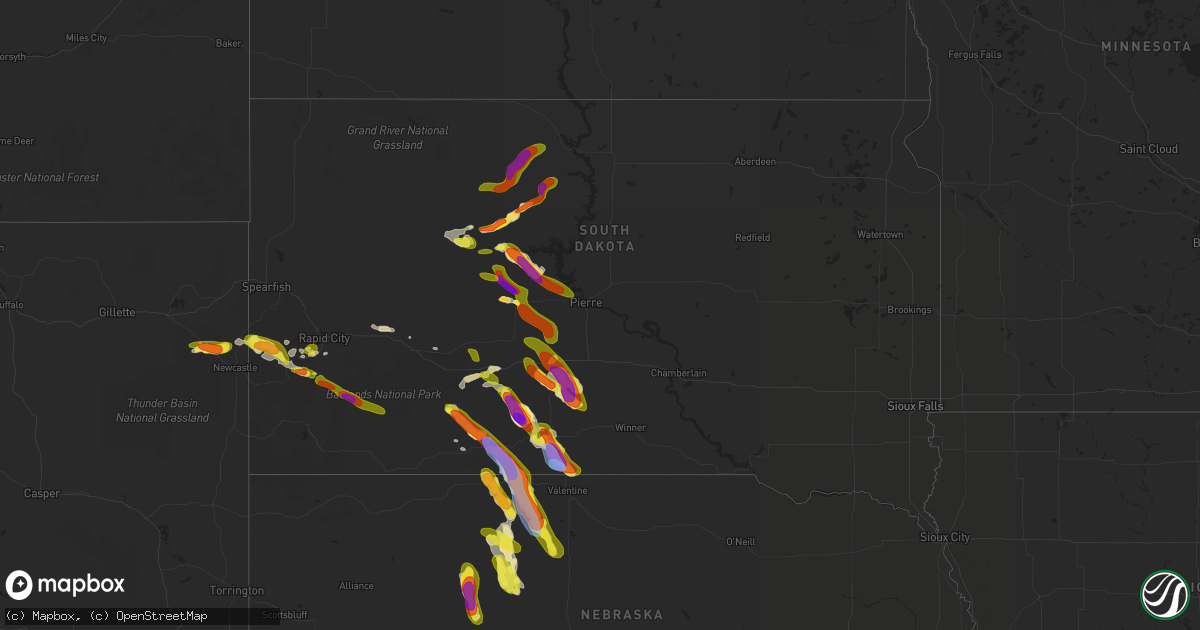
Hail Map in South Dakota on August 26, 2020
Get this storm
August 26 map
$229
one time, instant access
Download today. No call, no setup
Keep the $229
Bought the map and want the full workflow? Apply the entire $229 to a subscription within 7 days. None of it is wasted.
Every map, not just this one
This buys you this map. Subscription and you get every map we run, in the markets you choose from a few cities to whole states to nationwide. Plus real-time alerts the moment a storm fires.
Contact data
Name, contact info, occupancy, even credit band for addresses in the footprint. You go from where it hit to who to call.
Become the source they trust
Unlimited branding weather history reports on demand. You already have the documented answer ready for the property owner, and you are the one who showed up with it.
Property data and RoofTrace estimates
Pull up any address you have got, its value and the exact code rules for that jurisdiction, straight from One Click Code. Then RoofTrace estimates the squares, pitch, and roof value, priced the way you price.
Storm reports in South Dakota
South Dakota
| Date | Description |
|---|---|
| 08/26/20206:30 PM CDT | Mesonet station grrs2 bullhead 10 s. Estimated time. |
| 08/26/20206:20 PM CDT | A local report indicates 58 MPH wind near 1 NE MIDLAND |
| 08/26/20206:20 PM CDT | Report of golfball and larger. |
| 08/26/20206:17 PM CDT | Update to previous report. |
| 08/26/20206:13 PM CDT | Relayed through spotter. |
| 08/26/20206:13 PM CDT | Relayed through spotter. |
| 08/26/20206:00 PM CDT | A local report indicates 1.00 inch wind near 12 ESE FAIRBURN |
| 08/26/20205:58 PM CDT | Time estimated. |
| 08/26/20205:48 PM CDT | Time estimated. Broke 6 windows on north and west side of residence. |
| 08/26/20205:31 PM CDT | A local report indicates 1.00 inch wind near 5 NNW FAIRBURN |
| 08/26/20205:25 PM CDT | A local report indicates 1.00 inch wind near 3 NW KIRLEY |
| 08/26/20204:45 PM CDT | Time estimated. |
| 08/26/20204:45 PM CDT | A local report indicates 60 MPH wind near 15 ENE CHERRY CREEK |
| 08/26/20204:30 PM CDT | Time estimated. Multiple sizes but largest was golf ball. Covered ground. |
| 08/26/20204:20 PM CDT | Roof torn off one outbuilding... A second outbuilding had north door blown in. Time estimated. |
| 08/26/20204:20 PM CDT | Time estimated. |
| 08/26/20204:17 PM CDT | Mesonet station 168 foster bay |
| 08/26/20204:06 PM CDT | Update to previous report. |
| 08/26/20204:02 PM CDT | Slightly larger then quarters. |
| 08/26/20204:00 PM CDT | Most hail was nickel size |
| 08/26/20206:00 AM CDT | A local report indicates 1.25 inch wind near 4 SE DEERFIELD |
| 08/26/20204:15 AM CDT | At 915 PM CDT, a severe thunderstorm was located near Littleburg, or 13 miles north of Valentine, moving southeast at 30 mph. HAZARD...Golf ball size hail and 60 mph wind gusts. SOURCE...Radar indicated. IMPACT...People and animals outdoors will be injured. Expect hail damage to roofs, siding, windows, and vehicles. Expect wind damage to roofs, siding, and trees. Locations impacted include... Valentine, Sparks and Smith Falls State Park. This includes the following highways... Highway 20 between mile markers 195 and 207. Highway 97 between mile markers 140 and 141. Highway 83 between mile markers 203 and 222. Highway 12 between mile markers 1 and 27. |
| 08/26/20204:01 AM CDT | At 900 PM CDT, a severe thunderstorm was located 6 miles east of Lakeview, or 14 miles south of Mission, moving southeast at 30 mph. HAZARD...Golf ball size hail and 60 mph wind gusts. SOURCE...Radar indicated. IMPACT...People and animals outdoors will be injured. Expect hail damage to roofs, siding, windows, and vehicles. Expect wind damage to roofs, siding, and trees. This severe thunderstorm will be near... Littleburg around 920 PM CDT. |
| 08/26/20203:56 AM CDT | At 856 PM CDT/756 PM MDT/, a severe thunderstorm was located 8 miles northeast of Cody, or 30 miles east of Martin, moving southeast at 30 mph. HAZARD...Ping pong ball size hail and 60 mph wind gusts. SOURCE...Radar indicated. IMPACT...People and animals outdoors will be injured. Expect hail damage to roofs, siding, windows, and vehicles. Expect wind damage to roofs, siding, and trees. Locations impacted include... Cody, Kilgore, Nenzel, Crookston, Steer Creek Campground and Anderson Bridge State Wildlife Management Area.This includes Highway 20 between mile markers 155 and 189. |
| 08/26/20203:09 AM CDT | At 809 PM CDT, a severe thunderstorm was located 3 miles east of Wood, or 17 miles east of White River, moving southeast at 35 mph. HAZARD...Golf ball size hail and 60 mph wind gusts. SOURCE...Radar indicated. IMPACT...People and animals outdoors will be injured. Expect hail damage to roofs, siding, windows, and vehicles. Expect wind damage to roofs, siding, and trees. This severe thunderstorm will be near... Mosher around 820 PM CDT. Okreek around 825 PM CDT. Carter around 830 PM CDT. Witten around 835 PM CDT. Clearfield around 900 PM CDT. Dog Ear Lake around 910 PM CDT. |
| 08/26/20202:18 AM CDT | At 718 PM CDT, a severe thunderstorm was located near Westover, or near Murdo, moving southeast at 30 mph. HAZARD...60 mph wind gusts and quarter size hail. SOURCE...Radar indicated. IMPACT...Hail damage to vehicles is expected. Expect wind damage to roofs, siding, and trees. Locations impacted include... Murdo and Westover. |
| 08/26/20202:13 AM CDT | At 713 PM MDT/813 PM CDT/, a severe thunderstorm was located 5 miles northeast of Parmelee, or 14 miles west of Mission, moving southeast at 30 mph. HAZARD...Tennis ball size hail and 60 mph wind gusts. SOURCE...Radar indicated. IMPACT...People and animals outdoors will be injured. Expect hail damage to roofs, siding, windows, and vehicles. Expect wind damage to roofs, siding, and trees. This severe thunderstorm will be near... Rosebud around 835 PM CDT. Mission around 840 PM CDT. Lakeview around 850 PM CDT. |
| 08/26/20202:11 AM CDT | At 711 PM MDT/811 PM CDT/, a severe thunderstorm was located 5 miles northwest of Vetal, or 14 miles northeast of Martin, moving southeast at 35 mph. HAZARD...Two inch hail and 60 mph wind gusts. SOURCE...Radar indicated. IMPACT...People and animals outdoors will be injured. Expect hail damage to roofs, siding, windows, and vehicles. Expect wind damage to roofs, siding, and trees. This severe thunderstorm will be near... Tuthill and Vetal around 720 PM MDT. Harrington around 735 PM MDT. |
| 08/26/20201:32 AM CDT | At 631 PM CDT/531 PM MDT/, a severe thunderstorm was located over Van Metre, or 17 miles north of Murdo, moving southeast at 35 mph. HAZARD...60 mph wind gusts and quarter size hail. SOURCE...Radar indicated. IMPACT...Hail damage to vehicles is expected. Expect wind damage to roofs, siding, and trees. Locations impacted include... Murdo, Draper, Okaton, Capa, Wendte and Van Metre. |
| 08/26/20201:20 AM CDT | At 620 PM MDT/720 PM CDT/, severe thunderstorms were located along a line extending from 6 miles southeast of Okaton to 10 miles south of Belvidere to 6 miles northeast of Snake Butte, moving southeast at 30 mph. HAZARD...60 mph wind gusts and quarter size hail. SOURCE...Radar indicated. IMPACT...Hail damage to vehicles is expected. Expect wind damage to roofs, siding, and trees. Severe thunderstorms will be near... Cedar Butte around 745 PM CDT. Long Valley around 750 PM CDT. White River around 810 PM CDT. Vetal around 815 PM CDT. |
| 08/26/202012:35 AM CDT | At 535 PM MDT, a severe thunderstorm was located 8 miles east of Intersection of Red Shirt and Cuny Table Roads, or 32 miles north of Pine Ridge, moving southeast at 30 mph. HAZARD...Ping pong ball size hail and 60 mph wind gusts. SOURCE...Radar indicated. IMPACT...People and animals outdoors will be injured. Expect hail damage to roofs, siding, windows, and vehicles. Expect wind damage to roofs, siding, and trees. This severe thunderstorm will be near... Sharps Corner around 605 PM MDT. Manderson around 610 PM MDT. Porcupine around 620 PM MDT. |
| 08/26/202012:11 AM CDT | At 510 PM MDT, a severe thunderstorm was located over Timber Lake, or 27 miles southwest of Mclaughlin, moving northeast at 30 mph. HAZARD...Golf ball size hail and 60 mph wind gusts. SOURCE...Radar indicated. IMPACT...People and animals outdoors will be injured. Expect hail damage to roofs, siding, windows, and vehicles. Expect wind damage to roofs, siding, and trees. Locations impacted include... Timber Lake, Little Moreau Rec Area, Spring Lake, Glencross and Little Eagle. |
| 08/25/202011:45 PM CDT | At 444 PM CDT/344 PM MDT/, a severe thunderstorm was located 9 miles south of Mission Ridge, or 23 miles northwest of Fort Pierre, moving southeast at 30 mph. HAZARD...Ping pong ball size hail and 60 mph wind gusts. SOURCE...Radar indicated. IMPACT...People and animals outdoors will be injured. Expect hail damage to roofs, siding, windows, and vehicles. Expect wind damage to roofs, siding, and trees. Locations impacted include... Grey Goose, Okobojo Point Rec Area, Overlook Rec Area, Spring Creek Rec Area, Cow Creek Rec Area, West Shore Rec Area, Oahe Mission Rec Area and Chantier Creek Recreation Area. |
| 08/25/202011:34 PM CDT | At 434 PM MDT, a severe thunderstorm was located near Kirley, or 33 miles south of Eagle Butte, moving southeast at 30 mph. HAZARD...Ping pong ball size hail and 60 mph wind gusts. SOURCE...Radar indicated. IMPACT...People and animals outdoors will be injured. Expect hail damage to roofs, siding, windows, and vehicles. Expect wind damage to roofs, siding, and trees. Locations impacted include... Sansarc, Brown Church and Hayes. |
| 08/25/202011:29 PM CDT | At 428 PM MDT, a severe thunderstorm was located 3 miles northwest of Fairburn, or 18 miles east of Custer, moving southeast at 20 mph. HAZARD...60 mph wind gusts and quarter size hail. SOURCE...Radar indicated. IMPACT...Hail damage to vehicles is expected. Expect wind damage to roofs, siding, and trees. This severe thunderstorm will be near... Fairburn around 435 PM MDT. Red Shirt around 515 PM MDT. Red Shirt Table Overlook around 525 PM MDT. |
| 08/25/202011:22 PM CDT | At 421 PM MDT, a severe thunderstorm was located 4 miles north of Kirley, or 28 miles south of Eagle Butte, moving southeast at 20 mph. HAZARD...Ping pong ball size hail and 60 mph wind gusts. SOURCE...Radar indicated. IMPACT...People and animals outdoors will be injured. Expect hail damage to roofs, siding, windows, and vehicles. Expect wind damage to roofs, siding, and trees. This severe thunderstorm will be near... Kirley around 430 PM MDT. |
| 08/25/202011:18 PM CDT | At 417 PM MDT, a severe thunderstorm was located 7 miles south of Isabel, or 18 miles north of Lantry, moving east at 20 mph. HAZARD...60 mph wind gusts and half dollar size hail. SOURCE...Radar indicated. IMPACT...Hail damage to vehicles is expected. Expect wind damage to roofs, siding, and trees. Locations impacted include... Timber Lake and Little Moreau Rec Area. |
| 08/25/202011:13 PM CDT | At 413 PM MDT, a severe thunderstorm was located near White Horse, or 22 miles northeast of Eagle Butte, moving northeast at 20 mph. HAZARD...Ping pong ball size hail and 60 mph wind gusts. SOURCE...Radar indicated. IMPACT...People and animals outdoors will be injured. Expect hail damage to roofs, siding, windows, and vehicles. Expect wind damage to roofs, siding, and trees. Locations impacted include... Promise and White Horse. |
| 08/25/202010:27 PM CDT | At 326 PM MDT, a severe thunderstorm was located 5 miles southwest of Intersection of Cherry Creek and Sunnybrook Roads, or 16 miles south of Dupree, moving southeast at 25 mph. HAZARD...60 mph wind gusts and half dollar size hail. SOURCE...Radar indicated. IMPACT...Hail damage to vehicles is expected. Expect wind damage to roofs, siding, and trees. This severe thunderstorm will be near... Intersection of Cherry Creek and Sunnybrook Roads around 335 PM MDT. |
| 08/25/202010:27 PM CDT | At 326 PM MDT, a severe thunderstorm was located near Parade, or 7 miles northeast of Eagle Butte, moving northeast at 25 mph. HAZARD...60 mph wind gusts and half dollar size hail. SOURCE...Radar indicated. IMPACT...Hail damage to vehicles is expected. Expect wind damage to roofs, siding, and trees. Locations impacted include... Parade and Ridgeview. |
| 08/25/202010:01 PM CDT | At 300 PM MDT, a severe thunderstorm was located over southwestern Lake Oahe, or 20 miles southeast of Eagle Butte, moving east at 30 mph. HAZARD...Ping pong ball size hail and 60 mph wind gusts. SOURCE...Radar indicated. IMPACT...People and animals outdoors will be injured. Expect hail damage to roofs, siding, windows, and vehicles. Expect wind damage to roofs, siding, and trees. Locations impacted include... Mission Ridge. |
| 08/25/20209:48 PM CDT | At 247 PM MDT, a severe thunderstorm was located near Lantry, moving northeast at 20 mph. HAZARD...60 mph wind gusts and quarter size hail. SOURCE...Radar indicated. IMPACT...Hail damage to vehicles is expected. Expect wind damage to roofs, siding, and trees. Locations impacted include... Eagle Butte, Lantry, Parade and Green Grass. |
| 08/25/20209:28 PM CDT | At 228 PM MDT, a severe thunderstorm was located 6 miles south of Lantry, moving east at 15 mph. HAZARD...Ping pong ball size hail and 60 mph wind gusts. SOURCE...Radar indicated. IMPACT...People and animals outdoors will be injured. Expect hail damage to roofs, siding, windows, and vehicles. Expect wind damage to roofs, siding, and trees. Locations impacted include... South Eagle Butte and Intersection of Highway 63 and BIA Road 8. |
| 08/25/20209:04 PM CDT | A local report indicates 76 MPH wind near 15 SSE MISSION |
| 08/25/20208:59 PM CDT | A local report indicates 71 MPH wind near 15 SSE MISSION |
| 08/25/20208:45 PM CDT | A local report indicates 66 MPH wind near 7 ESE ROSEBUD |
| 08/25/20208:25 PM CDT | A local report indicates 60 MPH wind near 1 NW VETAL |
| 08/25/20208:25 PM CDT | A local report indicates 1.00 inch wind near 1 NW VETAL |
| 08/25/20208:10 PM CDT | A local report indicates 1.50 inch wind near 4 NE WOOD |
| 08/25/20208:00 PM CDT | A local report indicates 2.50 inch wind near 5 ESE NORRIS |
| 08/25/20208:00 PM CDT | Broken windshield to law enforcement vehicle |
| 08/25/20207:40 PM CDT | A local report indicates 1.00 inch wind near 7 W CEDAR BUTTE |
| 08/25/20207:37 PM CDT | A local report indicates 1.00 inch wind near 14 ESE POTATO CREEK |
| 08/25/20207:25 PM CDT | Time estimated. |
All States Impacted by Hail Map on August 26, 2020
Cities Impacted by Hail Map on August 26, 2020
- Macksburg, OH
- Cumberland, OH
- Caldwell, OH
- Dexter City, OH
- Belle Valley, OH
- Wood, SD
- Norris, SD
- Hill City, SD
- Draper, SD
- Blackfoot, ID
- Eagle Butte, SD
- Glouster, OH
- Chesterhill, OH
- Malta, OH
- Cody, NE
- Kilgore, NE
- Saint Francis, SD
- Nenzel, NE
- Merriman, NE
- Hyannis, NE
- Whitman, NE
- Osage, WY
- Valentine, NE
- Idaho Falls, ID
- Allen, SD
- Newcastle, WY
- Custer, SD
- Richfield, ID
- Kadoka, SD
- Martin, SD
- Round O, SC
- Sula, MT
- Conner, MT
- Dupree, SD
- Sells, AZ
- Owanka, SD
- Wanblee, SD
- Hayes, SD
- Stockport, OH
- Waterford, OH
- Belvidere, SD
- Adamsville, OH
- Thedford, NE
- Tuthill, SD
- Groveport, OH
- Canal Winchester, OH
- Pickerington, OH
- Baltic, OH
- Millersburg, OH
- Sugarcreek, OH
- Mission, SD
- White River, SD
- Garryowen, MT
- Saint Xavier, MT
- Lodge Grass, MT
- Riverside, OR
- Adrian, OR
- Murdo, SD
- Okaton, SD
- Long Valley, SD
- Midland, SD
- Lowell, OH
- Wasta, SD
- Harrison, MT
- Cardwell, MT
- Norris, MT
- Manistique, MI
- Fort Pierre, SD
- Upton, WY
- Cottageville, SC
- Lawrenceville, GA
- Mullen, NE
- Darby, MT
- Brinkley, AR
- Des Arc, AR
- Fresno, OH
- Holmesville, OH
- Rosebud, SD
- Parmelee, SD
- Carroll, OH
- Mcconnelsville, OH
- Washington, GA
- Burns, OR
- Rapid City, SD
- Charleston, SC
- Cooks, MI
- Hermosa, SD
- New Concord, OH
- Norwich, OH
- Cambridge, OH
- Keystone, SD
- Crystal Falls, MI
- Busby, MT
- Yale, OK
- Philip, SD
- Ironside, OR
- Unity, OR
- Crenshaw, MS
- Rigby, ID
- Pawnee, OK
- Kingston, OH
- Laurelville, OH
- Sherwood, AR
- Jacksonville, AR
- North Little Rock, AR
- Ashton, ID
- Lonsdale, AR
- Benton, AR
- Wall, SD
- Hereford, OR
- Kimbolton, OH
- Conesville, OH
- Coshocton, OH
- Senatobia, MS
- King Hill, ID
- Bruneau, ID
- Hagerman, ID
- Munising, MI
- Shawnee, OK
- Wetmore, MI
- McLaughlin, SD
- Deerton, MI
- Kewadin, MI
- Walterboro, SC
- Beverly, OH
- Como, MS
- Gibbonsville, ID
- Birney, MT
- New Straitsville, OH
- Hines, OR
- Princeton, OR
- Zanesville, OH
- Nashport, OH
- Lula, GA
- Gillsville, GA
- Grand Rapids, MN
- Theriot, LA
- Chauvin, LA
- Dulac, LA
- Vinton, LA
- Iowa, LA
- Cameron, LA
- Grand Chenier, LA
- Bell City, LA
- Lake Charles, LA
- Orange, TX
- Westlake, LA
- Creole, LA
- Sulphur, LA
- Hackberry, LA
- Addis, LA
- Lakeland, LA
- Port Allen, LA
- Brusly, LA
- Fordoche, LA
- Morganza, LA
- Erwinville, LA
- Oscar, LA
- Baton Rouge, LA
- Livonia, LA
- Donaldsonville, LA
- Belle Rose, LA
- White Castle, LA
- Darrow, LA
- Saint James, LA
- Rougon, LA
- Jarreau, LA
- Ventress, LA
- New Roads, LA
- Glynn, LA
- Gonzales, LA
- Prairieville, LA
- Saint Amant, LA
- Spurger, TX
- Woodville, TX
- Silsbee, TX
- Warren, TX
- Hillister, TX
- Fred, TX
- Basile, LA
- Crowley, LA
- Rayne, LA
- Iota, LA
- Grosse Tete, LA
- Lottie, LA
- Maringouin, LA
- Sunshine, LA
- Plaquemine, LA
- Saint Gabriel, LA
- Carville, LA
- Geismar, LA
- Ville Platte, LA
- Saint Landry, LA
- Bunkie, LA
- Merryville, LA
- Burkeville, TX
- Newton, TX
- Lockport, LA
- Des Allemands, LA
- Cut Off, LA
- Pitkin, LA
- La Place, LA
- Ponchatoula, LA
- Walker, LA
- Livingston, LA
- Greenwell Springs, LA
- Denham Springs, LA
- Pride, LA
- Springfield, LA
- Holden, LA
- Jackson, LA
- Saint Francisville, LA
- Amite, LA
- Pine Grove, LA
- Albany, LA
- Tickfaw, LA
- Hammond, LA
- Greensburg, LA
- Clinton, LA
- Centreville, MS
- Norwood, LA
- Wilson, LA
- Independence, LA
- Zachary, LA
- Pierre Part, LA
- Monroe, LA
- Napoleonville, LA
- Port Barre, LA
- Sieper, LA
- Plattenville, LA
- Trout, LA
- Mittie, LA
- Lisbon, LA
- Grant, LA
- Magnolia, AR
- Downsville, LA
- Emerson, AR
- Jasper, TX
- Branch, LA
- Gilbert, LA
- Broaddus, TX
- Egan, LA
- Starks, LA
- Sterlington, LA
- Pleasant Hill, LA
- Cottonport, LA
- Choudrant, LA
- Minden, LA
- Shongaloo, LA
- Clayton, LA
- Buna, TX
- Morse, LA
- Bossier City, LA
- Elmer, LA
- Waldo, AR
- Barksdale Afb, LA
- Evergreen, LA
- Coushatta, LA
- El Dorado, AR
- Roanoke, LA
- Dodson, LA
- Pelican, LA
- Colfax, LA
- Hessmer, LA
- Benton, LA
- Vidalia, LA
- Cheneyville, LA
- Mora, LA
- Gilliam, LA
- Wisner, LA
- Hornbeck, LA
- Fouke, AR
- Rodessa, LA
- Longville, LA
- Brookeland, TX
- Lafayette, LA
- Marion, LA
- Ashland, LA
- Delcambre, LA
- Bethany, LA
- Rosedale, LA
- Winnfield, LA
- Bronson, TX
- Baldwin, LA
- Princeton, LA
- Mangham, LA
- Ball, LA
- Natchez, MS
- Fisher, LA
- Plain Dealing, LA
- Eunice, LA
- Olla, LA
- Batchelor, LA
- Farmerville, LA
- Lewisville, AR
- Gibsland, LA
- Vidor, TX
- Jena, LA
- Natchitoches, LA
- Keatchie, LA
- Sunset, LA
- Slagle, LA
- Collinston, LA
- Atlanta, LA
- Gueydan, LA
- Mamou, LA
- Mansura, LA
- Gloster, MS
- Provencal, LA
- Jamestown, LA
- Center Point, LA
- Columbia, LA
- Pineland, TX
- Glenmora, LA
- Many, LA
- Lorman, MS
- New Iberia, LA
- Evangeline, LA
- Sikes, LA
- Breaux Bridge, LA
- Georgetown, LA
- Anacoco, LA
- Angola, LA
- Waterproof, LA
- Robeline, LA
- Slaughter, LA
- Arnaudville, LA
- Oberlin, LA
- Elton, LA
- Pineville, LA
- Shreveport, LA
- Lena, LA
- Morrow, LA
- Sibley, LA
- Duson, LA
- Winnsboro, LA
- Oakdale, LA
- Call, TX
- Pollock, LA
- Elm Grove, LA
- Haughton, LA
- Lecompte, LA
- Grayson, LA
- Rayville, LA
- Flatwoods, LA
- Homer, LA
- Bon Wier, TX
- Ethel, LA
- Summerfield, LA
- Junction City, AR
- Youngsville, LA
- Melville, LA
- Gloster, LA
- Bentley, LA
- Dequincy, LA
- Forest Hill, LA
- Lacassine, LA
- Leesville, LA
- Simmesport, LA
- Keithville, LA
- Joaquin, TX
- Tallulah, LA
- Deweyville, TX
- Otis, LA
- Jonesboro, LA
- Saline, LA
- Hineston, LA
- Morgan City, LA
- Deville, LA
- Sicily Island, LA
- Stephens, AR
- Shelbyville, TX
- Bastrop, LA
- Fort Necessity, LA
- Roxie, MS
- Dubach, LA
- Boyce, LA
- Lake Arthur, LA
- Harrisonburg, LA
- Oil City, LA
- Quitman, LA
- Hall Summit, LA
- Erath, LA
- Reeves, LA
- Montgomery, LA
- Loreauville, LA
- Lillie, LA
- Kirbyville, TX
- Baker, LA
- Krotz Springs, LA
- Dry Prong, LA
- Bridge City, TX
- De Berry, TX
- Doyline, LA
- Aimwell, LA
- Elizabeth, LA
- San Augustine, TX
- Natchez, LA
- Lettsworth, LA
- Dry Creek, LA
- Milam, TX
- Castor, LA
- Mansfield, LA
- Alexandria, LA
- Franklin, LA
- Jonesville, LA
- Grambling, LA
- Ruston, LA
- West Monroe, LA
- Doddridge, AR
- Center, TX
- Greenwood, LA
- Monterey, LA
- Plaucheville, LA
- Saint Joseph, LA
- Kinder, LA
- Delhi, LA
- Ringgold, LA
- Welsh, LA
- Sugartown, LA
- Crosby, MS
- Acme, LA
- Enterprise, LA
- Campti, LA
- Groves, TX
- Cloutierville, LA
- Simsboro, LA
- Marthaville, LA
- Sarepta, LA
- Deridder, LA
- Dubberly, LA
- Scott, LA
- Port Arthur, TX
- Patterson, LA
- Opelousas, LA
- Bradley, AR
- New Llano, LA
- Rosepine, LA
- Broussard, LA
- Frierson, LA
- Ragley, LA
- Belmont, LA
- Effie, LA
- Belcher, LA
- Mooringsport, LA
- Moreauville, LA
- Kelly, LA
- Berwick, LA
- McNeil, AR
- Carthage, TX
- Carencro, LA
- Jennings, LA
- Wiergate, TX
- Woodworth, LA
- Calhoun, LA
- Jeanerette, LA
- Baskin, LA
- Fayette, MS
- Oak Ridge, LA
- Chatham, LA
- Mount Holly, AR
- Hemphill, TX
- Church Point, LA
- Simpson, LA
- Bienville, LA
- Goldonna, LA
- Converse, LA
- Saint Martinville, LA
- Blanchard, LA
- Arcadia, LA
- Bernice, LA
- Stamps, AR
- Vivian, LA
- Haynesville, LA
- Buckner, AR
- Tullos, LA
- Stonewall, LA
- Spearsville, LA
- Taylor, AR
- Fort Polk, LA
- Noble, LA
- Evans, LA
- Ida, LA
- Washington, LA
- Hosston, LA
- Waskom, TX
- Melrose, LA
- Estherwood, LA
- Athens, LA
- Cotton Valley, LA
- Garland City, AR
- Palmetto, LA
- Grand Cane, LA
- Woodville, MS
- Heflin, LA
- Logansport, LA
- Singer, LA
- Kaplan, LA
- Newellton, LA
- Florien, LA
- Maurice, LA
- Eros, LA
- Ferriday, LA
- Sabine Pass, TX
- Abbeville, LA
- Gibson, LA
- Marksville, LA
- Zwolle, LA
- Mermentau, LA
- Springhill, LA
- Kentwood, LA
- Roseland, LA
- Loranger, LA
- Bono, AR
- Weiner, AR
- Jonesboro, AR
- Trumann, AR
- Bay, AR
- Paragould, AR
- Harrisburg, AR
- Walnut Ridge, AR
- State University, AR
- Marked Tree, AR
- Beech Grove, AR
- Maynard, AR
- Biggers, AR
- Pocahontas, AR
- Monette, AR
- Knobel, AR
- Lafe, AR
- Lepanto, AR
- Black Oak, AR
- Marmaduke, AR
- Gatewood, MO
- Leachville, AR
- Brookland, AR
- Tyronza, AR
- Peach Orchard, AR
- Caraway, AR
- Warm Springs, AR
- Datto, AR
- Doniphan, MO
- Corning, AR
- Delaplaine, AR
- Cardwell, MO
- Lake City, AR
- Couch, MO
- Malden, MO
- Gideon, MO
- Kennett, MO
- Holcomb, MO
- Gobler, MO
- Clarkton, MO
- Ripley, TN
- Bragg City, MO
- Steele, MO
- Blytheville, AR
- Campbell, MO
- Cotton Plant, AR
- Hunter, AR
- Thida, AR
- Newport, AR
- Augusta, AR
- Beedeville, AR
- McCrory, AR
- Oil Trough, AR
- Pleasant Plains, AR
- Wynne, AR
- Bradford, AR
- Hickory Ridge, AR
- Tuckerman, AR
- Charlotte, AR
- Amagon, AR
- Batesville, AR
- Newark, AR
- Sulphur Rock, AR
- Smithville, AR
- Strawberry, AR
- Powhatan, AR
- Cash, AR
- Black Rock, AR
- Swifton, AR
- Evening Shade, AR
- Alicia, AR
- Lynn, AR
- Poughkeepsie, AR
- Fisher, AR
- Grand View, ID
- Arco, ID
- Shelley, ID
- Moore, ID
- Atomic City, ID
- Carey, ID
- Grand Marais, MN
- Timber Lake, SD
- Trail City, SD
- Isabel, SD
- Pine Ridge, SD
- Fairburn, SD


