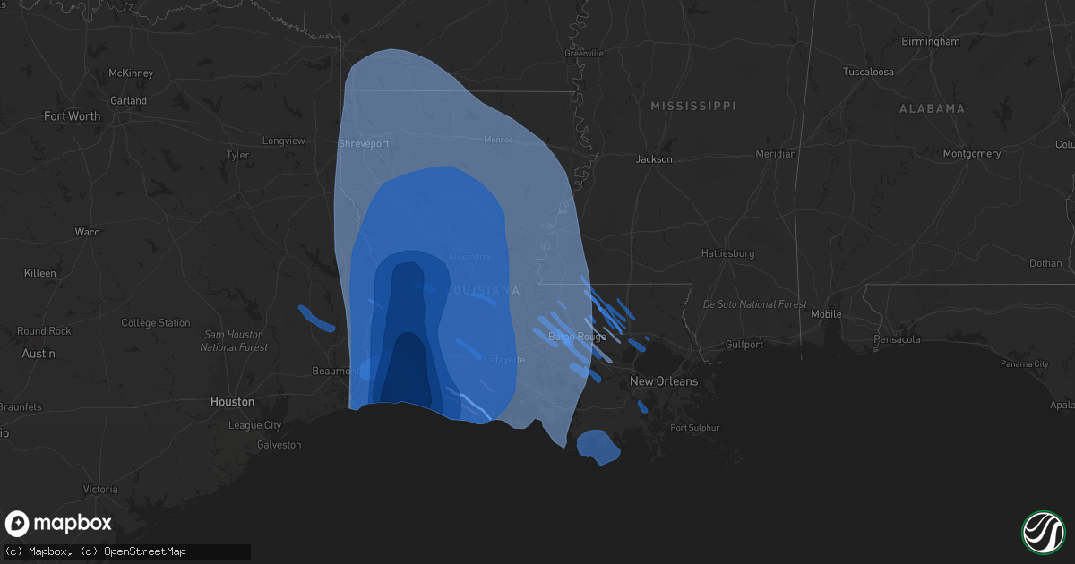
Hail Map in Louisiana on August 26, 2020
Get this storm
August 26 map
$229
one time, instant access
Download today. No call, no setup
Keep the $229
Bought the map and want the full workflow? Apply the entire $229 to a subscription within 7 days. None of it is wasted.
Every map, not just this one
This buys you this map. Subscription and you get every map we run, in the markets you choose from a few cities to whole states to nationwide. Plus real-time alerts the moment a storm fires.
Contact data
Name, contact info, occupancy, even credit band for addresses in the footprint. You go from where it hit to who to call.
Become the source they trust
Unlimited branding weather history reports on demand. You already have the documented answer ready for the property owner, and you are the one who showed up with it.
Property data and RoofTrace estimates
Pull up any address you have got, its value and the exact code rules for that jurisdiction, straight from One Click Code. Then RoofTrace estimates the squares, pitch, and roof value, priced the way you price.
Storm reports in Louisiana
Louisiana
| Date | Description |
|---|---|
| 08/26/20201:55 PM CDT | Public called in report of a tornado touchdown near paincourtville. No damage reported. |
| 08/26/20207:14 AM CDT | At 1213 PM CDT, severe thunderstorms were located along a line extending from 20 miles south of Bayou Vista to 12 miles south of Amelia to 13 miles southwest of Bayou Cane to 7 miles southwest of Houma to 11 miles west of Leeville, moving north at 45 mph. HAZARD...60 mph wind gusts. SOURCE...Radar indicated. IMPACT...Expect damage to roofs, siding, and trees. Locations impacted include... Houma, Thibodaux, Lockport, Schriever, Supreme, Gray, Chauvin, Dulac, Labadieville, Montegut, Bayou Cane and Raceland. |
| 08/25/202010:48 PM CDT | At 348 PM CDT, a severe thunderstorm was located near French Settlement, or 14 miles northeast of Gonzales, moving northwest at 35 mph. HAZARD...60 mph wind gusts. SOURCE...Radar indicated. IMPACT...Expect damage to roofs, siding, and trees. Locations impacted include... Denham Springs, Walker, Livingston, French Settlement, Port Vincent and Watson. |
| 08/25/202010:00 PM CDT | Spotter report of a rain wrapped tornado near bell city. |
All States Impacted by Hail Map on August 26, 2020
Cities Impacted by Hail Map on August 26, 2020
- Macksburg, OH
- Cumberland, OH
- Caldwell, OH
- Dexter City, OH
- Belle Valley, OH
- Wood, SD
- Norris, SD
- Hill City, SD
- Draper, SD
- Blackfoot, ID
- Eagle Butte, SD
- Glouster, OH
- Chesterhill, OH
- Malta, OH
- Cody, NE
- Kilgore, NE
- Saint Francis, SD
- Nenzel, NE
- Merriman, NE
- Hyannis, NE
- Whitman, NE
- Osage, WY
- Valentine, NE
- Idaho Falls, ID
- Allen, SD
- Newcastle, WY
- Custer, SD
- Richfield, ID
- Kadoka, SD
- Martin, SD
- Round O, SC
- Sula, MT
- Conner, MT
- Dupree, SD
- Sells, AZ
- Owanka, SD
- Wanblee, SD
- Hayes, SD
- Stockport, OH
- Waterford, OH
- Belvidere, SD
- Adamsville, OH
- Thedford, NE
- Tuthill, SD
- Groveport, OH
- Canal Winchester, OH
- Pickerington, OH
- Baltic, OH
- Millersburg, OH
- Sugarcreek, OH
- Mission, SD
- White River, SD
- Garryowen, MT
- Saint Xavier, MT
- Lodge Grass, MT
- Riverside, OR
- Adrian, OR
- Murdo, SD
- Okaton, SD
- Long Valley, SD
- Midland, SD
- Lowell, OH
- Wasta, SD
- Harrison, MT
- Cardwell, MT
- Norris, MT
- Manistique, MI
- Fort Pierre, SD
- Upton, WY
- Cottageville, SC
- Lawrenceville, GA
- Mullen, NE
- Darby, MT
- Brinkley, AR
- Des Arc, AR
- Fresno, OH
- Holmesville, OH
- Rosebud, SD
- Parmelee, SD
- Carroll, OH
- Mcconnelsville, OH
- Washington, GA
- Burns, OR
- Rapid City, SD
- Charleston, SC
- Cooks, MI
- Hermosa, SD
- New Concord, OH
- Norwich, OH
- Cambridge, OH
- Keystone, SD
- Crystal Falls, MI
- Busby, MT
- Yale, OK
- Philip, SD
- Ironside, OR
- Unity, OR
- Crenshaw, MS
- Rigby, ID
- Pawnee, OK
- Kingston, OH
- Laurelville, OH
- Sherwood, AR
- Jacksonville, AR
- North Little Rock, AR
- Ashton, ID
- Lonsdale, AR
- Benton, AR
- Wall, SD
- Hereford, OR
- Kimbolton, OH
- Conesville, OH
- Coshocton, OH
- Senatobia, MS
- King Hill, ID
- Bruneau, ID
- Hagerman, ID
- Munising, MI
- Shawnee, OK
- Wetmore, MI
- McLaughlin, SD
- Deerton, MI
- Kewadin, MI
- Walterboro, SC
- Beverly, OH
- Como, MS
- Gibbonsville, ID
- Birney, MT
- New Straitsville, OH
- Hines, OR
- Princeton, OR
- Zanesville, OH
- Nashport, OH
- Lula, GA
- Gillsville, GA
- Grand Rapids, MN
- Theriot, LA
- Chauvin, LA
- Dulac, LA
- Vinton, LA
- Iowa, LA
- Cameron, LA
- Grand Chenier, LA
- Bell City, LA
- Lake Charles, LA
- Orange, TX
- Westlake, LA
- Creole, LA
- Sulphur, LA
- Hackberry, LA
- Addis, LA
- Lakeland, LA
- Port Allen, LA
- Brusly, LA
- Fordoche, LA
- Morganza, LA
- Erwinville, LA
- Oscar, LA
- Baton Rouge, LA
- Livonia, LA
- Donaldsonville, LA
- Belle Rose, LA
- White Castle, LA
- Darrow, LA
- Saint James, LA
- Rougon, LA
- Jarreau, LA
- Ventress, LA
- New Roads, LA
- Glynn, LA
- Gonzales, LA
- Prairieville, LA
- Saint Amant, LA
- Spurger, TX
- Woodville, TX
- Silsbee, TX
- Warren, TX
- Hillister, TX
- Fred, TX
- Basile, LA
- Crowley, LA
- Rayne, LA
- Iota, LA
- Grosse Tete, LA
- Lottie, LA
- Maringouin, LA
- Sunshine, LA
- Plaquemine, LA
- Saint Gabriel, LA
- Carville, LA
- Geismar, LA
- Ville Platte, LA
- Saint Landry, LA
- Bunkie, LA
- Merryville, LA
- Burkeville, TX
- Newton, TX
- Lockport, LA
- Des Allemands, LA
- Cut Off, LA
- Pitkin, LA
- La Place, LA
- Ponchatoula, LA
- Walker, LA
- Livingston, LA
- Greenwell Springs, LA
- Denham Springs, LA
- Pride, LA
- Springfield, LA
- Holden, LA
- Jackson, LA
- Saint Francisville, LA
- Amite, LA
- Pine Grove, LA
- Albany, LA
- Tickfaw, LA
- Hammond, LA
- Greensburg, LA
- Clinton, LA
- Centreville, MS
- Norwood, LA
- Wilson, LA
- Independence, LA
- Zachary, LA
- Pierre Part, LA
- Monroe, LA
- Napoleonville, LA
- Port Barre, LA
- Sieper, LA
- Plattenville, LA
- Trout, LA
- Mittie, LA
- Lisbon, LA
- Grant, LA
- Magnolia, AR
- Downsville, LA
- Emerson, AR
- Jasper, TX
- Branch, LA
- Gilbert, LA
- Broaddus, TX
- Egan, LA
- Starks, LA
- Sterlington, LA
- Pleasant Hill, LA
- Cottonport, LA
- Choudrant, LA
- Minden, LA
- Shongaloo, LA
- Clayton, LA
- Buna, TX
- Morse, LA
- Bossier City, LA
- Elmer, LA
- Waldo, AR
- Barksdale Afb, LA
- Evergreen, LA
- Coushatta, LA
- El Dorado, AR
- Roanoke, LA
- Dodson, LA
- Pelican, LA
- Colfax, LA
- Hessmer, LA
- Benton, LA
- Vidalia, LA
- Cheneyville, LA
- Mora, LA
- Gilliam, LA
- Wisner, LA
- Hornbeck, LA
- Fouke, AR
- Rodessa, LA
- Longville, LA
- Brookeland, TX
- Lafayette, LA
- Marion, LA
- Ashland, LA
- Delcambre, LA
- Bethany, LA
- Rosedale, LA
- Winnfield, LA
- Bronson, TX
- Baldwin, LA
- Princeton, LA
- Mangham, LA
- Ball, LA
- Natchez, MS
- Fisher, LA
- Plain Dealing, LA
- Eunice, LA
- Olla, LA
- Batchelor, LA
- Farmerville, LA
- Lewisville, AR
- Gibsland, LA
- Vidor, TX
- Jena, LA
- Natchitoches, LA
- Keatchie, LA
- Sunset, LA
- Slagle, LA
- Collinston, LA
- Atlanta, LA
- Gueydan, LA
- Mamou, LA
- Mansura, LA
- Gloster, MS
- Provencal, LA
- Jamestown, LA
- Center Point, LA
- Columbia, LA
- Pineland, TX
- Glenmora, LA
- Many, LA
- Lorman, MS
- New Iberia, LA
- Evangeline, LA
- Sikes, LA
- Breaux Bridge, LA
- Georgetown, LA
- Anacoco, LA
- Angola, LA
- Waterproof, LA
- Robeline, LA
- Slaughter, LA
- Arnaudville, LA
- Oberlin, LA
- Elton, LA
- Pineville, LA
- Shreveport, LA
- Lena, LA
- Morrow, LA
- Sibley, LA
- Duson, LA
- Winnsboro, LA
- Oakdale, LA
- Call, TX
- Pollock, LA
- Elm Grove, LA
- Haughton, LA
- Lecompte, LA
- Grayson, LA
- Rayville, LA
- Flatwoods, LA
- Homer, LA
- Bon Wier, TX
- Ethel, LA
- Summerfield, LA
- Junction City, AR
- Youngsville, LA
- Melville, LA
- Gloster, LA
- Bentley, LA
- Dequincy, LA
- Forest Hill, LA
- Lacassine, LA
- Leesville, LA
- Simmesport, LA
- Keithville, LA
- Joaquin, TX
- Tallulah, LA
- Deweyville, TX
- Otis, LA
- Jonesboro, LA
- Saline, LA
- Hineston, LA
- Morgan City, LA
- Deville, LA
- Sicily Island, LA
- Stephens, AR
- Shelbyville, TX
- Bastrop, LA
- Fort Necessity, LA
- Roxie, MS
- Dubach, LA
- Boyce, LA
- Lake Arthur, LA
- Harrisonburg, LA
- Oil City, LA
- Quitman, LA
- Hall Summit, LA
- Erath, LA
- Reeves, LA
- Montgomery, LA
- Loreauville, LA
- Lillie, LA
- Kirbyville, TX
- Baker, LA
- Krotz Springs, LA
- Dry Prong, LA
- Bridge City, TX
- De Berry, TX
- Doyline, LA
- Aimwell, LA
- Elizabeth, LA
- San Augustine, TX
- Natchez, LA
- Lettsworth, LA
- Dry Creek, LA
- Milam, TX
- Castor, LA
- Mansfield, LA
- Alexandria, LA
- Franklin, LA
- Jonesville, LA
- Grambling, LA
- Ruston, LA
- West Monroe, LA
- Doddridge, AR
- Center, TX
- Greenwood, LA
- Monterey, LA
- Plaucheville, LA
- Saint Joseph, LA
- Kinder, LA
- Delhi, LA
- Ringgold, LA
- Welsh, LA
- Sugartown, LA
- Crosby, MS
- Acme, LA
- Enterprise, LA
- Campti, LA
- Groves, TX
- Cloutierville, LA
- Simsboro, LA
- Marthaville, LA
- Sarepta, LA
- Deridder, LA
- Dubberly, LA
- Scott, LA
- Port Arthur, TX
- Patterson, LA
- Opelousas, LA
- Bradley, AR
- New Llano, LA
- Rosepine, LA
- Broussard, LA
- Frierson, LA
- Ragley, LA
- Belmont, LA
- Effie, LA
- Belcher, LA
- Mooringsport, LA
- Moreauville, LA
- Kelly, LA
- Berwick, LA
- McNeil, AR
- Carthage, TX
- Carencro, LA
- Jennings, LA
- Wiergate, TX
- Woodworth, LA
- Calhoun, LA
- Jeanerette, LA
- Baskin, LA
- Fayette, MS
- Oak Ridge, LA
- Chatham, LA
- Mount Holly, AR
- Hemphill, TX
- Church Point, LA
- Simpson, LA
- Bienville, LA
- Goldonna, LA
- Converse, LA
- Saint Martinville, LA
- Blanchard, LA
- Arcadia, LA
- Bernice, LA
- Stamps, AR
- Vivian, LA
- Haynesville, LA
- Buckner, AR
- Tullos, LA
- Stonewall, LA
- Spearsville, LA
- Taylor, AR
- Fort Polk, LA
- Noble, LA
- Evans, LA
- Ida, LA
- Washington, LA
- Hosston, LA
- Waskom, TX
- Melrose, LA
- Estherwood, LA
- Athens, LA
- Cotton Valley, LA
- Garland City, AR
- Palmetto, LA
- Grand Cane, LA
- Woodville, MS
- Heflin, LA
- Logansport, LA
- Singer, LA
- Kaplan, LA
- Newellton, LA
- Florien, LA
- Maurice, LA
- Eros, LA
- Ferriday, LA
- Sabine Pass, TX
- Abbeville, LA
- Gibson, LA
- Marksville, LA
- Zwolle, LA
- Mermentau, LA
- Springhill, LA
- Kentwood, LA
- Roseland, LA
- Loranger, LA
- Bono, AR
- Weiner, AR
- Jonesboro, AR
- Trumann, AR
- Bay, AR
- Paragould, AR
- Harrisburg, AR
- Walnut Ridge, AR
- State University, AR
- Marked Tree, AR
- Beech Grove, AR
- Maynard, AR
- Biggers, AR
- Pocahontas, AR
- Monette, AR
- Knobel, AR
- Lafe, AR
- Lepanto, AR
- Black Oak, AR
- Marmaduke, AR
- Gatewood, MO
- Leachville, AR
- Brookland, AR
- Tyronza, AR
- Peach Orchard, AR
- Caraway, AR
- Warm Springs, AR
- Datto, AR
- Doniphan, MO
- Corning, AR
- Delaplaine, AR
- Cardwell, MO
- Lake City, AR
- Couch, MO
- Malden, MO
- Gideon, MO
- Kennett, MO
- Holcomb, MO
- Gobler, MO
- Clarkton, MO
- Ripley, TN
- Bragg City, MO
- Steele, MO
- Blytheville, AR
- Campbell, MO
- Cotton Plant, AR
- Hunter, AR
- Thida, AR
- Newport, AR
- Augusta, AR
- Beedeville, AR
- McCrory, AR
- Oil Trough, AR
- Pleasant Plains, AR
- Wynne, AR
- Bradford, AR
- Hickory Ridge, AR
- Tuckerman, AR
- Charlotte, AR
- Amagon, AR
- Batesville, AR
- Newark, AR
- Sulphur Rock, AR
- Smithville, AR
- Strawberry, AR
- Powhatan, AR
- Cash, AR
- Black Rock, AR
- Swifton, AR
- Evening Shade, AR
- Alicia, AR
- Lynn, AR
- Poughkeepsie, AR
- Fisher, AR
- Grand View, ID
- Arco, ID
- Shelley, ID
- Moore, ID
- Atomic City, ID
- Carey, ID
- Grand Marais, MN
- Timber Lake, SD
- Trail City, SD
- Isabel, SD
- Pine Ridge, SD
- Fairburn, SD


