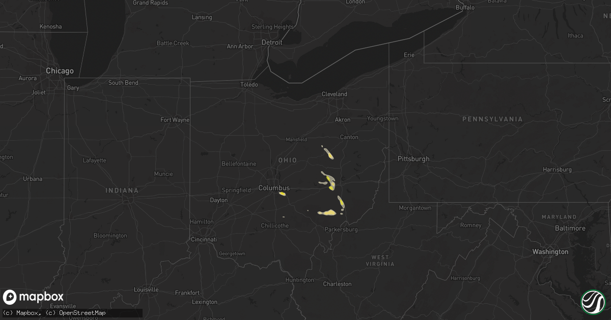
Hail Map in Ohio on August 26, 2020
Get this storm
August 26 map
$229
one time, instant access
Download today. No call, no setup
Keep the $229
Bought the map and want the full workflow? Apply the entire $229 to a subscription within 7 days. None of it is wasted.
Every map, not just this one
This buys you this map. Subscription and you get every map we run, in the markets you choose from a few cities to whole states to nationwide. Plus real-time alerts the moment a storm fires.
Contact data
Name, contact info, occupancy, even credit band for addresses in the footprint. You go from where it hit to who to call.
Become the source they trust
Unlimited branding weather history reports on demand. You already have the documented answer ready for the property owner, and you are the one who showed up with it.
Property data and RoofTrace estimates
Pull up any address you have got, its value and the exact code rules for that jurisdiction, straight from One Click Code. Then RoofTrace estimates the squares, pitch, and roof value, priced the way you price.
Storm reports in Ohio
Ohio
| Date | Description |
|---|---|
| 08/26/20202:58 PM CDT | Several trees down in town. Also pea to half inch size hail in the beverly-waterford area. |
| 08/26/20202:40 PM CDT | Numerous trees reported down in vicinity of piedmont lake dam. |
| 08/26/20202:35 PM CDT | Two trees down... One on state route 266... The other on roy gins road.. Time estimated from radar. |
| 08/26/20202:15 PM CDT | A local report indicates 1.00 inch wind near 7 WSW CAMBRIDGE |
| 08/26/20201:17 PM CDT | Small tree down in charm. |
| 08/26/202012:50 PM CDT | Power pole and wires down. |
| 08/25/202011:22 PM CDT | At 421 PM EDT, a severe thunderstorm was located near Caldwell, moving southeast at 15 mph. HAZARD...60 mph wind gusts and quarter size hail. SOURCE...Radar indicated. IMPACT...Hail damage to vehicles is expected. Expect wind damage to roofs, siding, and trees. Locations impacted include... Marietta, Lowell, Macksburg, Lower Salem and Devola. This includes Interstate 77 in Ohio between mile markers 4 and 17. |
| 08/25/202011:06 PM CDT | At 406 PM EDT, a severe thunderstorm was located over Caldwell, moving southeast at 20 mph. HAZARD...Wind gusts to 60 mph and quarter-size hail. SOURCE...Radar. IMPACT...Minor hail damage to vehicles is possible. Expect wind damage to trees and power lines, resulting in some power outages. Locations impacted include... Caldwell... Dudley... Dexter City... Stafford... Graysville... Harriettsville... Rinard Mills... This includes Interstate 77 in Ohio between mile markers 18 and 26. |
| 08/25/202010:29 PM CDT | At 329 PM EDT, a severe thunderstorm was located near New Concord, or 10 miles southwest of Cambridge, moving southeast at 20 mph. HAZARD...Wind gusts to 60 mph. SOURCE...Radar. IMPACT...Expect damage to trees and power lines, resulting in some power outages. Locations impacted include... Caldwell... Dudley... Pleasant City... Cumberland... Belle Valley... Sarahsville... Wolf Run State Park... This includes the following highways... Interstate 70 in Ohio near mile marker 173. Interstate 77 in Ohio between mile markers 22 and 40. |
| 08/25/20209:45 PM CDT | At 245 PM EDT, a severe thunderstorm was located 9 miles northwest of New Concord, or 10 miles south of Coshocton, moving southeast at 20 mph. HAZARD...Wind gusts to 60 mph and quarter-size hail. SOURCE...Radar. IMPACT...Minor hail damage to vehicles is possible. Expect wind damage to trees and power lines, resulting in some power outages. Locations impacted include... Cambridge... New Concord... Byesville... Norwich... Otsego... Boden...This includes the following highways... Interstate 70 in Ohio between mile markers 163 and 181. Interstate 77 in Ohio between mile markers 40 and 46. |
| 08/25/20209:17 PM CDT | At 217 PM EDT, a severe thunderstorm was located over Farmerstown, or 10 miles southeast of Millersburg, moving southeast at 15 mph. HAZARD...Wind gusts to 60 mph and half dollar-size hail. SOURCE...Radar. IMPACT...Minor hail damage to vehicles is possible. Expect wind damage to trees and power lines, resulting in some power outages. Locations impacted include... Newcomerstown... Sugarcreek... Baltic... Port Washington... Stone Creek... Chili... Bakersville... This includes Interstate 77 in Ohio between mile markers 66 and 77. |
| 08/25/20209:09 PM CDT | At 209 PM EDT, a severe thunderstorm was located over Walnut Creek, or 7 miles east of Millersburg, moving southeast at 25 mph. HAZARD...60 mph wind gusts and quarter size hail. SOURCE...Radar indicated. IMPACT...Minor damage to vehicles is possible. Expect damage to trees and power lines. Locations impacted include... Berlin, Walnut Creek, Farmerstown, Baltic and Charm. |
| 08/25/20208:36 PM CDT | At 136 PM EDT, a severe thunderstorm was located over Canal Winchester, moving east at 15 mph. HAZARD...60 mph wind gusts and quarter size hail. SOURCE...Radar indicated. IMPACT...Minor hail damage to vehicles is possible. Expect wind damage to trees and power lines. Locations impacted include... Columbus, Pickerington, Canal Winchester, Baltimore, Carroll, State Route 158 at State Route 204 and Dumontville. |
All States Impacted by Hail Map on August 26, 2020
Cities Impacted by Hail Map on August 26, 2020
- Macksburg, OH
- Cumberland, OH
- Caldwell, OH
- Dexter City, OH
- Belle Valley, OH
- Wood, SD
- Norris, SD
- Hill City, SD
- Draper, SD
- Blackfoot, ID
- Eagle Butte, SD
- Glouster, OH
- Chesterhill, OH
- Malta, OH
- Cody, NE
- Kilgore, NE
- Saint Francis, SD
- Nenzel, NE
- Merriman, NE
- Hyannis, NE
- Whitman, NE
- Osage, WY
- Valentine, NE
- Idaho Falls, ID
- Allen, SD
- Newcastle, WY
- Custer, SD
- Richfield, ID
- Kadoka, SD
- Martin, SD
- Round O, SC
- Sula, MT
- Conner, MT
- Dupree, SD
- Sells, AZ
- Owanka, SD
- Wanblee, SD
- Hayes, SD
- Stockport, OH
- Waterford, OH
- Belvidere, SD
- Adamsville, OH
- Thedford, NE
- Tuthill, SD
- Groveport, OH
- Canal Winchester, OH
- Pickerington, OH
- Baltic, OH
- Millersburg, OH
- Sugarcreek, OH
- Mission, SD
- White River, SD
- Garryowen, MT
- Saint Xavier, MT
- Lodge Grass, MT
- Riverside, OR
- Adrian, OR
- Murdo, SD
- Okaton, SD
- Long Valley, SD
- Midland, SD
- Lowell, OH
- Wasta, SD
- Harrison, MT
- Cardwell, MT
- Norris, MT
- Manistique, MI
- Fort Pierre, SD
- Upton, WY
- Cottageville, SC
- Lawrenceville, GA
- Mullen, NE
- Darby, MT
- Brinkley, AR
- Des Arc, AR
- Fresno, OH
- Holmesville, OH
- Rosebud, SD
- Parmelee, SD
- Carroll, OH
- Mcconnelsville, OH
- Washington, GA
- Burns, OR
- Rapid City, SD
- Charleston, SC
- Cooks, MI
- Hermosa, SD
- New Concord, OH
- Norwich, OH
- Cambridge, OH
- Keystone, SD
- Crystal Falls, MI
- Busby, MT
- Yale, OK
- Philip, SD
- Ironside, OR
- Unity, OR
- Crenshaw, MS
- Rigby, ID
- Pawnee, OK
- Kingston, OH
- Laurelville, OH
- Sherwood, AR
- Jacksonville, AR
- North Little Rock, AR
- Ashton, ID
- Lonsdale, AR
- Benton, AR
- Wall, SD
- Hereford, OR
- Kimbolton, OH
- Conesville, OH
- Coshocton, OH
- Senatobia, MS
- King Hill, ID
- Bruneau, ID
- Hagerman, ID
- Munising, MI
- Shawnee, OK
- Wetmore, MI
- McLaughlin, SD
- Deerton, MI
- Kewadin, MI
- Walterboro, SC
- Beverly, OH
- Como, MS
- Gibbonsville, ID
- Birney, MT
- New Straitsville, OH
- Hines, OR
- Princeton, OR
- Zanesville, OH
- Nashport, OH
- Lula, GA
- Gillsville, GA
- Grand Rapids, MN
- Theriot, LA
- Chauvin, LA
- Dulac, LA
- Vinton, LA
- Iowa, LA
- Cameron, LA
- Grand Chenier, LA
- Bell City, LA
- Lake Charles, LA
- Orange, TX
- Westlake, LA
- Creole, LA
- Sulphur, LA
- Hackberry, LA
- Addis, LA
- Lakeland, LA
- Port Allen, LA
- Brusly, LA
- Fordoche, LA
- Morganza, LA
- Erwinville, LA
- Oscar, LA
- Baton Rouge, LA
- Livonia, LA
- Donaldsonville, LA
- Belle Rose, LA
- White Castle, LA
- Darrow, LA
- Saint James, LA
- Rougon, LA
- Jarreau, LA
- Ventress, LA
- New Roads, LA
- Glynn, LA
- Gonzales, LA
- Prairieville, LA
- Saint Amant, LA
- Spurger, TX
- Woodville, TX
- Silsbee, TX
- Warren, TX
- Hillister, TX
- Fred, TX
- Basile, LA
- Crowley, LA
- Rayne, LA
- Iota, LA
- Grosse Tete, LA
- Lottie, LA
- Maringouin, LA
- Sunshine, LA
- Plaquemine, LA
- Saint Gabriel, LA
- Carville, LA
- Geismar, LA
- Ville Platte, LA
- Saint Landry, LA
- Bunkie, LA
- Merryville, LA
- Burkeville, TX
- Newton, TX
- Lockport, LA
- Des Allemands, LA
- Cut Off, LA
- Pitkin, LA
- La Place, LA
- Ponchatoula, LA
- Walker, LA
- Livingston, LA
- Greenwell Springs, LA
- Denham Springs, LA
- Pride, LA
- Springfield, LA
- Holden, LA
- Jackson, LA
- Saint Francisville, LA
- Amite, LA
- Pine Grove, LA
- Albany, LA
- Tickfaw, LA
- Hammond, LA
- Greensburg, LA
- Clinton, LA
- Centreville, MS
- Norwood, LA
- Wilson, LA
- Independence, LA
- Zachary, LA
- Pierre Part, LA
- Monroe, LA
- Napoleonville, LA
- Port Barre, LA
- Sieper, LA
- Plattenville, LA
- Trout, LA
- Mittie, LA
- Lisbon, LA
- Grant, LA
- Magnolia, AR
- Downsville, LA
- Emerson, AR
- Jasper, TX
- Branch, LA
- Gilbert, LA
- Broaddus, TX
- Egan, LA
- Starks, LA
- Sterlington, LA
- Pleasant Hill, LA
- Cottonport, LA
- Choudrant, LA
- Minden, LA
- Shongaloo, LA
- Clayton, LA
- Buna, TX
- Morse, LA
- Bossier City, LA
- Elmer, LA
- Waldo, AR
- Barksdale Afb, LA
- Evergreen, LA
- Coushatta, LA
- El Dorado, AR
- Roanoke, LA
- Dodson, LA
- Pelican, LA
- Colfax, LA
- Hessmer, LA
- Benton, LA
- Vidalia, LA
- Cheneyville, LA
- Mora, LA
- Gilliam, LA
- Wisner, LA
- Hornbeck, LA
- Fouke, AR
- Rodessa, LA
- Longville, LA
- Brookeland, TX
- Lafayette, LA
- Marion, LA
- Ashland, LA
- Delcambre, LA
- Bethany, LA
- Rosedale, LA
- Winnfield, LA
- Bronson, TX
- Baldwin, LA
- Princeton, LA
- Mangham, LA
- Ball, LA
- Natchez, MS
- Fisher, LA
- Plain Dealing, LA
- Eunice, LA
- Olla, LA
- Batchelor, LA
- Farmerville, LA
- Lewisville, AR
- Gibsland, LA
- Vidor, TX
- Jena, LA
- Natchitoches, LA
- Keatchie, LA
- Sunset, LA
- Slagle, LA
- Collinston, LA
- Atlanta, LA
- Gueydan, LA
- Mamou, LA
- Mansura, LA
- Gloster, MS
- Provencal, LA
- Jamestown, LA
- Center Point, LA
- Columbia, LA
- Pineland, TX
- Glenmora, LA
- Many, LA
- Lorman, MS
- New Iberia, LA
- Evangeline, LA
- Sikes, LA
- Breaux Bridge, LA
- Georgetown, LA
- Anacoco, LA
- Angola, LA
- Waterproof, LA
- Robeline, LA
- Slaughter, LA
- Arnaudville, LA
- Oberlin, LA
- Elton, LA
- Pineville, LA
- Shreveport, LA
- Lena, LA
- Morrow, LA
- Sibley, LA
- Duson, LA
- Winnsboro, LA
- Oakdale, LA
- Call, TX
- Pollock, LA
- Elm Grove, LA
- Haughton, LA
- Lecompte, LA
- Grayson, LA
- Rayville, LA
- Flatwoods, LA
- Homer, LA
- Bon Wier, TX
- Ethel, LA
- Summerfield, LA
- Junction City, AR
- Youngsville, LA
- Melville, LA
- Gloster, LA
- Bentley, LA
- Dequincy, LA
- Forest Hill, LA
- Lacassine, LA
- Leesville, LA
- Simmesport, LA
- Keithville, LA
- Joaquin, TX
- Tallulah, LA
- Deweyville, TX
- Otis, LA
- Jonesboro, LA
- Saline, LA
- Hineston, LA
- Morgan City, LA
- Deville, LA
- Sicily Island, LA
- Stephens, AR
- Shelbyville, TX
- Bastrop, LA
- Fort Necessity, LA
- Roxie, MS
- Dubach, LA
- Boyce, LA
- Lake Arthur, LA
- Harrisonburg, LA
- Oil City, LA
- Quitman, LA
- Hall Summit, LA
- Erath, LA
- Reeves, LA
- Montgomery, LA
- Loreauville, LA
- Lillie, LA
- Kirbyville, TX
- Baker, LA
- Krotz Springs, LA
- Dry Prong, LA
- Bridge City, TX
- De Berry, TX
- Doyline, LA
- Aimwell, LA
- Elizabeth, LA
- San Augustine, TX
- Natchez, LA
- Lettsworth, LA
- Dry Creek, LA
- Milam, TX
- Castor, LA
- Mansfield, LA
- Alexandria, LA
- Franklin, LA
- Jonesville, LA
- Grambling, LA
- Ruston, LA
- West Monroe, LA
- Doddridge, AR
- Center, TX
- Greenwood, LA
- Monterey, LA
- Plaucheville, LA
- Saint Joseph, LA
- Kinder, LA
- Delhi, LA
- Ringgold, LA
- Welsh, LA
- Sugartown, LA
- Crosby, MS
- Acme, LA
- Enterprise, LA
- Campti, LA
- Groves, TX
- Cloutierville, LA
- Simsboro, LA
- Marthaville, LA
- Sarepta, LA
- Deridder, LA
- Dubberly, LA
- Scott, LA
- Port Arthur, TX
- Patterson, LA
- Opelousas, LA
- Bradley, AR
- New Llano, LA
- Rosepine, LA
- Broussard, LA
- Frierson, LA
- Ragley, LA
- Belmont, LA
- Effie, LA
- Belcher, LA
- Mooringsport, LA
- Moreauville, LA
- Kelly, LA
- Berwick, LA
- McNeil, AR
- Carthage, TX
- Carencro, LA
- Jennings, LA
- Wiergate, TX
- Woodworth, LA
- Calhoun, LA
- Jeanerette, LA
- Baskin, LA
- Fayette, MS
- Oak Ridge, LA
- Chatham, LA
- Mount Holly, AR
- Hemphill, TX
- Church Point, LA
- Simpson, LA
- Bienville, LA
- Goldonna, LA
- Converse, LA
- Saint Martinville, LA
- Blanchard, LA
- Arcadia, LA
- Bernice, LA
- Stamps, AR
- Vivian, LA
- Haynesville, LA
- Buckner, AR
- Tullos, LA
- Stonewall, LA
- Spearsville, LA
- Taylor, AR
- Fort Polk, LA
- Noble, LA
- Evans, LA
- Ida, LA
- Washington, LA
- Hosston, LA
- Waskom, TX
- Melrose, LA
- Estherwood, LA
- Athens, LA
- Cotton Valley, LA
- Garland City, AR
- Palmetto, LA
- Grand Cane, LA
- Woodville, MS
- Heflin, LA
- Logansport, LA
- Singer, LA
- Kaplan, LA
- Newellton, LA
- Florien, LA
- Maurice, LA
- Eros, LA
- Ferriday, LA
- Sabine Pass, TX
- Abbeville, LA
- Gibson, LA
- Marksville, LA
- Zwolle, LA
- Mermentau, LA
- Springhill, LA
- Kentwood, LA
- Roseland, LA
- Loranger, LA
- Bono, AR
- Weiner, AR
- Jonesboro, AR
- Trumann, AR
- Bay, AR
- Paragould, AR
- Harrisburg, AR
- Walnut Ridge, AR
- State University, AR
- Marked Tree, AR
- Beech Grove, AR
- Maynard, AR
- Biggers, AR
- Pocahontas, AR
- Monette, AR
- Knobel, AR
- Lafe, AR
- Lepanto, AR
- Black Oak, AR
- Marmaduke, AR
- Gatewood, MO
- Leachville, AR
- Brookland, AR
- Tyronza, AR
- Peach Orchard, AR
- Caraway, AR
- Warm Springs, AR
- Datto, AR
- Doniphan, MO
- Corning, AR
- Delaplaine, AR
- Cardwell, MO
- Lake City, AR
- Couch, MO
- Malden, MO
- Gideon, MO
- Kennett, MO
- Holcomb, MO
- Gobler, MO
- Clarkton, MO
- Ripley, TN
- Bragg City, MO
- Steele, MO
- Blytheville, AR
- Campbell, MO
- Cotton Plant, AR
- Hunter, AR
- Thida, AR
- Newport, AR
- Augusta, AR
- Beedeville, AR
- McCrory, AR
- Oil Trough, AR
- Pleasant Plains, AR
- Wynne, AR
- Bradford, AR
- Hickory Ridge, AR
- Tuckerman, AR
- Charlotte, AR
- Amagon, AR
- Batesville, AR
- Newark, AR
- Sulphur Rock, AR
- Smithville, AR
- Strawberry, AR
- Powhatan, AR
- Cash, AR
- Black Rock, AR
- Swifton, AR
- Evening Shade, AR
- Alicia, AR
- Lynn, AR
- Poughkeepsie, AR
- Fisher, AR
- Grand View, ID
- Arco, ID
- Shelley, ID
- Moore, ID
- Atomic City, ID
- Carey, ID
- Grand Marais, MN
- Timber Lake, SD
- Trail City, SD
- Isabel, SD
- Pine Ridge, SD
- Fairburn, SD


