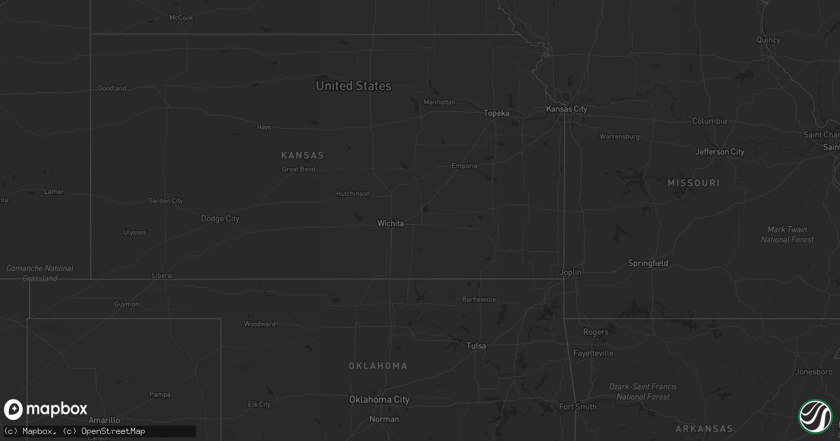
Hail Map in Minnesota on August 26, 2013
Get this storm
August 26 map
$229
one time, instant access
Download today. No call, no setup
Keep the $229
Bought the map and want the full workflow? Apply the entire $229 to a subscription within 7 days. None of it is wasted.
Every map, not just this one
This buys you this map. Subscription and you get every map we run, in the markets you choose from a few cities to whole states to nationwide. Plus real-time alerts the moment a storm fires.
Contact data
Name, contact info, occupancy, even credit band for addresses in the footprint. You go from where it hit to who to call.
Become the source they trust
Unlimited branding weather history reports on demand. You already have the documented answer ready for the property owner, and you are the one who showed up with it.
Property data and RoofTrace estimates
Pull up any address you have got, its value and the exact code rules for that jurisdiction, straight from One Click Code. Then RoofTrace estimates the squares, pitch, and roof value, priced the way you price.
Storm reports in Minnesota
Minnesota
| Date | Description |
|---|---|
| 08/26/20136:52 PM CDT | Hail fell for about a minute on the south end of vergas. |
| 08/26/20136:26 PM CDT | A local report indicates 1.00 inch wind near CORMORANT |
| 08/26/20135:58 PM CDT | Tree down at breezy point resort. Pea to nickel size hail. Numerous windows broken. Via social media. Time estimated. |
| 08/26/20135:40 PM CDT | Trees reported down on county road 1 east of pine river. Location estimated |
| 08/25/201310:14 PM CDT | Can hear hail hitting roof. |
| 08/25/20139:48 PM CDT | A local report indicates 1.75 inch wind near 2 S BRAINERD |
| 08/25/20139:48 PM CDT | Wind gust measurement taken with a handheld annometer. There is hail and wind damage to home. Holes in siding. |
| 08/25/20138:55 PM CDT | A local report indicates 2.00 inch wind near 4 N MOTLEY |
| 08/25/20138:22 PM CDT | A local report indicates 1.50 inch wind near 3 N VERNDALE |
| 08/25/20137:54 PM CDT | Relayed via social media. |
| 08/25/20137:51 PM CDT | Quarter to half dollar-sized hail. Winds in excess of 60 mph also reported just northwest of new york mills. |
| 08/25/20137:47 PM CDT | Various media sources posted reports and photos of hail larger than baseball size. |
| 08/25/20137:45 PM CDT | Several photos from media of hail larger than baseball size. |
| 08/25/20137:45 PM CDT | Hail up to 2 to 3 inches in diameter and 1.31 inches of rain. |
| 08/25/20137:43 PM CDT | A local report indicates 1.50 inch wind near 1 N NEW YORK MILLS |
| 08/25/20137:30 PM CDT | At least one large pine tree was snapped and several large tree branches were broken down. Peak winds estimated to 70 mph. |
| 08/25/20137:28 PM CDT | Pea to quarter size hail with winds estimated over 50 mph. |
All States Impacted by Hail Map on August 26, 2013
Cities Impacted by Hail Map on August 26, 2013
- Ladysmith, WI
- Brainerd, MN
- Garrison, MN
- Hillman, MN
- Cable, WI
- Mason, WI
- Grand View, WI
- Westby, MT
- Plentywood, MT
- Outlook, MT
- Antelope, MT
- Motley, MN
- Watford City, ND
- Aitkin, MN
- Palisade, MN
- Emily, MN
- Wadena, MN
- Perham, MN
- New York Mills, MN
- Bluffton, MN
- Verndale, MN
- Staples, MN
- Alamo, ND
- Detroit Lakes, MN
- Frazee, MN
- Vergas, MN
- Pelican Rapids, MN
- Moose Lake, MN
- Sturgeon Lake, MN
- Pinon, AZ
- Kettle River, MN
- Sabin, MN
- Pillager, MN
- Baxter, MN
- Fort Ripley, MN
- Nisswa, MN
- Crosby, MN
- Pequot Lakes, MN
- Merrifield, MN
- Plaza, ND
- Berthold, ND
- Kenmare, ND
- Hawley, MN
- Lake Park, MN
- Wakpala, SD
- Fort Yates, ND
- Wildrose, ND
- Phillips, WI
- Wright, MN
- Grand Canyon, AZ
- Barnesville, MN
- Eloy, AZ
- Fort Mcdowell, AZ
- Crosby, ND
- Killdeer, ND
- Flaxville, MT
- Sebeka, MN
- Audubon, MN
- Dent, MN
- Radisson, WI
- Coolidge, AZ
- Queen Creek, AZ
- Chandler, AZ
- Casa Grande, AZ
- Drummond, WI
- Crivitz, WI
- Porterfield, WI
- Barnum, MN
- Bruce, WI
- Weyerhaeuser, WI
- Marinette, WI
- Peshtigo, WI
- Mcgregor, MN
- Onamia, MN
- Sturgeon Bay, WI
- Marana, AZ
- Kerrick, MN
- Pickerel, WI
- Crandon, WI
- Tucson, AZ
- Arivaca, AZ
- Tony, WI
- Park Falls, WI
- Free Soil, MI
- Lac Du Flambeau, WI
- Exeland, WI
- Birchwood, WI
- Stetsonville, WI
- Custer, MI
- Scottville, MI
- Prescott, AZ
- Floodwood, MN
- Cromwell, MN
- Saint James City, FL
- Butternut, WI
- Cape Coral, FL
- Meadowlands, MN
- McGrath, MN
- Sandstone, MN
- Ambrose, ND
- Wabeno, WI
- Conrath, WI
- Holcombe, WI
- Sheldon, WI
- Gilman, WI
- Reed City, MI
- Holyoke, MN
- Sells, AZ
- Grand Rapids, MN
- Seligman, AZ
- Red Rock, AZ
- Akeley, MN
- Nevis, MN
- Grenora, ND
- Deerwood, MN
- Paris, MI
- Bruno, MN
- Ironton, MN
- Pine River, MN
- Ludington, MI
- Crosslake, MN


