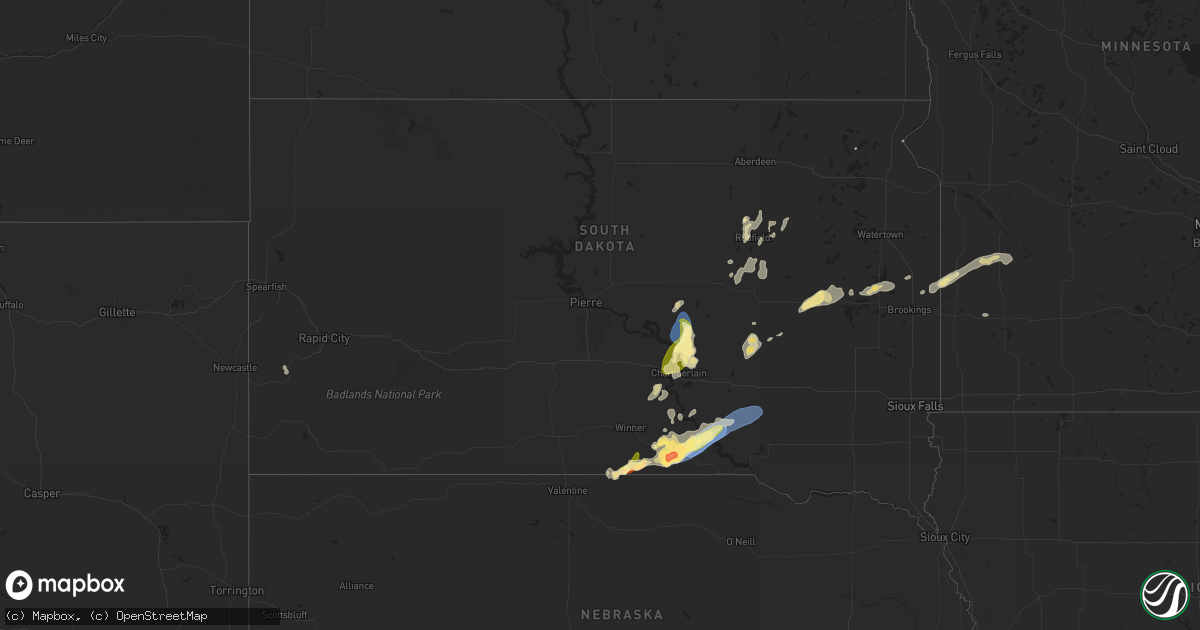
Hail Map in South Dakota on August 25, 2024
Get this storm
August 25 map
$229
one time, instant access
Download today. No call, no setup
Keep the $229
Bought the map and want the full workflow? Apply the entire $229 to a subscription within 7 days. None of it is wasted.
Every map, not just this one
This buys you this map. Subscription and you get every map we run, in the markets you choose from a few cities to whole states to nationwide. Plus real-time alerts the moment a storm fires.
Contact data
Name, contact info, occupancy, even credit band for addresses in the footprint. You go from where it hit to who to call.
Become the source they trust
Unlimited branding weather history reports on demand. You already have the documented answer ready for the property owner, and you are the one who showed up with it.
Property data and RoofTrace estimates
Pull up any address you have got, its value and the exact code rules for that jurisdiction, straight from One Click Code. Then RoofTrace estimates the squares, pitch, and roof value, priced the way you price.
Storm reports in South Dakota
South Dakota
| Date | Description |
|---|---|
| 08/25/20246:57 PM CDT | Hail smaller but still falling at 702 pm. |
| 08/25/20246:48 PM CDT | Considerable quarter to golf ball size hail with a few stones up to baseball size. |
| 08/25/20246:30 PM CDT | A local report indicates 1.00 inch wind near 12 NE Wewela |
| 08/25/20246:30 PM CDT | A couple windows broken in a camper and holes punched in siding due to wind-driven hail. |
| 08/25/20246:20 PM CDT | Hail lasted about 15 minutes |
| 08/25/20246:20 PM CDT | Damage to crops and structures due to wind driven hail. |
| 08/25/20246:20 PM CDT | A local report indicates 60 MPH wind near 12 NE Wewela |
| 08/24/202411:28 PM CDT | Tree damage in conde... Including a large tree falling on a garage. |
| 08/24/20248:53 PM CDT | Mesonet station 289 lees corner |
| 08/24/20248:05 PM CDT | Report from mping: 1-inch tree limbs broken; shingles blown off. |
| 08/24/20247:52 PM CDT | Report from mping: quarter |
| 08/24/20247:52 PM CDT | Personal weather station ksdplatt39. |
| 08/24/20247:50 PM CDT | Social media reports of numerous tree limbs down around platte. |
| 08/24/20247:47 PM CDT | Social media post of mesonet wind plot. |
| 08/24/20247:47 PM CDT | Report from mping: 3-inch tree limbs broken; power poles broken. |
| 08/24/20247:45 PM CDT | A local report indicates 69 MPH wind near 2 S Platte |
| 08/24/20247:40 PM CDT | Report from mping: 3-inch tree limbs broken; power poles broken. |
| 08/24/20247:13 PM CDT | A local report indicates 1.00 inch wind near 11 NE Burke |
| 08/24/20247:12 PM CDT | Personal weather station ksdherri4. |
| 08/24/20247:11 PM CDT | Trees uprooted or snapped. |
All States Impacted by Hail Map on August 25, 2024
Cities Impacted by Hail Map on August 25, 2024
- Chalmers, IN
- Helper, UT
- Duchesne, UT
- Vernal, UT
- Thompson, UT
- Protection, KS
- Hesperus, CO
- Coldwater, KS
- Follett, TX
- Dinosaur, CO
- Buffalo, OK
- Wilmore, KS
- Laverne, OK
- Durango, CO
- Monticello, UT
- Haviland, KS
- Maybell, CO
- Shattuck, OK
- Bucklin, KS
- Paradox, CO
- Sun City, KS
- Lake City, KS
- Kinsley, KS
- Glade Park, CO
- Springview, NE
- Winner, SD
- Reliance, SD
- Custer, SD
- Lower Brule, SD
- Oacoma, SD
- Colome, SD
- Chamberlain, SD
- Dallas, SD
- Gregory, SD
- Perryton, TX
- Medicine Lodge, KS
- Burke, SD
- Herrick, SD
- Kenilworth, UT
- Turpin, OK
- Platte, SD
- Balko, OK
- Booker, TX
- Saint Charles, SD
- Geddes, SD
- Tulare, SD
- Hamill, SD
- Redfield, SD
- Corsica, SD
- Harrison, SD
- New Holland, SD
- White Lake, SD
- Pukwana, SD
- Stickney, SD
- Ashton, SD
- Fort Thompson, SD
- Mellette, SD
- Gann Valley, SD
- Ensign, KS
- Fowler, KS
- Northville, SD
- Wessington Springs, SD
- Ree Heights, SD
- Highmore, SD
- Woonsocket, SD
- Alpena, SD
- Virgil, SD
- Saint Lawrence, SD
- Hitchcock, SD
- Wolsey, SD
- Wessington, SD
- Doland, SD
- Frankfort, SD
- Turton, SD
- Iroquois, SD
- Cavour, SD
- De Smet, SD
- Grenville, SD
- Roslyn, SD
- Lake Preston, SD
- Erwin, SD
- Arlington, SD
- Badger, SD
- Lake Norden, SD
- Sisseton, SD
- Bruce, SD
- Estelline, SD
- White, SD
- Toronto, SD
- Astoria, SD
- Hendricks, MN
- Ivanhoe, MN
- Porter, MN
- Minneota, MN
- Clarkfield, MN
- Taunton, MN
- Russell, MN
- Hanley Falls, MN
- Granite Falls, MN
- Balaton, MN
- Iowa Falls, IA


